

One of the best day walks in Australia, the Tarn Shelf Circuit explores the alpine section of Mount Field National Park. Starting at Lake Dobson, the trail initially passes through dryer Eucalypt forest before rising to Twilight Tarn and following the incredibly beautiful Tarn Shelf from Lake Newdegate to Rodway Hut. With spectacular glacier-carved tarns, lakes and valleys, this is a truly great all day adventure in the Tasmanian Wilderness
Distance: 15.5 km (loop)
Gradient: A mix of a gentle, slow ascent along the Tarn Shelf with some steep ascents and descents leading in and out
Quality of Path: Generally clear and well maintained trail with constructed steps and boardwalks
Quality of Signage: Trailhead does not provide clear info about the Tarn Shelf Circuit itself, however markers along the way and clearly marked trail junctions provide navigational information. Walkers are advised to study the Mount Field National Park brochure to understand the trail network before undertaking the hike
Experience Required: Bushwalking Experience Recommended
Time: 5-6 Hours
Steps: Many steps in place, particularly leading up to and down from the Tarn Shelf
Best Time to Visit: All year for different experiences, except on very hot days or during severe snow or storms
Best Time to Visit: All year for different experiences, except on very hot days or during severe snow or storms
Entry Fee: Yes. National Park Fees apply.
Getting There: The trail starts at Lake Dobson. From Gordon River Rd, take Lake Dobson Rd (Route C609) past the Visitors Centre all the way up to the Lake Dodson car park. Trailhead is located by the lake and initially follows the Pandani Grove Walk.
Having explored the Lady Barron Falls Circuit in the lower levels of Mount Field National Park the previous day, Alissa and I headed back into the park to tackle the Tarn Shelf Circuit in the alpine section of the park. Noticeably absent from Tasmania's Great Short Walks list, a deeper dive into the interwebs revealed the Tarn Shelf Circuit to be what looked like an incredible all-day circuit walk in an alpine environment. Further discussions with locals we met in the Walls of Jerusalem confirmed that this was one of the best day walks in Tassie, so we had to see it for ourselves.

Almost all the alpine walks in Mount Field National Park start on the shores of Lake Dobson. This a typically Tasmanian alpine lake, with a mixed forest of Pencil Pines and Eucalypts growing along the shore.

As a highly visited national park in Tasmania, the trademark boardwalks of the state's more tourist-friendly trails made an early appearance, and would continue to be a fixture of the walk whenever the track entered any muddy areas.
As the track entered the forest, Alissa and I reached a trail junction with arrows pointing towards an ascent as the route to take to reach the Tarn Shelf. Alissa and I decided to ignore this after Alissa read on Trip Advisor that the walk is actually more impressive in a counter-clockwise direction as the last leg walked in a clockwise direction is the least interesting. By doing the walk in a counter-clockwise direction, the scenery would get better and better, and as such we decided to instead continue on along the lake by following the shorter Pandani Grove Walk until it reached the next trail junction.

Pandani Grove is aptly named, as the area is filled with some impressively tall Pandani. A common sight along the Overland Track, Pandani had been noticeably absent from our visit to the Walls of Jerusalem so it was nice to see these interesting plants again.

The trail along the lake reaches a gravel service road, with the Pandani Grove Walk continuing to the right along the other side of the lake. At this point Alissa and I took the left turn up the road. There were no signs at this track junction, however we inferred that the other tracks must be heading away from Lake Dobson. Sure enough - a little ways up the road, a wooden sign indicated that we were heading towards Twilight Tarn, which was definitely along the route of the Tarn Shelf Circuit.

The initial stretch of the walk passed through dryer Eucalypt forest. This was pleasant and enjoyable but not exactly spectacular walking, and I could see why it would be better to get this part out of the way early on. The best parts of this section occurred whenever the track entered a clearing, and getting to see the reflections on the tarns and the views of the mountains in the distance filled us with anticipation for what was to come.

Button Grass was another Overland Track favourite we had not encountered in the Walls of Jerusalem, so it was great to see patches of this grass appearing along the track. For me, Button Grass's tussock shape not only brings back memories of the Overland Track, but also the similar looking (but unrelated) Spinifex of the Australian Outback as seen on the Camel Trail in the Pilbara's Millstream-Chichester National Park.

While Alissa and I did not bother with the side trips to Platypus Tarn and Lake Seal, we enjoyed the views of Lake Webster just before the track began its ascent. In the distance we could see the ridge of the Rodway Range. From this viewpoint, Alissa and I thought that we would be walking across the top of the range, however we would discover that the Tarn Shelf is actually just below the ridge.

At the north end of Lake Webster, a creek is crossed by an alarmingly low load bridge. A sign indicates that the safe load limit is one person with a backpack and that this is strictly for walkers only. This seems a little flimsy, however it also makes the bridge difficult for people on bicycles or dirt bikes to try and use. Coming from Western Australia where walkers are constantly being sidelined by yet another mountain bike development trying to be Blue Derby or dirt bikers brazenly using walk trails even though they are not designed for them, anything that keeps non-walkers off a walk track is a good thing as far as I'm concerned.

If the bridge didn't do the trick of keeping things strictly for walkers only, then the next section of the walk definitely would. This is a fairly rapid 300 metre elevation rise over about a kilometre and features the kind of rocky walking and rough steps that would make for a difficult ascent on any two wheeled vehicle.

The reward for getting to the top of the climb is Twilight Tarn, which is reached via a short spur. Sheltered by the adjacent peak and surrounding forest, this is a beautiful location and is popular as an overnight camping spot for walk-in campers. Upon our arrival, we saw a couple camping by the lake shore, and I could definitely see why they would have wanted to camp here.

Following the trail alongside Twilight Tarn leads to Twilight Tarn Hut. An old ski lodge built in the 1920s, Alissa and I agreed that you'd have to be really keen for skiing to stay in this location as it is still some distance below the tree line with no ski slopes immediately nearby. We did read however that Twilight Tarn used to freeze over and that it was used for ice skating. This does not happen anymore, which suggests the climate was a lot colder back in the day.

As with many of these old heritage huts, Parks and Wildlife discourage people from staying inside Twilight Tarn Hut, however the quality of the lodgings is not bad for a hut of its age. Given the work that has been done to preserve the hut, it is a shame that the walls of the bunk room are covered in graffiti.

The most interesting room in the hut is to the right of the entrance. This room is basically a mini-museum as it is filled with relics from the old ski lodge days, including old tins, utensils, hiking boots and skis.


After enjoying the history of the hut and stopping for lunch, Alissa and I got back onto the main trail as it continued its journey to the Tarn Shelf itself along a series of boardwalks.

The walking here constantly alternated between boardwalks and natural surfaces. Due to the recent snowfalls, there were a lot of puddles and muddy sections, and the track was a lot rougher along this stretch than along more touristy parts of the walk closer to the Tarn Shelf. At one point, the track split in two directions and we had to make an educated guess as to which way to go. Some cairns thankfully pointed us in the right direction, which reminded Alissa and I about the recent debate regarding cairn building. While I see why people may not be a fan of the mass sculptural cairn building that ignores Leave No Trace principles, cairns can often be the cheapest and most feasible track marker available and definitely have their place.

Towards the top of the ascent, the track became increasingly rugged and rocky as we made our way out of the Eucalypt forest and into the Pencil Pine forests.

Pencil Pines are amongst my favourite trees in Australia, and it was great to see these ancient trees in the surrounding forest as the track levelled out as made way to Twisted Tarn. Given that this is a fairly windy location, some of the Pencil Pines here are a bit stunted and twisted compared to the stately ancient stand near Dixons Kingdom in the Walls of Jerusalem.

A number of dead Pencil Pines and Eucalypts indicated that this area had been severely defoliated by a fire in the past. With Pencil Pines unlikely to recover, Snow Gums are the likely successors who will have to take up the mantle in this harsh alpine climate.

The constant creeks and the crystal clear water were highlights along this stretch of the walk. Given how clean and tasty Tasmanian mountain water is, I couldn't help myself and filled up my water bottle with water from the creek. The water was deliciously refreshing, and while I'm sure it was clean and safe to drink I did treat it with my Steripen just in case.

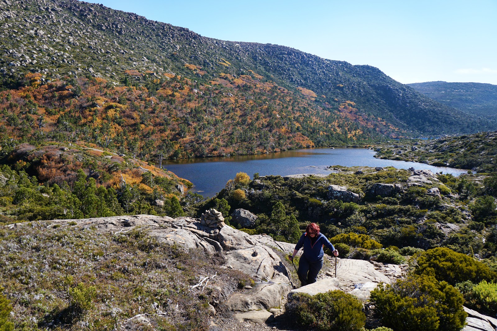
After walking along the creek system, the track descends towards Twisted Tarn. While Twisted Tarn was another pretty lake, Alissa and I were distracted by what lay beyond. From this vantage point, we could clearly see we were approaching the Rodway Range, and along its slopes we could see patches of orange, yellow, red and brown that indicated that we had come at a good time to see the turning of the Fagus (Deciduous Beech)!

Continuing past Twisted Tarn, the track reaches a major trail junction. The Mount Field alpine tracks are a bit of a choose your own adventure network that can be walked in a number of ways, with a track running off from this point to head up to the top of the Rodway Range and Mt Field West. Alissa and I agreed to leave the higher traverse for another visit, however we did follow the short side trip to check out Lake Newdegate Hut.

Located on the shores of Lake Newdegate, this hut looks like an old Parks and Wildlife Service Hut. As with Twilight Tarn Hut, this heritage hut is now only meant to be used as an emergency shelter.

The interior revealed a much less deluxe hut than Twilight Tarn, with rough floors and interior construction. The sleep platforms were not bad however, and I can imagine there being worse places to stay in a storm that Lake Newdegate Hut.

From the shores of Lake Newdegate, Alissa and I were able to get our first good views of the turning of the Fagus along the Rodway Range. We had already enjoyed seeing the Deciduous Beech along Lake Ball when we were on the Walls of Jerusalem Circuit, however we were mostly walking right next to them rather than seeing them from a distance.

Being able to see the patches of colour along the Rodway Range made for a spectacular sight, and we found that our pace dropped significantly from this point onward as the scenery was jaw-droppingly beautiful.

But it wasn't just the colours of autumn that made us constantly stop in our tracks. The Tarn Shelf is covered in a myriad of small tarns and lakes, and the track passes has been expertly routed through the area so as to provide a continually interesting and breathtaking walking experience.

With views of the tarns, mountain ridge, Pencil Pines and the Fagus, this walk features some of the best and most enjoyable alpine scenery Alissa and I have seen Australia.

The one negative of walking the Tarn Shelf Circuit counter-clockwise is that walking along the shelf from Lake Newdegate to the next trail junction near Rodway Hut is continually uphill. While most sections are fairly gentle, there are some moderate inclines and minor scrambling in places.
In spite of the slightly greater level of difficulty, Alissa and I agreed that we kept heading towards more and more impressive views, and that the extra challenge was worth it for the payoff.


Leaving Lake Newdegate behind, the smaller tarns continued to provide similarly spectacular views, however the Deciduous Beech seemed far less prevalent along this stretch of the track.

While the views of the Rodway Range were a major anchor for the walk, the track did not shy away from views to the east either. Passing close to a series of tarns along the cliff edge, the track provided views back to the first leg of the walk between Lake Dobson and Lake Webster.
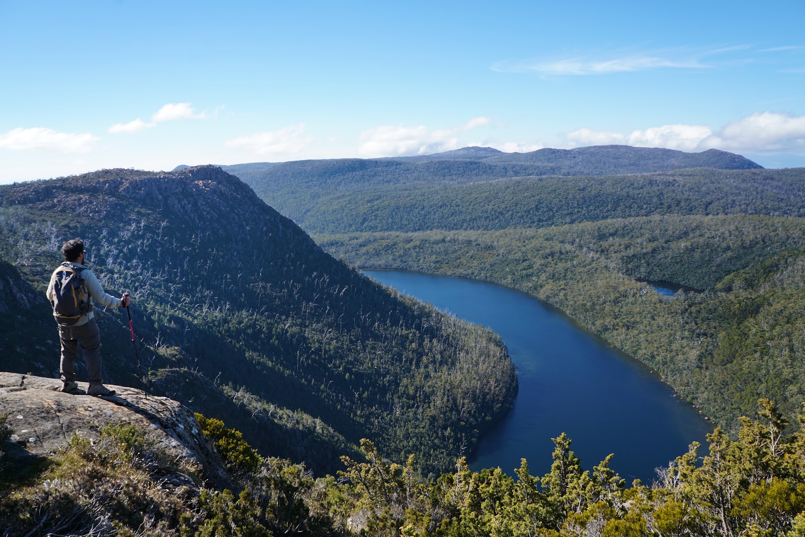
From a perfect lookout point, Alissa and I could see Lake Seal below. So named due to its shape, the head of the seal is unfortunately obscured around the corner behind the mountains. Also visible to the right is the smaller Platypus Tarn.

Clearing the middle section of the Tarn Shelf, the track reaches the last three substantial tarns - Johnston, McKenzie and Robert Tarn. The display of the turning of the Fagus along these tarns was once again spectacular. Being closer to the start of the track, this area was filled with heaps of tourists who were not doing the whole circuit but just wanted to see the autumn leaves in person, and unfortunately many of the best vantage points were taken as we made our way along.

With the golden colours of the leaves reflecting on the tarns, I could definitely see why this area was so popular - with clear skies and fine weather, this was the perfect day to be out on the Tarn Shelf.

Leaving the lakes and Tarns behind, the track continues up towards some old ski lifts and the Rodway Day Shelter.

Just as the Bibbulmun Track Huts are more properly shelters, the deluxe Rodway Day Shelter is more like a hut, and is the most well constructed along the walk.

With its benches and solid wood construction, Rodway Hut is easily the nicest hut up here and would be the best one to be stuck in if the weather took a turn for the worst in this unpredictable alpine region.

After Rodway Hut, another trail junction is reached with the higher route across the ridge branching off from the main track. From here, Alissa and I would follow the main track back towards Lake Dobson however the slightly higher vantage point along this part of the walk provided even more spectacular perspectives of the landscape. To the left we could see the reflecting tarns of Tarn Shelf and the fields of Deciduous Beach along the slopes of the Rodway Range, and to the right we could see Lake Seal below.

The track heads east along the ridge. Being less spectacular and featuring a wooden boardwalk for most of its length meant that we were able to pick up our pace here, which was useful given how slowly we'd made it along the Tarn Shelf.

At the end of the ridge, the track descends through a jumble of boulders and a forest of Snow Gums. There are some excellent viewpoints along this descent that would probably be the first great views for hikers doing the circuit in the clockwise direction. Being close to the end and having seen better views further along, Alissa and I didn't linger here for very long as we were keen to get going.

The twisted Snow Gums along the descent were beautiful. Snow Gums are amongst my favourite Eucalypts, with the particularly gnarled and twisted examples seen along the Main Range Track in Kosciuszko National Park being particularly iconic.

From the Snow Gums, the track basically continues its downward trajectory until it reaches the first trail junction Alissa and I encountered at Lake Dobson. From there it is a short walk along the boardwalks and back to the main car park.

When Alissa and I set off in the morning, there would have been no more than eight cars in the car park. When we go back, the car park was much fuller. Given the longer length of the track and the fact this area is pretty popular, it would be my advice to start this walk as early as possible to avoid the crowds.
As you may have guessed, Alissa and I loved the Tarn Shelf Circuit. This walk had everything we love about multi-day alpine walks in Tasmania like the Overland Track or Walls of Jerusalem Circuit but distilled down into an all day walk that is stunning and unique in its own way. The lakes and tarns were some of the most beautiful Alissa and I have seen, and we could not have timed it better to witness the turning of the Fagus along the Rodway Range (though maybe a bit less Sun would have been helpful from a photography point of view). This is definitely a must do walk in my opinion, and would easily rank right up there with the Main Range Track, Stapylton Amphitheatre, Coomera Circuit and Warrie Circuit as one of the very best all day circuit walks in the country.


I want to note: Above, the author mentions hiking in a counter-clockwise direction--with the aim of saving the best sites for last. WELL, we just completed this hike in Nov2019, and I can say, I am a healthy fit individual, but I recommend doing the hike in the standard Clockwise fashion. Going Counterclockwise means that you will be climbing UPHILL for extremely long stretches toward the middle and end of the walk--across boulders and tough terrain. Im not a world class hiker, but it seemed VERY challenging to do it this way. If you go Clockwise, you'll encounter long uphill climbs at the outset, but on milder terrain, and you'll be going downhill for some of the toughest sections.
ReplyDeleteAlso, separate note: If you come to the junction for the Platypus Path, and are facing the divided path, the sign is somewhat confusing as to which side is the path, and which is the PP. The PP is a dead-end vista, but is also a long downhill climb. It is the LEFT HAND path. If you want to avoid a down-up dead end, take the right hand main path, and save 30-40 minutes.
While i think the direction is up to the person.
ReplyDeleteI did this walk yesterday. Loved it. Performed Counter Clock wise. while it may seem that the up hill parts are bad, its not really, you are going uphill over a large distance. If going in a clock wise direction, the last hour of the trek is kinda boring.
Hello thelongwaysbetter, Excellent, Positive site, where u come up with the information on this posting? I have read a lot of the articles on your website now, and I really like your style. I think this kind of blog really helps Audience
ReplyDeleteFor more details on national park
Wildlife Safari
Bandhavgarh National Park Booking
Periyar Wildlife Sanctuary Booking
Satpura National Park Safari Timings
Manas Wildlife Sanctuary Safari Timings
Ranthambore National Park Booking
Jim Corbett Safari Timings
Kanha National Park Booking
Kaziranga National Park Safari
Sunderban National Park Safari