

Day 1 of the Abel Tasman Coast Track, this first section links Marahau to Anchorage. Starting at the track's southern trailhead, the day's walking initially follows numerous beaches before rising up to follow the rainforest-filled the coastal ridge. Passing waterfalls on the way, the trail descends to the spectacular Torrent Bay and Anchorage Hut. An easy first day and good start to New Zealand's most popular multi-day tramp
Distance: 12.4 km (one way)
Gradient: Largely gentle terrain with minor ascents and descents throughout
Quality of Path: Very clear and well maintained
Quality of Signage: Well signed at all trail junctions, with expected time and kilometre information to the next landmark
Experience Required: Bushwalking/Tramping Experience Recommended
Time: 3-5 Hours
Steps: Several minor steps in places
Best Time to Visit: All year
Entry Fee: No
Getting There: The trail starts at Marahau. From Nelson, follow Route 60 to Tataka Hill Highway and then turn right onto Riwaka-Sandy Bay Rd, which becomes Sandy Bay-Marahau Rd and then Harvey Rd. Trailhead is located to the right side of the road immediately after a left turn onto Marahau Valley RdEntry Fee: No

Reunited with Alissa is New Zealand a week after a work trip to New Zealand allowed me the opportunity to tackle the Karioi Track on my day off, the two of us flew from Auckland to Nelson to start our first New Zealand Great Walk - the Abel Tasman Coast Track. After a relatively short coach ride from Nelson to Marahau, Alissa and I found ourselves at the track's southern trailhead heading towards our first day destination of Anchorage.
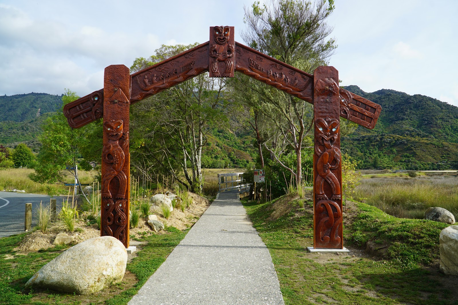
As befitting one of New Zealand's Great Walks, the track features a wooden archway carved with Maori iconography that serves as a great opening statement to the walk. As is often the case, Alissa and I were quick to get ready and were the first from our bus to be on our way, only stopping to assist a Canadian hiker who asked us to take a photo of her at the archway.

From there, Alissa and I began the track in earnest. After crossing a bridge over an estuary, the track initially runs through something of a green tunnel that offered little in the way of views.

This would only be a temporary stretch of pleasant but not overly interesting walking, however it did give us a chance to appreciate the quality of the track construction. Being the most popular multi-day walk in New Zealand by some margin, the track is exceptionally well constructed with perfectly formed track that is wide enough to not feel claustrophobic but not so wide that it feels like road walking. Additionally the signage on the track is fantastic; at major junctions the track provides expected time and kilometre information and there is very little ambiguity in the signage. While the track has a fantastic app that provides a lot of information and I would encourage trampers to always have a map, the clear and straightforward nature of the track and the excellent signage means this is very much a 'set it and forget it' walk that can be enjoyed with little regular navigational consideration.

Used to some fairly long days of hiking thanks to cutting out teeth on Western Australia's 1000 kilometre Bibbulmun Track, the other pleasant aspect of the Abel Tasman was the cruisy length of the days. Take the first day for example; at around 12 kilometres and less than 4 hours of walking, this allowed for a fairly easy going day with a lot of free time at the hut to chill out and enjoy the facilities.

15 minutes into the walk, the surrounding bushland opens up and provides some of the first real views of Abel Tasman's famous beaches. Part of Tinline Bay, Porters Beach is located near the estuary at the mouth of the Marahau River.

The waters were calm, placid and very inviting, however Alissa and I are not people who generally go for a swim when we have a lot more kilometres to go. Besides; our day would be ending at Anchorage with the hut only metres from the waters of Torrent Bay if we really wanted a swim.

Over the first few kilometres of the track, Alissa and I marvelled at how every single landmark seemed to have a name. Porters Beach. Goodman Gulch. Stu's Lookout. While very detailed, it would later seem oddly so given that later days of the track did not feature anywhere near as many signs, even at far better lookout points than the one above.


Something that struck Alissa and I very early on was just how many streams cross the track. Even though Abel Tasman National Park and the Golden Bay area are renowned for having the most settled and sunny weather in New Zealand, it was interesting to see that it wasn't the hot, parched land that Australia can often be. Alissa and I had been concerned that we might encounter hot weather given that even Tasmania can be uncomfortably warm for hiking in Summer, but what we experienced was absolutely perfect hiking conditions with sunny skies and temperatures in the low 20s.

At one point a creek flowing into the ocean reminded Alissa and I of the creeks that flow into Lake St Clair along the Overland Track, and particularly recalled the beach at Echo Point or the campsite at Fergy's Paddock.


Half an hour into the day's kilometres, Alissa and I reached Tinline Campsite - the first campsite on the track. While Alissa and I were following the orthodox hut-to-hut itinerary for the Abel Tasman Coast Track as per DOC's brochure for the walk, the track features numerous walk-in campsites for tent-based camping dotted along the track. With the limited places in the huts being snapped up quite quickly, the campsites offer alternate itinerary options and can often be in even better locations than the huts. Ultimately, given the strictness of both New Zealand AND Australian Customs, Alissa and I were glad to have the convenience of the huts and not having to deal with lengthy inspections at both ends.

From Tinline Campsite onwards, the track gently rose up away from the beachside walking that had dominated track up to this point. The track from here on was often a cutting along the coastal ridge, with the forest becoming lusher and more dominated by beech rainforest species.

It was during this stretch of the track that Alissa and I encountered our first Weka. A flightless bird that looks very much like a chicken, these birds seem largely unfazed but the regular human encounters along the track. This first Weka came right up to Alissa and I, and seemed quite reluctant to move off the track.

While the track may have been a greater distance from the ocean and more enclosed by rainforest, natural clearings in the forest provided excellent views down to the coastline.

Even in the stretches without views, the lushness of the rainforest provided beautiful and engaging scenery. As a fan of both forest and coastal walking, Alissa was in her element - especially since the terrain for this first day was mostly gentle and easy going.

Given the amount of water flowing through the area, it was unsurprising to see the first of many waterfalls along the track between Tinline Campsite and Apple Tree Bay. While we would see even larger waterfalls further along the walk, this was a lovely little scene that recalled the beauty of the Coomera and Warrie Circuits in South East Queensland.

Another small but lovely encounter along the track was a baby weka. While less calm and tame than the mature weka we met earlier, it still lingered around long enough for me to take a photo of it before it hid behind some bushes. Alissa and I pointed it out to some local children walking along the track who were no where near as excited by the bird spotting as we were. By the end of the walk these flightless 'chickens' would become a common sight, however we were still marvelling in the newness of hiking in a land we'd never been before.

Shortly after, Alissa and I crossed Simoner Creek over a footbridge. While I'm sure New Zealand's fire risk is far lower than in Western Australia, it was a pleasure to see nice looking bridges along the walk rather than the fireproof but ugly concrete structures that are becoming more common in Bibbulmun Track rebuilds after fire.

Simoner Creek featured a lovely slide waterfall cascading down the rock. Given how much I loved the Gondwanan forests of South East Queensland, it was fantastic to see similar scenery here in New Zealand but will cooler weather - and with stunning coastline thrown in as well.

With the walk being largely straightforward to this point with no real side tracks, the junction leading to Apple Tree Bay gave Alissa and I a chance to take stock of how we were travelling. We saw from the sign that we were travelling faster than the average pace listed on the sign by about 25 minutes, and we were happy to see we were almost halfway. At this pace we were confident we would be getting into Anchorage within the next two hours - as long as the terrain remained as gentle and moderate as it had been up to this point.

We were now well and truly in the beautiful beech forests of the area. The Southern Beeches, known by their genus Nothofagus, are a genus that have been around for millions of years, and their presence is generally a clue to the shared Gondwanan heritage of the southern continents of Earth. Alissa and I have enjoyed walking through deciduous beech forests many time in Tasmania - particularly during our Autumn visit to the Tarn Shelf Circuit - and it made Alissa and I very happy to be walking in the lands of their close cousins.

The walk continued onwards along a cutting through the coastal ridge, and while very pleasant at times it was a green tunnel with little in the way of views. While not super exciting, it more than made up for it by being very even with few ascents or descents of note. Alissa and I concurred that this was a great first day of a track, as the relatively easy going nature of the terrain meant we could ease into the walk. This of course had been our intention, as our second Great Walk would include an 800 metre ascent on its second day...

More small waterfalls followed in Gondwanan fashion. It was incredible how lush the area was; this is supposed to be the most dependably sunny part of New Zealand and yet it had a lushness that was more akin to Tasmania than the stinking hot and dangerously dry conditions of the famously sunny Perth Summer.

The track offers some lovely views down to Stilwell Bay, with Adele Island featured in the background. At this point Alissa made a few cheesy jokes about the singer Adele that I was unfortunately not a receptive audience for.


Rounding the other side of Stilwell Bay, Alissa and I could see that there is a hut located on its shores. This is not a DOC hut that can be stayed in, and given the large number of kayakers on the beach it made us wonder if it was a private building used by the tour operators.

Another track junction an hour and ten minutes after the Apple Tree Bay turn off was the home stretch of the day's walking; from here it was 1.6 kilometres mostly downhill to the hut and stunning beach of Anchorage Bay.

The vegetation along the descent to Anchorage changed from the lush beech forests that had dominated most of the day's kilometres up to this point to a more open and drier coastal heath and low woodlands that certainly looked a lot more like the vegetation one might expect to see in an Australian coastal walk.

A short side trip leads to a lookout point that provides expansive views of Cyathea Cove and Adele Island.

While the lookout was certainly a worthwhile short excursion off the main track, the real prize was the view of Torrent Bay from the main track. The bay is truly magnificent with the granite karst system recalling the similarly shaped karst formations of Vietnam's Ha Long Bay more than the harder granite headlands common in Australia.

Given the quite considerable tidal conditions of the Abel Tasman coast, the bays of the walk often feature estuaries, and it was lovely watching the ducks paddling in the freshwater section leading down to the beach.

Following the estuary downstream, the stream reaches Torrent Bay as it flows into the ocean. From here the track skirts the edge of the beach while providing sweeping views of the bay. With all the boats anchored in the aptly named Anchorage, Torrent Bay reminded me of a much larger version of Refuge Cove on the Wilsons Promontory Southern Circuit or a yellow sand version of Western Australia's beautiful Lucky Bay.

After teasing us by skirting the edge of the beach, the track alignment eventually drops down onto the beach for a short stretch of beach walking towards Anchorage Hut.

Located near the eastern end of Torrent Bay, Anchorage was our first experience of a New Zealand Great Walk Hut and it was easily one of the nicest huts we've ever stayed at.

Similar to the larger huts on the Overland Track, Three Capes or Frenchmans Cap in Tasmania, the hut features a massive common room stacked with tables and benches and more than enough room for all hikers to cook their meals, play games and socialise.

If there is one negative of multi-day hikes it is often the sleeping setup with is filled with endless compromise and a resultant lack of sleep. It was a relief to find the sleeping conditions were exceptional for a public hut, and a step up from any hut we've ever stayed in. The hut featured numerous rooms with each featuring individual bunk beds with actual mattresses. While it may not be a twin share room in a private hut, this was luxury compared to the packed in like sardines layout on hard wooden boards that are common on most hut-based walks (if huts are provided at all of course!).

And to top it off, the water for the walk came treated which meant I could keep the Steripen away for the rest of the walk!

While the hut itself is spectacular, the choice of location was also perfect. The hut was designed to sympathetically take in the beauty of its Torrent Bay location, with a massive window providing views of the bay. It may not have been quite as spectacular as the view from Lake Tahune Hut on the Frenchmans Cap Track but it was nevertheless one of the nicest on any walk we've done.

After unpacking our gear and having lunch, Alissa and I decided to go for a short walk around to explore the campgrounds and the surrounding area. The camping area was nestled in a lovely stand of coastal forest, with a stream flowing into the bay on the other side. This was again very similar to the geography of Refuge Cove on the Wilsons Promontory Southern Circuit.

Walking down from the stream to the beach, Alissa and I took in the panoramic beauty of the area. The Lonely Planet Guide to Hiking and Tramping in New Zealand sold this walk as a beach holiday on foot, and the sunny weather, low 20s temperatures and gorgeous scenery certainly lived up to the hype.
This day from Marahau to Anchorage was a fantastic first day of the Abel Tasman Coast Track, and in a lot of ways it was a model first day for a multi-day walk. While there were moments of sameness that prevented it from being entirely spectacular from start to finish, there were no real dull moments over the day, and the relatively easy length and terrain made this a good opportunity for us to get into the groove and ease our way into the Great Walk experience. Ending the day at such a great hut completed the picture, and made us excited for what else the Abel Tasman Coast Track had in store for us.
0 comments:
Post a Comment