

A classic overnight/long day walk in Alpine National Park, the southern Razorback Track takes hikers to the summit of Mt Feathertop - the Queen of the Victorian Alps. Starting at Diamantina Hut, the track traverses the stunning ridgeline of the Razorback as it makes its way to the second tallest peak in Victoria. With a stunning campsite at Federation Hut, this is a must do Australian hike
Distance: 22 km (return)
Gradient: A mix of a steadily undulating terrain with some steep ascents and descents
Quality of Path: Generally clear and well maintained trail
Quality of Signage: Clear trailhead at the start of the walk and signage at trail junctions
Experience Required: Bushwalking Experience Recommended
Time: 2.5-4 Hours each way, depending on how much you want a pie at the end
Steps: Many steps in places, particularly leading up to the summit
Best Time to Visit: Spring-Autumn, except on very hot, windy or stormy days
Best Time to Visit: Spring-Autumn, except on very hot, windy or stormy days
Entry Fee: No
Getting There: The trail starts at Diamantina Hut on Great Alpine Rd. From Harrietville, continue along the winding road for 28 kilometres. Parking is on the opposite side of the street downhill from Diamantina Hut
With a two week stint in Melbourne for work, a free weekend in Victoria gave me the perfect opportunity to tick another Victorian walk off my bucket list. With so many great walks to choose from and with perfect weather forecast in the high country, I decided to head out to Alpine National Park to tackle the overnight hike to Mt Feathertop - which surprisingly enough, would also serve as my first ever solo overnight hike (I know, right?). Having conferred with my Victorian hiking buddy Kevin from Goin' Feral One Day at a Time, my initial plan to tackle the much more challenging Bungalow Spur was changed to instead follow the highly regarded Razorback Track to a mountain that is often referred to as the Queen of the Victorian Alps.

The drive up to the start of the Razorback track on Great Alpine Road was an event in itself, heading up to the high country on a long and winding road along the cliff tops. There is a real danger of driving off the edges of this road, so I had to be completely paying attention to what I was doing. This was made all the more difficult thanks to the constant stream of cyclists

Crossing the road to the Razorback Track's main trailhead, I was already blown away by some of the best alpine views I've experienced in Australia. The weather and clear skies were absolutely perfect, and I could even see the top of Mt Feathertop peaking out from beyond the ridge. Right away, I knew I was in for a great walk.

The trailhead is located on the north side of the road at the start of the Razorback, and features a well appointed trailhead with information about all the walks that can be done in the area.

Given that this is an overnight walk in the high country, a log book is located at the trailhead for visitors to fill out with their trip intentions, and with a tick box at the end of each line for hikers to indicate that they have made it back safely.

The first part of the walk follows the gently undulating rolling hills of the Razorback, and provide relatively easy going and scenic walking. Being late Spring, the alpine wildflowers were blooming and provided excellent bursts of colour through the alpine meadows.

A short way into the walk is the first trail junction to the Bon Accord Spur. My initial interest in Mt Feathertop came from reading about it in John Chapman's classic Bushwalking in Australia, where he writes up a circuit walk from Harrietville up the Bungalow Spur and then across the Razorback and back down to Harrietville along the Bon Accord Spur. This is one of the most classic circuit walks in the area, and one that I'd love to tackle some other time.

But on this occasion I would be continuing straight along the Razorback. During this early part of the walk the track attempts to avoid the highest part of the ridge by skirting around the edges. Occasionally these narrow tracks can be close to the edge and slightly eroded, and I can see how the Razorback can be a little hazardous in inclement weather given how exposed this area is.

The gentle avoidance of the hills ends as the track reaches its first major climb. While a track runs around the edge of the mountain, on this first pass through I decided to head right over the steepest part. This is the view looking back at the descent; this was extremely steep and I made a mental note to try the lower path on the way back to the car park.

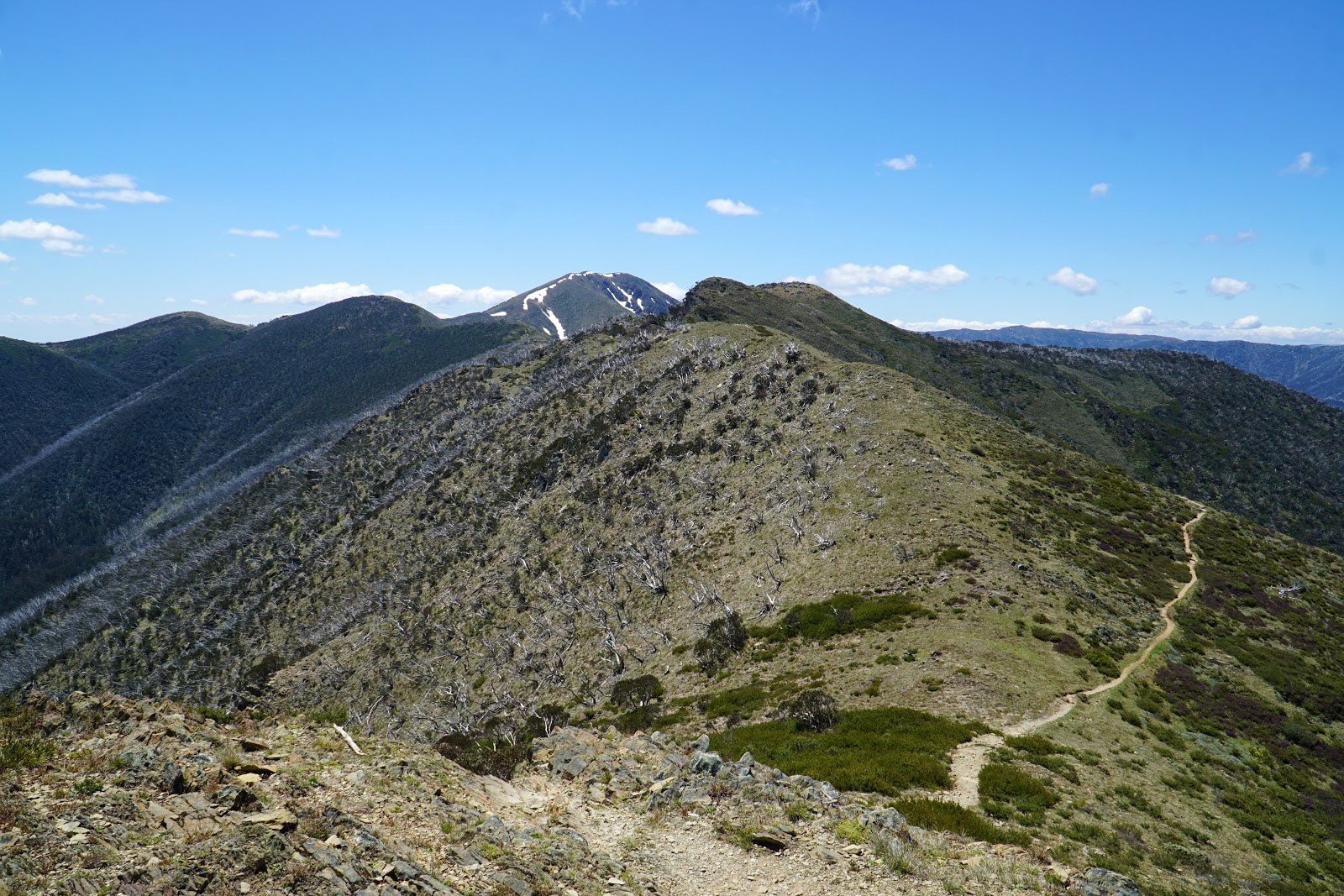
Clearing this first major peak of the Razorback, I had my first truly great view of Mt Feathertop. Due to the highly eroded nature of the Great Dividing Range, many of the mountains in the Australian high country are rounded domes - this was definitely my experience when we tackled the Main Range Track in Kosciuszko National Park. Mt Feathertop is an rare exception, as it features a classic pyramid mountain shape. Its shape and its height as Victoria's second tallest mountain is the reason that Mt Feathertop is so widely beloved by Victorians as a classic bushwalking destination.

While the walking had been excellent so far, there were definitely a lot of sad reminders for what once was a major attraction of this walk. A bushfire in 2003 ravaged this entire region, and it is devastating to see the bleach white skeletons of entire forests of trees absolutely decimated. 15 years after the fire, there are still areas like this across the Razorback Ridge that show that recover is happening very slowly.

With the Razorback dipping down below the tree line, the track passes through an area that would have been a lovely Snow Gum forest before the fires. One of my absolute favourite Eucalypts, I loved seeing the snow gums in places like the Tarn Shelf Circuit in Tasmania and on the Main Range Track. Seeing this whole area totally destroyed filled me with great sadness for what would have been a lovely highlight of the walk, but instead is now something of a sad lowlight on an otherwise great track. By this stage I was also getting pretty hot and sunburnt; I couldn't find my hat when I parked the car and I had spent the entire day basically walking into the Sun - a most unpleasant factor in what was a perfect day in all other respects.

Leaving the dead forests behind, the track begins to rise rapidly as it makes its way up from the lowest point of the ridge. This area seems to have escaped the worst of the fires, and with its relatively dense tunnel of foliage made me think of the Stirling Ridge Walk back in Western Australia.

The steep climb began to mellow out as I reached the top of the next ridge, with a mildly undulating path leading me to what looked like an excellent lookout point.
The view was slightly less exciting than I had hoped, but it did show the track gently rounding the edges of the ridge's peaks. Having dropped beneath the tree line and with views obscured, I hadn't seen Feathertop for a while at this stage, and it was a nice surprise to see that I was making good progress.

While I felt safe for most of the walk, the track skirting the edge of the ridge along this stretch of the track was probably the most potentially dangerous section of the entire walk. The track here is narrow and eroded, with a steep drop off to the east and some slightly rugged sections to negotiate. This was safe enough at the time of walking, but could be risky if the rocks are iced over from snow melt. The track is best avoided completely in winter as it is too dangerous and impassable.

Continuing along, the track passes through a shallow cleft in one of the taller peaks of the ridge. This sheltered area seems to be used as a campsite by some walkers looking to escape the larger crowds of the popular Federation Hut campsite.

After clearing the sheltered area, I was granted my first truly great view of Mt Feathertop, with it eastern slopes being completely visible. It was interesting to see how far down the mountain the patches of snow went and to see that its peak-like shape continued down into the valley. With so few mountains in Australia having both this classic peak shape and actually being tall, this was a truly rare and breathtaking sight.


Continuing along the ridge, I could make out a hut in the distance to the west. I knew that this meant I was getting close to Federation Hut - my campsite for the night.

With Federation Hut getting closer and closer, I reached the end of the Southern Razorback and a trail junction. To the right is the track to Mt Feathertop, while walking straight ahead takes you to Little Mt Featherop. Turning left, I followed the track to Federation Hut where I would be able to finally take off my pack and pitch my tent. It had been 6 months since my last overnight or multi-day hike, and I realised I'd gone soft in that time when it came to a heavy pack with overnight gear!

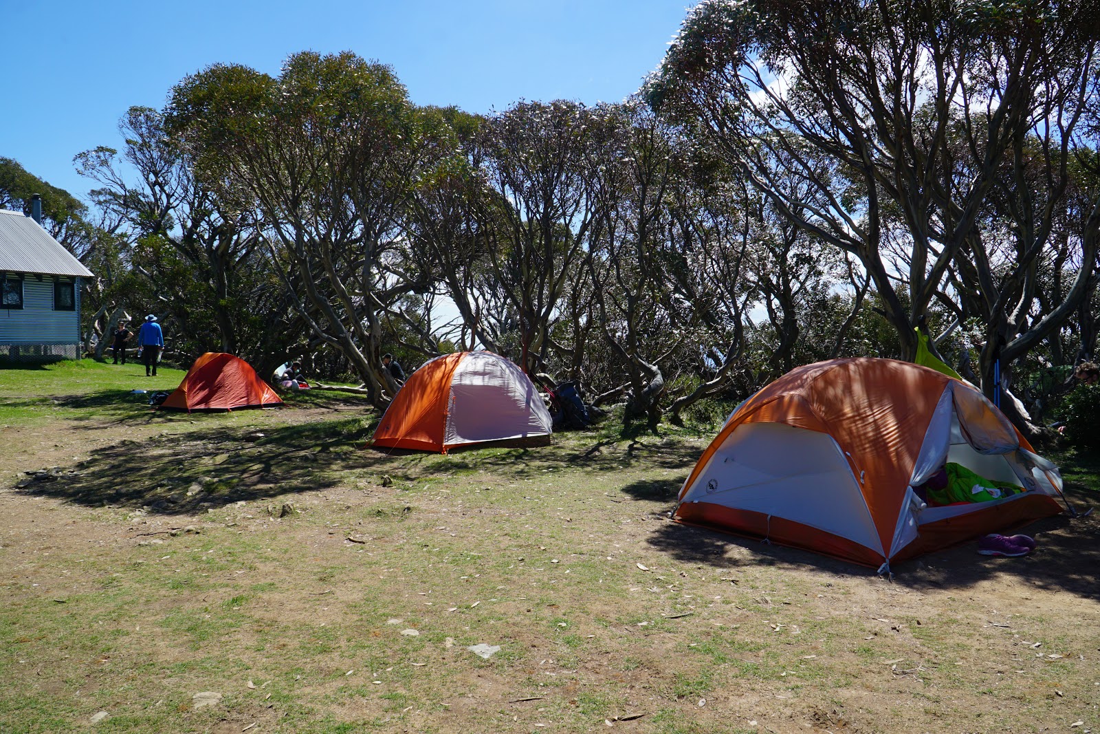
The 2003 fires had burnt down the previous Federation Hut, which was conveniently located close to a spring. The new hut and campsite is a bit closer to the summit, and is located in a grove of Snow Gums that had miraculously escaped the ravages of the fire. This campsite is outstanding, as it features a lot of clear areas to set up a tent, an Overland Track-quality toilet and stunning views of the surrounding landscape. Seeing another Big Agnes Copper Spur, I decided to set up next to them - my tent is in the middle. Later in the evening when the winds blew in and nearly flattened the foot end of my tent, I regretted setting up where I did and I would recommend looking for a more sheltered place instead.

Federation Hut is quite a lovely modern hut that nevertheless has an old school style to it that is probably a lot less objectionable to hardline traditionalists than the contemporary style that has popped up in Tasmania at Windy Ridge/Bert Nichols, the Three Capes Track and the recently built Lake Tahune Hut on the Frenchmans Cap Track.

Being an emergency shelter only, the hut does not feature any sleeping bunks. I don't really get why the culture surrounding the high country huts in Victoria seems to be so against people staying in the huts, but given the high popularity of Mt Feathertop and the windiness of the area, the fact it can be used as a reliable kitchen out of the cold and the wind makes it a useful 'common area' for campers to mingle and get their dinners ready. In this regard, Federation Hut was not dissimilar to the hut at Dixon's Kingdom in the Walls of Jerusalem, which similarly is not really a place for hikers to stay but can be utilised as a nice room to get out of the elements, cook a meal and talk to other hikers.

From the Federation Hut campsite, the views back across the Razorback are magnificent. This would easily rank amongst my favourite campsites that I've stayed at in Australia, and as an added bonus it was completely free!

After chilling out in my tent and messaging friends and loved ones back home, I decided that I had so much time to kill that I might as well go climb Mt Feathertop, so with a mercifully light day pack containing my medikit, PLB and some light snacks, I head back to the trail junction to walk up to the summit of Victoria's second highest peak.

Along the track, another trail junction is reached. There are multiple ways of reaching the summit of Mt Feathertop, and turning left follows the Northwest Spur route.

Looking towards the Northwest Spur, I could see the geodesic dome of the MUMC Hut. This cool and retro-futuristic looking hut is another potential overnight campsite for those tackling Mt Feathertop, and I would love to try the ascent from the Northwest Spur as a future visit.

The track up to the summit is fairly short but relentlessly uphill. Walking with a day pack did however make it a lot easier than it would have been with my full pack, and I was grateful for the fact I could leave my gear at Federation Hut and do this with a much lighter load.

The views from the ascent are excellent as they take in the surrounding mountains and valleys. Even in late November there were many patches of snow along the ascent, however all of them were off track and in areas that are prone to collapse. On average, a person dies on Mt Feathertop every decade from standing on one of the cornices of snow only to find the ground beneath them fall away as they slide down into the abyss below. For this reason, all walkers are advised to never walk on the snowy cornices of the mountain.

After the steep climb, the track levels out and provides a relatively easy walk from the mountain's lower summit to its true summit.

Walking across the top, I could see the most notorious summit cornice. This is the one people tend to walk on, and the precipitous drop to the valley below looks like the kind of fall from which there is a very low likelihood of survival.

I was lucky to reach the summit just as a few small groups were leaving. I watched as they all made their way back along the summit ridge, and I then had this magnificent summit all to myself.

While the summit cairn is one of the most pitiful I've ever seen (much smaller and less grand than Western Australia's second tallest peak at Mt Bruce), the views from the summit were nothing short of magnificent. The view was particularly spectacular to the north-east, and it was significantly more impressive than the view Alissa and I had from the summit of Mt Kosciuszko. While Feathertop is tall by Australian standards, this is a classic example of why height is not the only defining aspect of what makes a mountain great and why as much as I hope to one day complete the State 8 (the tallest mountains of every mainland state/territory), the goal is really quite an arbitrary one when smaller peaks can often be better.

After returning back to camp and socialising while having dinner, I headed out to bag another peak and to take in a beautiful alpine sunset. Rather than climbing Feathertop again, I decided to tackle the short side trip up Little Mount Feathertop instead.

Little Mt Feathertop is a great vantage point from which to view the summit Mt Feathertop, and I enjoyed being up there as Feathertop was bathed in the glow of golden hour.

Across the summit of Little Mt Feathertop, the dead skeletons of the snow gums looked like fingers reaching to the heavens, and I made a mental note that they would be perfect for my sunset photograph.

As the sun began to set, the landscape's golden glow and the view of the surrounding mountains made the view from Little Mt Feathertop look like an image from a catalogue by Kathmandu or Mountain Designs (RIP). Just magnificent.

As the sun set, I got my sunset shot, with the skeletons of the snow gums providing a lovely silhouette to frame the end of an amazing day. After returning to camp, I basically decided to just stay in my tent. The campsite was extremely cold and windy, and I found my down jacket and the warm ski gloves I bought for hiking in Tassie were only just keeping me warm! It was actually colder than when we camped in the Walls of Jerusalem, probably due to the extreme wind chill factor. While it initially kept me awake, the winds eventually died down and I was able to have a semi-decent sleep.

The next morning, I woke up to another glorious day in the high country. After a quick and easy breakfast of a Clif Bar, I packed up all my gear and semi-reluctantly made my way back to the trail junction and along the Razorback.

Walking back along the Razorback was easy to begin with, but featured some steep climbs out of the low point of the ridge. Nevertheless, I was driven by my desire to get a 10 on a Plate (sausage roll and pie together in the shape of the number 10), and I found that I somehow managed to walk back in 2.5 hours!


Hey Don, it's great that you enjoyed your walk. Next up you'll have to have a look at Howitt to Speculation across the Cross Cut Saw, it's another classic :)
ReplyDeleteThanks for an amazing walk through of the place. Your article felt like 3d Virtual tour while i was reading. We are planning our first ever overnight hike, (as beginner) and this blog is very helpful. Thanks
ReplyDeleteThanks for this. I really like what you've posted here and wish you the best of luck with this blog and thanks for sharing. Drone Mapping Albany
ReplyDelete