
Day 10 of the Munda Biddi Trail, this section takes cyclists from the trail town of Collie to Nglang Boodja. Following the pleasant spur out of town, the Munda Biddi crosses Colliefields Hwy into Wellington National Park. Following an insanely steep descent to the Collie River and a side trip to the spectacular Honeymoon Pool, a slow gentle ascent leads to the lovely Nglang Boodja. One of the Munda Biddi's most epic and rugged days
Distance: 43.2 km (one way; add 2.4 for Honeymoon Pool side trip)
Gradient: Some undulating areas with some moderately steep climbs and descents, with one extremely steep descent to the Collie River
Quality of Path: Mix of vehicle tracks, high quality rail trails and some single track
Quality of Signage: Mostly well signed at all trail junctions
Experience Required: Mountain Biking experience recommended
Time: 4-5 Hours
Steps: None, though some of the black diamond descent to the river could very well be considered steps
Best Time to Visit: All Year; but the South West of WA is always best from August-October
Date(s) Completed: 8th June, 2020
Entry Fee: No
Getting There: No direct access to Nglang Boodja. Car access points can be located at Colliefields Hwy, Wellington Dam Rd and River Rd

Having gone back to complete Jarrahdale to Dwellingup after the prescribed burns and then skipping ahead for the July school holidays to complete most of Pemberton to Denmark, it would be two months before Alissa and I would return to Collie to pick up where I had left off last time I'd cycled the spur into town. Although I considered maybe skipping doing the spur trail twice and instead picking the Munda Biddi back up closer to the trail junction heading south, I decided that the long way's better, and that I should be a trail purist and do it as it would be experienced by an End to Ender.
With it now being early August, the rainfall had made quite a difference to the trail. The Munda Biddi goes around the puddle/pool pictured above, and at the time of cycling into Collie it was at least half the size.
My memory of the ride into Collie was that it was mostly downhill and I was kind of dreading the ride out to the spur going in the opposite direction. As it turned out, the ascents were fairly gentle and easy going, and I actually found the ride to be a surprisingly pleasant and enjoyable experience - particularly along the old Wallis Form.
With all the fallen trees I'd encountered in June having been dealt with by DBCA or the maintenance volunteers, I was surprised to find myself at the trail junction just over an hour after leaving Collie.
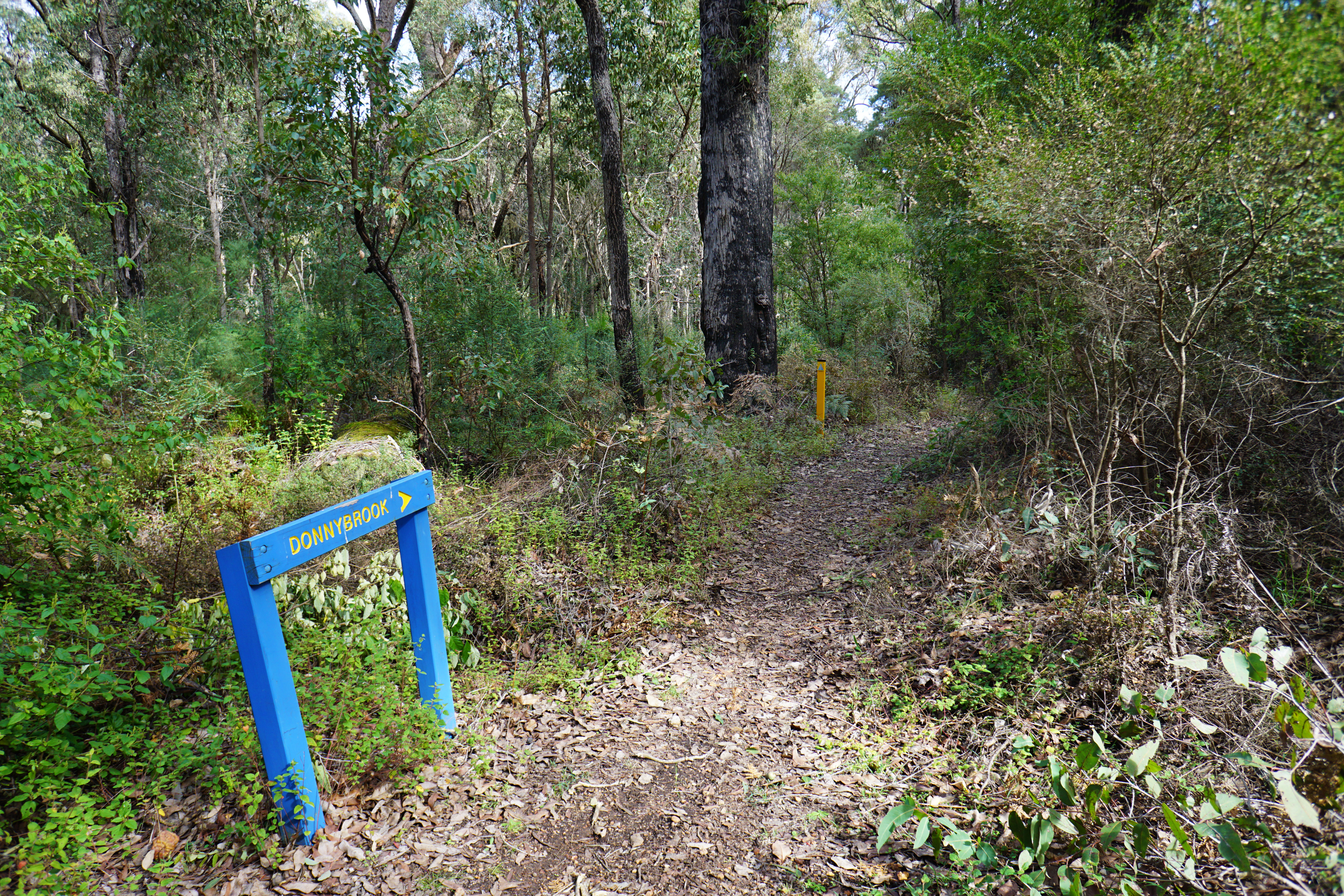
The trail junction is well signed, with a stretch of single track forming the beginning of the trail to Donnybrook.
When I was here in early June, I'd been thoroughly impressed with the forest quality near the trail junction, and heading along the trail to Donnybrook the excellent tall forest continued with this mature giant being right before a creek crossing.
After the creek crossing, the single track comes to an end as the Munda Biddi follows what is thankfully the only stretch of powerlines for the day, and only 150 metres at that.
Turning back into the forest, the Munda Biddi passes through what would have once been a massive tree. Upon seeing it, I immediately recognised it as the same spot photographed for the cover page of the Munda Biddi Trail group on Facebook, and couldn't help but try to recreate the photo (albeit with an empty bike as I had no one else to pose for or take the photo).
The trail continues onward through fairly scrappy looking forest, and at times the trail alternates from a bit faint to deeply ripped up by dirt bikers.
At one point, the trail looked so badly ripped up by dirt bikers that it had formed a small gutter in the single track, and this continued onwards for quite some time.
The sand was annoyingly loose and made taking corners at speed quite difficult. Not long after I nearly fell over on a sandy bend, it dawned on me that I hadn't seen a Munda Biddi marker for some time. As the trail quality deteriorated further, I'd realised I'd gone the wrong way! Realising my mistake and knowing I was generally heading west, I decided to continue on this unsanctioned track on the assumption it would likely join back onto a vehicle track that I could then use to get myself back on track.

Ideally these sort of situations should not happen, but it is illustrative of why it is essential to always carry a map and, more importantly, understand how to read it and the landscape around you. Following the vehicle track, I was able to quite quickly get a sense of where I was. Knowing that the Munda Biddi crosses a railway line, I followed the vehicle tracks to the railway and was able to find the Munda Biddi just off the vehicle track that runs along the railway line. I was annoyed at my mistake and for the wasted time, however I had to remind myself I'd probably only lost 20-30 minutes in the grand scheme of things.
Back on the Munda Biddi, the trail crosses the railway line and follows vehicle tracks. This stretch following unsealed roads is less than ideal, however it is earmarked for a much better realignment as part of the Collie Adventure Trails project.
The highlight of the road cycling was the views of the farmland filled with cows. The first group I encountered were a fairly shy bunch; as soon as I came close enough to photograph them, they stampeded away.
Turning briefly onto Gastaldo Rd, the Munda Biddi follows the road briefly before heading through more farmland.
Along this second stretch of farmland, the cows were much more inquisitive. As I approached them to take a photo, they actually came closer to investigate, and as I cycled away they followed me along the fence until I eventually outran them.
I'm always intrigued by how road and rail networks used to look in another time, so I was intrigued by the overgrown, sealed road that the Munda Biddi goes along to cross Coalfields Hwy and to enter Wellington National Park. Looking at Google Maps later, I would realise that the realignment of Coalfields Hwy was the reason for the change; previously, Coalfields Hwy ran further north than its current alignment and this would have been part of the drive into Wellington National Park. These changes were so recent, you can still see Coalfields Hwy being built where it currently crosses Wellington Dam Rd in Google Maps' Street View.
Crossing the busy highway, the Munda Biddi heads along Wellington Dam Rd as it enters Wellington National Park before then veering right into the forest on an old vehicle track.
Having watched videos of this section online, I knew that the ride through Wellington National Park would be largely downhill, and while there were a few minor undulations, the terrain was mostly gentle, easy going and with a downward trend. The last time I had been in Wellington National Park, I'd been bitterly disappointed by a seriously over the top hot burn along the Wiilman Bilya Trail so I was pleased to see that this early stretch of riding in the park was in much better condition.
The trail turns onto Windy Ridge Rd as it rolls downhill, thankfully only staying on the road for 1.4 kilometres before turning back onto bicycle only trails.
With much of the trail here being downhill along single track, this section of the Munda Biddi was a real pleasure to ride, and with minimal tree charring and wildflowers beginning to bloom I was really enjoying the scenery as well.
The only problem was that I'd watched videos of this section and was living in constant anticipation of the epic descent that was to come while being annoyed at being late due to going the wrong way and as a result making Alissa wait longer for me at the other end. As a result, this stretch seemed to go on forever, and in hindsight I didn't allow myself to enjoy it quite as much as I should have.
It was at least fast flowing and easy going riding, apart from the odd fallen tree that required a short carry of the bike to get over.
As the trail turned onto a series of switchbacks, I thought that maybe I'd finally reached the epic part of the descent, however it proved to a be a short teaser of what was to come.
Being late winter, it was really lovely to see pools of water along a creek crossing with lush, dense vegetation growing along the creek's banks. If I wasn't in such a hurry I would have stopped here to appreciate the tranquility, however I kept pushing onwards as I was singleminded about getting to the Collie River as soon as possible.
In spite of my blinkered determination, I did eventually have to stop and appreciate my surroundings when I saw a lovely granite creek bed running adjacent to the trail. I've said it before but I'll say it again; August and September (the Noongar season of Djilba) are truly the most stunning times to be out and about in the South-West as you get the early wildflowers and the creeks flowing from the Winter rain. Just a few months ago this creek would be bone dry and would be once again a few months later, but during Djilba the landscape's beauty is really at its peak.
After a surprise incline, the trail begins a continuous series of switchbacks to reach River Rd. For whatever reason, I'd assumed this was the infamous Black Diamond-rated section of the trail and while it was very winding, it was no more difficult than a similar series of switchbacks I'd completed near Pemberton when I jumped ahead to complete that section a few weeks earlier.
In spite of studying the map earlier in the day when I had to find my way back to the trail, I'd clearly not really made sense of the trail as it heads through Wellington National Park. Seeing the name River Rd, I'd assumed that it was the road along the Collie River and that reaching the end of the switchbacks meant I'd be at the river, so I was surprised and disappointed when the Munda Biddi kept going through the forest with no river in sight.

My disappointment turned to consternation and despair when I was greeted by a steep ascent along an eroded vehicle track. This did not seem right at all! Pulling over to check the map I realised my mistake; yes, you do reach River Rd at the Collie River, but you actually cross it twice and after this first crossing is the biggest, steepest climb of the day. For whatever reason, I'd assumed the steep climb was going to come getting out of the river valley. While it did mean I now had a big climb when I was expecting downhill rolling, the good news was that the rise out the other side of the river to Nglang Boodja would be an easy, gentle climb.

Messaging Alissa to let her know I was going to be much longer than expected and with her agreeing to meet me for a lunch break at the river, I decided to just let go of worrying about being late and take my time (or at least as best I could). Being tired due to both stressing myself out about losing time getting lost and also being a few weeks off from serious riding, the climb felt like it went on forever, although in reality it was just a very sloggy 15 minutes.
Reaching a trail junction as the track flattened out, I was glad to turn onto a section of downhill vehicle track as the Munda Biddi began its descent to the Collie River. Initially, the gradients were pretty gentle, however as the trail narrowed to single track a warning sign heralded my arrival at the Black Diamond section of the day.
While a bit loose and gravelly, the descent was initially not too bad. Yes, it was steep but the curves were gentle enough that I was able to maintain a decent enough speed as I darted through the forest. I began to think I'd make up the time I'd lost pretty quickly.
I was greatly mistaken. As the trail continued the trail became rockier, steeper and the switchbacks more insanely twisted. The one pictured above literally features a 180° turn around a fallen burnt tree and I found myself hitting the brakes constantly as I negotiated the ever-twisting, challenging trail.

In spite of it being quite a hard cycle. The scenery really was spectacular through here. The Collie River Valley is filled with massive granite formations and the trail's route really shows off its geological grandeur. While one should definitely appreciate the scenery, it is important to still pay attention to the challenging trail; not long after taking this photo I went down a section of trail so steep I began to feel my bike tilt forward as I nearly flew over the handlebars. Luckily I was going slow enough to react by leaning the bike over sideways to stop myself on the rocks adjacent. All the braking led to my disc brakes getting extremely hot and even pulling my rear wheel out of alignment, which thankfully only required a quick adjustment to then get going again.

Given the descent was far from a carefree easy roll down the hill, I was pretty grateful for it to be over as it turned right to join the Jabitj Trail. A wonderful walk trail that links Wellington Dam Kiosk to Honeymoon Pool, I walked the Jabitj Trail in 2016 and found it to be a really lovely walk. Unfortunately the area further upstream has been quite significantly burnt by a scenery-scarring, heavy-handed prescribed burn in the intervening years, however the section it shares with the Munda Biddi was thankfully spared.

Although the terrain was now much easier to traverse, I found I was still travelling fairly slowly though this time purely because the river views are so excellent. Considering that coal mining is Collie's main claim to fame and the area upstream is a massive dam, the Collie River is a really beautiful river that deserves to be more Insta-famous than Black Diamond Lake, the remarkably blue but ultimately manmade abandoned mine turned lake located nearby. The Jabitj Trail was actually once part of the Bibbulmun Track, and I've always thought this stretch was the baby that was thrown out with the bathwater when it was realigned. As such, I'm glad the Munda Biddi has made the river part of its experience instead.
Continuing downstream, the trail bounces along some rough rocky sections as it approaches an impressive series of rapids. Last time I was here in November 2016, the water level was no where near as high and the river not quite as fast flowing, making it all the more epic.
Unfortunately having lost my lens cap for my 16-50mm lens on the ride into Denmark and having left my image stabilised 18-105mm at home, all I had was my 16mm prime which really struggled to get a clean image of the rapids in action. The photo above was the best I could do without a tripod and a better lens.
Reaching River Rd, I was glad to be at the car with Alissa who had some Vietnamese rice paper wraps for my lunch. Wanting a bit of a break, Alissa drove me to the day use area of Honeymoon Pool so I could eat along the river and take some photos.
Regardless of whether you have a support car or have to cycle there yourself, anyone doing the Munda Biddi really should visit Honeymoon Pool. A favourite camping spot with locals, Honeymoon Pool's renown is justified as it is a really tranquil and spectacular location along the river that should not be missed given the meagre 2.4 kilometre return required to add it as a side trip.
Returning to the trail after about 20 minutes at Honeymoon Pool, I bit Alissa adieu once again as I finished the 3.8 kilometre home stretch to Nglang Boodja.
After crossing the bridge over the Collie River, the Munda Biddi has a weird unidirectional split where southbound cyclists are meant to follow the road to the right as it ascends up and away from the valley. Other blogs I'd read online commented on this and noted that this climb is actually unnecessary as you have to descend back to the river anyway to continue to the hut. While it does mean going against traffic, it is possible to stay on the lower road and thus avoid the ascent altogether.
If going the wrong way down the road, the signage picks up again on the other side of a gated road as the Munda Biddi heads along Riches Road. While mostly uphill, the gradient is easy going and the ground relatively firm under tyre making it quite easy - especially compared to the serious climb earlier in the day.
Reaching a gate, a spur leads to Nglang Boodja hut and campsite which overlooks Riches Gully.
While not constrained by being built right on a rail form, Nglang Boodja is identical to Yarri in that it is a one of the smaller huts on the Munda Biddi with about half the amount of bunks and with the back sitting area and water tanks moved to the sides. While smaller, it shares Yarri's advantage of having a proper floor and a decked balcony overlooking the valley below.

I really enjoyed staying at Yarri, however with less char marks on the trees I thought Nglang Boodja was an even better and an even more tranquil spot. The plan had been for Alissa and I to stay the night here so I could tackle the ride into Donnybrook the next day, but with heavy rain and strong winds forecast we'd decided to cancel those plans and instead return to complete the next leg at a later date. Seeing how lovely the campsite was did make me feel a bit sad about this outcome, but I would later discover this was probably a good decision in hindsight (more on this later).
While featuring a sizeable section of repeat spur trail, Collie to Nglang Boodja was an eventful and enjoyable day, with the journey to the Collie River in Wellington National Park being the most epic descent of the Munda Biddi given it is the only Black Diamond-rated stretch along the entire trail. While lacking the truly tall, majestic forest seen heading into Collie from the north, the day was more consistently good given the overall lush forest quality and the spectacular granite scenery along the descent and the river itself. My advice to those doing this day would be to not anticipate reaching the steep descents when you enter Wellington National Park; there is actually quite a lot more gentle riding through the park before reaching even the first lot of switchbacks. If I did it again I would just chill out, enjoy the ride and take them when they come - which is what I should have done in the first place.


0 comments:
Post a Comment