

A medium length, partly off-track loop in Jarrahdale State Forest, the Abyssinia Rock Walk GPS Route explores Abyssinia Rock. Initially following the Bibbulmun Track, the route traverses the entire length of the rock and the next granite outcrop along before looping back through Jarrah forest and crossing a number of creeks. One of Walk GPS's more on-track walks, this is a good trail walk for partly off-track walking
Distance: 12 km (loop)
Gradient: Alternates between relatively easy, gentle gradients and section of moderate terrain
Quality of Path: 65% on track, with a mix of vehicle tracks and single file walking track, and off-track walking through forest and over granite
Quality of Signage: Follows Bibbulmun Track Waugals to Abyssinia Rock and then is an unmarked route; map reading skills are essential. Route information is available from Walk GPS.
Experience Required: Previous Bushwalking Experience Required. This is a navigationally difficult walk that is highly unsuitable for all but experienced hikers who are comfortable with off-track navigation.
Time: 3-4 Hours
Steps: Many informal steps
Best Time to Visit: Autumn-Spring
Entry Fee: No, however access to the GPS file requires a subscription to Walk GPS.
Entry Fee: No, however access to the GPS file requires a subscription to Walk GPS.
Getting There: The trail starts deep at the Bibbulmun Track Brookton Hwy crossing. From Roleystone, head east on Brookton Hwy and continue until the major powerlines that cross the highway. Parking is located south of the highway

After undertaking a number of on-track hikes through most of June, Alissa and I returned to the pages of Walk GPS for our last walk of the month to tackle Dave’s Walk GPS Route over Abyssinia Rock. One of the features of the Kalamunda to Dwellingup section of the Bibbulmun Track, Alissa and I always felt like Abyssinia Rock stood in the shadow of Sullivan Rock, however we were keen to revisit the area to see if Dave’s route would leave us with a different impression.

Considering our last Walk GPS route was the largely off-track Flynn Hills Walk, it was a nice change of pace to find the Abyssinia Rock Walk initially follows the Bibbulmun Track all the way to the rock, thus making for an easy going beginning. From Brookton Hwy the walk is along wide vehicle tracks and while I don’t find these to be ideal, it was nice to be able to enjoy the set-it-and-forget-it nature of the Bibb where you can walk long distances without really thinking very much about where you’re going.

Half an hour into the walk, the trail improved as it narrowed to a single file walking track. The forest of thin, scrappy and blackened Jarrah was as unremarkable as I remembered it from doing this section of the Bibb previously, however the large grass trees did go some way to improving the overall trail experience.

Shortly after transitioning to single file track, the Bibb begins its descent towards Abyssinia Rock. The last time Alissa and I were here we were ascending to Brookton Hwy and we remembered meeting a young man and his parents who was setting off on the Bibb. Alissa’s memory of events is often tied to food, and it is perhaps unsurprising that we both remembered the parents of the young man offering us chocolate at the time!

While the beginning of the descent is through scrappy forest, the quality increases as the trail levels out, with some taller, more mature Jarrah along the track.

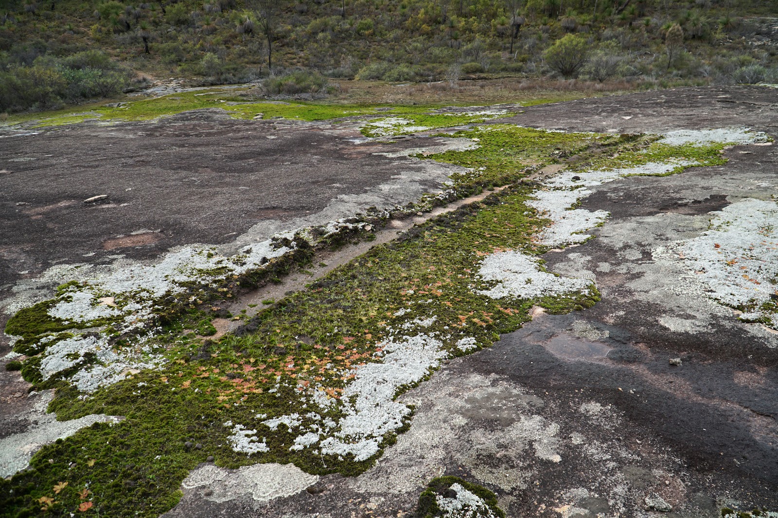
After crossing a vehicle track, Alissa and I were at the base of Abyssinia Rock admiring the moss and water filled gnamma holes across its surface.

Unlike the Sullivan Rock spur trail, the Bibbulmun Track merely skirts the edge of Abyssinia Rock, however a cairn at the high point of the rock is regularly visited as a short side trip. This is about as far as most people go, however Dave’s route takes walkers onwards to explore the full extent of Abyssinia Rock.
Unfortunately, Alissa and I saw some evidence that low impact off-track hikers are not the only ones going out exploring in the area, with tyre tracks from four wheel drives visible at multiple locations along the rock with some thoughtlessly driving over the moss. This immediately made me think of our friend Mark from The Life of Py who is particularly outraged when moss is so carelessly damaged.

The part of Abyssinia Rock most often visited by hikers is separated from the rest of the formation by a thin vegetated strip and there is in obvious informal walk track leading to the other side.

What greeted us on this side of the rock was an even greater expanse of granite with a similar mix of lichens, moss and gnamma holes along its surface. Interestingly, a series of cairns mark a route across the rock. Given the lack of official markers, I think the cairns are a good idea given it probably limits the environmental impact to a narrower corridor, even though it has become very fashionable to indiscriminately hate on all cairns regardless of function. Of more concern to Alissa and I were the number of tyre tracks that were visible across this less visited section of the rock.

Crossing another vegetated strip, Alissa and I were amazed to find Abyssinia Rock extended far further than we had initially suspected, with an even larger section of moss-covered granite leading downhill to even more granite beyond! In the distance we could see the ‘mountains’ of Monadnocks Conservation Park that are a highlight of the Bibbulmun Track just a few days south.

Alissa and I had waited for some significant rains before undertaking this walk so we could see Abyssinia Rock with the moss and water-filled pools that are a signature of the area, however the downside was the slick wetness of the rock which can make for somewhat dangerous walking on granite. Not wanting to disappoint Mark by walking on the moss, we followed the water courses as best we could to get down the slope, with Alissa sliding down some of the more precarious sections.

After crossing another vegetated strip, it was cool looking back across Abyssinia Rock to see the expanse of granite. It is unfortunate that this photo does not have a person in it give a sense of scale, as the rock is absolutely massive compared to what most Bibbulmun Track hikers would experience. We certainly had a very different appraisal now, with Abyssinia overtaking Sullivan Rock for impressiveness.

And yet we were still not done! Like the Star Destroyer at the start of A New Hope, Abyssinia Rock seemed to go on forever (in a good way), with Alissa and I continuing to navigate our way between patches of granite and wet rock.

Following Dave’s route on the ViewRanger app, we continue along the rock by curving to the left to reach a series of large gnammas at the edge of the rock as it transitions back to Jarrah forest.

Looking at the largest and most impressive of these, Alissa pointed out that it had a shape that looked quite a bit like a map of Australia, with a bit of an exaggeration of Western Australia’s size and with the eastern states and Tasmania shrunk significantly in comparison.

From the gnammas, the route descends the rock one last time before rising up a Jarrah-filled slope. The ascent of the slope provides a nice final view back across Abyssinia Rock before continuing along the route.

With the walk having mostly been on track or over easy to follow granite, Alissa and I now had to pay a lot more attention to our GPS tracking as we made our through the forest. While the area had been burnt by prescribed burns in the recent past, the overall quality of the walking on the other side of Abyssinia Rock was quite good for this area, especially since some major bushfires have gone through the area on both sides of Brookton Hwy in the last decade.

After a brief 10 minutes of forest walking, Dave’s route returns to a smaller expanse of granite, because you can almost always count on Dave to define a route that has the most granite outcrops on it. Which, unsurprisingly, is exactly the kind of engaging scenery bushwalkers would want out of walk.

While certainly a lot smaller than Abyssinia or Sullivan Rocks, this smaller granite outcrop had some excellent gammas across its surface and was another charismatic and engaging stretch of the walk.

Leaving the second outcrop behind and thus ending the granite-dominated section of the walk, Dave’s route begins its loop back to the start by heading through Jarrah forest for a more sustain period this time. The Jarrah here has clearly been burnt by bushfire or prescribed burn in recent years, but the overall quality is not bad given the appearance of more mature trees through the area and an abundance of grass trees. The relatively open understory made for relatively easy going off-track walking, which meant we could at least keep a reasonable pace through the forest.

Given that continuous Jarrah forest walking can start to become samey and boring after sustained periods, it was a pleasant surprise to find a flowing creek along the trail with a crossing of the creek required.

Given this area is off-track, there are no bridges or even improvised crossing of the creek and we had to rely on what was already there or get our feet wet. Alissa tested out a log for a potential crossing and found it to be structurally unsound, and instead crossed a bit further downstream at a section of dry, dead scrub that largely kept our boots dry.

About 5 minutes after the creek crossing, Alissa and I crossed a second creek. This one was not flowing at the time of our visit, but with some small pools and puddles along its course, it is possible that it too might be flowing later in the hiking season or after a very wet Winter.

Given that the route was apparently 65% on-track, Alissa commented that it seemed like we’d done an awful lot of off-track walking so far and it didn’t seem to add up. She was delighted then when came upon a short section of single file walking track that appeared to be a part of either the Bibbulmun Track or the Munda Biddi given its well maintained quality.

This didn’t last long, and Alissa was disappointed when Dave’s route didn’t end up following a vehicle track which we merely crossed instead.

On the other side of the vehicle track, Alissa and I found ourselves joining what we realised was a very, very old vehicle track that had been reclaimed by the forest. While it was not immediately obvious, we realised it was a vehicle track given there was a distinctive bulge in the middle of what would have been the track with a slight indent on either side of the bulge. It was really interesting to see a vehicle track so completely reclaimed like this as most seen along the Bibbulmun Track never get to be truly reclaimed because vehicles can still actually use them - and they are regularly used by pig hunters and four wheel drive enthusiasts even when some of these areas are closed to them.

Dave’s route faithfully follows the reclaimed vehicle track and leads to a stand of relatively large Jarrah. This ended up being a key landmark along the walk.

Why? Because on the other side of the stand of tall Jarrah, Alissa and I found ourselves on a vehicle track, with the vast majority of Dave’s route being entirely on-track all the way back to the car. While vehicle tracks are less nice for walking than single file walking track, there is nothing like off-track walking to make you appreciate a track of any description, and it was nice to be able to pick up speed and have some easy going navigation once again.

Continuing on the vehicle track for about 20 minutes, Alissa and I reached a junction in the track and headed right back towards the car.

With Dave’s route following vehicle tracks for so long, Alissa and I almost missed an off-track turn off. After looking at what Dave suggested doing, it became clear we was merely cutting out a bend in the road and there didn’t appear to be some scenic reason for it. Enjoying the easy navigation, we decided to simply stay on the vehicle track as it went the same way anyway.

The vehicle track joins back onto the Bibb, and following the markers northward Alissa and found ourselves back at the car park on Brookton Hwy, having completed the Abyssinia Rock Walk GPS Route.

As with most of Dave’s GPS routes, the Walk GPS Abyssinia Rock Walk was another enjoyable hike in the Perth region that gave Alissa and I greater appreciation of Abyssinia Rock than the Bibbulmun Track did. What we discovered was far more impressive than even Sullivan Rock, and the combination of reward and the relatively easy nature of the navigation given it is mostly on track makes this a Walk GPS route I would thoroughly recommend. This would be an easy project to convert into a completely on-track experience that I would love to see developed in the future, but for now Perth residents chasing the dragon of scenic hiking can at least enjoy what Dave’s put together through a subscription to his site.


0 comments:
Post a Comment