

Day Two of the classic Grose Valley overnight hike in the Blue Mountains, this day of hiking takes walkers from Acacia Flats out of the valley to Blackheath. Leaving the Grose River to follow Govetts Creek, the track leads to Junction Rock before ascending the gruelling but beautiful Rodriguez Pass track to the Grand Canyon. Ascending out of the canyon and following the cliff tops, this is an epic and memorable day in the Blue Mountains
Distance: 13.2 km (one way; includes 2.9 km walk into Blackheath)
Gradient: Continual undulations through the valley, and then a very steep climb out of Rodriguez Pass
Quality of Path: Rough and overgrown in places, although generally easy enough to follow and discern. Some sections where the trail seems to disappear as it passes through water. This is not a dry boot walk
Quality of Signage: Reasonably signed, with some markers and markers at trail junctions. Some creek crossings are not as clearly marked as they could be
Experience Required: Bushwalking experience required
Time: 5-7 Hours
Steps: There are a lot of steps ascending Rodriguez Pass and a few informal steps throughout
Best Time to Visit: Autumn-Spring
Entry Fee: No
Entry Fee: No
Getting There: The walk starts in the Blue Gum Forest and has no direct access. See Day 1 for details on how to get there from Mt Victoria. For those looking to start at Govetts Leap car park or to exit from Govetts Leap, take the turn off Great Western Hwy onto Govetts Leap Rd. The car park is located at the end of the road.

After an enjoyable first day following the Grose River, Alissa and I settled in a cold night deep within valley. With the shorter daylight hours of Winter coupled with being in the bottom of a deep valley, the Sun was already setting at the time of our arrival at Acacia Flat, and the temperatures rapidly dropped overnight. I'm usually someone who does not feel the cold, and while my setup is generally able to withstand the temperatures, my feet were freezing cold when I woke up. At least it didn't rain overnight, and with dry areas to pack up our gear Alissa and I were able to get going faster and with more ease than we did when we woke for our second day of the Royal Coast Track just two days prior.

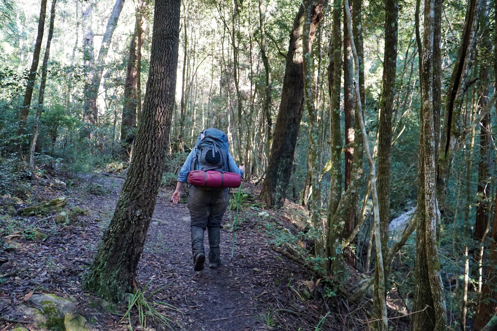
Walking through Acacia Flats after packing, Alissa and I realised it was much larger than we had realised, with a second large camping area and another toilet. Once clearing the campgrounds, the forest of Blue Gums gave way to dense scrub and we crossed a series of shallow gullies feeding into Govetts Creek, with the Grose River veering away from us.

With crisp, cold air, the undulating terrain was perfect to warm us up slightly and I was glad to be wearing my outer shell to keep the heat in at stage of the day. The views down to the creek below were as excellent as we had come to expect from the previous day.

At a broad, mildly eroded section that reminded me of the laterite soils common in Western Australia's South West, the track rose steeply up the valley. In the distance, we could just make out the cliffs of the Blue Mountains glowing beyond through the mist. At the top of the climb was something that had been extremely rare to almost non-existent the previous day - a directional sign point out where we needed to go!

After that first semi-serious incline, the track follows along the high point of the ridge before plunging back down a rocky track. At the bottom, the track passes some informal campsites. Given the close proximity to Acacia Flats, I'm surprised that anyone would opt for one of these informal sites given the significantly better quality of the official campsite.

After descent and informal campsite, the track runs right along Govetts Creek. With the boulders along the river, still conditions and the mist, the view was even more gorgeous than it had been the previous day. As a result, my pace slowed down a fair bit through here as I took photo after photo of this magnificent and wild place.

At times, the route for the track took Alissa and I up and over, presumably because at high water levels a lower route would be impassable. Wanting to stick to the track we duly followed the ascents however we found it very often just returned to a low track. Regardless, the higher sections offered variety to our views and were fairly easy compared to later parts of the day.

While the day was hardly a manicured affair, a narrow, slippery and muddy section of the track right along the river reminded Alissa and I that this was indeed a backcountry-style walk, complete with areas of obvious slip risk without any warning signs declaring it so. It would be interesting to see such signs warning walkers of the arduous nature of walking in the Grose Valley when we joined onto the much more tourist friendly Grand Canyon Walk closer to Blackheath.


After a decent stretch with uninterrupted river views, Alissa and I entered a reedy section through dense bush and overgrown grass which thankfully did not last too long.

Coming out the other side of the overgrown section, the trail opened up to a small flat overlooking the river. Up above, we could see the morning mist beginning to retreat as the view of the classic Blue Mountain cliffs became more visible.

Further along the river, Alissa and I reached a major landmark at a river crossing, which at the time we thought was Junction Rock itself. On the other side of the river, we could see the track to Govetts Leap heading up and away from the main trail. A shortcut out of the valley, Govetts Leap would have cut several kilometres out of our day, however we were following John Chapman's itinerary in Bushwalking in Australia and would instead be taking the Rodriguez Pass up and out of the valley.

The view at the crossing was of an excellent series of small cascades along Govetts Leap Brook, with many small pools forming along its course.

While there were possible dry boot crossing points further to the right, the most obvious crossing point is right across the top of a small waterfall. With somewhat slanted rocks, this could be a potentially slippery spot in wet weather, however Alissa and I were able to get across with ease at the time of our visit.


Knowing that the track to the right led up to Govetts Leap, Alissa and I were not entirely sure which way we had to go to continue along the track to Rodriguez Pass, and initially we stayed on the rocky ledge that runs along the river. As it headed up, the track disappeared and we spent a moment trying to work out where the track continues.

Lowering ourselves down the rocks next to the waterfall, Alissa and I found the track continuing through the bushes beyond.

Just on the other side of the bushes was the real Junction Rock, which is basically located at the meeting point of three water bodies and three trails. From here, Alissa and I turned right to continue on the trail as it made its way up Govetts Creek along the Rodriguez Pass Track.


Given the decidedly poor quality of signage for most of the walk, it was interesting to see a noticeable increase in trail marker quality along this section of the track. Mind you, no one would be mistaking the walking here for the well marked Bibbulmun Track or some of the more tourism-oriented walks in New South Wales, but it was better than the virtually non-existent signage encountered on the first day of the walk.

The walking here was again fantastic, with a mix of walking right by the water's edge and higher traverses looking down to the creek below.

Crossing a side creek, a directional arrow pointed us across the river while a note scrawled onto the sign indicated that yet another trail leads out of the valley at this point. Known as the Horse Track, this trail is a steep and challenging climb that joins back onto the Grand Canyon Walk once it has already left the canyon and is not far off from the car park.

As we made our way along Govetts Creek, we noticed that the vegetation became increasingly lush, and while Eucalypt forest initially dominated, the somewhat untidy-looking dense Eucalypt understory was becoming sparer as ferns and rainforest plants became more common.

Not mentioned in either John Chapman's guidebook or on the map we bought of the area, the walk passed another small campsite just before a series of steps. There are plenty of makeshift campsites along this walk, however what made this one interesting is the fact that stone paving had been put down at some time in the past, meaning this was a more official camping area at one time.

Rising up the stairs, the track again follows a lovely section perched above the creek which offers good views of the water flowing below. At this point Govetts Creek splits into its tributaries of Katoomba and Greaves Creeks.

Descending again, the track crosses Greaves Creek for the first time along a series of natural stepping stones along the creek bed.

While we'd noticed increased lushness early on, this was the major transition point. From here on in, the forest was more of a temperate rainforest that began to look more and more like the Grand Canyon Walk we would be joining onto.

With the added lushness came many more sections carpeted in a dense cover of moss.

The moss here was of the shaggy type Alissa and I have encountered in the rainforests of Tasmania near Pine Valley and in many other forests of that great state, as well as in the subtropical Gondwanan Rainforests of South East Queensland on the Coomera Circuit. The shagginess always seems almost unreal to Alissa and I, and we've often joked that it looks like a muppet that may come to life and starting talking to us.

Following the arrow markers along the track and passing walls of rock along the track, the Grand Canyon feel was definitely becoming more and more palpable as we continued our way up Rodriguez Pass.

While the sound of water rushing along the creek promised waterfalls nearby, a chance animal encounter was a surprise highlight for Alissa and I. Rounding a corner, I was amazed to spot a lyrebird casually walking across the track and then scratching through the scrub for food. Being from Western Australia, Alissa and I had never seen a lyrebird before, with Alissa voicing what we were both thinking - that it looked just as advertised on the NSW Parks and Wildlife logo.

Heading up steps, the track was really beginning to ascend now. The creek was also becoming very rocky, with massive boulders all along the creek, and water cascading down small waterfalls.


As we reached the top of a series of steps, Alissa and I spotted a waterfall reached by a short side trail. Initially thinking it was Beauchamp Falls, we stopped for lunch and to check the guide book. Chapman's book featured a photo of a very different waterfall listed as Beauchamp Falls, which meant we still had a fair bit more ascending to do before joining the Grand Canyon.

Still, at this stage the ascending was not that bad, with the steps being moderate in steepness.

Reaching an impressive series of cascades, Alissa and I were passed by a trail runner who then seemingly disappeared as the trail faded away. We spent ages going all the way to the top of the cascades and tried to work out if we need to scramble up the rocks to follow the creek. After a bit of scrambling it became clear this was not the way to go. Having passed a sign with a walker's symbol pointing us up to the cascades, we knew this was at least the right way, but it just did not make any sense where we were supposed to go given the lack of signage.

Noticing some metal rods sticking out of the rocks along the creek, we realised that we were supposed to cross the creek at this point, with the track continuing on the other side. I was pretty frustrated by the wasted time, but what would come next was not going to help us go any faster.

Immediately on the other side of the creek, the track rises up a series of stairs that were steeper than any we had encountered yet. At this point, I dramatically turned to Alissa and said; "before this day is through, you will know suffering" as I could sense that this set of stairs was just the beginning a gruelling climb.

But before the stairs could really take off, Alissa and I had a brief respite to enjoy a fern-covered wall that definitely brought back memories of the Grand Canyon, as well as the ascent to Barron Pass on the way to Frenchmans Cap.

After the fern wall, the climb basically became ceaseless steep steps for what felt like ages, and often required taking steps that were 3-4 times bigger than was comfortable. Being faster than Alissa, I powered through these while Alissa took her time tackling the steps at her own pace. In hindsight, I probably should have taken it marginally easier than I did as the result of all the steps was a recurrence of my plantar fasciitis issues in the weeks after the walk.

Seeing the way the water was cascading down the creek, I was extremely grateful that we had not scrambled up the creek as there would most definitely have been moments that would have been rock climbing.

The trail levelled out for a bit, allowing for more easy going walking following markers to smaller sets of steps.


Following the markers, the incorrect way appeared like the the most obvious way for me to go. Continuing through, seeing rocks collapsed through a narrow chasm didn't seem right, but the arrows pointing the way made me think this must be correct. Climbing through the rocks it became clear that this was the part of the track that had collapsed and led to the closure of the Rodriguez Pass about a decade ago.

Alissa had found the right way to go and I could see her at the trail above me. Being confident with my scrambling abilities, I decided to climb up the rocks to join Alissa rather than doubling back and squeezing through the boulders in the chasm. I would recommend other walkers not bother with the chasm and just take the proper route instead, both for safety and convenience.

Right near where Alissa had been waiting, a side trail led to Beauchamp Falls. Beauchamp was a beautiful waterfall, even if it was less impressive than the epic Victoria Falls from the previous day. Knowing this was not far from the Grand Canyon junction, I was mostly pleased to know this part of the climb was nearly over.

After some more steps, the track opens up and provides an impressive view of the sheer cliffs of the Blue Mountains. It was cool to see that we were near the top of the vegetated section of the valley just before the cliffs.

The next part of the walk was the only section that had me a bit spooked. The track here has been eroded away to such an extent that the ledge is a narrow, sloping section that required hold onto a cable to get to the other side. This is not that bad, however having an Aarn pack with front balance pockets meant I had to be a bit further out to the edge than I would prefer and it made me realise how these front pockets can be a bit of a hindrance in this kind of terrain. Alissa, who is much more afraid of heights than I am, was unfazed by this section.

Beyond the ledge, Alissa and I entered the section of the Rodriguez Pass Track that clearly was transitioning to the Grand Canyon. While the vegetation and rocks were very similar to what we had already been walking through since two creek crossings ago, the walls were beginning to enclose us on both sides, much as it does along that classic Blue Mountains day walk.

Crossing the creek once more, the relatively flat track made for excellent and enjoyable walking which allowed Alissa and I to really enjoy the landscape we were walking through.


The last few hundred metres of this section were really breathtaking, as we realised we were well and truly in the narrow section of canyon leading to the steps out of the Grand Canyon.

As we rounded the corner, the appearance of a NSW Parks and Wildlife sign indicating we had joined onto the Grand Canyon Walk was a sight for sore eyes (and feet). The sign behind Alissa was the aforementioned warning sign indicating that the Rodriguez Pass and Grose Valley in general was a rough and difficult area for walk, no doubt to scare away tourists from unwittingly finding themselves in the Grose Valley without the right gear or experience.


Last time we were here, I took a photo of Alissa looking very unhappy about having to climb up a series of steps, however with this being known territory and with the end being almost in sight she was a lot more enthusiastic this time.

Had we not had such a long and arduous climb out of the valley, I would have liked to have gone an explored the main part of the Grand Canyon again, however it must be said that the climb out of the canyon features great scenery in its own right.


It is however a continuous series of steps, and as with anything that is hotly anticipated, it seemed like we'd never get to the top as every corner turned seemed to lead to even more steps.

Finally out of the valley, the track leads to a broad rocky flat clifftop that provides views of the Blue Mountains cliffs. To the right of the photo is where the Horse Track joins back onto the main track, and it looked like a very steep and even more unrelenting track.

Cruelly, the ledge is not the end of the climbing as there is still more steps to go to reach the car park at Evans Lookout.

Alissa and I were delighted to have reached Evans Lookout again, and we took the opportunity to look down at where we had come from. Alissa pointed out that where the river was is where we had been earlier today. The photo above does not do justice to it; standing where we were, the distance from the valley floor to the cliffs was massive!

While at the lookout, we spotted a very playful and tame rosella foraging for food. Given the regular tourist numbers to the area, the bird was completely calm and easy going, allowing us to get fairly close as we took photos and videos.

Passing the old rock shelter near the car park, Alissa and I may have successfully exited both the Grose Valley and the Grand Canyon but we still had a lot more to go.

Following a linking trail along the car park, Alissa and I made our way to the Clifftop Walk. When we were last here in 2015, I had wanted to walk the Clifftop Walk to the Grand Canyon, however due to Alissa's back being pulled out we had to shorten it to just the Grand Canyon Walk and a short visit to the northern end of the Clifftop Walk. This stretch then was a bit of unfinished business that was nice to tick off.

The Clifftop Walk is a popular walk in the Blackheath area as it provide stunning views of the Grose Valley below with the mountains rising up and towering overhead.

The downside of the track is that there is still a fair few more steps to go. While less steep than the climb to Beauchamp Falls or out of the Grand Canyon, we were a bit over steps by this stage.

Thankfully, the track does even out to more gentle undulations which allowed us to enjoy the views with relative ease.

Although more steps did bring our mood down again.

Reaching a lookout point near Govetts Leap Falls, Alissa and I had reached this point on our first visit to the Blue Mountains so we knew it wasn't far to the Govetts Leap car park.

After the lookout, the track descends to a bridge over the top of Govetts Leap Falls.

The view of the top of the falls definitely brought to mind the view from the top of Victoria Falls the previous day as well as the waterfalls of the Twin Falls Circuit in Queensland that have similar stunning views from the top of waterfalls.

Reaching Govetts Leap Lookout, Alissa and I took a moment to take in the grandeur of the valley one last time.

This is the end of the trail per se, but having missed the bus at the visitor's centre, we now had the easy but unexciting 2.9 kilometre walk back into to Blackheath ahead of us.

Thankfully, while we arrived late in the afternoon, we got there in time to pop into the Bakehouse on Wentworth for a 10 on a Plate (sausage roll and pie). Alissa and I had been impressed by the pies in Katoomba when we were here in 2015 and these were if anything even better and were a great meal to celebrate the end of our multi-day hiking for the trip.
Of our four days of multi-day hiking in New South Wales - first on the Royal Coast Track and then through the Grose Valley - this was by far the hardest day given the 700 metre vertical gain over the day, with 500 metres of that gain occurring in less than 2 kilometres. Comically, John Chapman classifies this as a medium walk, which is true if West Arthurs and Federation Peak are at the extreme end of the scale, but most people we mentioned doing Rodriguez Pass to used adjectives like 'tough' or 'challenging'.
In spite of the challenge (or perhaps because of it), this was the most memorable day of all four as the relentless climb was tempered by some of the most magnificently wild landscapes of the trip. From Junction Rock onwards, the scenery was very much like a longer, wilder version of the Grand Canyon Walk filled with waterfalls, continuously flowing creeks and lush rainforest. While it is less user-friendly than the Royal Coast Track and as such less easy to unreservedly recommend to everyone, this was one of the best hikes of the year so far. Hikers who enjoy spectacular tracks with a greater sense of wilderness and challenge will definitely savour the Grose Valley, and the Rodriguez Pass in particular.


0 comments:
Post a Comment