

A lengthy (though incomplete) rail trail in the Shire of Denmark, the Denmark-Nornalup Heritage Rail Trail links Nornalup with the shire's main town of Denmark and then to the shire's eastern boundary. Starting at the former Nornalup Station, the trail passes through a delightful mix of farmland, plains and Karri forest. A trail with a lot of potential, a missing section that necessitates road riding is all that's holding this back from being a great riding experience
Distance: 73 km (one way, including road riding to link through the missing section)
Gradient: Mostly gentle with some minor climbs and descents
Quality of Path: a mix of single track, rail trail and repurposed vehicle track. Some sections are quite overgrown and waterlogged in Winter
Quality of Signage: Mostly well signed at all trail junctions, though signs are often behind bushes. No informative trailheads at either end or in Denmark
Experience Required: Mountain Biking or Bushwalking experience recommended
Time: 5-7 Hours on a bike. 2-3 days on foot
Steps: None; this is a dual use trail
Best Time to Visit: Mid Autumn - Late Spring
Date(s) Completed: 12th June, 2021
Best Time to Visit: Mid Autumn - Late Spring
Date(s) Completed: 12th June, 2021
Entry Fee: No
Getting There: The Trail starts on Station Rd or the Hay River. From Denmark, travel along South Coast Hwy for 55.8 kilometres before turning left onto Station Rd. continue on Station Rd for about 2 kms to reach the western terminus. To reach eastern terminus, head east on South Coast Hwy for 10.9 kilometres and turn left onto Pratt Rd. Trail start is where the old rail bridge used to be
Getting There: The Trail starts on Station Rd or the Hay River. From Denmark, travel along South Coast Hwy for 55.8 kilometres before turning left onto Station Rd. continue on Station Rd for about 2 kms to reach the western terminus. To reach eastern terminus, head east on South Coast Hwy for 10.9 kilometres and turn left onto Pratt Rd. Trail start is where the old rail bridge used to be

When my in-laws made the sea change and moved to the Great Southern, they were quick to point out that they lived close to the Denmark-Nornalup Heritage Rail Trail - a walk, cycle and (partially) equestrian trail in the Shire of Denmark that makes use of the old rail form that once linked the small town of Nornalup on the Frankland River to the shire's main settlement of Denmark. While my in-laws have lived in Denmark for almost a decade, the Heritage Rail Trail has well and truly been on the back-burner given the distance to complete the whole trail is not really walker-friendly, and there is a complete middle section of the trail that was never completed. Not exactly the most inviting trail experience on paper.
After riding parts of the trail on the Munda Biddi, my interest in the trail was definitely piqued. I really enjoyed the section I rode, particularly the diversion heading into Denmark. Given the somewhat boring riding along Break Rd on the Munda Biddi, I was also intrigued to know why the Munda Biddi did not use more of the Denmark-Nornalup Heritage Rail Trail.
Down in Denmark for the weekend for my brother-in-law's going away party, I had the morning free to go check out the trail. Given Alissa's parents live just east of Denmark, it made sense to start at the Nornalup end as I could easily ride back to the house after finishing the trail. The trail starts in the middle of no where on Station Rd, however I wanted to start at the Nornalup foreshore given it has spectacular views of the Frankland River. Alissa and I enjoyed the glassiness of the water before we parted ways, with Alissa heading back to her parents' home while I continued out from town to the actual trail start point on Station Rd.

From Nornalup, I left town via South-West Hwy before taking a right turn down Station Rd. With no indication that the Heritage Rail Trail even existed in town and no helpful road signage pointing towards a trailhead on Station Rd, I was wondering what I would discover at the trail's start point. I was relieved to at least see one of the trail's iconic Bibbulmun Track-like orangey-red wooden signposts, however it was a bit disappointing that there wasn't a more informative sign at the start of the trail that would give a prospective rider a sense of what to expect from the trail experience.

At least the historical aspect of the Denmark-Nornalup Railway was taken care of, with a plaque commemorating the closure of the railway line in 1957. The line only operated for just shy of 28 years, but it would be responsible for the route of the entire day's riding.

From the trailhead, the Heritage Rail Trail commences its journey to Denmark by initially following Station Rd. Whether the road replaced the railway line or whether it ran adjacent to Station Rd is not clear, however it provides and easy if not exactly exciting start to the ride.

Crossing Conspicuous Beach Rd, the trail leaves the broad road and continues along what looks to have become a narrow vehicle track.

A couple of minutes after heading along the vehicle track, the firm ground gives way to some horribly soft and unrideable sand. Even with relatively wide tyres and the extra torque that comes with riding an electric mountain bike, there were a few sections I just couldn't get any traction and had to push - something of a rarity as the electric bike can chew through terrain that a conventional bike would struggle with. This is definitely an area where a fat bike would be the superior technology.

Thankfully, the sandiness does not last very long and I was glad to finally be on a stretch of trail that was unequivocally on a rail form, with the Heritage Rail Trail passing through what was clearly an old rail cutting. With firm, compacted ground, this made for enjoyable, easy riding.

Unfortunately the easy riding did not last long. Following straight along the rail form/road, I noticed a sign hidden behind an overgrown bush that indicated that the Heritage Rail Trail was to take a right turn and then follow along a power line road. The overgrown bush covering the sign was definitely a harbinger of things to come as the trail ahead was overgrown and basically riding through puddles and rivulets at the time of my ride in mid June. The water was not so bad, but the fact the trail was so poorly maintained was a definite disappointment.

After riding through many a puddle and getting drenched from brushing up against wet bushes, it was a pleasant surprise to get off the overgrown trail and onto well made boardwalk. While boardwalk of this kind is quite common in Tasmania, it is a rarity on Western Australian trails and felt like a bit of a luxury. It did make me wonder why the boardwalk didn't start earlier, as it surely must have been waterlogged even when they constructed the original trail.

Off the boardwalk, the trail veers to the right and passes a familiar old friend - a Bibbulmun Track Waugal. This is a section of the Bibbulmun Track between Giants and Rame Head that runs concurrently with the Denmark-Nornalup Heritage Rail Trail, and is arguably one of the Bibbulmun's best and most varied days. I walked this section first in 2003, so that would have been my first engagement with the Heritage Rail Trail though I probably wasn't paying that much attention to it at the time. At this point the trail experiences a dramatic change in scenery as it transitions to the spectacular Karri forest that the region is known for. One of the positive side effects is that the fallen leaves from the forest make for a nice and soft riding surface that is a pleasure to cycle on.

The Bibbulmun and Denmark-Nornalup Rail Heritage Trail run concurrently for only about five minutes before the Bibb turns left to cross South West Highway near the site of a place known as Mark's Siding. The Railway Heritage Trail continues straight ahead following the well defined rail form.

With the Bibbulmun Track well maintained by their volunteers, it was obvious that the Denmark-Nornalup Heritage Rail Trail gets far less attention as the trail ahead was basically a continuous corridor of twigs and collapsed bushes. This was a constant stream of twigs being thrown into the air and occasionally have to stop and slowly negotiate some of the tougher obstacles.

While mostly small obstacles, there were a couple of much thicker branches right across the trail including the one pictured above. Given the wet conditions, the smoothness of the branch can be a bit of a hazard to ride over as your wheel can easily slip on it. I decided to pull over and move the branch to one side to make it easier for other riders coming through in the future.

Way beyond my capacity to help was a small tree that had fallen right across the trail, and while not chainsaw territory really required a pruning saw and a lopper to clear. This was the point where riding an electric bike is not an advantage at all as I had to carry the heavy beast through the bushes and through to the other side.

Emerging out of the forest, the rail form has been taken over by the unsealed Benson Rd as it runs through one of the more open and sandy sections of the forest. This stretch lasts a couple of kilometres before the rail form veers off the road as it reenters the Karri forest.

This stretch is one of the trail's highlights as the rail form skirts along the edge of a dam on the neighbouring private property. The karri forest reflecting on the absolutely still water of the dam's water made for a spectacular scene, and I stopped for a few minutes to take it all in.

Not long after the dam, the Railway Heritage Rail Trail reaches Peaceful Bay Rd. At this point, there is a section of trail that has never been completed and it requires a bit of road riding. Given the lack of markers, I really needed to check the map a bit more carefully as I foolishly took a wrong turn and headed right along the road, and would not realise my mistake for at least five kilometres.

While this was the wrong way, it at least wasn't a complete waste of time. There's a day use area along the road that provides lovely views of the Irwin Inlet that I wouldn't say was worth the diversion but was worth checking out considering the mistake I had made.

The farmland scenery was equally lovely as well, with swans walking across the flooded grassland set against a backdrop of tall Karri forest. I continued cycling for quite some time after the swan sighting. The first clue I had made a mistake was passing Ficifolia Rd, which I remembered from the Bibbulmun Track but couldn't quite place in relation to Peaceful Bay Rd. My mistake was confirmed when I saw the sign for the Peaceful Bay tip, which I knew was only a short distance from Peaceful Bay itself due to the fact the Bibbulmun Track inexplicably goes right past the tip!
All up, I wasted about 10 kilometres going to the tip and back, which had me a bit concerned; I had been extremely confident my 500 watt battery was more than enough to get me all the way to the end of the trail (given it has consistently delivered at least 75 kilometres of range when riding trails) that I didn't pack a spare. Given the trail was quoted as being 54.5 kilometres, 64.5 kilometres was still well within the estimated range, but little did I know at the time that the entire ride was more like 73 kilometres.

Finally back at the point where I had taken a wrong turn, it was only a short ride to the end of Peaceful Bay Rd and onto South Coast Hwy. The official brochure for this trail says that 'the 14km section between Parker Rd and Bow Bridge is not expected to be open for a few years, once bridges over the Kent and Bow Rivers have been re-built', and this has been replicated in Trails WA's advice. Given that the trail construction began in the 1990s and would have been completed sometime in the early 2000s, 'not expected to be open for a few years' seems to have become 'not expected to be open ever', and given the lack of maintenance along the trail suggests there are not enough people agitating for this to become a reality. Due to the lack of trail here, riders are forced to ride along the highway, which unfortunately happens to be National Highway 1! The result is riding with cars speeding past (some towing caravans) and in sections with 110 kilometre speed limits. As someone who is not a road biker I find this a bit disconcerting, and is something that I think the family friendly kind of riders that rail trails are perfect for would not be comfortable riding.
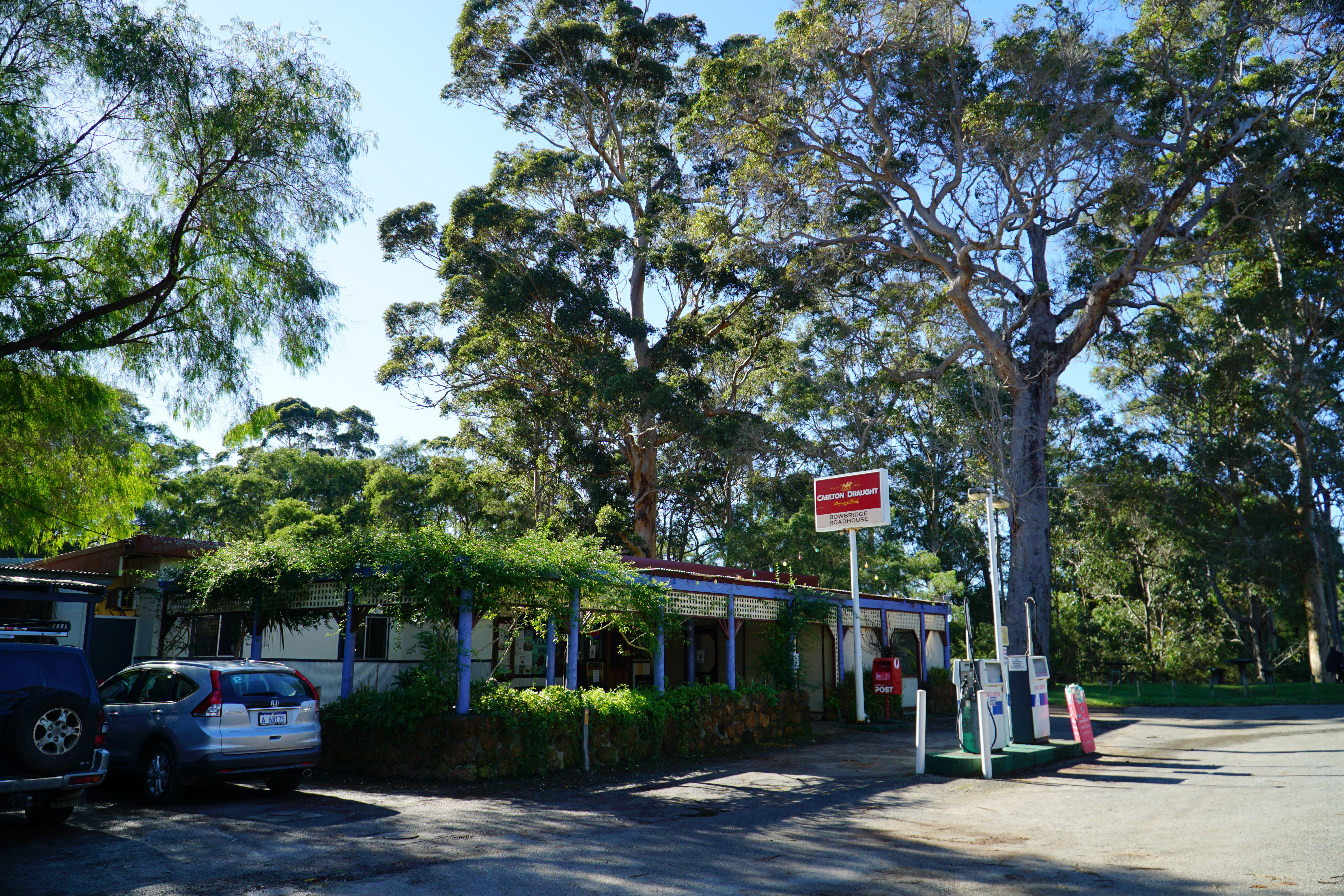
500 metres from the Peaceful Bay Rd turn off is Bow Bridge Roadhouse which Alissa and I have stopped over at a few time since they have pretty good roadhouse food and a surprisingly good wine selection in their bottle shop. Being a bit flustered from taking the wrong turn and now riding on the road, it was great to be able to stop over, getting a nice bottle of juice and an apricot and coconut slice for an instant energy replenishment before heading back out on the road.

Just before entering the 110 kilometre speed zone, one of the few highlights of the road riding is riding past the Bow Bridge Deer Farm. Venison is still quite rare in WA, so the sight of deer out in the field instead of cows or sheep is quite a nice surprise.

When riding along the highway, one of the major landmarks on the south side of the road is Mehniup Hill - a massive granite formation protected within Mehniup Nature Reserve. When you look at where the old railway went, it would have passed right near the granite hill, and I see this as a classic example of the missed opportunity of this unfinished trail.

Keeping my head down and just riding out the kilometres, I was glad to reach Kent River. Kent River offers fresh produce for sale, and used to be one of the few places you could buy Marron relatively easily in the Great Southern for many years. There even used to be a Big Marron sculpture on display, but this has since been removed and replaced with a rusty vintage car instead.

700 metres from Kent River, I was glad to finally reach Parker Rd, which marked the end of the awful 10 kilometres along the highway. All up, the never completed section results in nearly 14 kilometres of road riding to join up the parts that are completed, which means you'll have ridden more along a road by this stage than on actual trail.

Rolling down Parker Rd, it can be easy to miss the sign to the right as the rail form reemerges once again, and I was grateful to finally be back on (a) track.

While this was a step up from road riding, the same level of neglect was definitely on display along this section of the rail trail, with tall grasses suggesting it has been quite a while since the area had been maintained.

Looking at where the trail goes, it seems incredible that a trail even exists through here as there is a lengthy section that is one farm after another. Yet the form has been reasonably maintained with a number of gates providing a right of way for riders and walkers. Being early winter, there were a lot of soggy, waterlogged sections of the trail that were actually quite fun in their own squelchy way.

While mostly pleasant rather than spectacular, one 'highlight' of this section was a massive twig that got stuck in my wheel. Having ridden the Munda Biddi, this sort of this happens all the time and I didn't think very much of it when it happened. It would not be until the next day while riding a section of the Munda Biddi that I realised that the stick had actually broken one of my spokes!

After passing through a few more pastures and spooking a few young cows that had wandered onto the rail form, the trail gets into a rhythm as it continues along the overgrown rail form. While the trail's signage is actually very good, the biggest issue for users of the trail is that way too many of the signs are hidden behind bushes that have grown too dense in places.

While having a few turns in places, the trail becomes extremely straight, and remains so for some time.

The straightness thankfully does not become monotony as this stretch of the track is gifted with three rail bridges of increasing excellence. The first of the bridges is a relatively low key and short wooden bridge. The wood of the bridge is slightly higher than the sandy soil of the rail form, however the long wooden boards that has been placed where the tracks used to be have had their edges cut on an angle and thus allows a bike to roll up and over.

Beyond the first bridge, the apparent straightness continues, however there is a change of scenery as the rail trail heads through an obvious cutting. At the time of my ride, the cutting had turned into a bit of a stream, with sustained sections of riding that were through continuous puddles. Some were surprisingly deep, and made for some fun surprises as the puddle riding turned into a splashdown.

The second rail bridge is a more substantial structure than the first, which is unsurprising given this bridge crosses the Kordabup River as it makes it way down to the Parry Inlet. This time the form and bridge were more evenly levelled. While I didn't have a tape measure handy to check, this appeared to be the longest extant bridge of the Heritage Rail Trail.
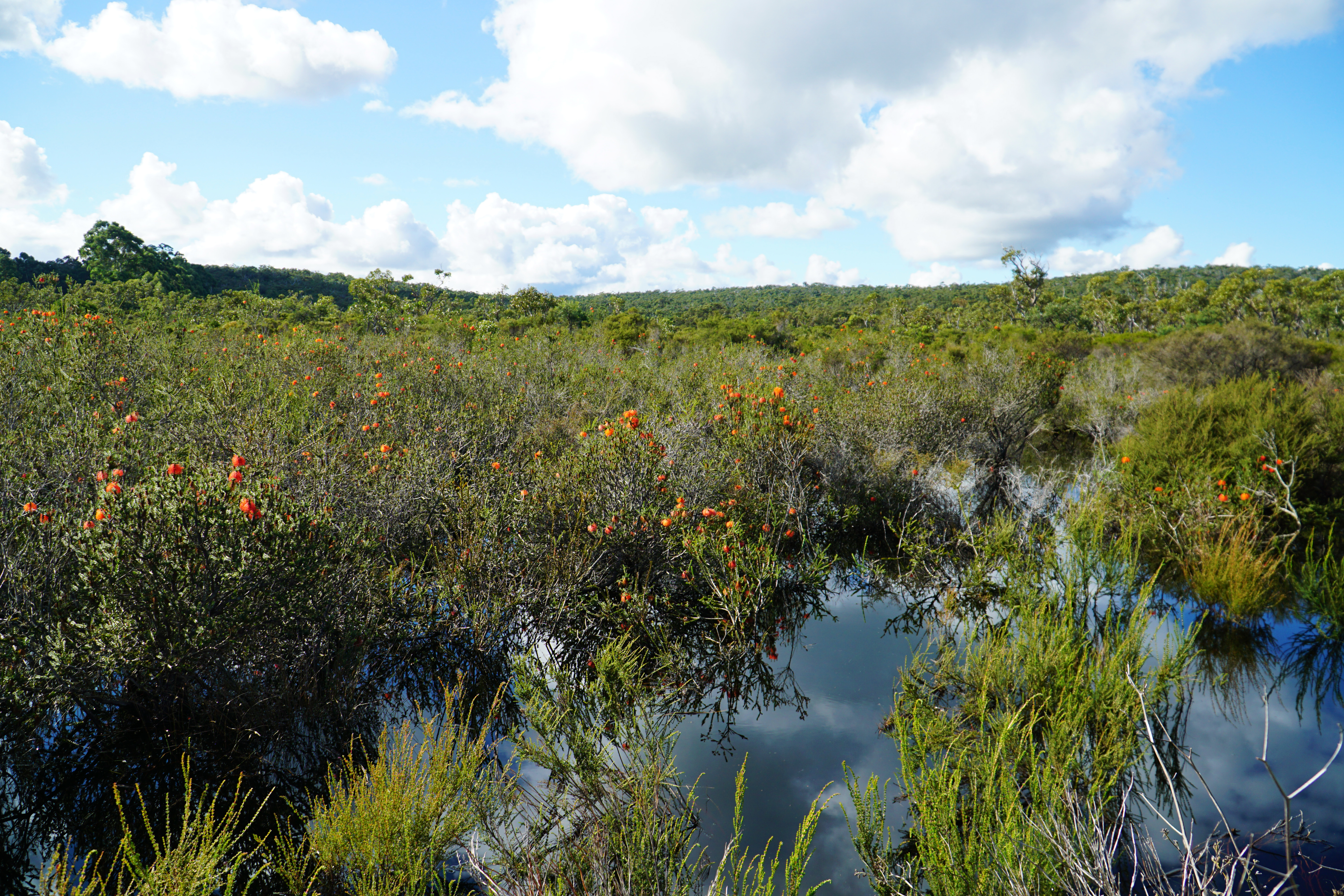
Crossing the bridge, the trail entered a swampy area that was easily one of the most spectacular moments of the ride. Completely inundated, the wetlands were filled with the most spectacular profusion of swamp bottlebrush I've ever seen. Having walked the Pingerup Plains section of the Bibbulmun Track in April, I knew that swamp bottlebrush generally flowers from Autumn and then again in Springtime so I was thus very surprised to see them blooming in such profusion at the start of June. The scene was so spectacular I decided it was the perfect place for a rest spot as I ate the rest of the apricot and coconut slice I had bought earlier in the day at Bow Bridge.

The third rail bridge is easily the most characterful of the lot; located in the shade of forest and lined with ferns, the more closed appearance makes it a lot more lush and interesting compared to the first two while also being of a decent length.
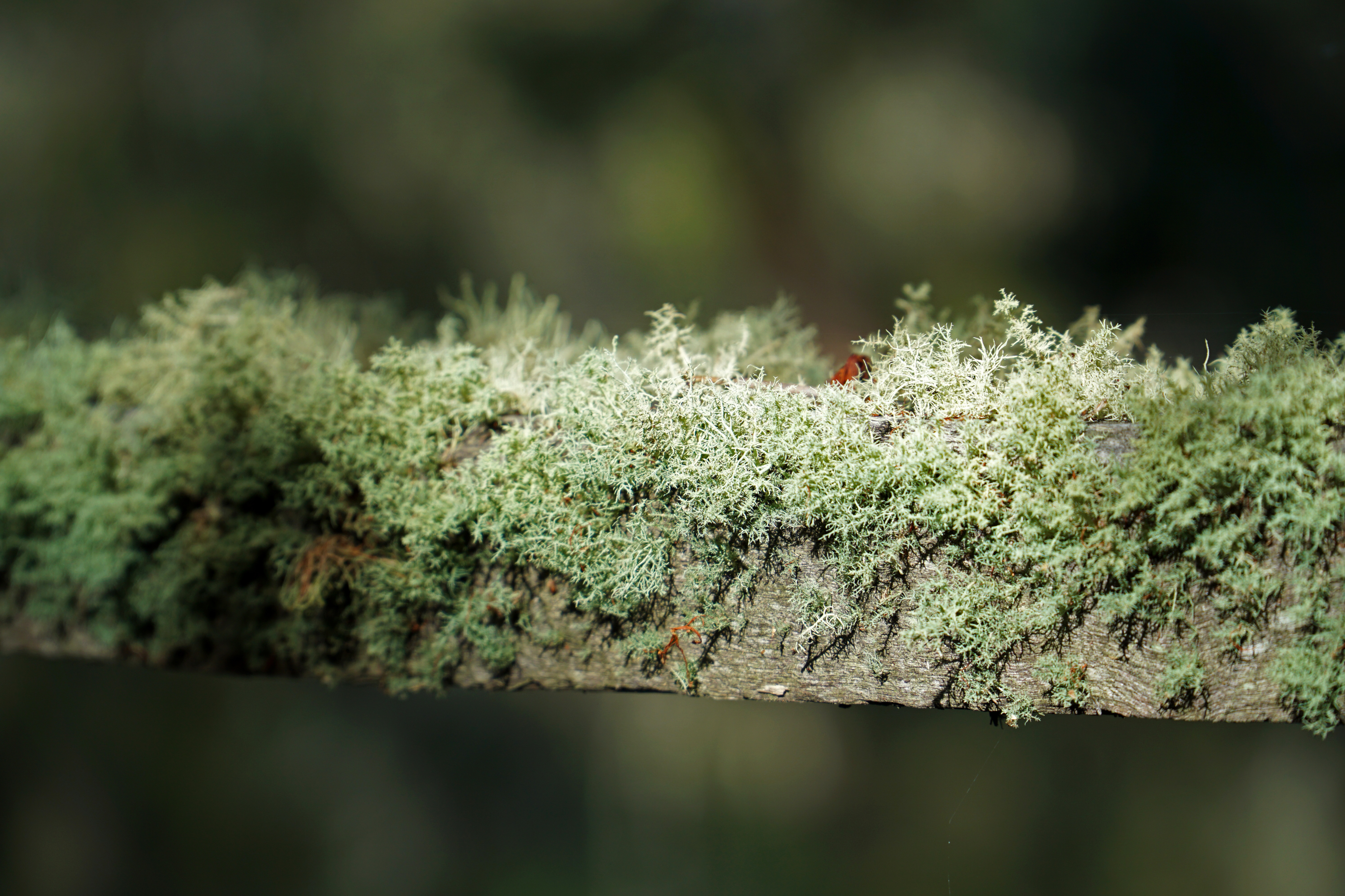
One of the coolest aspects of this bridge is that the wooden railings on either side are covered in a layer of lichen, giving the bridge a shaggy green jumper appearance that is only possible because of the cool, shaded nature of the bridge's location.

Beyond the third bridge, the trail's level of maintenance looks much better than it had been for the entire ride. Instead of overgrown grasses, bushes and fallen trees, I was greeted with fairly well maintained trail that suggested this was a much more well used part of the Rail Heritage Trail. Signage was still sometimes a problem given many signs were hidden behind bushes, however it was still much better than most sections further west.

Given the improved trail maintenance standard, I was anticipating that I would soon be joining the stretch of the Denmark-Nornalup Heritage Trail Trail that is shared with the Munda Biddi. Reaching Limbourne Rd, I was elated to see the familiar sight of a yellow Munda Biddi marker post as I turned onto Dunster Rd. Dunster Rd basically runs through where the old railway line used to go however it has become an exceedingly wide stretch of road riding.

Thankfully the road riding doesn't last too long, and it leads to another one of the trail's best moments as it follows a curving section of raised form lined with Karri forest and shaded farmland on either side.

At McLeod Rd, the Munda Biddi and Denmark-Nornalup Heritage Rail Trail part ways again, with the Munda Biddi heading south towards William Bay National Park while Heritage Rail Trail continues along the old form. The form enters a fairly sodden cutting referred to as the Henderson Cut that has a nice, lush and dense appearance.

Crossing South Coast Hwy once again, the trail takes on another transition in scenery as it passes through a mix of low forest and farmland that is easy going while being quite engaging.

The highlight of this stretch of the trail is what would have been the fourth rail bridge crossing of the trail, but has unfortunately since fallen into disrepair. When I rode this section while following a diversion on the Munda Biddi, there was a temporary bridge across the creek however a more permanent concrete structure has been put in place.

When I rode past the bridge last year, I had commented that it was nice being able to ride alongside the bridge, however I have to say I'm bitterly disappointed by how the bridge looks since its decommissioning. In a bid to complete dissuade people from using the bridge, the Shire of Denmark have removed the side railings that were in place, and while it may be closer to how the bridge may have originally looked, the side railings added some interesting structural shape to the bridge, which now looks a bit bare and skeletal in comparison (see the cover photo for how the bridge used to look).

The iconic rolling green grass of Denmark indicates that riders are getting close to town, with a particularly lovely view of idyllic farmland filled with granite outcrops and cows being very close to the edge of Denmark's residential area.

Crossing Ocean Beach Rd, you really start to feel like you're in town, and indeed turning left at the road will lead to where the Denmark Visitor Centre is located. The Visitor Centre was closed in 2020 but was reopened as a temporary service supported by the Denmark Chamber of Commerce and run by volunteers. Based on the somewhat tenuous nature of the setup it is probable best to not rely on it. Sticking to the trail however, it is amazing that the rail form passes through an area of native bush that remains largely undeveloped and feels a world away from the (relatively) busy main strip of a tourism town in spite of being just a few hundred metres away.

Joined by the Bibbulmun Track, the Railway Heritage Trail passes through the old Denmark Station which has been converted into a bit of a heritage display. As a rare treat, there is even a section of the old railway line that is still place which provides a sense of what the line would have looked like.

Passing some old rail cargo cars, the trail crosses Hollings Rd as it reaches the southern end of the Denmark River's foreshore precinct. Across the road is the Denmark trailhead for the Bibbulmun Track, which oddly enough is not located closer to the town centre. For those looking to head to the main street, the Mokare Heritage Trail offers an easy and idyllic path along the river foreshore and is well worth checking out in its own right.

In spite of reaching Denmark itself, the rail trail actually continues eastward and heads towards the eastern border of the Shire of Denmark. To cross the Denmark River, an impressive rail bridge has been converted into a pedestrian river crossing and is also a major feature of both the Mokare Heritage Trail and the Munda Biddi, which once again runs concurrently with the Denmark-Nornalup Heritage Rail Trail.

Having crossed this bridge several times in the past already, I was perhaps a bit blasé about the experience as I declined the offer from a couple of walkers to take a photo of me on the bridge.

On the other side of the river, things get really interesting as it is the start of the Wilson Inlet Heritage Trail, meaning for a brief moment people on the trail are on the Mokare Heritage Trail, Wilson Inlet Heritage Trail, Denmark-Nornalup Heritage Rail Trail and the Munda Biddi! The Wilson Inlet Heritage Trail is basically a subset of the Denmark-Nornalup Heritage Rail Trail that would have come about thanks to the 1988 bicentennial celebrations which basically saw funding available for any trail as long as you put the word heritage into the name. I sometimes disparage these trails as 'I gave up halfway!' versions of the longer trail and a bit disingenuous when they are double counted towards a state's trail supply, but I suppose the bicentennial origins of the Wilson Inlet Heritage Trail would mean it greatly predates the Denmark-Nornalup and it would be a bit unfair to the earlier trail for its identity to completely disappear.

A feature that is peculiar to the Wilson Inlet Heritage Trail section of the ride is the provision of a series of shelters along the way. These shelters have often captured the imagination of Bibbulmun Track hikers as there are often questions about whether they can be stayed at as a way of making the Bibbulmun Track a continuous trail all the way around the inlet. Unfortunately, the reality is that only the first of these shelters is in good condition and there really is no space within to set up a mattress and sleeping bag. Some of the ones further along are in terrible shape, with one having its entire roof chopped off! These shelter are however worth visiting from a birdwatching perspective as they provide idyllic locations to enjoy the native flora and fauna of the Wilson Inlet.

Continuing along the trail, there are some nice shaded sections through obvious rail cuttings, and while the forest is a bit on the scrappy side the higher sides give it the more enclosed feeling of more mature forest.

A highlight of the Wilson Inlet is Springdale Beach. Prior to the 'discovery' of the vastly superior Greens Pool by the European settlers, Springdale Beach was the main beach in the area and remains an attractive looking spot along the Wilson Inlet. The skeletal remains of an old jetty speak of the area's greater importance in the past, however the area can have a bit of a sulphurous smell for most of the year. With all the recent rain, it was no where near as smelly as it was the last time I was here around Christmastime - though I can't say the cold weather inspired me to go for a swim.

When I rode this section as part of the Munda Biddi, I had spent so much time visiting the shelters (you can see from that write up that I visited many more of them), and when it came to the Springdale Tunnel I just didn't feel like I had the time to go investigate. When I was here in December, I took the opportunity to check it out and was able to actually walk into the drain. With the recent rainfall, the water level was considerably higher and tunnel mostly flooded.

Springdale Beach is close to where my in-laws live, and I had considered making a side trip off the trail to go get my spare battery. Due to going the wrong way at Peaceful Bay and the underquoting of kilometres on TrailsWA's website, I was dangerously close to running out of battery on the bike. Given I find the bike tends to be a bit pessimistic about range, I thought that maybe I'd be alright so decided to continue through one of the nicest forested sections along the Wilson Inlet.

Given there are some swampy sections on the other side of the trail, the Shire of Denmark looks to have added some additional drainage to the trail. As part of their construction work, they look to have pulled out a series of railway sleepers in order to put the drain in. It is fascinating to think that instead of ripping up the infrastructure they just covered it up and compacted the ground, and it made me wonder what happens when the wood rots out...

Reaching the end of the Wilson Inlet Heritage Trail, the rail form disappears and gives way to Rudgyard Place. When I rode the Munda Biddi, I followed the signage with takes cyclists along the road while the Heritage Rail Trail turns off to the left along the fence line along the farmland. Looking at the slightly overgrown grass, the trail didn't look particularly inviting at all but I decided that I wanted to do the trail in its entirety as it was meant be done so pressed on. The photo above is from the first few metres, and it got a lot worse as I kept going. The trail became non-existent as it turned into disconcertingly high grass, and even worse became a completely sodden mess. I couldn't stop at all as it meant putting my foot down on waterlogged tall grass, and I couldn't escape the trail to go back onto the road as it meant heading through similarly disconcerting tall grass.

Feeling the extra effort of cycling through water drastically draining my battery energy, I was glad to be out of the sodden tall grass as it crossed Rudgyard Rd and back onto distinct rail form through a cutting.

After being a bit annoyed at the overgrown grass, I was glad to be on a well manicured stretch of trail thanks to being part of the Munda Biddi. This section features a welcome return of Karri forest, albeit of a fairly young regrowth variety. At this point, my battery situation was looking pretty dire and I realised I'd made a huge mistake not turning off to get the spare battery.

Leaving the Karri forest and passing some farmland, the Denmark-Nornalup Heritage Rail Trail crosses South Coast Hwy one last time, and not long after crossing the road my battery ran out completely. The trail from here to the trail end is fairly unremarkable given part of it is along powerline and service roads.

After reaching the end of the trail, I still had to ride back to my in-laws' place, which meant a rather awful 10 kilometres along the highway peddling a rather heavy bike up a few hills while cars sped past, and I was glad to be done when I got to their place, feeling way more shattered because I had made the wrong turn and had prepared myself for far fewer kilometres than I ended up riding.
I have to say that the Denmark-Nornalup Heritage Rail Trail is a trail with so much rich potential and yet so much missed opportunity given a huge middle part of the trail was never completed (and thus necessitates road riding) while the parts that do exist that are not also part of the Munda Biddi are in quite a terribly poor state of trail maintenance. Which is a real shame, as there are some really fantastic parts of the trail like the Karri forest section nearer to the Nornalup terminus, the swamp bottlebrush and rail bridges of the middle section, and the lovely riding along the Wilson Inlet.
While I know riders do use this trail to skip the three day Walpole to Denmark section of the Munda Biddi as it has its own problems, it is a shame riders have to go along the road when the form would have taken them past a spectacular granite monolith rather than having to share Highway 1 with touring vehicles travelling at 110 kilometres an hour. Furthermore, an improvement to this rail trail would make it a perfect way to create a four day loop on the Munda Biddi, riding out from Denmark to Walpole, and then heading back to Denmark along the Munda Biddi. Hopefully the trail will one day get the funding to be completed, but until then it is a flawed but enjoyable trail that just need a bit of TLC to become the excellent experience it could be.


Hi, Thanks for a great review of the Denmark to Nornalup Rail Trail. I think you mean the Hay River, not the Moore River though.
ReplyDeleteI wish we'd read this before becoming stuck in the tall grass lol
ReplyDelete