

A excellent circuit walk in Mt Buffalo National Park, the Mt Buffalo Circuit explores the rugged granite country, forests and alpine meadows of the park. Generally mellow but occastionally steep, the track features outstanding side trips to three great lookouts at granite peaks. A highly enjoyable if slightly overgrown track, the Mt Buffalo Circuit is a great all day walk for road trippers exploring Great Alpine Rd
Distance: 18.3 km (loop)
Gradient: A mix of gentle, undulating terrain with some steep sections - especially near the granite lookouts
Quality of Path: Relatively clear and straightforward, though some sections range from mildly to severely overgrown - particularly to Macs and Eagle Points
Quality of Signage: Poor quality trailhead. Trail junctions are usually well marked by some are not overly clear. This was is best done with Daywalks Around Victoria by Glen Tempest
Experience Required: Previous Bushwalking Experience Required
Time: 6-7 Hours
Steps: Several formal and informal steps, with some ladders and stairways at the lookouts
Best Time to Visit: Spring-Autumn
Entry Fee: No
Entry Fee: No
Getting There: From Great Alpine Rd and 8.8 kilometres northwest along the road from Bright, take the turn west at the roundabout onto Mt Buffalo Rd. Continue on Mt Buffalo Rd past Lake Catani and Dingo Dell to the bend in the road before the Cathedral. The walk begins at the Macs Point Track sign

Having tackled Eurobin Falls the previous day as our short introduction to Mount Buffalo, Alissa and I woke up on the Sunday to tackle the main event of our road trip - the Mt Buffalo Circuit. Outlined in Glen Tempest's Daywalks Around Victoria, the walk combines a number of tracks through the park to create a relatively easy loop walk that explores the forests and plains of the area.

The walk starts at the Macs Point Track trailhead, located at a bend along Mount Buffalo Road just before the Horn. There are a few spots for walkers to park a car just off the road, however Alissa and I definitely had the impression that this is one of the lesser visited parts of the park given the old school and not overly prominent signage.

Descending from the road, the track immediately offered Alissa and I an excellent view of the Cathedral towering over the grass plains below.

The open plains are fairly brief however, as the track enters a shaded section of forest immediately after. The narrow, single file walking track through here seemed to be quite poorly maintained at the time of our visit, however would represent some of the better maintained when compared with some of the really overgrown walking we would encounter further along.

The trail network through Mt Buffalo seems to be a series of interconnected 'choose your own adventure' options, not dissimilar to the tracks through Mt Field National Park in Tasmania. The signage along the Mt Buffalo Circuit also looked strikingly similar to those seen in Tasmania, with a particularly strong resemblance to the signs seen at Dove Lake or the Overland Track.

The track continuously alternates between sections of forested walking and areas of more open grass plains. Many of the trees through the area show the signs of the devastating 2006 fires, with many skeletal branches reaching to the heavens all along the walk.

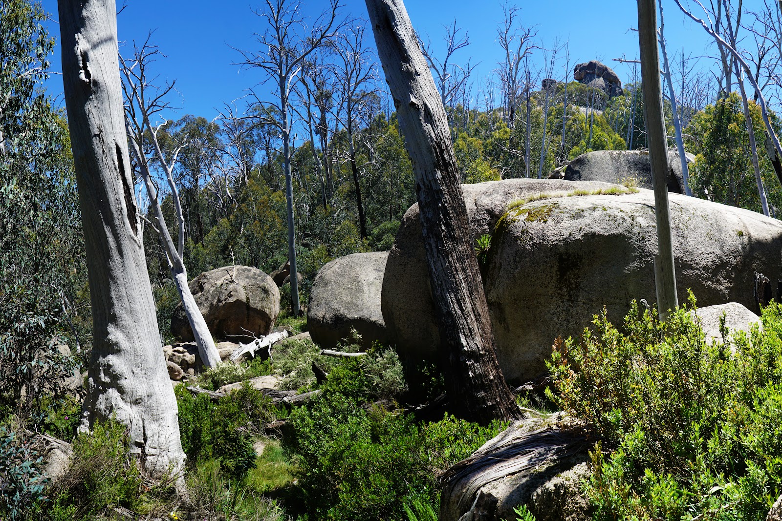
The walk isn't all dead trees and recovering forests however, and there are a number of excellent sections that seemed to have survived unscathed. Alissa and I particularly enjoyed a section that passed through a jumble of massive granite boulders, and reminded us a lot of both the granite-dominated landscapes in Western Australia's South West, as well as Cathedral Rock National Park in New South Wales.

With all the open grassy fields, Alissa and I were keeping our eyes peeled for wombats. Although we sighted a lot of burrow holes and the tell-tale cube shaped droppings of these sweet marsupials, we did not see any along our walk.

As we continued on our way to Macs Point, the track became increasingly rough and overgrown, with a lot of fallen trees across the track. Climbing over one of the trees, I was pierced by a sharp protrusion of splintered wood jutting out from its side which managed to create a nasty gash on the side of my leg. Amazingly, my pants were not cut by the tree and yet the wound resulted in a fairly bloody injury that has left a bit of a scar! I must have hit the tree with some force.

After taking a moment to deal with my wound, Alissa and I continued along the track as we reached the junction where the Macs Point track branches off the main circuit.

Up until now, the track was not well maintained but was easy to follow, however at the time of our visit (January 2019), the track to Macs Point was terrible overgrown and even indistinct in places.

Sections in the more open grasslands were a welcome respite from the more overgrown stretches through forest.

One of the forest sections was so bad that it was unclear exactly where we were meant to go, and we had to stop for a second and look a bit beyond our immediate location to discern where the track was meant to be.

The slightly challenging nature of the navigation was however amply rewarded by the views at Macs Point. From the granite outcrop, Alissa and I could see across the valley to the Horn, Cathedral and the Hump. While the guidebook suggested we would be able to appreciate how severe the fire had been from this vantage point, Alissa and I felt that the overall scene was a lot greener than we had expected, and it was the more immediate scenery right along the trail that revealed just how many Snow Gums had been burnt by the ferocious fires.

Heading back from the Macs Point side trip, Alissa and I followed the track towards Reservoir as it passed through some more open grassy plains.

These grassy plains were some of the best parts of the walk in a lot of ways. The burnt forest was at times fairly oppressive due to its misshapen appearance, but the plains had recovered quite well by comparison.

While initially following single file walking tracks, the route to Reservoir turns onto a management track that traverses the Wild Dog Plains. Mt Dunn was visible in the distance, however the track would swing in a northwesterly direction away from Mt Dunn to bring us to Eagle Point. The idyllic nature of the scenery was slightly hindered by the annoying number of march flies that continually attacked us. Ah, one of the joys of Summer hiking - even in the high country.

Reached from another side track, the turn off to Eagle Point was not overly clear as the sign pointing towards Eagle Point was not at the junction itself but about 10 metres further along the side track and hidden from immediate view behind some bushes.

The side trip to Eagle Point was a lot longer than the short track to Macs Point, and passes through quite a range of landscapes. Initially, the walking is through fairly dense, thin and scrappy Eucalypts but opens out to grass plains and then more mature forests. Along one of the forested stretches, Alissa and I had our one and only snake encounter along the walk, with the snake slithering across the track after I passed through and then being right in Alissa's way. After some tapping of the ground, the snake was back into the bushes and Alissa and I proceeded onwards with an eye out for more snakes (as well as any potential wombat sightings).

Reaching the jumble of rocks at Eagle Point, Alissa and I were about to enter one of the most exciting parts of the Mt Buffalo Circuit as we scrambled our way up the granite boulders to the massive dome in front of us.

Reminiscent of Castle Rock in the Porongurups, Alissa and I climbed a series of ladders to reach the top of the massive outcrop.

The views from the 1490 metre high summit were even better than Macs Point. While several times taller than Castle Rock, the views here really reminded us a lot of the Porongurups, with even the burnt trees being a stand in for the burnt Karris seen from Castle Rock's summit.

Looking back to the south, Alissa and I could see the Horn and Cathedral in the distance.

After taking some time to appreciate the excellent views, Alissa and I began our descent of Eagle Point.


Back along the main track, the circuit one again winds its way to Reservoir via the northern edge of the plateau.

This section is fairly uneventful, and with Alissa and I needing to head back to Melbourne for dinner with friends we decided to skip the optional side trip to Og, Gog and Magog (in spite of really wanting to do it because of the name). Nevertheless, we did enjoy the views from a granite shelf along the northern edge across the valley of the surrounding landscape.


Clearing the northern edge, Alissa and I returned to lovely grassy plains with a number of small lakes located just off the track. At this point we could hear voices on the other side of the hills and knew we were getting close to the Reservoir.

The single file walking track joins onto the Mt McLeod Track as it heads towards the Reservoir and reminded Alissa and I of some of the fairly average vehicle track walking that is commonly seen around the Perth region in Western Australia.

Crossing Crystal Brook, Alissa and I turned right onto the road to Reservoir.

Given that a picnic area appears on the map of the walk and imagining the kind of dam picnic areas commonly seen in Western Australia, Alissa and I were shocked to see the above table and chairs as being the extent of the picnic area at the Reservoir car park! Having saved the area for our lunch, we decided to still stop for a bite to eat before continuing along the circuit.

From the car park, the walk follows another service track towards Mt Dunn.

Along the track, Alissa and I had some views of the Reservoir, which appeared as a large but not overly impressive lake. Initially following the road, the track veered left along a single file walking track as it headed towards Mt Dunn. At this point Alissa and I passed a large walking group that were heading up towards the summit as well.

The track to the summit initially follows a series of steps that zig-zag up the mountain to the granite-dominated summit.

As the track gets higher and higher up, the exposed granite is traversed via a series of solid ladders and stairs bolted into the rock. This is the highest point of the walk and as such the stairs are even more elaborate than the ones as Eagle Point.

At 1510 metres, the views from Mt Dunn were outstanding, and were well and truly the highlight of the entire circuit.

In the distance, Alissa and I could see many of the Victorian High Country's tallest peaks including Mt Bogong and Mt Feathertop's distinctively peaked summit.

Even more excitingly, we were able to look across the scenery below and pinpoint where we had walked earlier in the day. There were times along the walk where the burnt forest and sameness of the scenery had been less than inspiring, however standing on top of Mt Dunn all the boring bits were immediately made worth it for the reward.
Back down from the summit, the track skirts around Mt Dunn in a manner very similar to the track around Cathedral Rock.

Passing one last open plain, the track takes a hard turn to the right as it begins the home stretch walk back up towards the Macs Point Track car park.

The walk up and out is steep and continuous; certainly more than the photo above illustrates. Nevertheless, there were some lovely forested sections that seemed less badly fire damaged along this ascent that were worth appreciating.

Emerging out of the forest at the first track junction we encountered earlier, the sight of the Horn once again was a welcome indication that we were almost done with a short walk being all that separated us from our car parked along Mount Buffalo Rd.
Glen Tempest's Daywalks Around Victoria has been a repeat source of inspiration for walks in Victoria, and the Mt Buffalo Circuit was another enjoyable walk from this invaluable book. While the overgrown and poorly maintained tracks were less than desirable, the ever-increasing quality of the lookout points at Macs Point, Eagle Point and the summit of Mt Dunn more than made up for the track's lesser moments. This is a great full day walk introduction to one of Victoria's oldest national parks, and filled me with enough enjoyment that I would gladly return here for more hiking adventures in the future.


0 comments:
Post a Comment