

A wild and neglected walk in Walpole-Nornalup National Park, the Nuyts Wilderness Track explores an underrated section and varied section of the park. Starting at Deep River and running concurrently with the Bibbulmun Track, the Nuyts Wilderness Track branches off to explore the stunning Thompson and Aldridge Coves. Featuring ruggedly beautiful coastal views, this is an area teeming with untapped potential
Distance: 16 km (loop)
Gradient: Moderate hill climbs along the coastal section but mostly some mildly undulating sandy track walking
Quality of Path: Clear and relatively well maintained trails closer to the start of the walk at Deep River, with vehicle track followed for the rest of the way. Faint bush pads Thompson Cove and the lookout point overlooking Aldridge Cove
Quality of Signage: Fantastically clear Trailhead. Initially follows Bibbulmun markers, but there is no signage from the Bibbulmun junction onwards
Experience Required: Previous Bushwalking Experience Recommended. While most of the walk is on already existing trails, the walk is not marked and follows bush pads in close proximity to the wild Southern Ocean
Time: 4-5 Hours
Steps: Several formal and informal steps
Best Time to Visit: Autumn-Spring. There is a lack of shade and a high fire risk in Summer
Entry Fee: No
Entry Fee: No
Getting There: The circuit starts at a car park on Tinglewood Rd. West of Walpole, follow South Western Hwy and turn south onto Tinglewood Rd. Continue on the road until reaching a car park along the track. Look out for Bibbulmun Track markers nearby as it is not overly clear where it begins
GPX File: A GPX file of this walk is available here. Please note that while all care has been taken to make this file as accurate as possible, by downloading this GPX file you agree its use, and reliance upon, is entirely at your own risk. The Long Way's Better and its writer Donovan de Souza accepts no responsibility for any loss, injury, damage, mishap or inconvenience sustained by anyone undertaking this walk. It is the responsibility of every walker to evaluate the best and safest way to actually proceed
GPX File: A GPX file of this walk is available here. Please note that while all care has been taken to make this file as accurate as possible, by downloading this GPX file you agree its use, and reliance upon, is entirely at your own risk. The Long Way's Better and its writer Donovan de Souza accepts no responsibility for any loss, injury, damage, mishap or inconvenience sustained by anyone undertaking this walk. It is the responsibility of every walker to evaluate the best and safest way to actually proceed

With the weather heating up in Perth, Alissa and I decided to head south to cooler climes and to sneak in another hike in the Walpole area. While our list of places to check out gets shorter and shorter, there are a handful of substantial walks between Walpole and Albany that we've yet to cover. One such example is the Nuyts Wilderness Track. Known to hikers of the Bibbulmun Track who have walked the section from Long Point to Mt Clare, the Nuyts Wilderness has long been something of an obscurity in spite of being over 13 kilometres in length and sharing part of its length with the Bibbulmun. Having been overgrown in recent years due to being an apparent wilderness (it is not, but more on that later), the track was perhaps a little uninviting until a recent heavy-handed cutting back of the track made it more accessible.

After finding the track's unmarked car park, a short walk down the track towards the river leads to the Nuyts Wilderness Trailhead. Considering the area's relative lack of visitation, the trailhead here is impressively detailed and informative. Part of the reason this trail is so poorly visited is probably to do with the fact all three of the walk variations are listed as at least Class 5, with the off-track Mt Hopkins walk rated as Class 6. Visitors from truly rugged and mountainous regions from over east will probably laugh at this over-estimation of the trail's difficulty, and besides the overgrown nature of the trail to Thompson Cove, the walking would be no more than Class 4 over its entire length.

The walk starts excitingly with the crossing of the swing bridge over Deep River. This is highlight of this section of the Bibbulmun Track, being one of the four swing bridges along the way (if you include the not-actually-the-Bibb-but-probably-acceptable one at Beedelup Falls).

The views of the glassy water along the Deep River were excellent, and it made for a stunning start to the walk.

This first bit of the walk runs concurrent with the Bibbulmun Track, and it is a fairly easy case of just following the Waugal markers until the boot cleaning station a bit further along the track. Some old infrastructure like this info unit shelter suggests this part of the Bibbulmun and the Nuyts Wilderness Track may have been repurposed from an earlier trail, and I would be interested to know what was in the area before the Bibb somewhat subsumed a lot of earlier trails into the one entity.

The forest along the track goes through a mix of thinner, stunted trees and denser Karri/Tingle forest. This walk goes through a number of transitional zones, and it can be felt quite early along the walk.

After passing through some pleasant forest walking, the track crosses Crystal Brook over a somewhat less exciting bridge than the swing bridge over Deep River.

This was one of my favourite vantage points along the track when Alissa and I did the Long Point to Walpole day on the Bibbulmun, and the photo of this very spot ended up being the cover photo. A year and half later, a comparison of this photo with the original shows that there have been some significant changes. Being later in the season rather than early, the Karri tree is covered in bark rather than being recently peeled as it was in April 2017, and a tree has collapsed in the background. Amazing what a difference a year makes.

Beyond the crossing of the brook, the trail transitions away from the lush forests of Karri and Tingle to the sandy grass plains that are so typical of the Pingerup Plains section of the Bibbulmun between Northcliffe and Walpole. That last time we were here was in April 2017 when the swamp bottlebrush was in bloom. Sadly none were visible on the day we walked the track in November 2018.

The Bibbulmun and Nuyts Wilderness Track turn left off the single file walking track and head along an old vehicle track towards the coast. The last time we were here, it looked like DBCA had driven a bulldozer through the area and the track looked totally uninvitingly wide. Thankfully, the track has grown back a bit now and it looks like any normal vehicle track on the Bibbulmun rather than an unsealed highway!

The Nuyts Wilderness and Bibbulmun run concurrently until they reach a boot cleaning station along the vehicle track. Given the susceptibility of Western Australian flora to root rot, please ensure you follow the procedures and clean your boots before entering the coastal areas further along the trail. The boot cleaning station is also an important landmark for walkers as the Bibbulmun branches off the vehicle track as it heads right towards Long Point, while the Nuyts Wilderness Track continues along the vehicle track to the Nuyts coast.

The walking continues across the plain in what looks like a savannah landscape. In the distance we could see signs of a recent bushfire or prescribed burn, with the conspicuous shape of Mt Hopkins peaking out in the distance.

The area looked to have been pretty badly burnt, however there were some unburnt pockets along the way. The small trees through the area looked to be Hakeas of some description, and though lacking the multi-coloured beauty of the Royal Hakea, these were nevertheless beautiful plants

Further along, we could see how severe the fire damage had been, however the golden hue of the regrowth grass gave the area a certain beauty of its own.

Alissa and I became excited as we started to approach the coastline. Having made it in good time so far, we kept our eyes peeled for our side trip turn off to Thompson Cove

While we wouldn't be climbing it this time, the Stonehenge-like rocks of Mt Hopkins looming in the distance certainly made me want to check it out some other time - preferably in a season when it was less likely to encounter snakes while walking cross-country without a track!

A small and inconspicuous sign points down from the main track towards Thompson Cove.

The track here is faint and not clearly marked. One blog indicated that the overgrown nature of the trail was in keeping with its wilderness values, however a more detailed look at the management plan for the Nuyts Wilderness area indicates that the wilderness title is merely colloquial, and it is not actually a designated wilderness. Given that this is the case, it seems like the wilderness tag has merely been used as an excuse to let the trail deteriorate over time.

More galling was the fact that the campsite along the track had been almost completely destroyed as a result of the fire that went through, and to later find out that the fire had been deliberately lit as a prescribed burn. Clearly someone failed to mention to anyone that this was a campsite, and all the beautiful Peppermint Trees in the area no longer provide the lovely, shady camping spot that it used to (see here for what it looked like before - the difference is devastating and infuriating). This is a classic example of why having a proper, maintained trail is important as far as I am concerned - had this area been more well loved and visited, the campsite would probably have been on DBCA's radar and it might have been saved from being burnt. Instead the area is now completely scarred for a few years at least and no one was around to give a damn.

From the campsite, was a slow going bush bash along a faint trail and burnt, twisted branches to get to Thompson Cove.

The fire damage was severe. Clearly no thought was given to keeping this area in a reasonable state, and it looked like a pretty hot burn rather than a mild leaf-litter clean up that these things are often marketed as. Utterly heavy-handed, and the area still stank of smoke from all the trees that had been reduced to charcoal.

Nevertheless, at least the fire hadn't severely scarred Thompson Cove itself. As with many beaches along the south coast of Western Australia, the waves just beyond the cove were intensely strong, and were constantly pounding against the rocky outcrops. While beautiful, this is not a place I would necessarily want to go swimming.

Heading back, Alissa and I missed the turn off for the track leading up to the main vehicle track, and it took us a moment to identify the correct turn off before ascending back to the main track. Along the main track, wooden posts with the tell-tale square shape that these posts once had directional signs indicated that there was probably a side track that used to go along the top and provide a lookout point. Given that this area is not even a real wilderness as I had been led to believe, the absolute neglect of this area just astounds me.

Following the main track, Alissa and I made our way to the end of our walk at Aldridge Cove. Upon reaching the cove, the vehicle track disappears and becomes a small walk trail leading to the granite headlands.
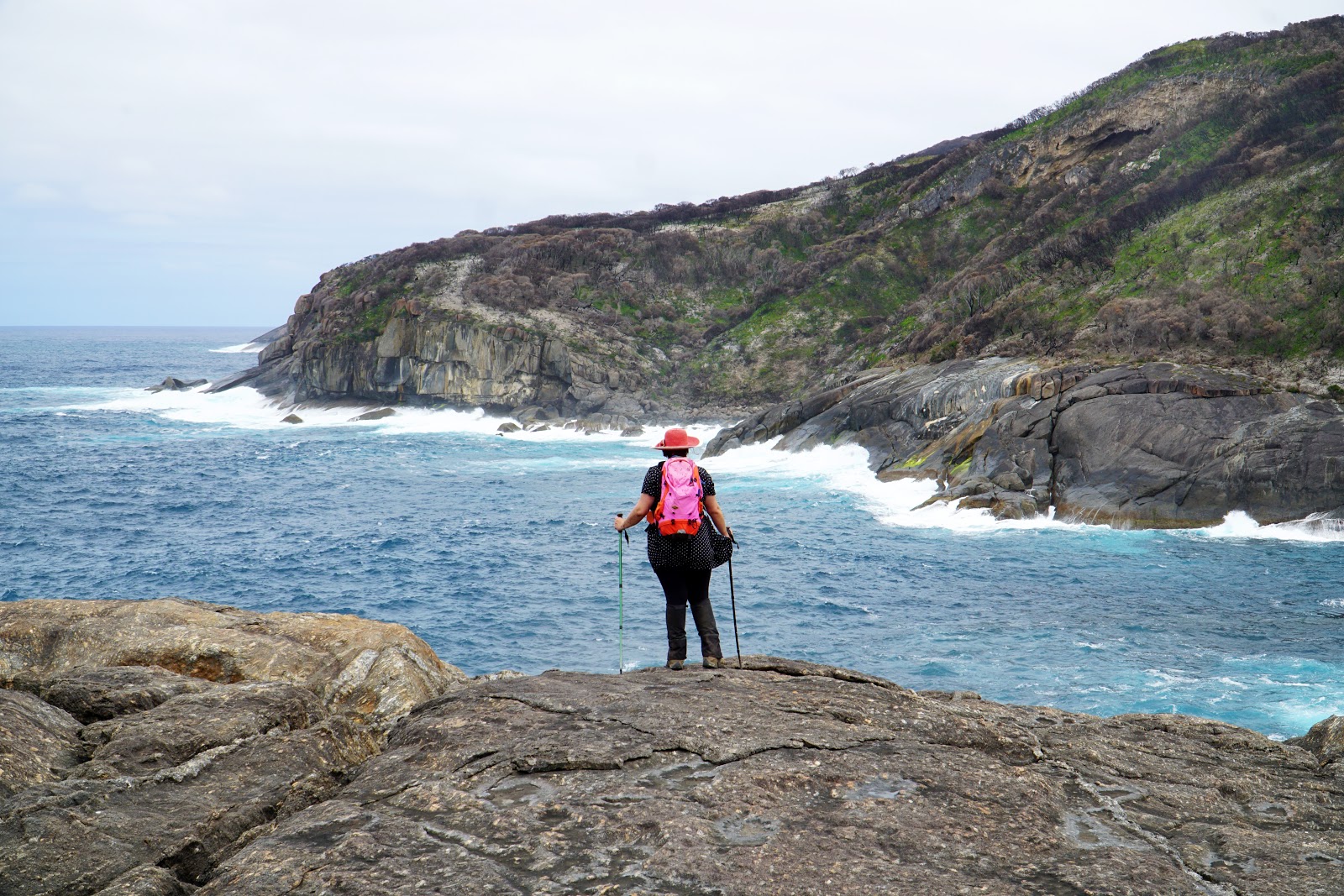
In spite of the damage that has been done to this track, the sheer beauty of the view from the granite headlands really made this walk. Having explored the similarly under-developed West Cape Howe National Park a few weeks earlier, I couldn't help but think about how the spectacular coastline of the South Coast could have been the home to a truly great walking track along the lines of the Three Capes Track as there is just so much potential in this area.

Alissa and I took the opportunity to stop and take in the dangerous beauty of the coastal conditions, with massive waves crashing into the rocky coastline.

The force that the waves were hitting the rocks was intense, and there is a sobering reminder of how deadly these waves can be - along the rocky shelf is a plaque dedicated to Rowan Cook, who disappeared from the area in 2013 and is suspected to have been taken by the sea.
You can definitely see that there would be no surviving once you fell into that water, but from the relative nsafety of the granite headlands, the show the waves put in is quite amazing.

From the vantage point overlooking the rocks, I decided to continue onwards a bit further to get a better view of Aldridge Cove itself.

The waves crashing into Aldridge Cove were insane; massive walls of water repeatedly slammed into the rock, while the cove itself looked to be sheltered and safe by comparison. In the distance, Alissa and I noticed a cave high along the the cliffs on the other side of the bay. The plaque dedicated to Rowan Cook seems to suggest that he had been perhaps trying to get to the cave when he slipped and fell into the ocean below. While I've read of people going to visit the cave, the real danger of death should be a warning to not underestimate the forces of nature and make risky decisions in this sort of place.

After enjoying the views for a while, Alissa and I made our way back along the Nuyts Wilderness Track and to our car near the Deep River.

While currently scarred by senselessly over the top prescribed burns, the Nuyts Wilderness Track features a stunning variety of scenery, ranging from the cool forests near the start of the track, the savannah-like grass plains of the middle section and the spectacularly rugged coastline towards the end. Aldridge Cove in particular is worth the effort alone, and it should be more regularly visited than it currently is.
Given that this area is not a true wilderness, I feel like there is so much opportunity for improvement through this area, and it had me brainstorming ideas for how this area could be made into a great loop walk. My thinking was that walkers could start where the car park for the Nuyts Wilderness Track starts, head towards Long Point for their first day, then follow an alternate coastal track to Aldridge Cove and up along the Nuyts Wilderness Track before descending to the campsite at Thompson Cove for the second day. Then for there the track could go up and over Mt Hopkins and descend back down and make its way back to Deep River. That would be an enjoyable three day loop, and with Western Australia greatly lacking in shorter multi-day walks, this longer Nuyts Wilderness Circuit would be a fantastic way to take in this great section of the coast. For now, the Nuyts Wilderness Track does at least exist, and I hope this post gives it a bit more attention than it currently gets.


0 comments:
Post a Comment