

The first part of a planned multi-day loop in Wellington National Park, the Wiilman Bilya Trail follows the shores of Wellington Reservoir from Coalfields Hwy to Wellington Dam itself. Passing through some of the finest Jarrah forest in Australia to the excellent Nyingarn campsite, the trail is left down by some compromised route choices and severe burns through extended sections that spoil the trail's natural beauty and potential
Distance: 20 km (one way)
Gradient: Mix of relatively flat and moderately undulating walking
Quality of Path: Relatively clear and generally well maintained, except in some of the burnt sections where it is indistinct. A mix of purpose built single file walk trail and vehicle tracks
Quality of Signage: Excellent directional signage for most of the walk, with very informative trailheads at both ends
Experience Required: Some Bushwalking experience required given the indistinct trail through some burnt sections
Time: 5-6 Hours
Steps: Some formal steps near the campsite and across a pipeline, with some mildly eroded tracks with informal steps
Best Time to Visit: Autumn-Spring
Entry Fee: No
Entry Fee: No
Getting There: The trail starts on the car park on Coalfields Hwy or the kiosk near Wellington Dam. If heading towards Collie on Coalfields Hwy, turn right off Coalfields Hwy 7 kilometres after the turn off to Wellington Dam Rd. The car park and trailhead are located at the end of the unsealed road. The kiosk car park is located at the end of Wellington Dam Rd

In late January 2019, the Western Australian trails community was delighted by the announcement of the completion of the Wiilman Bilya Trail - a 20 kilometre walk built in Wellington National Park, and the first major trail of a decent length built within a short drive of Perth in over a decade - possibly more. Heralded in media statements by the Department of Biodiversity, Conservation and Attractions as a 'world-class' walk (albeit with no clear quantification of the term), the trail was quickly added as a priority for the 2019 hiking season. Being a one way walk requiring a car shuffle, Mark (of Life of Py fame, and my co-host of Real Trail Talk) and I decided to team up to do the walk together in mid-June, coincidentally scheduled for the same days as a heavy downpour was forecast.

While we had some heavy rain on our way down to Collie, the rain had died down by the time we found the poorly marked car park for the Wiilman Bilya's northern trailhead. For a much-heralded new trail, the signage for the start of the walk is somewhat lacking, and even when you arrive at the trailhead there is no clear indication of how you should get to the actual start of the walk on the other side. We would figure out that the best way to get there is to follow the road and pick up the trail on the other side of the creek, however with no signs to indicate the way to go we ended up walking across the dry river bed and passed a large storm drain.

While June 2019 had been the wettest June in 14 years, the very dry Summer and Autumn meant the water was not flowing through the drain at the time of our visit, allowing us the opportunity to peer inside as we made our way across to the start of the walk.

Successfully on the other side and doubling back slightly to actually get to the start along Coalfields Highway, Mark and I found ourselves immediately and pleasantly surprised - the forest was beautifully dense and lush. Long time readers of the blog and/or listeners of Real Trail Talk will know that I often find the Jarrah forest ugly as it is often scrappy, burnt and blackened (just Google 'jarrah forest ugly' and see what comes up one the first page), but was this some of the nicest and most beautiful Jarrah forest I've had the pleasure of walk through - and were were only a hundred metres from the road!

The understory was alive with moss growing along the logs on the forest floor, giving the area the kind of interesting detail I more often associate with the lushness of the Karri forest further south. Even the wet Jarrah forests near Dwellingup are not quite as lush as this.

The initial stretch of walk trail joins onto a vehicle track, with clear directional markers pointing the way. The markers used are a fairly generic foot symbol used on many DBCA trails, and while not an important detail it would have been nice if the trail had its own symbol given that the eventual plan is for the Wiilman Bilya to be part of a four day circuit walk to and from Collie. Just take a look at how successful the Bibbulmun Track has been with its Waugal as an example of how an iconic symbol can really help with a trail's promotion.

During this stretch, the trail provides a nice mix of scenery. While the dense forest predominates on the western side of the track, the eastern side varies from dense forest to open sections that provide views of the dam. At the time of the year we visited, this part of the dam had yet to fill up, and we could see where bogans had driven their four wheel drives through the area. Looking across the other side of the river, we could see a burnt out car - one of the characteristic sights while hiking in the Collie area!

The burnt out car was only a minor unsightly moment as the forest along the track was uniformly excellent. Mark and I were really enjoying ourselves, and we were beginning to agree that the 'world-class' moniker was not just hyperbole.

Given the serious issue DBCA has with four wheel drives and dirt bikes ignoring 'no entry' signs and driving to campsites, the trail makers did a great job making the trail inaccessible to vehicular access. Instead of the lighter gates that can be easily pulled out by a 4WD or ute with a winch and enough torque, a really serious gate has been installed along the trail that would be difficult to get around and to pull out. It is sad that we have to go so far to deter people from doing the wrong thing, but given it is necessary it is good to see the department being proactive about it.

Not long after the gate, the Wiilman Bilya departs the vehicle track as it turns right onto purpose built single file walk track.

With the trail heading deeper into the forest, the quality of the walking only increased. I had to admit that I was seeing a different side to the Jarrah forest that was streets ahead of the usual burnt Jarrah of the Perth Hills that I find so repugnant.

3.5 kilometres into the day's kilometres, Mark and I were delighted to see a sign indicating that the Nyingarn Campsite was just around the corner.

First off, we passed the rather impressive toilet block, which was even more deluxe than the recent rammed earth toilets built at the rebuilt Bibbulmun Track campsites.

The Nyingarn Shelter was in a similar style to those seen at the group campsites on the Bibbulmun Track at Mt Cooke, Lyall's Mill and Arcadia but with two complete walls.

The campsite is exceptionally well located; steps from the shelter area lead down to the water's edge and provide stunning views of the dam and swimming access. While it may seem a bit far-fetched to compare the Wiilman Bilya to the Overland Track in Tasmania, there was something about the campsite's location by the dam and the surrounding forest on the shoreline that reminded me of Echo Point along the shore of Lake St Clair. Which is to say I thought this was a really great campsite location, and one I'd happily return to to stay the night.

While the shelter would be a good place to pitch a tent in a torrential downpour, I think the tent sites have the edge on the shelter as a place to camp for the night. The well constructed stairs lead to tent sites that have been thoughtfully dispersed through the forest, with natural features like logs being used as edging along the trails. This is a great campsite, and certainly gels with the trail's ambitions for world class quality.

After spending some time enjoying the campsite and its spectacular location, Mark and I continued along the Wiilman Bilya. Having only walked 3.5 kilometres, we still had a lot more kilometres to cover and were looking forward to see what the rest of the trail looked like.

A break in the trees provided us with another great view of the dam and the forest beyond. What we didn't know at the time was that the forest views were heralding something of a change in scenery less than half an hour into the future...

But for now were were continuing to appreciate the almost karri-like lushness of the forest and the massive, moss-covered logs along the trail. Mark even said to me 'you know, I can't fault anything about this trail so far', and I wholeheartedly agreed.

And then this happened. Crossing a vehicle track, the lush greens and dense understory were replaced by something I'd dreaded but thought to be impossible for a supposedly 'world-class' trail - forest that had been made hideously blackened and burnt by a very recent prescribed burn. Mark and I laughed at the stark contrast and transition to one of my most hated landscapes to walk through, and we hoped it would be a cool burn in a minor mosaic pattern that maybe only lasted one or two kilometres of the walk.

It wasn't, and it didn't. All up, the burnt section lasted in excess of five kilometres, meaning a quarter of the Wiilman Bilya Trail is disgustingly ugly and terribly austere walking. Having been lulled into a false sense of excellence by everything we had seen for the first quarter, this really cut like a knife and brought our ebullient mood back down to earth.

At several times along the five kilometres, Mark and I encountered sections where the trail had been severely damaged by the fire, with burnt out roots creating holes along the walk and widow makers having fallen across the track. On top of this, the open forest floor rendered the trail difficult to discern in parts, and I would recommend only experienced hikers who are paying close attention to their surroundings should attempt this section.

While safety was obviously a concern, we were particularly angered and frustrated by the fact that the Wiilman Bilya Trail had only just opened in early January and had been touted as world class quality, but here we were five months later walking through forest that was hideously disfigured before its first hiking season. While neither Mark or I completely oppose prescribed burning, there appears to be an utterly thoughtless attitude to the economic value of presenting pristine forest for walkers to enjoy, as if walkers will not care about the quality of the scenery along the trail they are walking.

There is a really frustrating attitude in Western Australia that seems to be based on a belief that if a great campsite is supplied then it is immediately world class even if it fails the world class test on all other measures. While the Bibbulmun Track huts are indeed praiseworthy, I'm sorry but I think for a majority of hikers scenery along the trail is an important part of why they do what they do, and while some great trails do have great campsites, a great campsite only makes a great campsite, not a great walk. As long as the actual walking experience is treated with a utilitarian attitude rather than a more nuanced approach to prescribed burning, I think it is laughable to consider this world class.

Passing by large, blackened logs along the trail, I couldn't help but think how beautiful and similar to the first 3.5 kilometres this area must have been before the fires, especially when we could seem so less burnt logs that showed a green tinge of moss still holding on in this scarred landscape.

Every now and then Mark would think we were about to end the dull burnt Jarrah walking, only to be disappointed to see it continue. Remnant sections here and there showed how beautiful the forest was, and confirmed to Mark and I that it would have been of a similar density and beauty to the first 3.5 kilometres of the walk.


Breaks in the forest that allowed us to wander to the banks of the dam were a wonderful respite from the oppressiveness of the blackened visage and acrid stench of the despair-inducing forest we'd been engulfed in, and we took to looking ahead to see just how far the burns went. Sadly, the answer was often not very reassuring.

Considering how severe the burns were, Mark and I were amazed to see bridges along the trail in perfect condition. We wondered how on earth these things survived and whether or not bridges are removed during a burn, or if some kind of anti-fire treatment is used.

The walking actually got worse further into the forest; while early on Mark commented on the fact the crowns of the trees were intact, we soon entered a particularly bad section where the blackening had been far more intense and all-encompassing.

This was most definitely not a cool burn; this was a hot burn that seemed out of control. I think it is telling that DBCA refer to it as prescribed burns and not controlled burns, as they seem to lose control of them with alarming frequency.

Passing over a log, Mark and I laughed at the sight of recently made trail infrastructure having been indeed destroyed by the burns. A log that had been carved with a step on it had burnt out and had twisted so that the step was now on a severe angle rather than right on top. Nice work for a trail less than six months old!

Another break in the forest with a wide open section of shoreline along the dam provided us with a lunch stop. Mark hadn't said anything at the time, but the sheer oppressiveness of the forest had really gotten to him, and he needed a break from it for a moment.

After lunch we begrudgingly continued on our way, and we were delighted to encounter fairly normal Jarrah forest that, while clearly showing signs of burns in the recent past, was at least not 360° views of freshly charred blackness everywhere you looked.

The forest improved so much that Mark was able to resume finding 'the devil in the detail' that is a trademark of his blog photography.

It was nice to see a section of the track over Dolerite and Granite that was covered in a healthy level of moss. Hiking with Mark, I was even more careful than usual not to stand on the moss out of fear of incurring his wrath given this is one of his pet peeves.

After ascending slightly, the trail continued through some burnt but nevertheless acceptable Jarrah forest walking.

The appearance of a water pipeline with a series of steps crossing it marked the beginning of the transition to the next thematic section of the track which I refer to as the 'farm fence' section.

Walking over the pipeline, Mark and I had to laugh at what we encountered - a sign indicating that the trail had been closed, meaning all that burnt forest we had walked through had probably not been cleared for safety after the fire. This explains the widow makers and indistinct trail, however it calls into question why a similar sign had not been placed at the other side. Had Mark or I been injured, I'm pretty sure DBCA would be liable and that should be a real concern to them and reason enough to review their safety practices. It is almost as if those doing the prescribed burns had not really put much thought into the fact that the trail can be walked in either direction, and we did not see any 'Track Closed' information at either trailhead. Safey aside, it is also fails to consider people heading out for a weekend adventure in the park. Imagine if you'd planned to camp overnight at Nyingarn Campsite and had walked from Wellington Dam - you would have walked 10 kilometres only to find the track closed and have to double back without being able to make it to the campsite!

Beyond the pipeline, the trail follows the fence of a private property for 3 kilometres. While the scenery was still a vast improvement on the horror of the burnt section, this was not ideal either, as the unimaginative and expedient route along a vehicle track did not scream 'world class' to Mark or I. Perhaps we may have been more forgiving if not for the burnt forest, but we both agreed some single file walk trail could have been cut through the forest so as to give the illusion of wilderness rather than the very obvious compromise that this section lays bare.

Walking along the fence, Mark and I completely lost sense of time and space as we were made to take an inordinate amount of left turns around the property, to the point where we could no longer tell where north was supposed to be. To add to the disorientation, the promised rain began to fall along this stretch, leading to Mark putting on his camouflage raincoat with his camera tucked inside to keep it safe from the rain.


With rain varying in intensity as we continued following the fence's left turns, Mark and I encountered some of the steepest sections of the Wiilman Bilya. Some of these steep, eroded sections of vehicle track were smooth and lacking in grip, and Mark and I had to take our time to carefully make our way down without slipping.

A highlight of the farm fence section was the appearance of brilliant coloured flowers growing just off the track. While Mark and I were fairly sure they weren't natives, we nevertheless appreciated the burst of colour after the black, grey, army green and khaki colour scheme that had dominated most of the day.

Turning right to follow the pipeline, Mark and I were grateful to be leaving the farm fences behind.

Or so we thought; after turning left onto another vehicle track, Mark and I found ourselves once again following the fence around the private property.

Some of the open fields here did provide some interesting scenery, with some farm animals watching us as we walked past. The waters of the dam are also visible in the background, providing another source of interest beyond ceaseless fence line.

Finally being rid of the farm fence section, the Wiilman Bilya continues to follow vehicle tracks through the Jarrah forest. the forest here was quite nice, however it still was not quite on the same level of excellence as what we had encountered near the start of the walk.

Having been bored by the monotony of the burnt forest and the fence line walking, Mark and I were ready for anything exciting and out of the ordinary, and an eroded section of track flowing with rain run off was exactly what the doctor ordered. This should give you and indication of how low we'd gone that eroded track was a trail highlight!

While we were clearly disappointed with many aspects of the trail, a short section on single file walk track served as a great example of something we felt the trail makers should be praised for.

In spite of having being opened in Summer, the trail designers had obvious put some thought into the fact that the vehicle track gets very flooded and the diversion on walk track took us around what would have been a difficult puddle to completely walk around. Seeing the puddle made me think of Alissa, as if she had been here she might have been able to (intentionally or unintentionally) recreate her famous puddle fall between Dookanelly and Harvey-Quindanning Rd on the Bibbulmun Track.

After passing through a section that was dominated by soap bush encouraged by a recent prescribed burn, walking conditions improved immensely as we entered a section under purpose built walk trail that is distinctive due to the unusually high number of large grass trees growing through the area.
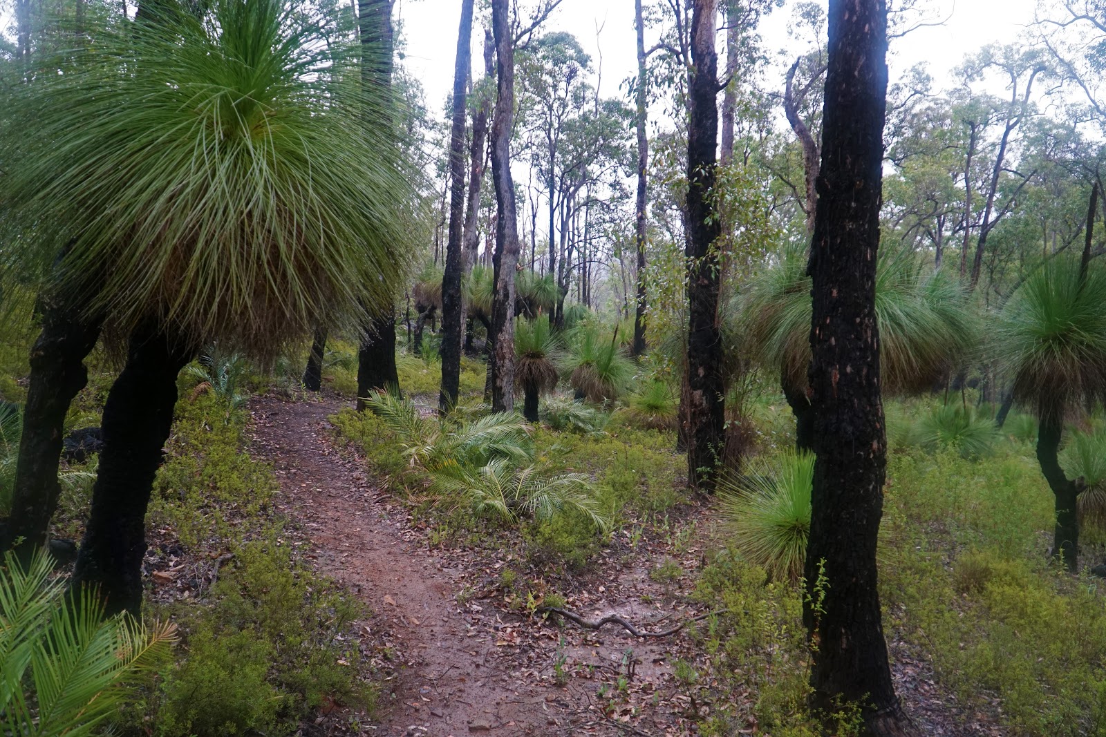
While not burnt to a cinder like the section between Nyingarn Campsite and the farm fence, the area's relatively recent prescribed burn meant the area did not have the dense understory that we'd experienced earlier on the trail. Fire causes most grass tree species to flower profusely, so prescribed burns in this section of the track are perhaps a bit more understandable, however I hope that DBCA are careful during future burns as it would be a shame to have some of these tall and impressive grass trees destroyed given this is a fairly unique stand.

Crossing a massive fallen tree via the steps cut into it, I was taken by a particularly large mushroom growing along it. I've always been fascinated by the mushrooms of the Australian bush, particularly because some of them are perfectly edible while others are extremely poisonous; the fact we don't really know very much about the culinary value of our wild mushrooms is something I hope will improve as there must be a fair amount of untapped potential here.

With all the rain we'd had since the fence line section, it was not surprising to finally see one of the creeks flowing. There had been so many of these bridges along the walk with dry creeks, and it was nice to finally see one actually being useful rather than just ornamental.

Rising to cross Tom Jones Drive, the Wiilman Bilya joins onto the dual use Sika Trail.

Mark had walked this trail a year and a half ago, and what greeted us was a really disappoint for Mark. Since his December 2017 visit and June 2019, the area had been prescribed a burn of its own. While it was not quite as terrible as the seriously burnt section of the Wiilman Bilya, the result is in sharp contrast to the very pretty Jarrah forest scenery Mark was gifted with when he did the Sika Trail. Having already been down for so much of the walk, I was basically broken by it now; I just wanted to get it over and done with as soon as possible and go home.

A side trip from the trail leads to Potters Gorge campsite at the somewhat cryptic marker seen above. While the signage is understandable, it would have been nice if the sign actually said why the arrows point in both directions rather than just hoping people can follow the slightly confusing arrangement. Having both visit Potters Gorge a few years ago, Mark and I didn't bother with the turn off and instead kept pushing on to the end of the trail and a hoped for a meal and a drink at the kiosk (which, other than a single pie for me, sadly didn't really eventuate).

Ascending away from the Potters Gorge turn off, the trail passes by a bit of Bibbulmun Track history. While it is not obvious today, the Sika Trail (or Sika Circuit as it was known) was once part of the 1988 Bibbulmun Track and was blazed with red coloured waugals to indicate it was a loop off the main track. While the 1998 Bibbulmun Track was an improvement in almost every way, the loop walks off the Bibb idea was the baby thrown out with the bathwater, and it is something that the Bibbulmun Track Foundation are hoping to bring back sometime in the near future.

Along the home stretch to the dam car park, a large granite boulder served as the last major feature of the trail in otherwise blackened forest. There was a stretch that Mark was able to recognise as being where he took one of the feature photos for his Sika Trail post and it looked unrecognisably burnt in comparison.


Crossing Wellington Dam Rd, the Mark and I reached the end of the Wiilman Bilya Trail, relieved to be finished and ready for the long drive home.
What to make of the Wiilman Bilya Trail? I think it is fairly obvious that the trail was something of a mixed bag. The section immediately adjacent to Coalfields Highway all the way to the Nyingarn Campsite and a bit beyond is spectacular and befitting of the 'world-class' definition that was bestowed upon this trail, with Nyingarn itself being a great campsite I would happily return to again. It made me, a noted critic of the Jarrah forest, a believer that it could be every bit as a beautiful as the more instantly likeable Karri forest.
As good as this start was, it is the horrendously burnt forest that unfortunately spoiled the experience and left a lasting impression on me as it seemed so utterly unnecessary and completely thoughtless in its execution. While I understand that prescribed burns can be a necessary evil and is done for well meaning reasons, the attitude of expedience being the most important driver of decisions and a lack of consideration for the tourism aspect really needs to be called out, as DBCA's prescribed burns unit seem utterly oblivious to what effect it has on the overall hiking experience and don't take this into account when making their plans. And to do it before the Wiilman Bilya Trail could even have its first springtime hiking season is a slap in the face of all the people who made this trail possible and continue to passionately advocate for trails in the Collie area - which ironically includes people from DBCA itself!
It is completely laughable and insulting to the intelligence of experienced hikers and international/interstate visitors to call a trail 'world-class' and then destroy the scenic value of an area by burning the shit out of it, and it makes me very worried that the first five kilometres of the walk and the area around the campsite will be earmarked for a burn in the near future for a complete trailhead to trailhead exercise in ugliness. It fills me with despair for the future of trails in this great state to think that it may well be impossible to ever walk this whole trail in pristine quality at any stage in the future. I'm sorry to say but if it can never be good from start to finish because it is always at least partly burnt, then you simply can't sell it as a world class experience.
Are there not other alternatives to such a heavy-handed burns regime? Is it not possible to burn but leave a corridor along the trail so hikers can enjoy lush forest, much like how native forest is grown as a screen to sanitise the orderly rows of pine plantations? Could some kind of sprinkler line be used as a containment strategy as was recently used during fires in Tasmania, especially given the convenient location of a dam right there in the park? The government may be commendably pouring $10 million into new trails in the area, but for all but the most ascetic of hikers I don't really see the point if the scenery has little to recommend it. I'd rather see less money spent on trail construction if it meant DBCA being able to do prescribed burns in a more nuanced fashion that genuinely took hikers and the trail experience into account.
The frustrating thing about this whole situation is that the first five kilometres from the highway suggested to me it is not just an economically sensible plan to fund walk trails in Collie to help it transition away from its inevitable demise as a coal town, but that the Jarrah forest of the area is also entirely worthy of being given a great trail. While writing the first part of this review on a plane, the passenger beside me commented on how beautiful the forest looked during the stretch to the campsite, even asking me if it was somewhere in New Zealand! Just imagine how great this walk would have been if the entire trail was of a similar quality from start to finish! With some minor realignments during the farm fence section and if the forests along the track were allowed to be left alone and recover for the next 10-15 years, I think the Wiilman Bilya Trail does have the potential to be the 'world-class' walk it was claimed to be. For now though and while the current burns regime remains in place, I would thoroughly recommend the camping experience of heading out to the excellent Nyingarn campsite, but this is most definitely not a world class walk.
And that is a real shame as it so easily could be.


0 comments:
Post a Comment