

The third and fourth day of the Frenchmans Cap Track, these days are usually reserved for the return journey to Lyell Hwy. Exploring the same terrain seen on days 1 and 2, the changeable weather provides for an opportunity to experience a different side to Barron Pass, the rainforests and Loddon Plains. With an overnight at Lake Vera, this is a great way to end one of Tasmania's best walks
Distance: 19 km (4.5 km for first day + 14.5 km on second day)
Gradient: Undulating from Lake Tahune to Barron Pass, followed by a steep descent to Lake Vera. Relatively gentle walking to Lyell Hwy, with a moderately steep ascent and descent over Mt Mullens
Quality of Path: Very clear and well maintained. A lot of work has gone into hardening some of the swampy sections, and the result is a mostly dry track with some muddy sections
Quality of Signage: Largely well signed, with a clear and informative trailhead and some markers along the way
Experience Required: Previous Bushwalking Experience Required; this is not an easy walk and it is best that potential walkers gain experience on easier trails in Tasmania before tackling the Frenchmans Cap Track
Time: 4-5 Hours each day
Steps: Many steps, both formal and informal
Best Time to Visit: Summer
Entry Fee: Yes. National Park Fees apply
Getting There: No direct access to the start of this section. Access is via Lyell Hwy (A10). From Hobart, follow the A10 through Derwent Bridge. The car park is a further 29.1 kilometres west along the highwayEntry Fee: Yes. National Park Fees apply

What a difference a day makes. After a day of outstandingly clear views basically all the way from Barron Pass to the summit of Frenchmans Cap, Alissa and I woke up after a night of broken sleep in Lake Tahune Hut to cloudy, rainy weather. With the weather forecast for the day supposedly better than the previous day, it was quite a shock to see the weather take such a turn for the worse, however it was very much in keeping with my expectations for the unpredictability of mountain weather.

Given that an ascent to the summit would be cloudy at best and dangerously slippery at worst, Alissa and I were really glad that we had summited when we did, and felt sorry for the scout group who had decided to climb to the summit on this day given the forecast for better weather. The downside of the sudden change in weather is that I was not able to get some of the photos I'd run out of time to take the previous day, such as the outstanding views from the helipad at the front of the hut, and the view from the toilet. Featuring a window overlooking the Artichoke Valley and with the mountains of the Overland visible on the horizon, this has to be the best toilet view in Australia!

Although we debated pushing all the way to Lyell Hwy, Alissa and I decided a relatively easy day descending to Lake Vera would be much more enjoyable after our fairly tiring day yesterday. With plenty of time to get to Lake Vera, we had a slightly lazy morning before heading off along the track in white out conditions.

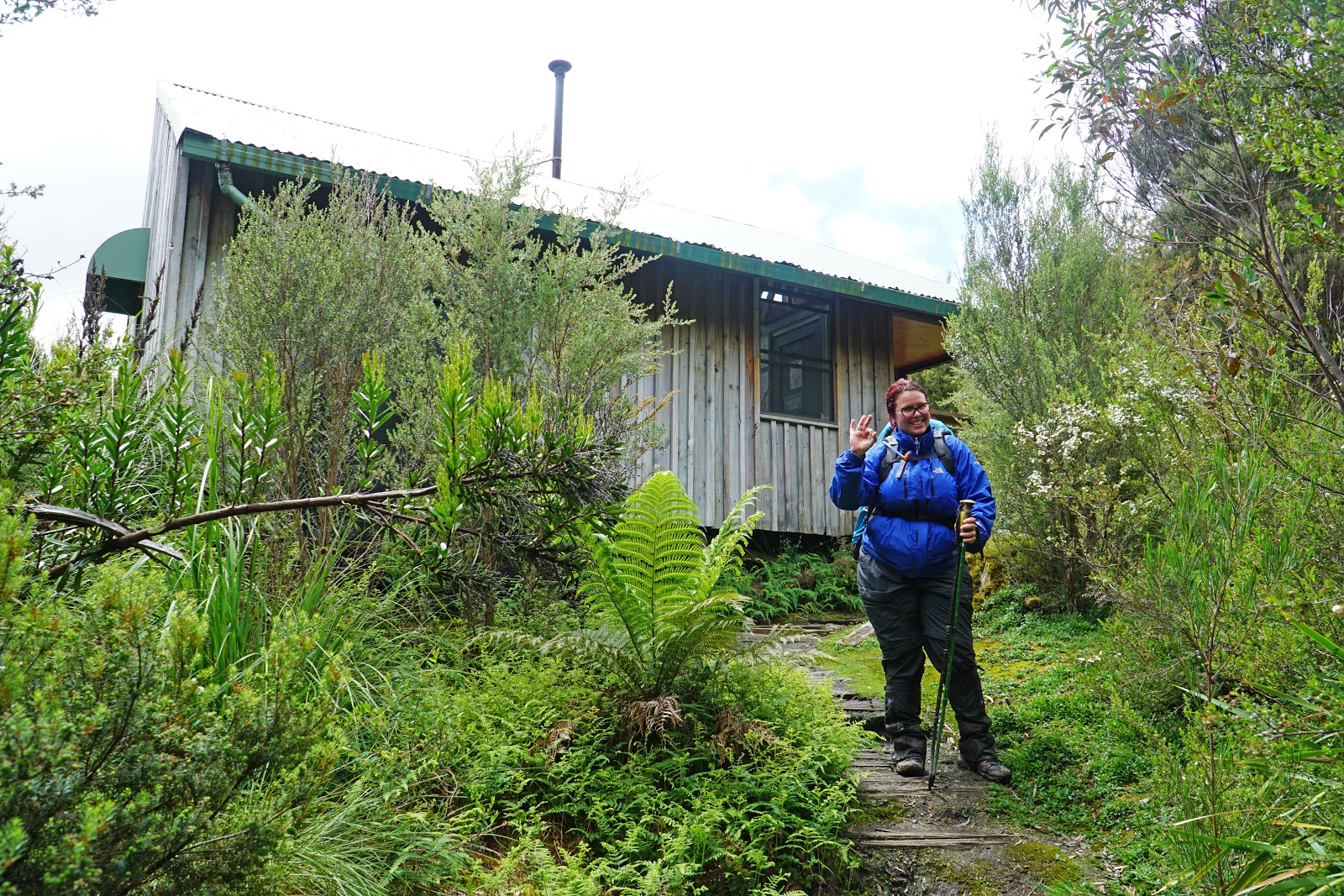
Having rushed ahead of Alissa to get to the hut the previous day, we had been separated by about 10 minutes and I hadn't been with her when she fell down the flight of stairs pictured above. Alissa took it in good spirits at the time, with her soft pack saving her from a injury as she slid backwards and down the stairs before stopping herself near the bottom. With no other people near us, plenty of time to get to our destination and with white out conditions, we agreed that we would stay together all the way to Lake Vera for safety's sake.

This section near the hut also passes through a stretch of track lined with waratahs, and with a more leisurely pace I was able to snap a few photos of these beautiful flowers in bloom.

After overcoming the slight ascent away from the hut, the track levels out as is passes the area that looks like a manicured alpine garden. On the previous day, Alissa and I had outstanding views of Frenchmans Cap towering ahead in the background, but now we could barely see more than 20 metres ahead of us.

While views are preferable to white out conditions when climbing a mountain, the fact we were passing through the same area again meant it didn't much matter what we were missing out on. If anything the low visibility gave the area a dramatic moodiness that made the day's walking feel like were doing a completely different walk even though this was a there and back return track. This is one of the reasons why Frenchmans works so well in spite of the fact one way or circuit hikes are usually preferable; the changeable weather means you get a higher chance of seeing the same trail in a different light.

After descending the stairs, Alissa and I had to scramble up the rocky and unsheltered section of the ridge. It has been an easy downward scramble the previous day, but with rain, freezing cold winds and an uphill climb, it was a lot more difficult on the return. Thankfully the unsheltered nature of this section didn't last long as we descended from the top of the ridge with the mountains providing a windbreak to the north-east.

As we continued along the track, we could see the clouds beginning the part. Below us we could make out Lake Gertrude and the densely vegetated valley below.

While still largely enshrouded in cloud, Sharlands Peak was becoming increasingly clear, and we were surprised by our relatively good progress.

As we got closer, we could even make out Barron Pass, though White Needle still appeared to be largely obscured.


After passing through the boulder field, Alissa and I dipped down once again into the small pocket of rainforest before ascending steeply to Barron Pass.

By the time we arrived at Barron Pass, the visibility had improved greatly, and we were able to make out both White Needle and Nicoles Needle. Views back across the ridge towards Frenchmans were still pretty poor, and we hoped that the scout group would have at least some views from the summit.


After a quick snack break at Barron Pass, Alissa and I began the long, steep descent to Lake Vera. Unsurprisingly, the descent was far easier than the ascent, however the combination of wet, slippery log ladders and the typically tangled roots of the rainforest meant it was still fairly slow going relative to the high speeds you can almost run down clearer terrain. Along the descent we ran into a number of groups heading up to the summit, and while Lake Tahune hut was far from at capacity, we were glad we stayed at Lake Tahune with only six people (ourselves included).

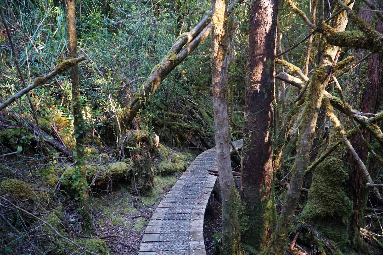
Entering sections of boardwalk was a welcome relief, however we were careful not to move too fast on any that didn't have the extra grip of chook wire for safety. Alissa and I have found that it is these seemingly easy sections that are the most likely places for injury, with Alissa having fallen through the boards of a slippery bridge on the Bibbulmun Track, and I have sprained my wrist embarrassingly on a Class 2 walk along the Luke Pen Walk in Western Australia.

The upside of all the rain is that the waterfalls and cascades along Vera Creek were even more spectacular on the way down.

Alissa and I loved this return section along Vera Creek, as it meant we could enjoy the beautiful sights without the strenuous uphill walking we had experienced the first day. It also meant we sometimes stopped and appreciated areas we had missed in our haste, such as this beautiful waterfall just to the right of the track.

Once we reached a section of increasingly steep descending, Alissa and I knew we were getting close to the start of the walk along Lake Vera.

Crossing Vera Creek, Alissa and I were now on the mildly undulating home stretch to Lake Vera Hut!

Along the track, I spotted a side trail I had missed the previous day, and decided to head down it to explore where it might lead. To my delight, the track led to an excellent view of Lake Vera. By this stage the clouds had really parted and we were able to see the mountains that surround this beautiful lake.
After 4.5 hours of descending, Alissa and I were pretty pleased to be back at Lake Vera hut once again. The most challenging walking of Frenchmans Cap was behind us now, with only the relatively easy track from Lake Vera to Lyell Hwy left for us to do the next day.

While the hut bottleneck was not as bad as it had been the previous day, Alissa and I agreed that we have come to prefer the comfort of sleeping in a tent. I had found the moonlight coming in from the window at Lake Tahune had kept me up the previous night, as well as the fact I forgot to put my liner around my Sea to Summit mattress to reduce the noise. I ended up waking up in the middle of the night to fix it to prevent the crinkly sound it makes when turning. Alissa interesting found the spaciousness of the bunk her main problem, as she found that the walls of the tent help keep her from sliding off her mattress and make her feel more secure.
Lake Vera tent platforms - Spherical Image - RICOH THETAOur tent had been wet from two days prior, and thus our main priority was setting it up and letting it air out and dry. Considering the freezing cold winds of earlier in the day, the weather took a complete 360° change to searing hot sunshine but the afternoon, and our tent and wet clothes were dry within less than an hour! With such lovely tent sites beating the crowded hut, Alissa and I agreed this is the best way for people to experience their time at Lake Vera until they potentially expand the current hut or build a second one for those descending.

With plenty of time, Alissa and I spent the rest of the afternoon relaxing and socialising with the other hikers at the hut. As with our previous stay, we found that the hikers were overwhelmingly Tasmanians, with quite a number of them being experienced hikers who were here to check out the new hut while on Christmas break. It was interesting picking the brains of the experienced hikers for future Tassie visits, as well as in turn providing advice to less experienced hikers. A particularly fit but inexperienced hiker had come in with Lyell Hwy and was pretty shattered, but had set himself the goal of pushing onto the Lake Tahune. Having carried way too much gear and water with him (you don't need to be carrying four litres of spare water in Tasmania), we advised him about what he could afford to leave at the hut to lighten his load. He was interesting guy with so much knowledge about restaurants and cafes we were convinced he must be a restauranteur or experienced in the hospitality industry, however he admitted with a slightly sheepishly grin it was not so much experience in the industry as experience in appreciating the hospitality industry!

Having had cloudy skies on our first night at Lake Vera, it was nice to actually be able to see how beautiful the area is. While it does not have the reputation of Lake Tahune, this is still a really lovely area that is just as nice as many of the campsites on the Overland Track.

Given that we had spent quite a lot of time with the scout group, we ended up chatting with them the most once they had made it down from the mountain. Their experience of the summit was far different to ours, with low visibility even though they had waited for some time for the weather to clear. With clearer, almost cloudless skies in the afternoon, they had been really unfortunate as those heading uphill to summit in the afternoon would have probably had even clearer views than I did!
The scout who had decided to stay an extra night at Lake Vera rather than pushing onto the summit had brought a can of Spam with him, and had become quite obsessed with it and Spam's reputation as a widely disliked food product. He began almost exclusively talking about Spam for several hours, and he amused us with a slew of puns and comically strange ideas for a restaurant that only serves Spam. He pushed the joke almost a bit too far, and I said to Alissa that it becaome almost like a conceptual art piece where he was almost literally spamming us with information about Spam!

After dinner and one of the best night's sleep I've had on a trail, Alissa and I woke up to the sight of sunrise over the mountains. Alissa joked that it looked like a Mac OS background, a fairly apt reference considering the slew of mountain images that are ubiquitous with an Apple computer.

After a fairly quick pack up of our gear, Alissa and I were on our way back to Lyell Hwy in the golden glow of the morning light. We were hoping to get to the end as soon as we could, as lunch at Derwent Bridge and a check-in in Queenstown awaited.

The walking conditions were very different from the first day of our walk. While the track was a clear improvement on the muddy walking of the Sodden Loddons, it was still muddy and wet in places. Due to the heat of the previous afternoon and the morning, the mud had baked firm and dry, and we were able to make it all the way to the car with dry feet for what must be the first time on a trail in Tasmania!

The walking along Laughtons Lead was even easier in this direction as it trended downhill, and I compared it to the Bibbulmun in terms of being able to almost set it and forget it the whole way. This was the least 'active' walking Alissa and I have done on a multi-day walk in Tassie as we were able to power through without having to really think about where we were placing our feet.

Leaving Laughtons Lead and entering the Loddon Plains, it was nice to be able to see Frenchmans Cap in the distance, especially since such views were completely shrouded by clouds on the first day.

After stopping for a quick break just before the Loddon River, Alissa and I crossed the suspension bridge as we began our final major climb of the Frenchmans Cap track.

From the Loddon River, the track starts heading up towards Mt Mullens, with an almost continuous stretch heading up steps. While the heat of the day had made for dry boot walking, it almost made the ascent all the more difficult due to the heat and high UV. Alissa and I were glad to have our big, super dorky wide brim hats with their legionnaires-style party in the back as it gave us some shade in the open section.
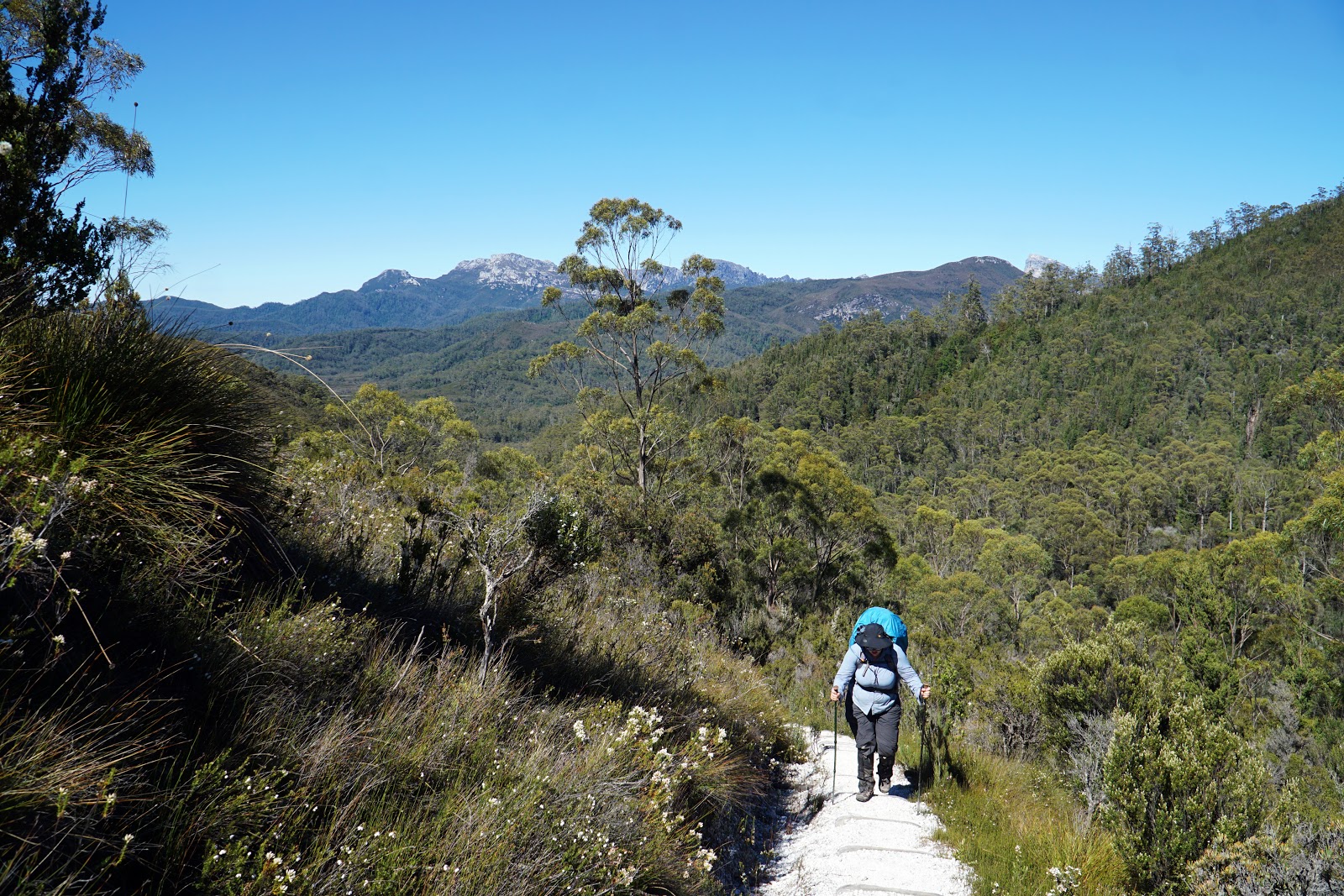

Reaching the high point of the track near the top of Mt Mullens, Alissa and were provided with one final spectacular view of Frenchmans Cap towering in the distance. The view had been cloudy from this same vantage point just three days earlier, and we were extremely lucky to see it on this day as it almost seemed more fitting as a fond farewell. Seeing the white quartzite from this distance, I could see how it gives of the impression of being permanently covered in snow.

From the high point down towards the Franklin River, the walking was a nice and easy descent, and it wasn't long before we were at the makeshift brush down station near the creek we had crossed on Day 1.

Walking at a brisk pace due to the promise of a post-hike pub meal, my decision to stop and drink the last of my water was perfectly timed, as it meant we stopped right before an echidna walked across the track. While slightly cautious of us, the echidna allowed us to get fairly close, and Alissa delighted in the adorably strange monotreme as it browsed for food. It is always a treat to encounter echidnas in the wild, and I particularly love the cuddly looking fur balls that live in Tasmania as they look very different to their much more spiky mainland cousins.

Crossing the Franklin River suspension bridge was a major milestone that filled us with even more anticipation as we now had less than two kilometres left before reaching the car!


On the other side of the suspension bridge, I signed Alissa and I out of the track logbook as we began the short ascent back to Lyell Hwy and the end of another superb hike in the Tasmanian Wilderness World Heritage Area.
While return multi-day hikes are usually considered inferior to one way journeys or circuit walks, Alissa and I really enjoyed the return journey on Days 3 and 4 of our Frenchmans Cap adventure. The changeable weather meant we got to see the same landscape in a completely different light, and the sheer quality of scenery of sections like Barron Pass and the beautiful rainforest along Vera Creek meant it was actually preferable to see these places again. Although Alissa felt really emotional upon finish the walk, we both agreed that Frenchmans Cap was the best multi-day walk we've done to date, and while far harder than the Overland it is now our new favourite walk in Tasmania.
Post-Script

For those who have followed our multi-day adventures, you'll know that finishing a track always means a celebratory meal, and this was no exception. When the Derwent Bridge Wilderness Hotel agreed to hold our bags while we did the hike, their only stipulation was for us to patronise their restaurant for lunch. Although it is not normally my kind of thing, there is nothing more satisfying than a hearty pub meal at the end of a walk, and the massive works burger and chips was a perfect way for us to celebrate the completion of our third Great Bushwalk in Tassie. Three down and three to go!


Hi Alissa and Don thanks for the write up I really enjoyed reading it and it has me wanting to do this trip. I just had one question you may be able to help me with. My wife is scared of heights so just wanted to know if it is worth doing the trip if you dont intend to summit?
ReplyDeleteP.S. I love Tassie too
Thanks
Anthony