

Generally done on Day 2 or Day 3 of the Frenchmans Cap Track, this outstanding hike takes walkers to the summit of Frenchmans Cap. A steep, continuous climb, the track passes jagged peaks and the spectacular cirque of Lake Tahune. Heading up along some occasionally steep scrambles and zig-zagging switchbacks to the summit. With incredible 360° views, this is one of the best mountain walks in Australia
Distance: 2.6 km
Gradient: Steep, almost relentless climbing with some more undulating/flat sections along the switchbacks
Quality of Path: Clear and well maintained, with well constructed steps with natural surfaces. Some steep scrambling required in spots
Quality of Signage: Largely well marked by cairns all the way to the summit
Experience Required: Previous Bushwalking Experience Required; this is not an easy walk and it is best that potential walkers gain experience on easier trails in Tasmania before tackling the Frenchmans Cap Track
Time: 2-3.5 hours, depending on tiredness and time spent enjoying the summit
Steps: Many steps, both formal and informal
Best Time to Visit: Summer
Entry Fee: Yes. National Park Fees apply
Getting There: No direct access to this section. Access to the start of the walk is via Lyell Hwy (A10). From Hobart, follow the A10 through Derwent Bridge. The car park is a further 29.1 kilometres west along the highwayEntry Fee: Yes. National Park Fees apply

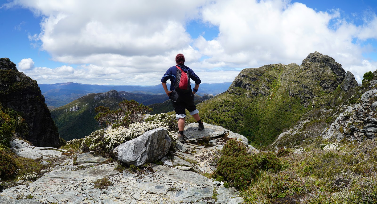
If there is anything I've learnt from my aborted attempt at the Stirling Ridge Walk, it is that you can't rely on weather forecasts for mountains. Sure, the weather might say it will be sunny or partly cloudy, but that fine weather might come much later or earlier in the day, and you might wake to find yourself in low visibility, high winds and driving rain instead. Therefore, you've got to take whatever good weather you get when you get it, and this is exactly what led to Alissa and I decided to tackle the Frenchmans Cap summit in the afternoon after our ascent from Lake Vera to Lake Tahune. As you can see, Alissa wasn't super excited about another 466 metres of ascending but with partly cloudy skies and it being the summer solstice, we just had to seize the day.

The track to the summit runs behind Lake Tahune hut as it head along the lake. The area surrounding the lake is the very definition of lush, with Pandani, Scoparia and pines dominating the thick vegetation.

With the dense foliage obscuring most of the view, a gap in the trees provided us with outstanding glimpse up to Frenchmans Cap, with its 500 metre sheer face is clear view.

After a short easing in along the lake, the track begins its steep climb to the summit.

To begin with, the track is fairly uncomplicated walking as it is basically a continuous ascent via a series of stone steps.

The climb is rewarded by spectacular views along the ascent. Looking back at Lake Tahune, you can see why this place was referred to as an Elysium on Earth as it is absolutely beautiful. A classic cirque lake, Lake Tahune provides walkers with something of a taster for what it must be like to visit Lake Oberon in the West Arthurs.

Continuing along the ascent, the vegetated slopes are filled with Pandani and Pine trees. With most of the pines in the area having been wiped out but the 1966 fires, it is heartening to see so many had survived on this side of the cirque. The pines gave off the area a Christmassy vibe, which was rather apropos given that we were three days off from Christmas Day.

As were ascending the stairs, it looked as if the track was heading towards a saddle between Frenchmans Cap and the Lions Head. As the track reaches the top of the climb, the track curves to the left towards the saddle, but then continues curving around the rim of the cirque. The views from this curving stretch of track are outstanding, and it is well worth it to stop for a moment and take it all in if weather and visibility are conducive.

Passing a small creek that flows down into Lake Tahune, the track heads along a broad shelf beneath the sheer cliffs of the mountain.

From this vantage point, Alissa and I could clearly see that the saddle looked like it did have a track going up the scree slope in years past, however erosion damage had obviously led to its closure in the intervening years. Instead of this steep climb, the track is now a continuously zig-zagging series of switchbacks up the mountain.

Walking along the shelf, Alissa and I could see the hut and associated facilities below. Tassie Parks and Wildlife have done a good job with making the hut fairly unobtrusive, and we wouldn't be able to see the hut at all the further up we went.
Even though we had a lot more vertical gain to go, the views from the shelf were outstanding thanks to the Lions Head to the left, Pine Knob in the middle and the unnamed peak to the right.

As the track heads southwards, a gap between the unnamed peak and Frenchmans provided views of Philps Peak and the ridgeline that includes the Barron Pass. At the time we didn't know which mountains they were, but it gave us the impression that we were just surrounded by more and more incredibly rugged mountains everywhere we looked!

Just before reaching the gap, the track heads northwards up the mountain.

The track here is much narrower than the shelf below, with the vegetation becoming dominated by more montane heath and less of the trees that were still present on the shelf below.

We were pretty high up by this stage, almost coming into line with the height of the saddle between Lions Head and Frenchmans itself. From this angle, Lions Head began to take on a more obviously peak-like shape.

The character of the walking changed as we reached the junction with the track to the Irenabyss. The Irenabyss track is a 6-8 hour side trip taken up by some hardy folk from Lake Tahune, which follows a track that steeply plunges 1000 metres in 5 kilometres, and then requires the exact opposite climb to return. While I understand the views of the Franklin River are superb, I wasn't feeling quite that masochistic, and we instead just continued on up to the summit. From the Irenabyss junction, the main track goes from being a continuous series of steps to requiring scrambling, however the first few scrambles are fairly easy going. Our friend Bonny had told us to expect some scrambling, but that the walking would be easier than climbing Cradle Mountain or Mt Ossa on the Overland Track.

The view from just above the first scramble in another incredible vantage point. From here we could tell that the Irenabyss track headed along the saddle towards Lions Head and then continued along the ridge northwards. Lions Head itself was also at its most magnificent from this point along the track, with its very pronounced peak.

Getting higher and higher above the tree line, the vegetation became more and more sparse along the walk, with the Pre-Cambrian white quartzite dominating the landscape.

Continuing along, the scrambling became increasingly more difficult, but still within the realm of what we had encountered on Cradle Mountain or Mt Ossa.

Making our way up the steep scramble, Alissa and I ran into the two female hikers who were doing a day return trip from Lake Vera. They had just made it down from the summit and were now at the crux of the walk - a slightly tricky scramble that they described as the 'sketchiest' part of the whole ascent.

Alissa is not much of a fan of scrambling or heights, and with rock slick from rain earlier in the day she really struggled to coordinate a series of moves to get up and over the rocks. Eventually, she decided it was just not going to happen and she moved back so I could give it a go. While there are a number of hand holds to use, I had to admit that this was a pretty tricky climb with potential to slip and fall, and I would say this and another slightly awkward scramble to be much more challenging than Cradle or Mt Ossa. I would prove that this was not just my memory painting these mountains in a more rose-tinted light as I would basically run up and down Cradle Mountain in 90 minutes four days later and it was a piece of cake!

Continuing on my own, I was careful to take my time - especially since there were still some scrambly spots along the way. One of these other scrambles was almost as difficult as the one where Alissa had called it a day, and I was dreading coming down it by myself. Another issue that reared its head is that I started to feel increasingly low energy by this point and I realised that I hadn't had enough food for lunch, and that I had foolishly forgotten to pack my muesli bars or a some jerky as a snack. Having chewed through most of my energy reserves, this added to the challenge of the climb and made me go even slower.

Nevertheless, while I was feeling a bit weak and cautious, the walking became more straightforward stair climbs with occasional, comparatively easy scrambles, and I kept thinking about what a privilege it was to be here enjoying the best mountain walk I've done to date.

Something we were warned about by the two female hikers descending as well as a crazy couple we met at Tahune Hut who run from Lyell Hwy to the summit in 5 hours (!) was that there would be a number of false summits, and at every turn of the switchback I wondered when the true summit would come into view. At points along this part of the walk, the track becomes slightly indistinct and it is important to follow the series of cairns that mark the route. There's currently a bit of a zealous hatred for cairns due to the sculptural graffiti of people who make them for no reason whatsoever, however navigational cairns serve a purpose and you should not knock cairns down unless you definitely know for sure that they are not meant to be there.

Continuing up past a few false summits, it was becoming pretty apparent just how high I now was. Lions Head was way below me by this stage, and it is already pretty tall by Australian standards at 1244 metres.

One more rounding of the corner did not reveal the summit, however I had a strong feeling that I was now getting very close to the end.

Sure enough - as the track headed northwards and then around the corner, I saw a large patch of snow just west of the track. The couple who had run to the summit had mentioned that we would know we were almost at the true summit when we saw the snow, and I could see the track ahead of me levelling out to a summit. Meanwhile, the views to the north-west were exceptional. Along the ridge from the Lions Head I could see Lake Nancy, while in the distance I could see the massive Lake Burbury created by the Crotty Dam and the mountains of the West Coast Range.

From there, it was a short walk to the cairned summit. The cairn had been half disassembled in the 1970s, but dates back to 1853. Parks and Wildlife specifically request that this cairn be left as it is, and no one should knock it over or add extra rocks to diminish its historical importance.

The view from the summit is outstanding, and I was really lucky to have a perfect mix of partly cloudy skies while I was up there, with only a light breeze. To the south-east, the views back towards Barron Pass and Lakes Cecily, Gertrude, Magdalen and Millicent were a highlight of the trip, with the ridge from Frenchmans continuing onto the very dramatic Clytemnestra, named after the character from Greek Mythology.


After taking a moment to enjoy the views from the summit, I began the descent of the mountain. Heading down, I was really taken by the beauty of Lake Nancy's classic cirque lake shape. Had I had the energy, I would have loved to have followed the track to Irenabyss, but hunger and tiredness meant this would have to wait for another future visit should that ever eventuate.

The descent of the mountain was fairly easy going, and I was constantly sharing photos with Alissa and friends back home of the stunning landscape I was enjoying. The second of the challenging climbs was easier going down, and the benefit of Alissa not following me is that she was able to help me with foot placings for the sketchy part as it was actually even scarier going down.
Lake Tahune in Franklin-Gordon Wild Rivers National Park #theta360 - Spherical Image - RICOH THETA
Just before reaching the hut, I had a lovely clear view of Lake Tahune and the surrounding mountains. I said to Alissa that if the weather was good the next day I would come back with some trekking poles to make a tripod and take a 360 degree photo. Having the 360 degree camera with me but no tripod, Alissa suggested I should just do it now and just find a spot on a rock to place it. Seeing her point, I took the photo and I was glad I did - little did I know at the time but the weather the next day would take a serious turn for the worse.

Back at the hut, I was glad to have completed the Frenchmans Cap summit, especially given that when Alissa sewed my Overland and Bibbulmun Track patches to my bag she took the opportunity to preemptively sew the Frenchmans Cap patch on as well! Thank goodness as I would have had to rip the patch off had I not succeeded!
Coming as the second part of a day that already included the climb from Lake Vera to Lake Tahune, the journey to the summit of Frenchmans Cap maintained the outstanding standard of the morning with what I consider to be the best and most exciting mountain walk I've done to date. The views of the beautiful Lake Tahune and the surrounding jagged peaks will remain with me for a long time and more than made up for the steep climb and occasionally sketchy scrambling. Together with the earlier ascent from Lake Vera, this would easily rank as one of the best days of hiking I've ever done to date, and the best day of the best multi-day hike Alissa and I have done.


Thanks for sharing your photos and detailed descriptions!!
ReplyDeleteI really enjoyed your photos and commentary. I went up there last week solo in a day trip from Lake Vera. I found those tricky bits that stopped Alissa quite straightforward, but then I hadn't climbed up Baron Pass and to Tahune Hut with a heavy backpack. I tell myself there is always a hand and a foothold on the cairned route, and sure enough there are. Mt Ann is also quite challenging with its difficult hand and foothold climbs. I had climbed that the week before as a warm up.
ReplyDelete