

A challenging unmarked route in the Monadnocks Conservation Park, this simplified version of the Three Mountains Walk GPS Route explores some of the lesser known parts of the park. Initially heading off-track, the route follows the granite-dominated ridge to the spectacular Mt Randall before following the Bibbulmun Track over Mt Cuthbert and Mt Vincent. A spectacular circuit walk in of Perth's best loved parks
Distance: 14.8 km (loop)
Gradient: Alternates between relatively easy, gentle gradients and section of very steep difficult terrain, with some scrambling required
Quality of Path: Ranges from well formed vehicle tracks, informal bush pads and completely off-track sections with no obvious path through often thick scrub. Several parts of this walk are unmarked and map reading skills are essential. The rocky scrambles would be very slippery after rain - extra caution must be taken.
Quality of Signage: Non-existent to Mt Randall; this walk is an unmarked route and map reading skills are essential. Marked from Monadnocks hut to the Sullivan Rock junction. Route information is available from Walk GPS.
Experience Required: Previous Bushwalking Experience Required. This is a navigationally difficult walk that is highly unsuitable for all but experienced hikers who are comfortable with off-track navigation.
Time: 6-7 Hours, including lunch
Steps: Many informal steps, plus some scrambling required
Best Time to Visit: Late Winter/Mid Spring
Entry Fee: No, however access to the GPS file requires a subscription to Walk GPS.
Entry Fee: No, however access to the GPS file requires a subscription to Walk GPS.
Getting There: The trail starts from Herold Rd. Heading down Albany Hwy from Jarrahdale Rd, the suggested parking area is 7 kilometres down the road on the south west side of the road.

With all my regular and vocal distaste for burnt Jarrah, it was recently put to me that perhaps Perth just isn't enough for my hiking tastes anymore. While it is true that my tolerance for Jarrah significantly declined after visiting both the sub-tropical rainforests of Queensland and the alpine regions of Tasmania and New South Wales, I have not written off the Perth Hills as a place for great bushwalking - it is just Perth's lacklustre trail supply that is the problem. With this in mind and very few all day trails of any note left for us to do, Alissa and I once again returned to Walk GPS for another adventure after enjoying the Wooroloo Brook and Wungong Gorge Walks. While our previous Walk GPS excursions explored areas of the Perth Hills we were not necessarily familiar with, this third Walk GPS adventure would take us back to Monadnocks Conservation Park - a bushwalking favourite for Perth residents that is home to Mt Cuthbert, Mt Vincent and Mt Cooke - but on a more remote, largely off-track adventure to see the park's wilder side on the Three Mountains Walk.
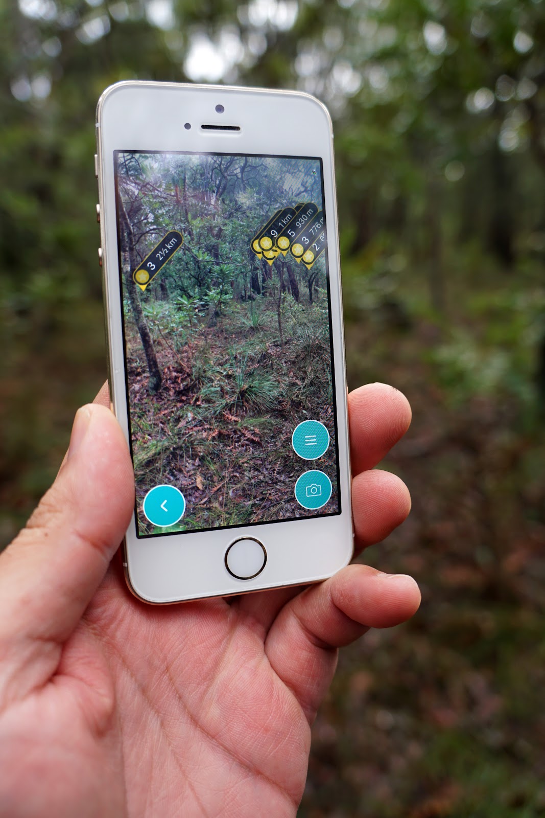
With so much of the walk off-track, Alissa and I once again turned to the excellent ViewRanger app. We had tested out the app on the Wooroloo Brook Walk and used it to map out the William Bay Circuit, and have found it to be an outstanding tool that we would highly recommend. The app's augmented reality function is incredible as it puts markers on the screen, and you can even use the app to navigate to waypoints. It makes off-track walks much less off-track and unmarked than they would be otherwise, and I can't imagine us doing these kinds of walks with as much enjoyment without it.

Initially starting in burnt but acceptable Jarrah forest, it is not long before the track reaches its first stretch of granite. Alissa and I had noted that Dave - who comes up with the walks for Walk GPS - has as much of a love for granite as I do, and this walk is even more granite-dominated than the Wooroloo Brook Walk as the route follows a hilly ridge as it makes its way to Mt Randall.

Being a very wet winter's day in mid-July, Alissa and I were greeted by a lot of wet and slippery granite on this walk, and as such we had to tread very carefully. While the off-track nature of the walk means it is inherently lower impact than the heavily visited sections of the Bibbulmun Track in Monadnocks Conservation Park, the mosses on the rocks are just as fragile and stepping on them should be avoided wherever possible.

Across the top of the granite dome, a faint pad could be seen. Keen to avoid the slippery slope, Alissa and I followed the pad as we made our way to a steep ascent. The view from up here was fantastic - while Jarrah often looks thin, scrappy and frankly ugly in its regrowth state, even the thinnest, youngest and most excessively prescribed burnt Jarrah can look lovely as a whole forest. With the moody, cloudy skies, Alissa and I were really enjoying the scenery even at this early stage.

The next section of steep granite walking would probably have been achievable in drier weather, but what greeted us was a dangerously slippery slope. With no set route, Alissa and I found our way along the edge of the granite slope as we once again followed a faint pad up to the top of the ascent.

Now, while I prefer some of these off-track walks to official trails due to the scenery being far better, I am not a fan of bush bashing as I find it to be frustratingly slow and scratchy going. Once on top of the granite slope, the walk pushes straight through some unbelievably thick scrub that was home to the eminently unlikeable parrot bush. You have to take the bad with the good when it comes to off track walking, and this kind of frustration is the price one has to pay for the outstanding quality of the scenery.

And the scenery really was amazing. Perhaps its because these parts are more remote than the sections of the park that the Bibbulmun runs through, but Alissa and I thought the forests looked less burnt and more beautiful than what we usually see on the track. Sure, the trees had obviously burnt some time in the past, but they weren't offensively so the way they often are along the more visited tracks.

As is to be expected from Dave's walks, the thick brush was broken up by sections of easy walking along the granite ridges with great views over the landscape.

While we did have some more sections of extremely thick scrub to push through, there was also a lot of really enjoyable stretches through some lovely, lush Jarrah. While I find the Karri forest much more impressive overall, the open understorey of the Jarrah forest does make it perfectly suited for off track walking and scenes like the above give me a greater appreciation for a forest type that I feel is harder to love that many others in Australia.

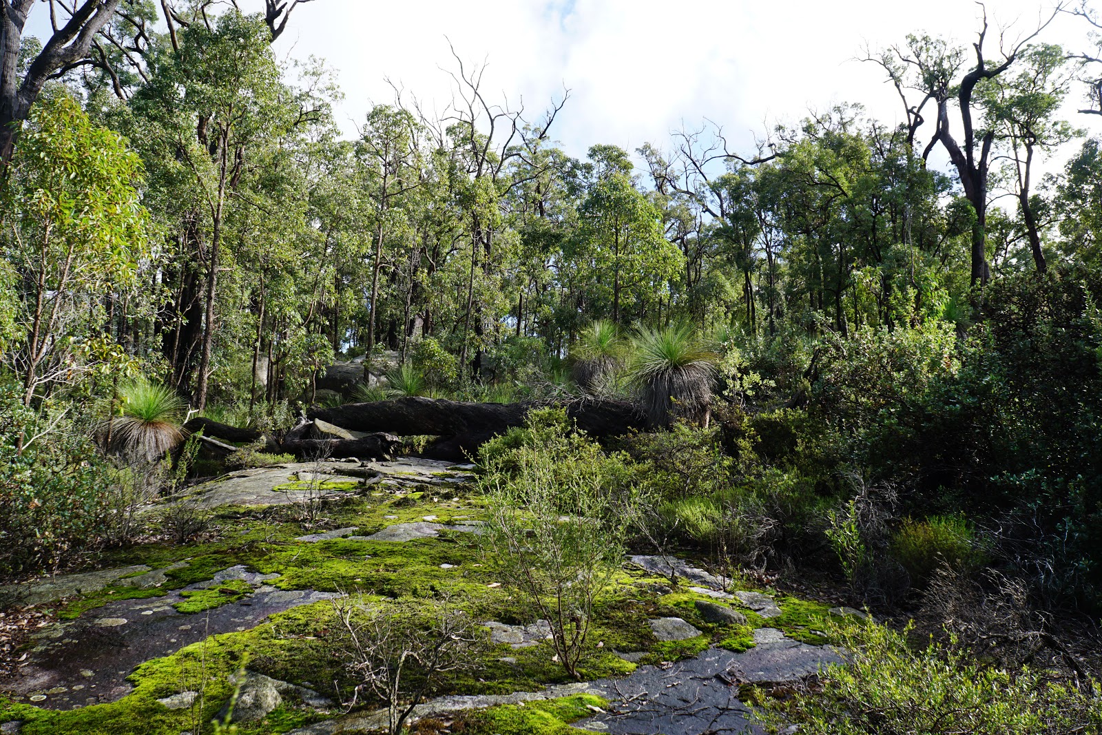
Emerging out from the forest, Alissa and I were delighted to see that Dave's granite obsession delivered yet again with a small but magnificent granite dome providing views of the surrounding landscape. Even when I see granite like this in other parts of Australia, it makes me think of home in Perth, and I wish we as a state did more to maximise the stunning granite-dominated scenery on Perth trails rather than the oversupply of boring forest loops on management tracks with little in the way of geographical interest.

After a section through forest, Alissa and I reached the outstanding climax of the off-track section as we made our way through the largest and most impressive stretch of granite yet.

Following the waypoint markers on ViewRanger carefully, Alissa and I could see that we had to make our way down a few potentially slippery slopes. Above is Alissa showing a safe technique to get down the rocks; if doing this in wet weather, it is best to think about taking it slowly and safely, especially given that it is off-track and difficult to get to in an emergency.

Heading through the lovely mix of forest and granite boulders, Alissa and I reached the end of the granite as we once again headed back into the forests.

To our surprise and delight, we left the granite and only walked through a short stretch of forest before finding ourselves on a vehicle track! After an entire morning of constantly checking GPS and bush-bashing, it was with great relief to be on an actual formed track for a change!

The vehicle track didn't last long, however we left the vehicle track only to follow a walk trail that was actually marked with flagging tape! While I occasionally monitored the GPS, it was glorious to be able to just walk without thinking - a pleasure that would stay with us all the way to Monadnocks hut.

The walking along this stretch was outstanding, with a lot of granite formations along the ascent to the summit Mt Randall. Through the trees we could see a massive granite dome just to our left as we circled around to climb up.

The track rises up and onto the top of the granite dome, which is part of Mt Randall itself. While Mt Randall is unmarked, the fact a trail runs from Monadnocks hut to the summit means this area is much more visited than the earlier parts of the walk, as evidenced by the fact a walk trail break has formed in the moss.

The views are excellent from this lookout point, with Mt Vincent and Cuthbert visible. A great feature of ViewRanger is its ability identify geographic features with arrows pointing out which mountain is which.

From there, Alissa and I went to explore the area around Mt Randall's summit.

While we didn't explore as much as we should have since we were racing the clock to avoid a heavy downpour that was coming, we did appreciate the granite formations near the summit such as the interesting rock above. Why Mt Randall is not marked as a side trip from Monadnocks hut is beyond me - I just don't understand the reason we would deprive people of such excellent scenery.

Following the track again, the walk led us to Monadnocks hut. While I thought I had only visited Monadnocks for the first time in August 2015, I recently discovered that Monadnocks was the first hut I ever stayed at in the Northern Half of the Bibbulmun Track when I walked to Kalamunda from Sullivan Rock in 2004. Monadnocks is definitely one of the great hut locations along the track as it features a great aspect, landscaping and is in the Deep South style that is my favourite hut type.
While we should have been more conscious of the time, Alissa and I ended up staying at Monadnocks for quite some time chatting to a thru-hiker who was three or four days off from finishing the track. A farmer who had just handed over the farm to his son, we had a good chat about the Bibbulmun, and he expressed his opinion that this was some of the best walking of the entire trip - an opinion I share with him as the Dwellingup to Kalamunda section is easily in my top 3 town to town stretches of the Bibb. As is often the case, the Bibbulmun had definitely given him the hiking bug and we gave him a bit of advice about other trails to walk like the Cape to Cape Track and Tassie's Overland Track.

From Monadnocks hut, Alissa and I decided to simplify Dave's walk by not exploring some of the other granite ridges of his Three Mountains Walk route that requires more off track walking and instead stick to the Bibbulmun. This was due to rain starting to fall pretty heavily and the fact we'd spent a lot longer than expected trying to pick our way through the off-track section. As we followed the Bibbulmun, we could definitely see why he decided the track was not worth following - the forest here was boring, severely burnt and was easily the least exciting bit of walking of the day. Due to the fact it rained fairly heavily along this stretch, I had to put the camera away and the above represents one of the better stretches of this section(!). Why the scenery along a walk marketed as 'world class' would be so far below what we'd seen off-track is beyond me.

As we began the ascent of Mt Cuthbert, Alissa and I past the stretch where the Walk GPS route would have rejoined the Bibbulmun. True enough, as soon as I wandered off track I discovered a massive expanse of granite!

Making our way up Mt Cuthbert, Alissa and I were happy to see the burnt Jarrah and She-Oak give way to beautiful, smooth-barked Eucalypts. This stretch of the track features Wandoo and rare stands of butter gums, and was the start of the good part of the Bibbulmun Track walking.

Mt Cuthbert and Vincent are some of the best bits of the entire Bibbulmun Track, so we were very excited to be exploring them again. Slightly disappointing was the disappearance of the famous arrow cairn - a massive cairn made in the shape of an arrow that used to point up the small mountain. While I understand the whole 'sculptural graffiti' argument regarding cairns, I didn't find the arrow cairn to be offensive or harmful and I was a bit saddened to see it go.

While it had rained less than half an hour earlier, the gentle slope of Mt Cuthbert was relatively easy to traverse. The views back towards Mt Randall were excellent, and it was nice to finally put a name to that mountain we'd seen many times along this stretch of track.

The summit of Mt Cuthbert is justifiably celebrated as a highlight for walkers of the Bibbulmun. Back in 2004, I had completely forgotten that we had started at Albany Hwy but I had strong memories of being amazed by incredible views from a high granite viewpoint filled with ephemeral gnamma pools. Even though I've experienced more exciting summit views in other parts of the country, Mt Cuthbert still has the power to make me stop, pause and take in the landscape some 14 years after visiting it for the first time.

From the rocky summit, the route continues along the Bibbulmun as it makes its way to the saddle between Mt Cuthbert and Mt Vincent.

The descent of Mt Cuthbert heading south is actually one of the more potentially dangerous stretches of the track as walkers have to walk along the edge of a steep granite slope. Once false move here could result in a nasty fall quite a way down, and it surprising that this is part of the Bibb given how risk averse Western Australian trails are in general.

The walking in the saddle between the two mountains is pleasant and enjoyable forest walking that goes past a continuous jumble of granite boulders.

The ascent of Mt Vincent is excellent and rugged, with a plethora of granite boulders along the climb. One of the granite boulders forms a perfect lookout point that allowed me capture the above image of Mt Cuthbert and Mt Randall. I was very fortunate to be able to take this photo, as mere seconds later it started to rain pretty heavily as I waited for Alissa to catch up.

While the ascent of Mt Vincent is enjoyable, the summit of the mountain is a bit dull compared to its neighbours. Being heavily vegetated, the summit does not feature great views but can be a pretty impressive riot of colour during wildflower season.

Making our way down the mountain, the wind were intensely cold, however we were privy to a spectacular sight of a rainbow in the distance.

I'm a bit critical of what I see as a heavy-handed approach to prescribed burning in Western Australia, however I must say that Alissa and I quite enjoyed seeing the massive patch of red leaves in the distance. While brought about by fires artificially set by humans for prescribed burning purposes, the red leaves made the area look positively autumnal, and reminded Alissa and I of the beauty of the turning of the fagus we witnessed on the Tarn Shelf Circuit in Tasmania.

At the bottom of the descent, Alissa and I came upon the Bibbulmun River, as the combination of rain and the granite slope resulting in the path being flooded. From here, Alissa and I were meant to go off track and take a short cut, but ended up just following the Bibbulmun to a trail junction we knew well.

The Bibbulmun reaches an old forestry road. Bibbulmun Track thru-hikers would turn left here and head onwards to Mt Cooke, while day visitors would usually cross over and go straight to Sullivan's Rock, where a picnic are and car park make it the perfect place for a day visit. Alissa and I would be doing something completely different this time and would instead by turning right to follow the vehicle track as we made our way back to the start of the walk.

Believe it or not, but this old vehicle track was part of the old Bibbulmun Track. Back in the 1988 alignment, the Bibbulmun didn't bother to rise up and explore the mountains at all, and instead skirted along the bottom. For all the complaints I have about how badly the current trail supply in Western Australia lets down bushwalkers, the situation is nevertheless a vast improvement on how much worse things used to be!

Nevertheless, the views from the vehicle track were quite enjoyable, and it was interested to be able to see Mt Vincent from a different angle to what Alissa and I have become very familiar with.

It was also interesting to see a number of creeks criss-crossing the track. Being in the middle of winter, the creeks were full of water and life, with the forest being filled with the sound of frogs and birdlife enjoying the wet conditions.

At a tree spray painted with the letters 'BT' for 'Bibbulmun Track', Alissa and I turned left and followed the old vehicle track that would lead us back to our car.

After such an excellent walk, it was a bit disappointing to see that this road seems to be a popular dumping ground for the local bogans, with rubbish strewn everywhere in one particular part of the track that was actually marked as being in the Disease Risk Area and not supposed to be driven on due to the potential to spread Dieback. This was a real downer, but was not enough to completely dampen our spirits given all the positive things we'd seen along the walk.
While there were sections of annoyingly thick undergrowth, the Three Mountains Walk was a fantastic circuit walk, and another classic example of how Dave's Walk GPS walks are significantly better than the majority of on-track walks in the Perth region. With such outstanding scenery, it is almost unbelievable that this route doesn't exist as a marked circuit walk on a formed trail as a marked version would have to rank as one of the best walks in Perth.
The answer perhaps lies in the garbage piled up on the road. The fact of the matter is that there are just too many people who don't give a damn about looking after the land properly for us to deserve this being a recognised and managed trail; as soon as a trail went in, the dirt biking riders would be all over this and the granite would be covered in tyre marks and garbage dumping. Sadly, with ever-stretched budgets Parks and Wildlife simply cannot afford to police such repugnant activity and we are stuck with the status quo of limited trail supply, with most of the ones that we are given being boring walks along forestry tracks.
Nevertheless, this scenery is available for those who are prepared to wander off the beaten track. While I would suggest this walk to hikers who are experienced with off-track walking, I really loved this walk and would recommend it. If you're someone like me who has exhausted all that you can get out of the marked trails in Perth, then the Three Mountains Walk GPS Route is one that is definitely worth checking out.


there are plenty of granite outcrops a bit further to the east to Explore anytime, :-) thanks for the great blog
ReplyDeleteWe definitely want to head out and explore this area more as I think there is a lot of potential deep within the park. Thanks for the tip!
Delete