

The longest and hardest day of the Wilsons Promontory Southern Circuit, Little Waterloo Bay to Roaring Meg takes hikers up the biggest ascent of the walk. After walking the white sands of Waterloo Bay, the track rises up along the coastal ridge before descending to a side trip to the lighthouse at South East Point. Heading inland to Roaring Meg campsite, a side trip leads to South Point - the southernmost point of the Australia mainland
Distance: 20.9 km (13.3 km one way for main track + 1.6 km for South East Point side trip + 6 km for South Point side trip)
Gradient: A few moderate descents and ascents with some long sections of steep terrain
Quality of Path: Largely clear and well maintained
Quality of Signage: Largely well signed, with clear signage at trail junctions and major landmarks
Experience Required: Previous Bushwalking Experience Recommended
Time: 7.5 Hours, including lunch and the side trip to South Point
Steps: Several steps along the track, particularly along the ascent and descents from the beaches.
Best Time to Visit: All year
Entry Fee: No, however a camping permit is required for all campsites in the park and must be booked in advance
Getting There: No direct access to this section of the track. This is a walkers only section of the park. Entry Fee: No, however a camping permit is required for all campsites in the park and must be booked in advance

In spite of sharing a campsite with two school groups, I again woke up well rested and ready for another day of walking on the track. With only 13.3 km for the main track and a 1.6 km side trip to South East Point, we were looking at a fairly cruisy day in terms of kilometres. I was looking forward to visiting the lighthouse at South East Point given its resemblance to Bald Head in Western Australia, as well as checking out the massive granite boulders located along the way.
Zach had once again had a poor night's sleep, however he was also rearing to go. Over breakfast, we discussed the possibility of tackling the side trip to South Point - the southernmost point of the Australia mainland - today as well. Our initial itinerary was to get up early on day four, go to South Point in the morning and then pack up and head back out to Tidal River, however we were keen to get back into Melbourne before sunset and tackling South Point today would mean a better finishing time. Zach wholeheartedly agreed, and we prepared ourselves for the longest day of the track.

Heading south along the track, it was really interesting seeing the different vegetation in this part of the campsite. The area looked like it had been landscaped as a garden, and we were not sure if it was a natural occurrence or if these trees were intentionally planted. One tree looked a lot like a type of Lilly Pilly, but not the common species that I've seen in gardens throughout Australia. This tree has certainly left an impression on other walkers, as it was mentioned to me by fellow blogger Kevin from Goin' Feral One Day at a Time when we caught up after the walk.
Passing briefly through a tunnel of heath with occasional views through to the ocean, the track then descends to Waterloo Bay. Immediately upon reaching the beach, Zach and I were confronted with a rocky creek bed right across the track.

Known as Freshwater Creek, the water looked a lot less tannic than what we had encountered at Little Waterloo Bay, and would probably make better drinking water as a result. While the creek is fairly wide further inland, the section across the rocks is an easy hop across.

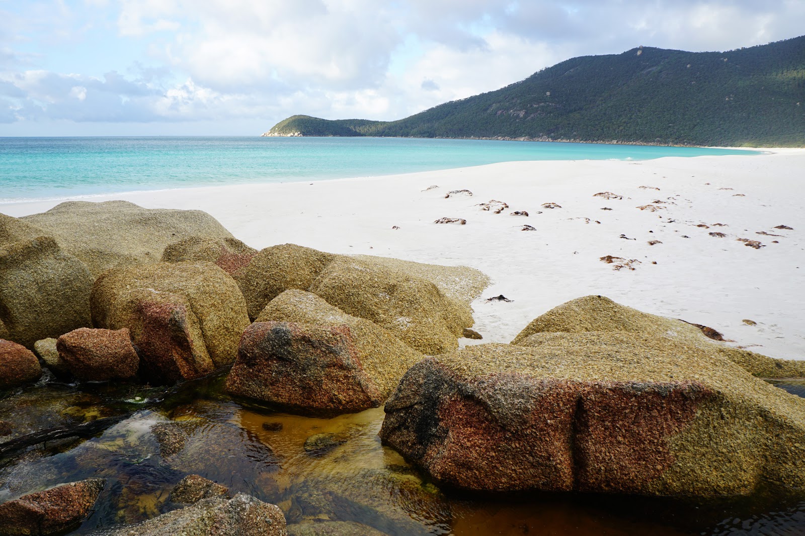
Waterloo Bay's bleach white sand and crystal clear waters made it easily the most Western Australian looking beach of the entire walk, appearing like a part of Cape Le Grand or Fitzgerald River National Park on the other side of the continent. It definitely brought back memories of walking the excellent Mamang Trail with Alissa, especially since Zach and I were enjoying a similarly atmospheric mix of bright sunlight and moody cloud.

Curiously, the track leaves the beach and walks behind the coastal heath for a short distance. This seems designed to take walkers off the beach and to avoid a sand slog, but the fact it brings walkers back to the beach anyway makes this a bit unnecessary.

After following the path behind the dunes, Zach and I reached a junction. For those looking to shorten the circuit and cut out the challenging walking that is to come, it is possible to cut across to Telegraph Junction and head to Tidal River via Oberon Bay or to Telegraph Saddle if that is where the car is parked. While this shorter circuit misses out on some of the outstanding coastal views we would encounter on this day, we would both be wishing we had taken a shorter route as the walking would become increasingly difficult once we left the beach.

Looking at the hills ahead of us, I joked to Zach, "how terrible would it be if the track kept going up and up straight over the hill?" While it was not quite as steep as that, the feel of the next few kilometres were not far off.

About 50 metres before the end of the beach, a series of stone steps lead off the sand and back onto a formed track.

The mix of low Eucalypts and grass trees made the area look a lot like Western Australia, with the trees resembling the stunted Jarrah that sometimes grows along the coast.

After crossing a creek, the walking became increasingly steep. When I look at the elevation graph, the gradient actually seems pretty easy going, and should have been easier than the 600 metre elevation gain over the first 2.5 kilometres of the Walls of Jerusalem Circuit that I had just a month ago. Perhaps it was because Zach and I were a few days into the walk and our energy reserves had been burnt off, or because I'd been quite sick with a respiratory infection in the first week of May or because I was carrying both a tent and the stove when Alissa and I would normally share the load, but I felt absolutely crushed by this ascent.

At one lookout point, I felt so low energy that I said to Zach that I just needed to stop and eat something. I grabbed a block of Lindt Salted Caramel Chocolate I was carrying and quickly devoured a number of squares. Given Zach's insufficient caloric intake, he was feeling much the same and gladly accepted a few squares himself. I also grabbed a bag of jerky I was carrying and put it in my front compartment so I could had an easy to reach snack if I was feeling low energy again.

While we felt really low on the ascent, the scenery was actually quite stunning. Given the wet climate, the granite boulders were covered in a layer of green moss that would normally be dead and brown in Western Australia at this time of year. The climb became increasingly rugged as we made our way up, culminating in a cruel series of switchbacks that finished off the climb with a steep bang.

Now that we were on top of the ridge, Zach and I were ready to taste the fruits of our labour with some excellent views to the south. We were definitely getting closer to South East Point now, and we could make out many of the buildings surrounding the lighthouse. With the track being mostly downhill from here, we were hopeful that we would make up for some of the lost time from the climb up.

After providing us with spectacular views, the track enters a tunnel of heath. While not very scenic, the flat to slightly downhill walking was easy, and we were motoring along at a brisk pace.

Zach and I were definitely beginning to get an understanding of how the Wilsons Prom ecosystem works as our descending predictably brought us down into some fairly lush forests and enjoyable fern-lined forest walking.

Some sections of forest were a bit burnt and on the scrappy side, however there was a really wonderful moment as we were getting close to South East Point when we rounded a corner and were greeted with the beautifully dense and healthy looking forest pictured above. After feeling frustrated on the climb up, it was nice to be rewarded with a view like this as we made our way down to the lighthouse junction.

As the dense forest gave way to more coastal vegetation, Zach and I were pleased to see that we were very close to the lighthouse and could actually make out the path that leads up to South East Point. This meant the junction would not be too far away.

A low key point hidden by a grove of trees and marked by a large granite boulder, the junction to the lighthouse was a perfect spot for Zach and I to relax and have our lunch break. While we were eating, I noticed a few crows in the trees nearby eyeing us off. A few crows and magpies had been keenly watching us at Little Waterloo Bay the day before and had stolen a wrapper from a muesli bar Zach had just eaten. I warned him to not have any food items in zipper compartments as crows are pretty smart and know how to open zips. He assured me that there was no food in his zip compartments, and we left our packs behind at the junction as we went to explore South East Point.

Walking without a pack was absolutely glorious, it is amazing how your body gets accustomed to a full a pack and when you take it off it feels like you can almost float!

Perhaps due to the steepness and to prevent erosion, the track up to South East Point is a sealed track rather than a more wild trail. Along the way, signs provide information about the history of South East Point and the lighthouse that sits upon it.

Of greater interest to Zach and I were the massive granite rocks towering overhead to the left of the track.

Being avid fans of scrambling, Zach and I had some good fun climbing and rock hopping around the place. This was the best part of the South East Point side trip for both of us, and is something I would recommend to hikers who may not be going all the way to the lighthouse.


Although short, the track up to South East Point is pretty steep and we were very glad to have not brought our packs with us. Earlier, Zach had been hesitant about leaving his pack at the junction out of fear of someone stealing his stuff, but he admitted that the very small risk of theft was better than the alternative.

South East Point is filled with a number of quaint cottages that can be booked for a more luxurious alternative to camping in the Prom. A cool aspect of these cottages is that they can only be reached on foot, so there is still a great sense of remoteness even with the facilities. Being between jobs and with Zach being a student, I had not considered the cottages for this stay given they are more expensive however I would consider it if I returned to do the track with Alissa as I can imagine that she would have loved it.

With Zach's insufficient supplies and my realisation that the Camper's Pantry freeze dried dinner I had for the night actually said 'serve with rice' (i.e. supply your own) rather than 'served with rice' (i.e. included as part of meal), we were both really hoping for some kind of kiosk out near the lighthouse. Sadly, no such facilities exist out here, and Zach was really disappointed as he knew this meant going hungry for dinner. Overall, the lighthouse was okay - I've seen better in Western Australia on the Cape to Cape Track and on Rottnest - and other than checking out the cottages there is not a lot at South East Point to explore. Given that it looks like Bald Head, this was a real shame as I had hoped it might be one of the highlights of the trip.

Zach and I made our way back to the junction from South East Point, passing the helipad located along the path. When we got back to the junction, Zach and I found our bags had been opened and ransacked by crows. With no food in my front pockets, the crows had clearly given up early, however they had discovered that Zach had left his V can and some other rubbish in his outer compartment and it was strewn all over the path. As Zach gathered all his things, I had a bit of a laugh at the situation as it is the kind of typically comical thing that would happen to Zach as he wouldn't have thought that his garbage might attract a bird thief.

From the junction point, the track rises slightly and then follows along the hillside. While about the same gradient as what we had encountered earlier from Waterloo Bay, the ascent was about half as long and felt significantly easier.

The views from this section of the track were outstanding. While there were section of tall heath and forest, there were a number of times when we were provided with clear views of South East Point and other formations along the coast, as well as back across the small mountains and hills of the Boulder Ranges.


While I was feeling a lot better than I had earlier in the morning, Zach's energy levels were definitely feeling the effects of lower than required calorie intake while doing a high calorie-demanding activity like a multi-day hike. While I stopped to take photos, Zach made use of the granite slab we were standing on to have a bit of a lie down.

Still, with the side trip to South Point on the cards, we were pushing on at a fairly rapid pace. With our campsite at Roaring Meg being the most inland of our hike, the track swings away from the coast and entered an area of dry wildflower-filled forest that would not look out of place in Western Australia. The walk trail descends to a vehicle track which is then followed north for a short distance. Other than the first 3.5 kilometres on the first day, this was our first bit of vehicle track walking. If Alissa had been with us, I would have made a joke that the track notes said 'turn right onto old vehicle track', which is a common direction in the Bibbulmun Track guidebooks.

The walking along the road continues until the track reaches a junction. At this point walkers has a choice of following the road or follow some nice single file walk trail that veers off to the left. Why anyone would choose to continue on the road is a mystery, and a cursory look at the map makes the road look like a fairly winding and uninteresting way to go.
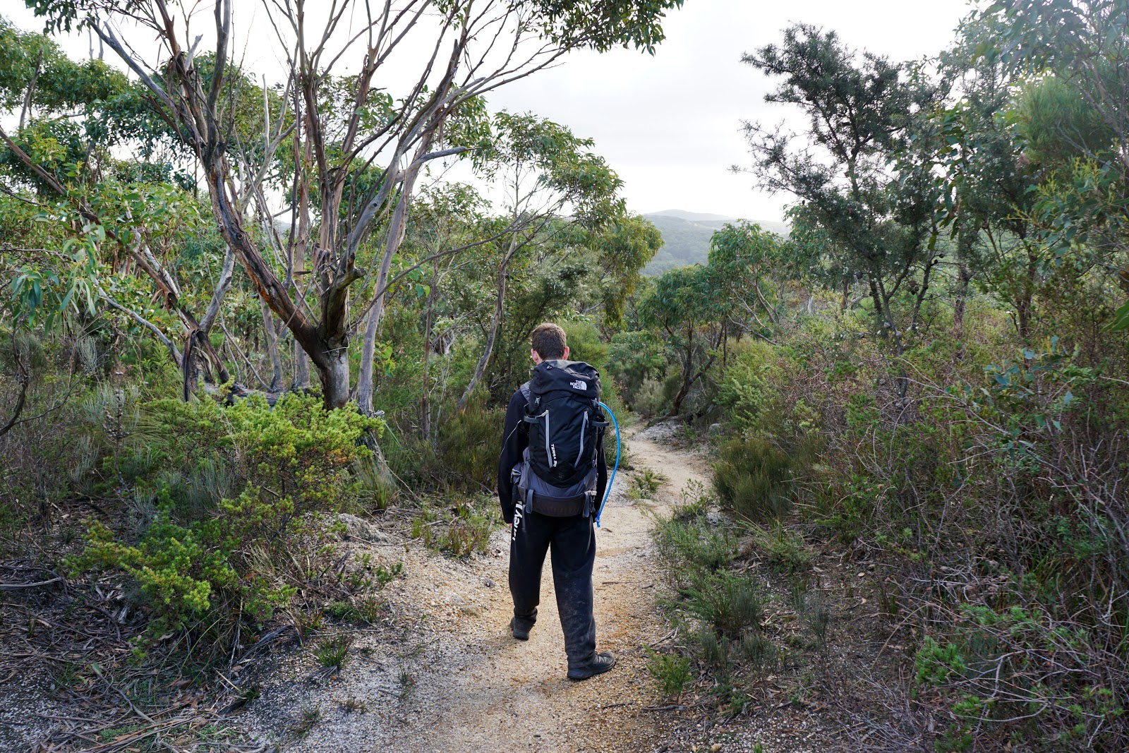
The single file walk trail is mostly a pleasant descent, and Zach and I were powering along the track at a cracking pace as we were keen to get to camp as soon as possible.

Just before reaching Roaring Meg, the trail throws two speed bumps in the way of walkers. Two short but steep hills have to be ascended and descended in quick succession. While short, these were quite tiring and at the worst time mentally as we were so close and yet so far.

Crossing over a fern-lined creek via a nice wooden bridge, Zach and I were glad to know that we had reached Roaring Meg campsite.

The signage at this end of Roaring Meg is not overly clear, and it looks like this is the extent of the campsite. There are some good tent sites right by a creek, and we initially thought of setting up here as it was right by the water. Given the long day, I had used up most of my two litres of water and used the opportunity to fill up my bottles straight from the creek. The water here was the best of the entire trip, being the clearest and nicest tasting of any campsite.

The lack of tables at the sites near the river were a bit of a negative as Zach and I found them to be very useful when it came to rolling up our tents without getting them muddy. As such, we decided to investigate if there were more sites elsewhere in the area. Following the path that merely indicates that a toilet is uphill, Zach found upper campgrounds and we moved our gear there. While I liked Roaring Meg, the fact you have to choose to be closer to the toilets and have a table up top or be near the water down below means you'll be inconvenienced one way or another as it is a 100 metre walk between the two areas.

While lacking the beautiful creek, the upper campground has its own charms with a lovely aspect facing a beautiful stand of forest. It is also very close to the start of the South Point side trip, which is said to be a 7.4 kilometre return trip compared to the 6 kilometres in Chapman's notes!
As you can probably tell from the photo, Zach was pretty exhausted from the day's walking, and with no dinner in his future he was not keen to do the walk to South Point. While tired, I still had the will and determination to get to South Point as it seemed crazy to be only 3-3.7 kilometres away from the southernmost point of the mainland and not check it out.

After setting up our tents and getting everything sorted, I grabbed my small day pack, some water, a snack and my PLB and headed out for the side trip to South Point. The terrain through the forest was initially very similar to what I would expect from the Karri forests back in WA, with a lot of moss covered boulders and ferns along the trail.

Emerging out from the forest, the track traverses a number of granite slabs which offer great views of the rugged southern coastline.

While this was nominally a coastal experience, the walking across the granite reminded me a lot of the small granite peaks of Monadnocks Conservation Park in the Darling Scarp close to Perth on the Bibbulmun Track. As this is one of my favourite sections of the Bibbulmun, I was really enjoying the scenery along this side trip.

Descending on one side of a granite slab, the track looked like boulders had been glued down to create a bordered path. This actually looked similar to a formation I had seen on the Bibbulmun when descending from the White Horse Hills but is sadly not on the blog for a comparison.

As I continued along the track track, I could see Rodondo Island off the coast. A massive granite dome out to sea, Rodondo Island reminded me a lot of Chatham Island off the coast from Mandalay Beach in Western Australia.

The track descends through a rugged, granite-sided valley as it follow a dry watercourse.

Being a fan of rugged landscapes, this was a fun and enjoyable part of the walk. Even without seeing South Point, I was feeling like this side trip was the best part of the day.

As I reached South Point, I was extremely fortunate to find the sunlight take on the charismatic hues of golden hour as it bathed the granite headland in its warm glow. Having been underwhelmed by the easternmost point of the mainland at Cape Byron, I was glad that South Point was an absolutely beautiful location. With numerous islands off the mainland, the waves crashing against the granite coastline and golden hour providing that extra special magic, this was one of those great hiking moments I always hope to find on a track, and was easily the highlight of the entire Southern Circuit for me.

After enjoying the scenic views, I made my way back to Roaring Meg. As is to be expected given that getting to South Point was a descent to the coast, it was all uphill back to the campsite however it was not as hard as I had feared. It definitely made me feel a lot better regarding my fitness considering how destroyed I felt earlier in the day, and I managed to do the journey to South Point and back in 90 minutes.

Little Waterloo Bay to Roaring Meg and the two side trips was easily the longest and most arduous day of walking of the entire Southern Circuit. While there may have been circumstantial reasons that made it harder, the ascent from Waterloo Bay to the top of the headlands was the most challenging section of walking we encountered for the whole trip, and was a bit of a shock to the system after the first two days had been relative easy going. In spite of the challenges, the beautiful forests and being able to scramble around the giant granite formations on the way to South East Point made for enjoyable walking, and I really enjoyed Roaring Meg in spite of its more inland location. The highlight of the day and the circuit as a whole was the trip out to South Point, as the rugged granite landscape and the incredibly rewarding final view at the tip of the mainland made the entire venture worthwhile.


It's great to see and read about the circuit through someone else's eyes Donavon, I've been there so many times I take it for granted a little I think. That's fairly tough day from Waterloo over to Roaring Meg, especially with the two side trips. I'm looking forward to the last instalment. Cheers
ReplyDeleteI think we all have a habit of discounting how amazing where we come from is to outsiders. Yes, it was definitely a tough day with the side trips, but I am so glad I didn't miss out on South Point as it was absolutely magnificent!
Delete