
Distance: 12 km (loop)
Gradient: A mix of a steady continuous ascents with some steep ascents and descents leading in and out of the ridge
Quality of Path: Generally clear and well maintained trail with constructed steps, though some of the ascent section is a bit rough and overgrown
Quality of Signage: Trailhead does not provide clear info about the Mt Rosea Loop itself as the Loop seems to no longer be supported by Parks Victoria. Walkers unsure about the loop are advised to follow the return walk up the mountain instead as it is more clearly signed
Experience Required: Bushwalking Experience Recommended
Time: 4-5 Hours
Steps: Many steps in places, particularly leading up to the summit
Best Time to Visit: Autumn-Spring, except on very hot, windy or stormy days
Best Time to Visit: Autumn-Spring, except on very hot, windy or stormy days
Entry Fee: No
Getting There: The trail starts at the Rosea Car Park. From Halls Gap, take Mt Victory Road into the range and follow the road until the left turn onto Silverband Rd. The Rosea Car Park is to the right side of the road and is located after the turn off to Sundial Rd/Sundial car park. 
Having started the year with adventures in Queensland, New South Wales and Tasmania before coming home to Perth, Alissa and I have been making the most of an excellent winter to reacquaint ourselves with the Perth region thanks to fruitful visits to Rottnest and following the off-track routes of Walk GPS. During this time, I've been flying back and forth for work in Melbourne but have not made the most of this opportunity to go out an explore since I don't usually spend my weekends in Victoria. With a two week stint in Melbourne and with Alissa able to tag along thanks to school holidays, we decided to return to the Grampians to tackle some of the walks that were on our wishlist last time but that we didn't get to explore.
First up was Mt Rosea. One of the dominant peaks near Halls Gap, the imposing mountain commands pride of place as one of the most well regarded mountain walks in the area and was a walk we nearly did last time we were here. Having Glenn Tempest's Day Walks in Victoria, Alissa and I settled on doing a shortened version of the Mt Rosea-Sundial Peak Circuit by cutting out the Sundial Peak section and using a linking trail to just do the Mt Rosea section of the walk by starting at the Mt Rosea car park.

Since Tempest published his book, sections of the Grampians Peaks Trail has been constructed and he astutely notes that conditions might have changed on the ground. Sure enough - based on his notes, we should have been able to park at the Mt Rosea car park, cross the road and follow a trail that would link to the other side of Mt Rosea. Instead, the road led to what appeared to be a dead and at an incredibly well constructed campsite.

This was one of the Grampians Peaks Trail's campsites - the spectacular Bugiga Hiker Camp. Seemingly taking its design aesthetic from the Overland Track (albeit without a hut), this has got to be one of the most impressively landscaped hikers' campsites I've ever been to, and suggests that the Victorian Government have lofty ambitions for this trail to be one of the country's best. It is a shame then that the walk seems to be delayed again and again, with only a three day stretch of the ambitious fourteen day adventure currently available to walk.

Nevertheless, what we did see looked extremely promising, with tent sites overlooking the mountains in a fashion not dissimilar to Bert Nichols hut on the Overland overlooking the Du Cane Range.

Unable to find the track that would have linked us to the other side of Mt Rosea, Alissa and I instead followed the road. Road walking is never ideal, but with shaded forest and mountain views it was far from the worst road walking I've done.

Along the road, Alissa and I kept an eye out for the start of the walk track up the mountain. This track initially follows a management track that is protected by a solid gate.

The management track soon gave way to a slightly overgrown and obstacle-filled walk trail. It is obvious that this is the less explored side of the mountain, and it is telling that the tourism map doesn't even mention this track as an option.

In spite of being the road less travelled, Alissa and I were happy to see markers pointing us in the right direction as we began a long, steady ascent to the summit.

The early part of this ascent was the more eventful. The track offered us occasion views of the surrounding landscape and gave us some indication of how high up we were.

Also of note were the wildflowers. The Common Heath was in bloom along the track, and while having a superficial resemblance to the Mountain Bells of the Stirling Range are actually only distantly related. Nevertheless, the Grampians are home to some montane heath communities that are most closely related to plants in the Stirling Range, which is incredible when you think they are two mountain ranges on opposite sides of the country!

As we continued along, the views from the track diminished as the forest grew deeper and denser. Being used to the low heath and mallee of the Stirling Range, it was a bit of a surprise to see such dense forest growing on the mountain's slopes. Upon reaching a junction in the trail, Alissa and I followed the sign as it pointed us towards the summit.

The walking along this stretch was far from thrilling as it was mostly a steady climb with little views. The steepness did increase as we continued as it followed a series of switchbacks up the mountain.

The forest walking wasn't really that bad, it was just that there was a lot of it and the trees blocked a lot of the mountain views. Every glimpse we would get through the trees would be a savoured as we were really looking forward to the mountain views the Grampians are famous for.

The appearance of large boulders along the track were a good omen, and heralded the start of the rugged mountain walking section of the track.

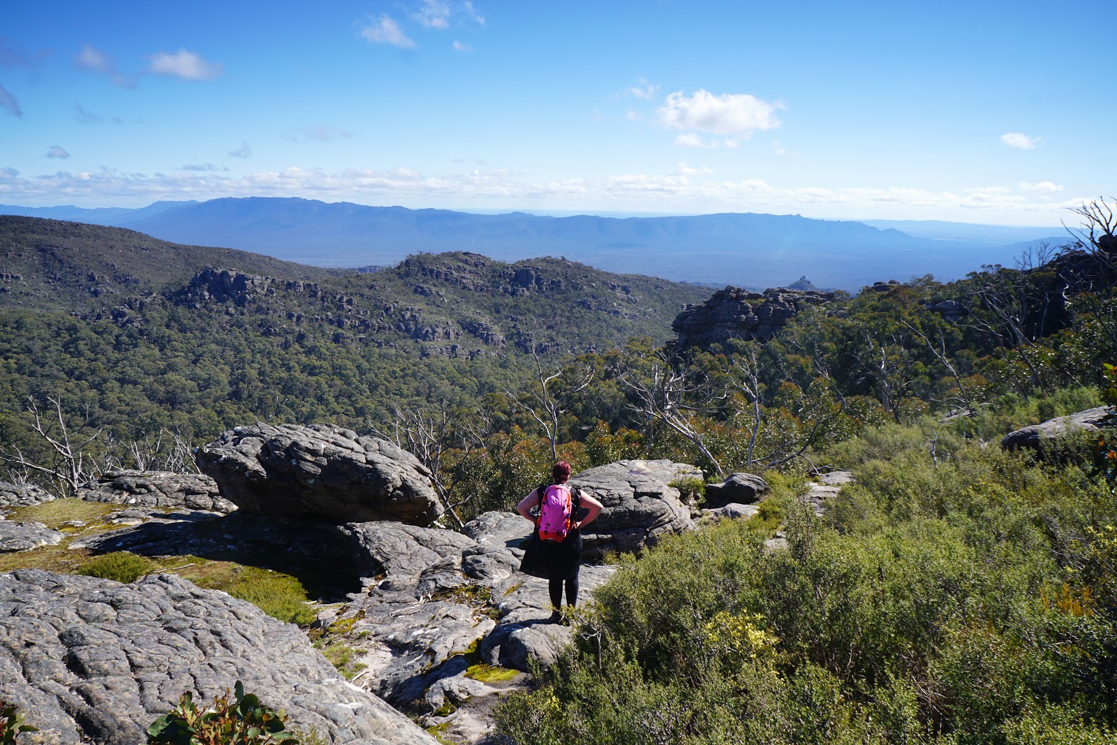
Breaking through the tree line was a real treat - finally, Alissa and I were able to look across the stunning mountains peaks of the range, and gave us that extra boost of enthusiasm after some seemingly never ending forest walking.


The track here is very well constructed, and has probably benefited with upgrades due to being part of the Grampians Peaks Trail. Nevertheless, it was nice to see that they hadn't overdone it with safety railing. This allowed Alissa and I to peer over the edge to see just how steep the sheer cliffs of the mountain are in places.

We had not yet reached the summit of Mt Rosea, and the views of the surrounding landscape were already mindblowingly good!

Still ascending, Alissa and I continued following the markers through interesting rock formations as we made our way to Rosea's summit lookout point.

Being one of the main peaks of the range, Mt Rosea's summit has a well constructed lookout with a railing and a sign naming all the surrounding peaks.

The view from the summit was exceptional. We could see the lower peaks at the eastern side of the range, the massive Lake Bellfield and the surrounding landscape beyond. This definitely made some of the monotony early on worthwhile.

Having reached the summit, Alissa and I now had to make our way down to complete the loop to the car park. Unlike the more heavily forested walking on the other side of the mountain, this descent was a constantly exciting journey through a rugged landscape.


One of the exciting highlights of the descent is walking through a narrow slot/tunnel-like cave.

The other major highlight is a stretch of the track that crosses over a chasm via a bridge. This reminded Alissa and I of the famous Chasm of the Stapylton Amphitheatre walk in the Northern Grampians, which requires walkers to either take a leap of faith across to the other side or to take a longer way around.

The drop at Stapylton Amphitheatre is a few metres - enough for an untimely death if the leap isn't achieved. This chasm was even worse - the gap between the two sides was considerable, with the drop being even more so!

Across to the other side, Alissa and I stopped to take in the excellent views of the sheer cliffs and pagoda formations of the mountain.

After the bridge, the walking continued in an engaging fashion as it followed an interesting route through the maze of rock formations. There were a lot of moments where light scrambling was required but none of it was particularly difficult. A number of blogs played up the scrambling as being challenging and it got Alissa worried as she was expecting Stapylton levels of difficulty, but what we found was relatively tame and easy going scrambling.


As the rock formations began to give way to more and more heath, Alissa and I were on the home stretch back to the car.

The low heath with its wildflowers definitely brought to mind memories of our visits to the Stirling Range back home in WA, although very few walks in the Stirling Range are quite as substantial in length as the Mt Rosea Loop.

Our days of exploring interesting sandstone formations were not over as we entered the heath-filled sections - there was a really cool stretch through a series of wind and water scoured pillars that were an interesting highlight of this later stretch of the track.

As with the Stirling Range, the number of reptiles sunning themselves on the rocks was considerable, and I was amazed at how close I was able to get to one before it decided to scurry away. These guys are obviously very used to the regular visitors are seem to be less scared of people than other lizards we have encountered on trails.

Looking at the lower hills around us, Alissa and I could see we were well and truly on the home stretch, with the car park being around on the other side of the hill slope in front of us.

As we began to be surrounded by taller trees, we knew we only had a short distance to go. Passing by another Grampians Peaks Trail campsite, I considered checking it out until the thought of another kilometre of walking and a later arrival for dinner made me decide against it. From there it was only a kilometre or so before we were at the car park having completed the loop.

In spite of some monotonous sections on the ascent earlier on, Mt Rosea was a remarkable trail that had so many of the features I love of rugged mountain walking. Once we broke through the tree line to the rocky sections up above, the was almost continuously spectacular and lived up to its reputation as one of the best mountain walks in the area.
While loops are generally preferable to a there and back walk since there isn't a repeat of scenery, the fact is that the ascent on the other side of Mt Rosea is less exciting than the section we descended, and as a result Alissa and I agreed that this would be a far more consistent walk if it were a return journey from the car park following the more established trail to the summit through the rugged scenery rather than making a loop. Regardless, this was an enjoyable walk and one well worth visiting if holidaying in the Grampians.


0 comments:
Post a Comment