

An idyllic day ride, the Collie-Darkan Rail Trail retraces a section of the Bowelling to Narrogin Railway just east of the town of Collie to the town of Darkan. Passing through a mix of forests and farmland scenery, the trail's highlights include a number of well maintained and refurbished wooden rail bridges and two railway stations along the line. Rich in heritage history and rolling green hills, this is an enjoyable day ride with potential for extension
Distance: 47 km (one way, though new extension takes trail to 63 km)
Gradient: Mostly gentle with some minor climbs and descents
Quality of Path: Mostly gravel rail trail and vehicle tracks
Quality of Signage: Good signage at sidings and at crossings in the second half, poor directional signage at some junctions and crossings. Trailheads are clear but could be more informative
Experience Required: Mountain Biking or Bushwalking experience recommended
Time: 3-5 Hours on a bike. 2 days on foot
Steps: None; this is a dual use trail
Best Time to Visit: Mid Autumn - Late Spring
Date(s) Completed: 12th June, 2021
Best Time to Visit: Mid Autumn - Late Spring
Date(s) Completed: 12th June, 2021
Entry Fee: No
Getting There: The Trail starts at the corner of Coalfields Rd and Shotts River Rd. From Collie, travel 18.6 kms east. There are a few Shotts River Rds, so make sure it is the one after the Shotts River crossing. The eastern trailhead is locaed in Darkan, 63 kilometres east of Collie on Coalfields Rd.
Getting There: The Trail starts at the corner of Coalfields Rd and Shotts River Rd. From Collie, travel 18.6 kms east. There are a few Shotts River Rds, so make sure it is the one after the Shotts River crossing. The eastern trailhead is locaed in Darkan, 63 kilometres east of Collie on Coalfields Rd.

Having driven down Albany Hwy countless times in the last decade, it has always amused me that, apparently, all roads lead to a town called Darkan. For a town with only about 400 residents, the town is surprisingly well connected with signed turn offs at Williams, Arthur River and Kojonup, and I've often joked with Alissa we should go for a holiday to this apparently central town. With a trip planned trip Queensland cancelled due to the Delta outbreak and with our plans changed to Electric Bikepacking the Southern Forests, I decided to finally visit Darkan by riding the Collie-Darkan Rail Trail as a warm up before the trip.


Finding the start of the trail was the first challenge. Due to a massive coal mine being in the way, the trail does not start in Collie and instead commences east of the mine. Trails WA had the trail starting at Centaur Rd, and with an obvious rail bridge and form visible on Google Maps, Alissa and I headed to Centaur Rd for the drop off. Arriving at the apparent start point, it was obvious that something was wrong. While there was an obvious rail form, the trail looked horrendously overgrown and there was a lack of a trailhead. Not wanting to be stranded here by Alissa, we decided to drive a bit further down to investigate the rail bridge, only to find that it was fenced up and unusable. Not sure what to do, we decided to drive around to join onto the rail form on the other side of the Shotts River and were relieved to find a clearly marked trailhead a the corner of Coalfields Rd and Shotts River Rd.

Waving Alissa goodbye, I commenced the ride down Shotts River Rd. While this stretch was not actually part of the old rail rail form between Collie and Darkan, the use of this starting point is a reasonable and pragmatic compromise as it was once part of an old timber tramway. Given a trail through the original alignment is probably too difficult now that there is a massive hole in the ground, one imagines the eventual extension into Collie will require a bit of creative license rather than doggedly following the actual rail form.

The trail joins onto the actual rail form at the site of Buckingham Siding. While most of the station infrastructure no longer exists along the trail, the Collie-Darkan Rail Trail has a strong focus on the railway heritage aspect of the route and identifies the locations of the old sidings. Additionally, each siding features clear kilometre information in a similar fashion to the Railway Reserves Heritage Trail in the Perth Hills.

Riding along the trail, it became clear to me that I was not actually riding on the old railway line but adjacent to it. To the right of the trail old railway sleepers are clearly visible, and it made me wonder if the entire Collie-Darkan Rail Trail was actually just on the service road adjacent to the real railway line.

While the kilometre signage is excellent, there are some serious deficiencies in the directional signage along the Collie-Darkan. The first issue occurs within the first few kilometres after Buckingham Siding, with the trail reaching a fork and with no clear indication of which way is the right path to take. Given I knew I had to head east, I assumed the left turn was the correct way to go but these sort of junctions really should be clearly marked so as to prevent confusion.

While my decision to turn left was an informed inference, I was not 100% convinced I'd made the right decision. I was thus very relieved when I came across the signage identifying Muja Siding as it confirmed that I was definitely going the right way. From here, the Collie-Darkan Rail Trail stays largely parallel to Coalfields Rd, varying in proximity along the route.

With all the vehicle track riding I had been doing, I was not sure if I was actually on the form or adjacent to it, however the appearance of remnant tracks at a road crossing confirmed that the trail was now actually on the form itself.

While crossing the road, I couldn't help but notice how flooded the farming landscape appeared. While the area is obviously a flood plain, the water levels were clearly heavily influenced by the torrential downpours that had made July 2021 one of the wettest winter months on record. Water was literally raging as it passed under the road culvert, and turning around and looking upstream showed flooded pastures seemingly all the way along the trail.

The trail stays quite close to Coalfields Rd at this point as it passes the remains of Cowcher Siding. The rail reserve is fairly constrained in this section, with the highway and the farmland being visible through the narrow band of trees, however the road soon veers away from rail trail while the old railway form travels over the wide floodplain.

Given the road remains off the flood plain, it seems odd that the old railway line's route at this point goes directly through the flood waters. The upside of this chosen route is that riders get to enjoy some outstanding wooden rail bridges which have thankfully been maintained and refurbished rather than being left to rot.

This first substantial bridge features a lookout point along the flood plain. Being quite substantially separated from the highway and providing lovely views of the bird-filled wetlands, this is one of the trail's best stretches. An interesting but somewhat unexplained feature of this first half of the trail is that it is co-named the Clarrie Riley Memorial Trail, which I discovered upon further digging was named in honour of one of the key figures behind the Collie-Darkan Rail Trail becoming a reality.

The views of the flooded plains continues as the trail follows a raised section of form. It was obvious that this water level was somewhat unusual as there were obvious fence posts sticking out of the water showing just how deep the inundation had been.
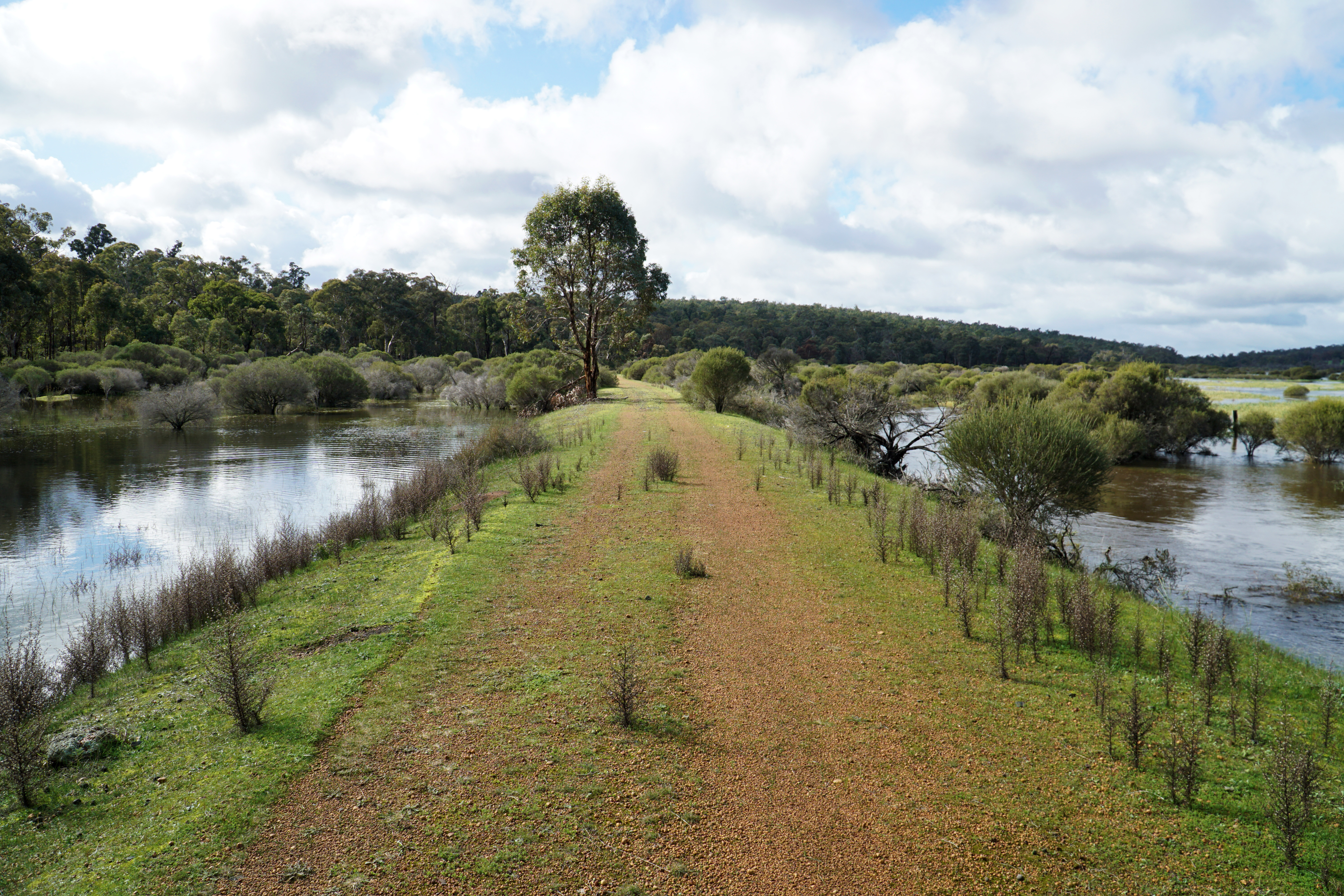
It was incredible seeing the water on both sides of the trail, and the result was the sound of bird song, frogs and insects in stereo as I rode along.

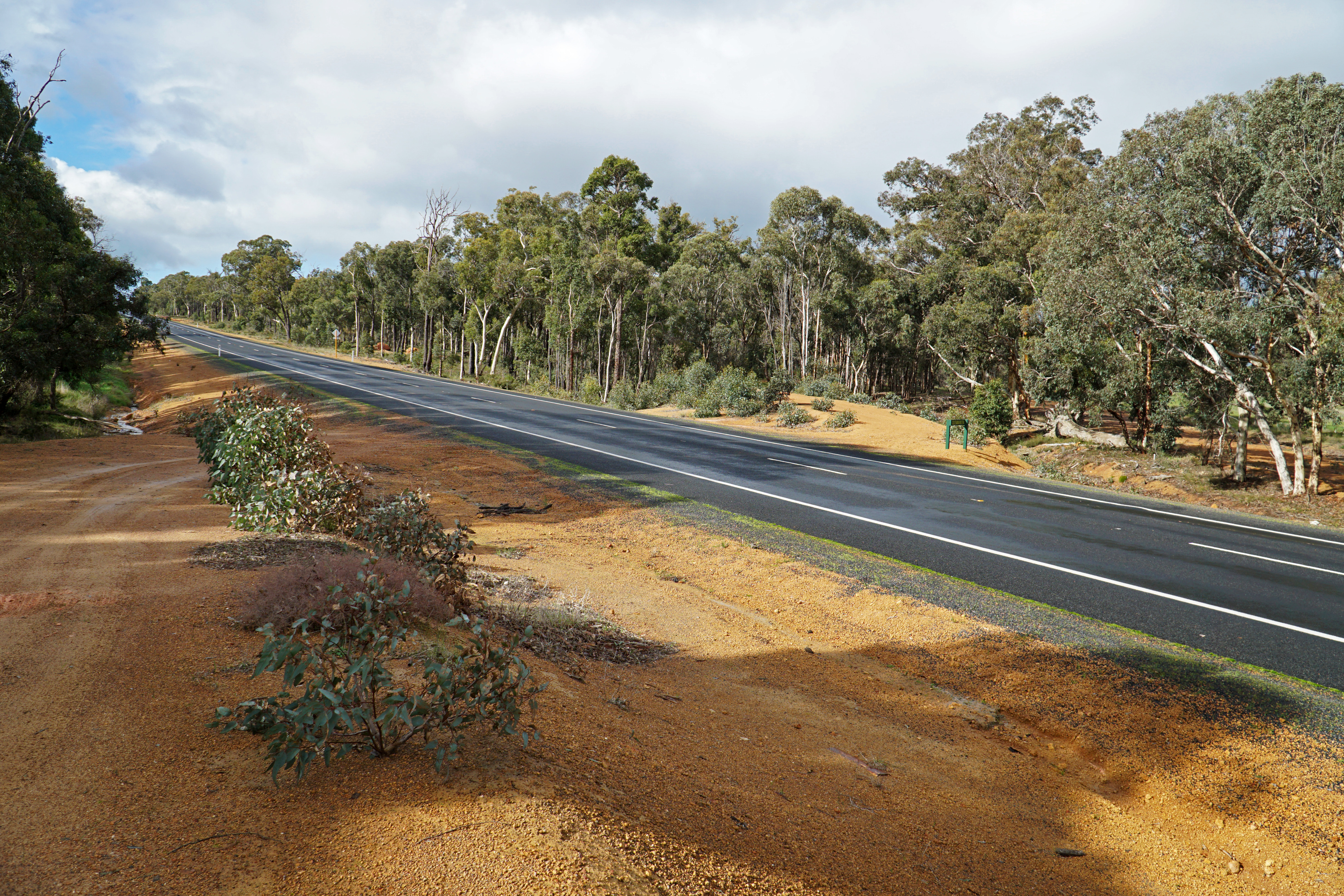
The outstanding section over the floodplain eventually comes to an end as the trail reaches Coalfields Rd. The popular trucking route has recently been upgraded significantly, and this is the sort of upgrade where maintaining a rail form alongside the road can be a low level priority to road construction teams. Thankfully, the Collie-Darkan Rail Trail was not forgotten; while it requires riders to cross the road, a gravel trail runs parallel to the highway and actually provides some fun ups and downs for riders to enjoy.

I have to admit that I assumed the trail was going to just stay along the road the entire time, so I was pleasantly surprised when the form branches off from the highway, with the rail trail continuing to faithfully follow the railway line's alignment.

While I was impressed that the roadworks had maintained the rail form, the trail's poor directional signage was no help when the trail suddenly disappeared at an intersection on Coalfields Rd. It was not immediately obvious where I needed to go, however scouting across the road revealed gravel trail continuing on the other side parallel to the highway, and leading to one of the trail's main highlights.

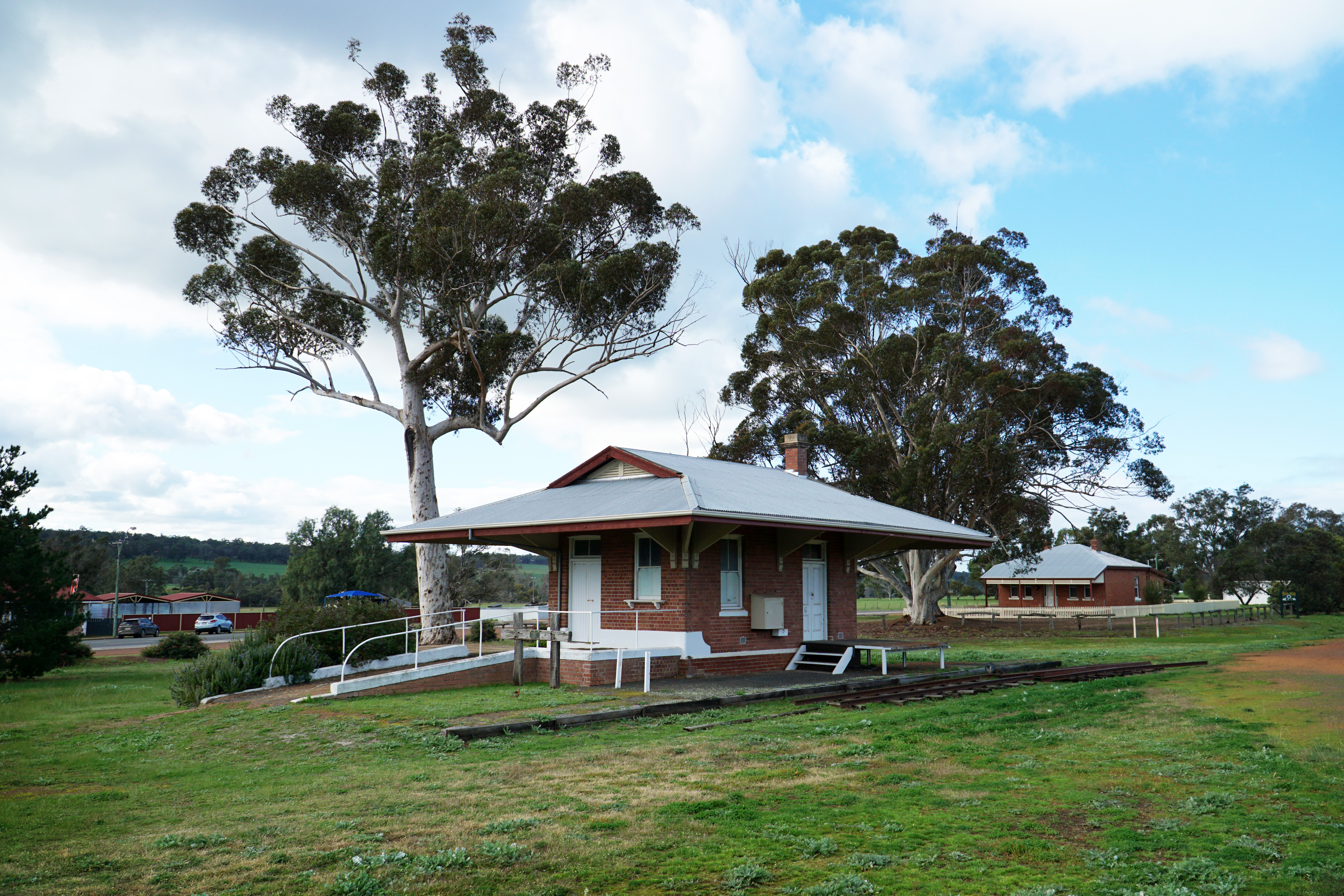
While most of the sidings along the Collie-Darkan Rail Trail are little more than raised piles of soil to mark their locations, the station at Bowelling has been well preserved, and serves as an overnight camping spot for trail users. This is particularly useful for hikers given the trail's distance is probably just too long for most to walk in a single day. Given it is an overnight camping location, Bowelling Station features a water tank, picnic tables and an area for tents to set up under the extended eaves. The only thing missing is a toilet, which makes me wonder where overnight campers are going while staying here!

One of the really impressive aspects of Bowelling Station is that it has been converted into a sort of museum for the trail, with photographs and a timeline providing visitors with information about the trail's genesis and creation.

The station also features a guest book for riders and hikers to sign in, while a heavily annotated copy of the trail's brochure provides more information about the trail. This brochure seems to be out of print as I can't seem to find non-PDF copies anywhere, however it would be great if the trail information contained within could be expanded to a more informative trailhead like those found on DBCA-managed trails.


After taking a snack break at Bowelling Station and topping up my water, I continued eastwards along the trail to Darkan. While not quite as grand, the trail crosses a number of small bridges over short water courses that even at this time of year were running dry. Being a hiker and cyclists, I found it interesting that each bridge featured a sign advising equestrians to dismount as it was not something I would have thought about but makes perfect sense; falling of a horse on bridge would be pretty dangerous and potentially deadly!

Beyond the smaller bridges, the Collie-Darkan continued as a fairly straight ride through thin regrowth Jarrah, Banksias and (non-Royal) Hakeas. This is not amongst my favourite types of forest to ride through, and I was looking forward to either entering more mature forest or some farmland.

Thankfully my prayers to the trail gods were answered as the forest parted and I was once again riding along heavily inundated farmland. With such calm winds and no where for the water to be raging to, the flooded pastures had a beautiful mirror-like quality that made the view appear almost magical. With ducks and other water birds flying in, I just had to stop and take a moment to appreciate the scenery.

Leaving the farmland, the trail again runs close to the highway before diverting away for a more peaceful ambiance as it approaches a wooden bridge over a creek crossing.

The view from the bridge of the flowing creek is quite excellent, and you would not believe that there's a road just a few hundred metres beyond.
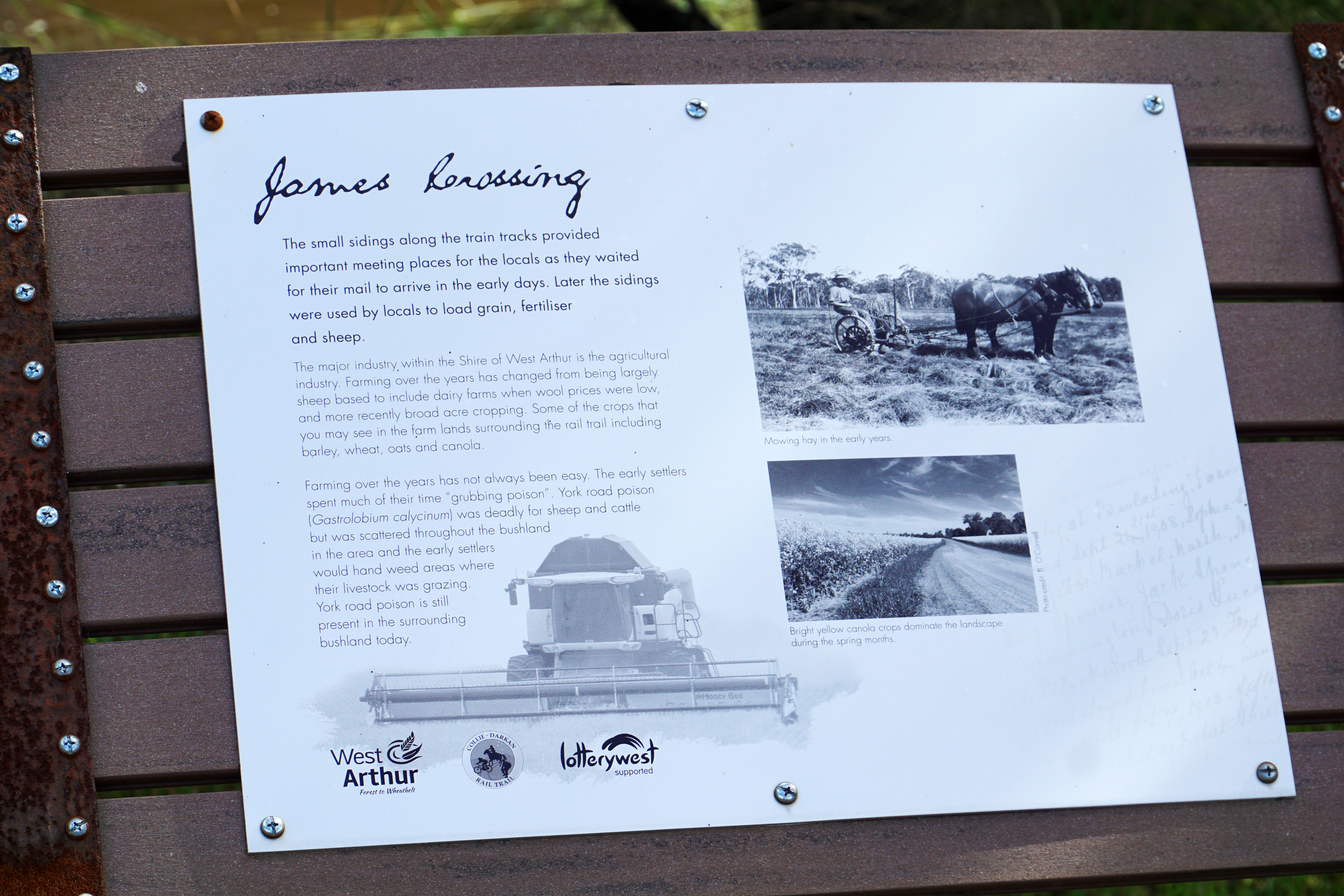
An interesting feature of the trail beyond Bowelling is the appearance of interpretative signage at key points along the trail providing information about the history of the railway line. It looks like the Shire of West Arthur had managed to gain a Lotterywest grant for the signage, which was not coordinated with the Shire of Collie for their part of the trail. This is the sort of thing that I wish was done at an all-of-trail level so that the differences between shires is invisible to the average walker/rider.

The trail's diversion from the highway continues after the creek, with the trail heading along a raised rail form benching that maintains a steady gradient as the trail begins its journey back to the highway.

Reaching Coalfields Rd, the trail crosses over to the north side. Unlike the first half of the trail, the crossings in this second half are a lot better marked, which is a relief given that the trail crosses Coalfields Rd multiple times from here to Darkan.

On the other side of the road, the trail passes through some fairly conspicuous cuttings that make for a cool riding experience given up until this point cuttings were somewhat uncommon along the trail. In a few places there are piles of railway sleepers discarded just to the side of the trail.

The weather for almost the entire ride would be the perfect mix of sunny and cool, however the weather took a turn for the worse along this stretch of the trail. With some initially light rain, I'd resisted putting on wet weather gear but as the rain increased in intensity I stopped to grab a my rain shell and to put the rain cover on my front bag.

The rain didn't last too long, and the riding was pleasant but admittedly a bit nondescript until Boolading Siding. Unlike some of the other sidings along the trail, Boolading appears to be the most intact of the Sidings, with a wooden station platform and a row of mature pines marking the spot - quite incredible considering it was one of the two oldest sidings of the entire line.

Given the better than average condition of Boolading, the siding features a picnic bench for those looking to take a break. With the kilometre signage indicating that Darkan was only 12.6 kilometres away, I was keen to not linger too long and get going as soon as possible.

Beyond the siding there's some excellent mature Wandoo forest that is quite beautiful. The smooth barked appearance of Wandoo makes it one of my favourite Eucalypts, and given it is a slow growing species it really says a lot that many of these trees were of a significant stature.

Reaching another creek line, the trail crosses another excellent wooden bridge. By this stage I'd crossed a number of significant rail bridges, and I have to say I was quite impressed at how the trail makers had managed to refurbish these old wooden bridges. Far too often wooden rail bridges are in a state of such disrepair that they are often unsalvageable, and the result is utilitarian Soviet concrete structures taking their place. The friends group responsible for this trail must thus be commended as this was one of the best aspects of the Collie-Darkan Rail Trail.
Crossing Coalfields Rd again, the rail form continues to pass through forested nature reserve filled with Wandoo and Jarrah.

There are some more cuttings through this section of the trail. Given the somewhat samey nature of the regrowth forest scenery, these cuttings helped provide points of interest in what could have been a bit of a monotonous stretch of track.

Crossing Coalfields Rd and Gibbs Sidings Rd at an odd double road crossing, the trail enters quite a nice stretch of forest riding as it approaches Gibbs Siding. This is the last siding along the rail trail; the next stop is the station at Darkan!

Before reaching Darkan, the trail passes through a private property where the rail reserve has been maintained. This requires trail users to access the property through a farm gate. Given this is a private property, it is important that riders do the right thing and ensure that the gate is properly secured once through as it ensures continued use in the years to come.

The private property features a sustained run along a considerable rail cutting, and the impressive effort that had been undertaken for the railway line construction now meant that riding through here is fast and easy - which is just as well given the scrappy forest is pleasant but not the most exciting views of the trail.

Leaving the cutting, the scenery improved dramatically. Heading along the hillside, the trail provides spectacular views of seemingly endless grassy fields dotted with eucalypts and flocks of sheep. The sunny skies encountered earlier along the walk had returned, creating a truly idyllic and picturesque landscape.

After the farmland scenery, the trail reaches a second gate that leaves the private property, which is followed by the final crossing of Coalfields Rd as the trail enters the home stretch into Darkan.

More easy rolling through rail cuttings ensues on the other side, and given the ending felt like it was just around the corner I was pushing the bike hard by riding above my electric bike's speed limiter.

Clearing the rail cutting, the last few kilometres before reaching the edge of town offer more expansive views of the surrounding farmland. With the green lushness of winter, the area really looked like paradise, and a somewhat novel looking two storey building amongst the trees looked like a perfect retreat or tree change house.

Having reached the outskirts of town, the trail passes by an area that was once offered by the shire council as a permanent camping site for the many Aboriginal people who worked on building the railway line. The campgrounds were closed in 1972 after most of the residents had moved onto larger towns, however the rounded Nissan Hut remains intact to this day, visible just north of the information signage.

Crossing the road near Darkan Primary School, the sight of visible railway tracks were cool to see as it had been a long time since I'd actually seen tracks on the rail form. At this point I really was thinking the end must be around the corner given I was well and truly riding through the middle of town.

Given the proximity to the trailhead I had not expected to cross one more wooden rail bridge, so it was a lovely surprise to see one final bridge within the last kilometre of the day's ride.

The Collie-Darkan Rail Trail reaches the trailhead at Fisher Street, seemingly marking the end of the ride. This is where Trails WA had the trail listed as ending, and where most people with no prior knowledge of the trail would logically conclude the trail ends. It was where Alissa was waiting to meet me, however I knew there was a little bit more to see as the Darkan Station was located a few hundred metres east on the other side of the park in the middle of town.
Or so I thought. Immediately after completing the trail, Alissa and I did our Electric Bikepacking trip through the Southern Forests. After finishing that trip, I was informed that the Collie-Darkan Rail trail was actually extended in the last few years, now running just shy of the old siding at Dardadine. I was kicking myself! Oh well, it will just be something to do next time - and I've heard that there is talk of extending the rail trail to Williams, which will in effect turn the Collie to Darkan Rail Trail into the Collie to Williams Rail Trail - an even more exciting prospect, and full circle given the road sign at Williams was the first time I'd even heard of the town of Darkan!
While there are some shortcomings to the trail given it does not actually start in Collie, the Collie-Darkan Rail Trail was an enjoyable and easy ride through the farmland and forests of this lesser known corner of the South West, made all the more impressive thanks to the inundated floodplains and lush landscapes thanks to riding the trail in Winter. One of the best aspects of the trail is its serious focus on the railway heritage of the area, the number of well maintained wood bridges along the way and the amazingly good condition Bowelling and Darkan Stations remain in. Even better, the trail seems to have a lot of potential for growth; the trail will eventually be extended to Collie itself, and the possibility of it being extended to Williams and possibly even to Narrogin really opens up a world of mix and match possibilities or bikepacking/cycle touring trips through the South-West.


Thanks for another informative write up Donovan. Just wondering if is possible to stay in the Darkin Station too.
ReplyDeleteHi there, I don't think you can stay in the Darkan Station as it was locked and in the middle of town
Delete