
An outstanding Outback mountain walk, the Summit and Gully Trails take walkers to the summit of Mt Augustus - a towering peak that is twice the size of Uluru. Featuring a mix of gentle and steep gradients, the Summit Trail leads to 360° views of the surrounding landscape. With the scramble-heavy Gully Trail filled with waterholes as an alternate, this is an outstanding must-do hike in spite of the potentially deadly heat
Distance: 12 km (return)
Gradient: A mix of relatively gentle and steep gradients on the Summit TriL. Some mild scrambling required near the summit. The Gully Trail is almost continuous, slow-going scrambling
Quality of Path: Clear and well maintained to the summit on a mix of mildly modified and natural surfaces
Quality of Signage: Well signed for most of its length, with the markers supplemented with painted dots on the rock
Experience Required: Bushwalking Experience Required, particularly scrambling experience for the Gully Trail
Time: Allow 5-8 Hours
Steps: Many; this is not wheelchair accessible
Best Time to Visit: Winter, but possible from mid-Autumn to mid-Spring. If tackling in the hotter month, an early start is mandatory. Do not attempt in Summer
Date Completed: 7th April, 2021
Entry Fee: No
Getting There: From Mt Augustus Tourist Park, head north-west on Potts Rd to join onto Cobra-Mt Augustus Rd. Continue on Cobra-Mt Augustus Rd for 7.4 km and then turn left onto Mt Augustus Rd. After 6.3km, turn left at Beedoboodu/Flinstone. Trailhead is located at the car park at the end of the road. To get to Mt Augustus Tourist Park requires a lot of driving on unsealed roads but is possible from Exmouth, Carnarvon, Meekatharra and other surrounding places. Due to the unsealed roads, it is best to check road conditions with the Shire of Upper Gascoyne and surrounding shires before heading out
When people think of the world's biggest rock in the world, most will immediately think of Uluru. While the famous rock in the middle of the continent is arguably the most iconic image of the Australian Outback, a smart-ass Sandgroper would probably point out, "well, actually, the biggest rock is Mt Augustus in Western Australia." That is, until an even bigger poindexter made the distinction between monoliths and monoclines, thus muddying the waters on what actually defines a rock. Regardless of the technicalities, Mt Augustus is said to be as much as twice the size of Uluru and is also located in the Outback, yet is comparatively obscure due to its difficult to get to location in the remote and sparsely populated Shire of Upper Gascoyne (57,939 km2 in size, population 278).

Getting to Mt Augustus is a mission in and of itself, and was made worse by an exceptionally wet season in the Gascoyne region. Due to flooding and road damage, I couldn't get a clear answer about whether the shortcut from Exmouth to Mt Augustus via Lyndon-Minnie Creek Rd was passable, and with the West Lyons River crossing several hours down the road, Alissa and I didn't want to chance it only to have to turn back and go the long way around.
As such we had to take the most reliable route; back down the Carnarvon and then inland via Gascoyne Junction and then via Cobra-Dairy Creek Rd. The drive is quite spectacular in spite of the remote harshness of the scenery, the gravelly unsealed nature of the roads, the high temperatures and the endless swarms of grasshoppers that we were driving through.
While Google Maps does have a tendency to overstate the time it takes to travel on gravel roads, it was a nevertheless a long day of driving. As such Alissa and I were glad when we reached the entry sign at Mt Augustus Station - even though there is still more driving to do to get to the actual Tourist Park, which we found to be a really lovely place to stay in spite of the somewhat basic nature of the accomodation.

While the rock is visible from at least one hundred kilometres away, it was all the more awe-inspiring driving past it on the way to the Tourist Park. Rising up over 715 metres from the surrounding plain, it is an impressive sight to see and had me excited for the summit walk we would be undertaking the next day, though the daily temperatures in the high 30s/low 40s had me concerned.
See, just six months earlier, three people had died doing this very walk, something that has also occurred on excellent trails we have done north of Perth like the Badjirrajirra Trail in Cape Range National Park and the Loop Walk in Kalbarri National Park. All three walks are located in rocky areas with little to no shade where the radiant heat can exceed 50°c, making heat stroke and dehydration a real risk. Given the fact most tourists like to enjoy a sleep-in while on holidays and aren't out and about until 10am, the combination of a late start and the heat can be a deadly combination, but it is one where the risk can be very easily mitigated by an early start.

Given that DBCA suggests to allow 6-8 hours (and used to suggest as little as 5 hrs previously), Alissa and I worked backwards to figure our what time we wanted to start. Given we are very experienced hikers with experience hiking in arid regions, we decided that 6 hours was probably enough of an allowance for us to complete the trail, and given we wanted to finish no later than 11am at the worst, we would need to start by 5am. To give us a little more walking in the cool before sunrise, we agreed on a 3:50 am wake up to allow us 40 minutes to get ready, eat a quick breakfast, camel up with some ice cold water and drive to the start of the walk for a 4:30 am arrival at the Summit Trail car park. Starting a walk in darkness with head torches is not something we would usually do (I can only recall doing it once before, on the second day of the Tongariro Northern Circuit), but if you want to do a walk like this in the hotter months these are the measures required.

Given the deaths in the park, DBCA have put a massive warning sign right at the start of the walk, providing a clear warning that people have died on this trail, as well as advice about the minimum requirements to undertake the walk. There are times I've found the risk warning signs on DBCA land to be comically over the top in their specificity (Bee Risk Area, Abandoned Well Risk Area), but this one is pretty much spot on.
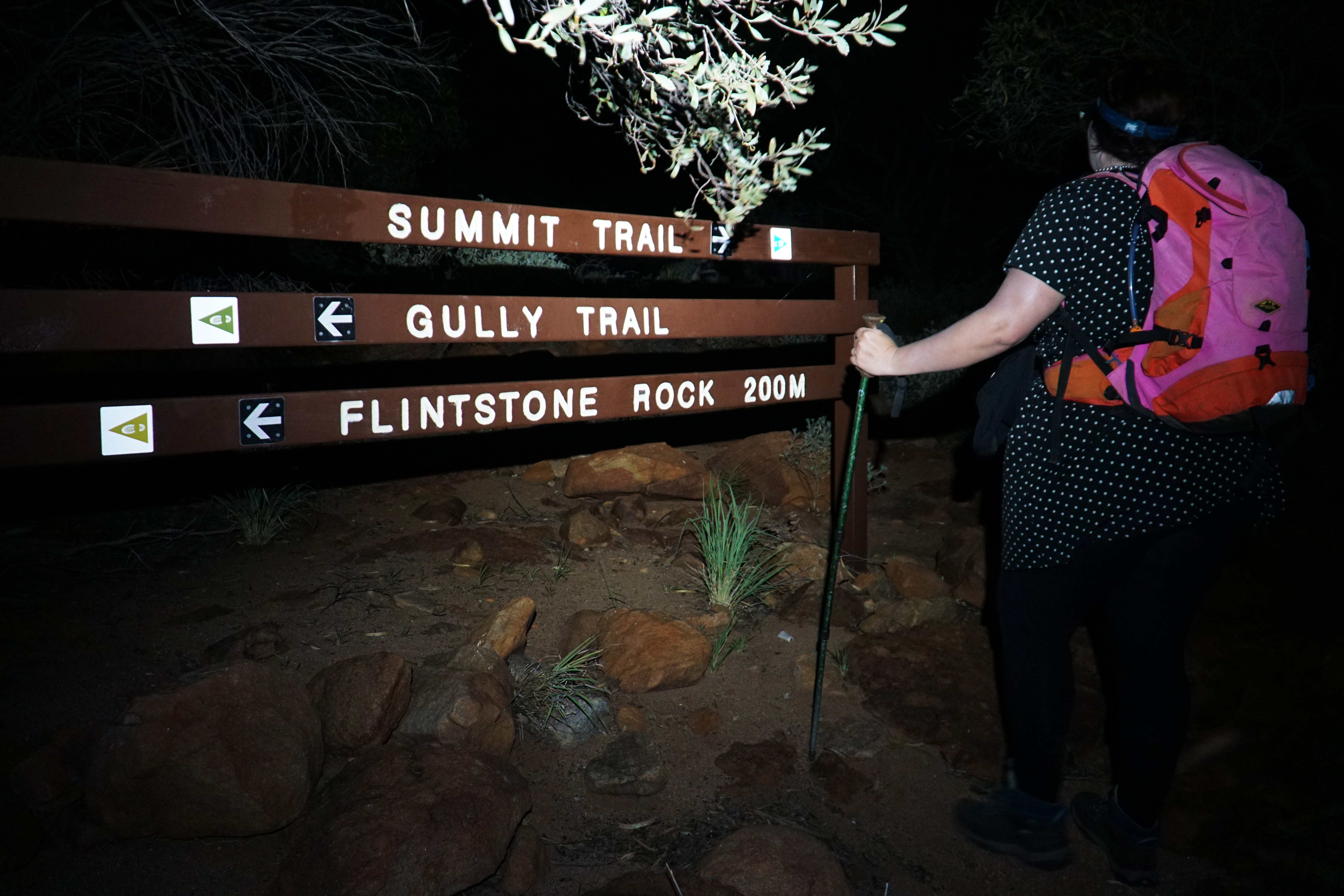
Heading a few hundred metres along the trail, Alissa and I reached the first trail junction. Mt Augustus is unusual in that it offers two routes to the summit - the easier Summit Trail and the extremely rugged Gully Trail . Given that we wanted to get to the summit as quickly as possible, we decided to take the Summit Trail up, and then assess out situation on the way down. For reasons you'll see later, I would definitely recommend taking the Summit Trail as the way up the mountain.
The first 1.5 kilometres of the Summit Trail are relatively gentle and easy-going, though given we were starting before sunrise Alissa and I had to make sure our head torches were at their higher settings to watch our footing. Given the rocky, largely unmodified nature of the surfaces this is important for anyone starting out early, however the reflective nature of the markers do help make navigation relatively straightforward.

Near the car park, Alissa had thought she had seen a frog, however it seems too unlikely given the dry, arid nature of the area that we assumed it must have been a bug given the almost biblical locust plague we had driven through made it seem plausible. Just towards the end of the gentle section, I was stopped in my tracks by the sight of a tiny frog sitting in the middle of the trail, thus proving Alissa's original thought was correct. At this stage we were amazed that a frog could even live out this way, and assumed it must be one of those species that lives burrowed underground during the day. As Dr. Ian Malcolm would say, life finds a way.

The gentle gradient ends as the trail reaches a junction with the Gully Trail. The way the two trails work is that they allow a bit of a choose your own adventure mix and match, and at this point walkers could choose to add an extra level of difficulty to their walk by switching to the Gully Trail, or those who realised their folly taking the hard way up can tap out to take the easier going Summit Trail.
While no scrambling is required along the Summit Trail (apart from a few minor spots ear the summit), the section beyond the junction is definitely a much steeper and more difficult section. Where the first 1.5 kms saw an elevation gain of 110 metres, this section is of the same length but features a 340 metre elevation gain - more than triple the steepness! The markings were also a bit less impressive from this point on, however white paint marks on the rocks did cover some of the shortfall in the sections where signage was more scant.

Along this section, Alissa began to struggle. While my climbing abilities have always been better than Alissa's and she agreed that we have done much more difficult walks elsewhere, the issue was that the medication she had recently started taking had nausea as a fairly common side effect, and all the climbing was really starting to make her feel unwell. For now she decided to press on as best she could, but it did mean our overall progress had slowed significantly and it started making me paranoid that as a result we were going to still be out at the hottest time of the day...

Due to the obvious risk of dehydration and hyperthermia and the recent deaths, it appeared either DBCA or a trail angel had left a small cache of water bottles along this steep section of the trail. Given that people underestimating the amount of water they need to carry is a real problem along arid climate walks, Alissa and I thought this was a really good idea that could very well save the life of someone who blissfully ignored the already significant warnings DBCA put in place at the start of the trail. Even with no Sun in the sky and most of the night having elapsed for temperatures to drop, Alissa and I agreed that it still felt pretty warm and were amazed that people would even consider setting out for this walk at midday in the hotter months.

Continuing along the steep ascent in the darkness meant we really couldn't see very much of the landscape, however there were still some cool features that were obvious landmarks, such as this extremely bent eucalypt that acts as a bit of an arch for hikers to walk through.
With the first rays of sunlight beginning to brighten the sky, the end of the steep climb looked like it was coming into view, however it felt like one of those mountains where the top seems like it is only metres away but every step forward reveals even more climb to come with the end seemingly unreachable. At this point, Alissa was not looking too well and had thrown up along the ascent, and it became obvious to both of us that she was going to feel unwell if she continued walking uphill and that delaying our descent due to a slower pace also had its risks.

We weighed up our risks and options and decided that Alissa would wait here at this spot given it was a relatively shaded spot along the climb, and I would continue alone to the summit. Splitting up and my continuing along solo is obviously a risk, but given my experience, general speed and fitness, our assessment was it should be fine for me to continue onwards to the summit, with a contingency plan for Alissa to come up and look for me if I failed to return by a certain time.
With the rising Sun meaning I could put away my head torch, it was actually not too far from where Alissa and I parted ways to the third junction with the Gully Trail, at which point the two trails become one trail to the summit. Given the relatively short distance, it made me wonder in hindsight if Alissa should have continued onwards for a little bit longer given it was said to be a gentle gradient after the junction and we could then take the Gully Trail all the way down.
While the junction is a clear division point, the reality is that the steep climbing continues on for a few hundred metres more, with some walking along some rocky ridge lines. I chuckled to myself as I imagined Alissa referring to it as walk along a 'pizza crust', a term she came up with for the ridge line walking we did on the Cathedral Range Northern Circuit in Victoria.
The trail does even out as it makes it way across the flats to the summit. The walking here is easy and uncomplicated, and allowed me to cruise along at a decent pace while being able to appreciate the surprisingly vegetated nature of this harsh Outback mountain environment.
Heading across the flats and with the sun continuing to rise, one of the most spectacular moments of the walk was when plains on the other side of the mountain came into view as they were bathed in the vivid glow of sunrise. The photo above does not truly capture the intensity of the colours, the magic of an Outback sunrise really needs to be seen in person to be fully appreciated.
Continuing to head east and with the Sun rising in the sky, the landscape across the mountain was bathed in the glow of golden hour. As a result the fields of flowering spinifex looked extra beautiful, reminding me of similar landscapes Alissa and I have encountered along the Camel Trail in Millstream-Chichester National Park and of course the mountains and plains of the Hamersley Range in Karijini National Park.
Having walked across relatively broad flats, the landscape narrows as the trail skirts the edge of a steep slope leading towards the summit. As a fan of rugged landscapes, I was really enjoying this section of the walk while keeping in mind that it meant the final steep push to the summit was approaching.
Initially following the contours eastwards, the trail takes a sudden sharp turn south as the final 300 metre ascent to the summit begins. This is the only part of the walk that requires some scrambling, and while only mild compared to some of the trickier mountains in Western Australia (Toolbrunup and Talyuberlup in the Stirling Range, Mt Bruce in Karijini), I jettisoned my trekking poles to make this last push a bit easier.
Looking back down across the landscape, the views from the climb were beautiful. It felt completely unreal to see just how much of the mountain is vegetated, and it really looked like the north-eastern slopes were covered in a dense forest (though in reality the trees were much smaller). While not surrounded by the towering mountain ranges like Mt Bruce, there are still a number of smaller hills and mountains that can be seen from the summit which provide visual anchor points in the otherwise flat landscape.
After taking a moment to appreciate the views, I continued on for the last short, sharp push to the summit.
The summit of Mt Augustus is marked by a picnic table and an impressive summit cairn that has actually been cemented together rather than being a giant jumble of rocks as is more common.
A metal box is located on the picnic table, containing a summit logbook for hikers to write in, as well as a couple of spare bottles of water as another emergency cache. The box also contains a note congratulating those who have climbed to the summit. The most interesting information however relates to the cairn which was made by Senior Park Ranger Keith Moon (not the Who drummer) who had to haul the water and cement up the mountain either himself or by talking hikers into helping him. He also brought up the materials for the table and benches which he constructed on site. Moon died in 2006, but his memory lives on through his magnificent cairn.
The view from the summit is quite remarkable, with 360° views of the surrounding landscape. Looking east of the mountain towards the rising Sun, I could make out the Mt Augustus Tourist Park where Alissa and I were been staying.
After taking a moment to take in the views, I began the descent of the mountain. Heading down, the final 300 metre ascent became a fairly steep descent, and I was glad I had good, grippy boots to help with the descent before reuniting with my trekking poles. I was glad when the 300 metres were over and I was back on the 2.7 kms of gentle walking back across the flats.
While more of the trail was bathed in sunlight than it had been on the way up, there were still shaded sections that provided some relief from the slowing increasing heat. One of the fortunate aspects of the trail is that it is mostly on the south-western slope of the mountain, meaning more of it is in shade in the morning - all the more of a reason to do this walk early given by midday the entire walk is largely out in the open.
Back out in the Sun, I was glad to see the view of the surrounding landscape to the south-west of the mountain once again.
I'm definitely more interested in being wowed by grand, sweeping vistas of beauty that having to look for tiny details to appreciate in otherwise unremarkable landscapes - something that I think exasperates my podcasting partner Mark Pybus who loves to say that the devil is in the detail. Being in a rush to get to the summit, I had noticed a precession of caterpillars crossing the trail on my way up, and made a mental note to photograph them on the way down. Thankfully these slow moving creatures hadn't made particularly impressive progress and I was able to get in a quick snap of this fascinating sight on my way out.
With the descent increasing in steepness, I was glad to see the junction with the Gully Trail again as it meant I would soon be reunited with Alissa.
On my way up, I had seen the nearby mountains of Mt Samuel and Mt Phillips on the horizon however without a tripod they were too difficult to photograph in the low light. It was lovely to see them clearly on the way down as they make for a really dramatic scene.
Reunited with Alissa, I was glad to see she was feeling better, with the nausea having passed. Given I'd made good time to the summit and back, our fears about being out longer than we had anticipated were also allayed and we were feeling confident we would get back to the car in less than six hours, and probably closer to five. Alissa said she had really enjoyed the view from where she had stopped as she was able to take in the sunrise across Mts Samuel and Phillips, and said she would actually like to come back another time to go all the way to the summit as she felt that other than the nausea the walk was actually not too difficult and very picturesque.

While one of the reasons I don't like walking a trail in darkness is because I genuinely believe a trail should be as much about the journey as the destination, and I like seeing the landscape properly along the way. However, given it is (in part) a there and back walk, it was nice to be surprised by what the trail looked like in the daytime, with sections like the tree arch serving as excellent points of comparison.

While we were able to make out the general shape of the gully along the Gully Trail on the way up, in the daylight we could really see the gully clearly. It definitely looked like the rough and tough Class 5 scramble that it is rated as being, and while it would have been nice to have done this first bit of the trail I can imagine it would have been a lot more slow going than the Summit Trial descent. Additionally, going up this way in darkness would probably be extremely dangerous given the scrambling. I would not recommend using it for the ascent unless it is in the cooler months when the whole thing can be done in daylight hours.
Reaching the second junction with the Gully Trail, Alissa and I were looking like we would get back to the car in less than five hours and Alissa offered that we could take the Gully Trail back down if I wanted. Seizing the opportunity, I immediately said yes as we took the turn right to join this rugged alternative back to the car park.
Right near the junction, I was surprised to see water pooled in the shade below a large rocky wall. Stain marks on the rock indicated that this area can get quite full after a heavy downpour, with the rains from a few months ago obviously replenishing the ephemeral pools. The appearance of the frog suddenly made sense, though it was still incredible that such a small amount of water could provide enough of an oasis for frogs to breed.
Continuing down, the Gully Trail is definitely a lot rockier and more slow going than the Summit Trail. Alissa and I had to constantly clamber along the rocks as we followed the markers down the completely unmodified natural landscape.
Something Alissa and I had noticed on the way down the Summit Trail is the number of quartzite rocks that were embedded in the sedimentary rock that Mt Augustus is largely made out of. While quite fascinating along the descent, these embedded quartzite features were even more impressive in the gully. The water had obviously washed away the layers of sedimentary rock, revealing tessellated mosaic-like patterns in the cracked quartzite that really look like the floor of an old Roman ruin.
Even though it was still fairly early in the morning, with the somewhat exposed nature of the gully meant the rock was already heating up. While the radiant heat was not enough to cause us any real concern, it certainly wasn't feeling very comfortable and the slower pace of the scrambling meant we were going to have to experience the higher temperatures for a lot longer than if we had just taken the Summit Trail.
Continuing down the gully, the gorge walls narrow through a section that obviously fills out into a pool after heavy rains given the obvious water stain lines, and it made Alissa and I wonder how often it actually fills up and for how long the higher water levels are maintained.
The constriction through here must force the water through at this point, as the rock was polished smooth in quite a few sections. Alissa enjoyed the fun of using the dry, ephemeral waterfall as a slide to make her way down one of the gully's rocky shelves.
Entering a shady, tree-lined section of the gully, Alissa and I took a moment to enjoy the luxury of cooling shade and the overall idyllic nature of a spot that have been even more spectacular when the water is flowing.
Through this section, the gorge walls grew higher and more impressive, reminding us of the fun adventure we had travelling between Four Ways and the Z-Bend in Kalbarri's River Gorge - albeit without the swimming that had been required along that walk.
As we entered this deeper section of the gully, Alissa and I began to encounter a number of small puddles of fairly smelly stagnant water along the way, some of which we had to jump across to avoid getting our feet wet. Rounding a corner, Alissa and I were completely amazed by sight of a small shaded oasis along the trail, with a more substantial pool and a great density of shade-providing Eucalypts growing along it's banks. While the somewhat algal nature of the water and its less that pleasant odour did not make us want to go for a dip, the water would at least provide some emergency relief for hikers if they were really feeling dangerously overheated.

Continuing along the bend in the creek, the two of us were surprised to find that the oasis was just the beginning of a long, continuous series of pools very gently flowing into each other. Given that the area had experienced higher than usual rainfall over Summer and early Autumn, it had me wondering how permanent these pools were and whether this level of water was normal for the trail at this time of year. Whatever the case, the frogs were definitely loving life at the moment and the number of frogs we has seen earlier along the Summit Trail made a lot more sense given this was substantially more water than a couple of stagnant pools.

We had seen a big grove of trees near the start, and when we saw the pools we assumed that we must be coming close to the end. As we continued downstream we were surprised to see the return of rugged and largely treeless gully, this time with water slowly flowing down. The water meant Alissa and I had to clamber up the sides to the right in the image above, and there were some other awkward moments like climbing to the side of what would have been a fairly impressive waterfall and swimming hole after rains, but at the time of our visit was a slow trickle into a fairly sulphurous-smelling pool of black coloured water.

The gully opens up to a wide amphitheatre-like space, and this really does mark the home stretch of the Gully Trail, with the grove of trees in the background being the ones Alissa and I had seen at the start of the trail. There are apparently some petroglyphs that can be seen along the trail here, however by the time Alissa and I realised we'd passed it, we were so tired of the heat that we decided not to double back and weren't sure about the ethic of sharing the images even if I had photographed them.
Leaving the gully behind, Alissa and I bade farewell to the little frogs as we finally reentered the eucalypt grove.
Just over five hours after passing the junction sign on the way up, Alissa and I were finally back at the same sign having completed the Gully Trail and thus ending the loop. Alissa's expression is a good illustration of how we were feeling, the heat had definitely sapped our energy and enthusiasm, and we were looking forward to being rid of it.
From the junction it is only a short walk to the car and the end of the trail, at which point the elation of completing the trail finally set in.
After completing the trail, Alissa and I were meant to go do another walk in the afternoon but the combination of the heat and lack of sleep meant we were pretty shattered when we got back to the Tourist Park. In spite of doing my best to hydrate well I had a splitting headache by the early afternoon and ended up having a nap before waking up in the late afternoon to go out and see Cattle Pool - a permanent waterhole along the Lyons River.
In the late afternoon Sun, the white gum-lined pool was a truly idyllic spot, and it reminded me a bit of Millstream-Chichester National Park. This definitely was a lot more inviting than the water along the Gully Trail, and if Alissa and I were more inclined to go swimming at the drop of a hat would have definitely partaken in this lovely oasis in the middle of the arid Outback.
Driving away from Cattle Pool, Alissa and I realised the road was a perfect vantage point for a panoramic view of Mt Augustus in all its grandeur.
Finally, Alissa and I drove to Emu Hill where the Shire of Upper Gascoyne has built a well placed lookout to watch the sun setting on Mt Augustus. It's a magical view, and one that Alissa and I took our time to savour.
Mt Augustus asks a lot of hikers; it requires a long drive on unsealed roads in a harsh and inhospitable part of the arid Australian Outback, and its potentially deadly heat dictates that hikers need to make an early start if they want to complete the walk in the cooler hours. Thankfully, Mt Augustus is a thoroughly excellent and rewarding mountain walk, made all the better thanks to the fact it offers both the Summit and Gully Trails as route options up and down the mountain. While there are some steep sections, the Summit Trail is moderately easy compared to other mountain walks we've done, being easier than Mt Bruce in Karijini and being more engaging than the endless steps of the frankly overrated Bluff Knoll (which incidentally is not as tall as Mt Augustus).
The fact it also offers the Gully Trail and its spectacular oasis really takes it to the next level, making it have less of a destination-oriented feel than most mountain walks and instead feeling like a more complete trail experience. Alissa is not a big fan of mountain walks, but even she agreed it was easier and more enjoyable than many other mountains and the fact she didn't get to finish made her want to come back another time. Given Alissa has skipped going all the way to the summit on a few walks we've done, that says a lot.
Now about timing. While I do think visiting in April probably meant the gully's pools were fuller than usual, it does mean you need to be committed. To be blunt, if you're not prepared to suck it up and get up stupidly early, I seriously advise not visiting Mt Augustus in the hotter months and instead leaving it for the far milder conditions in July. Even then, I would still consider getting up at sunrise as it can still get fairly warm out there.
Additionally, if you're going in the hotter months, be prepared for the fact you will need to stay overnight so you can start early. Due to the heat of the day, you might also find you can't fit in another walk in the afternoon, so if you plan on visiting more of the sites it might be worth allowing an extra day to go and check out the Pound and Kotka Gorge which look pretty interesting. As we missed out on seeing more, Alissa and I have said we definitely would like to come back and visit Mt Augustus again some time in the future. Given the difficulty of even getting there, I don't think we can give it a more ringing endorsement.


0 comments:
Post a Comment