

A short but adventurous trail, the Z Bend River Trail takes walkers down into the Z Bend of the Murchison River Gorge. After viewing the sheer cliffs of the Z Bend from a lookout, the trail descends through a side gorge, following a route over boulders, ladder climbs and narrow chasms to reach the river itself. With its beautifully rugged terrain, the Z Bend River Trail is a great primer for the multi-day River Gorge Hike.
Distance: 2.6 km (return)
Gradient: Fairly even for the first 500 metres, then a steep descent down into the gorge. Some steep ladder climbs are required.
Quality of Path: Relatively clear and straightforward, though much of the trail is along unmodified rocky surfaces. Some scrambling may be required.
Quality of Signage: Good and informative trailhead, with waypoint signs along the way and some information panels at key points.
Experience Required: Previous Bushwalking Experience Recommended.
Time: 1.5 Hours
Steps: Several formal and informal steps. Several ladder climbs.
Best Time to Visit: Winter-Spring. Best to avoid during the wet autumn due to high river levels and during the dangerously hot Summer months.
Entry Fee: Yes. National Park Fees apply
Entry Fee: Yes. National Park Fees apply
Getting There: Access to the the trail is via Murchison Gorge access road off Kalbarri-Ajana Rd.

After completing the Loop Walk in Kalbarri National Park early on the Saturday morning, the temperatures rose to the uncomfortably high 38°C that had been forecast. With such warm weather, Alissa and I spent the rest of the day literally chilling out in the air conditioned comfort of our hotel room and in the hotel's pool. Although Sunday was not forecast to get quite as hot (it was 'merely' 34°C), Alissa and I nevertheless woke up early again on Sunday morning so we could head back out to the Murchison River Gorge and complete the Z Bend River Trail in the cooler hours. At 2.6 kilometres return, its a shorter trail than Alissa and I generally walk, however reading that it was more challenging and rugged than the Loop Walk definitely piqued our interest.

The trail starts at the Z Bend Car Park, a right turn from the T Junction along the main gorge road. All walks from the car park initially follow the same well formed and relatively flat path, with the longer Four Ways Trail branching off from the main track early on. About 500 metres in, there is a fork in the trail, with the path to the left taking walkers to the Z Bend Lookout, while the trail to the right leads walkers down to the river itself. Arriving at sunrise, the sun was in a bad position to take photos from the Z Bend Lookout, so we continued on down to the River Trail.

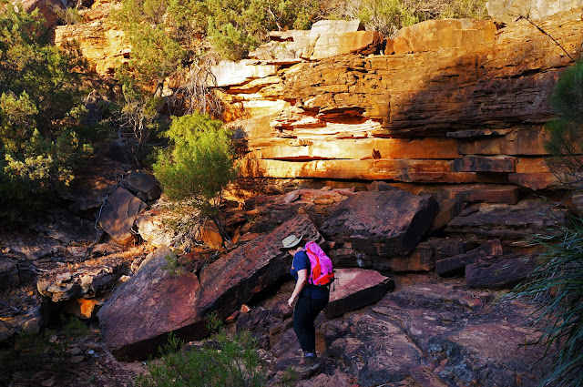
Almost immediately, the trail becomes a lot more rugged and steep as it follows a route through a side gorge down to the river.

Like the Loop Walk, the Z Bend River Trail runs along fairly unmodified surfaces, however the sedimentary layers have been worn away in a manner than creates natural steps; experienced bushwalkers should have no difficulty negotiating this terrain. The route is fairly obvious too given that it follows the most logical and least challenging course to the bottom. If in doubt, the directional signage is clear and easy to follow as well.

After the first descent, Alissa and I were immediately impressed by the sheer gorge walls of Tumblagooda Sandstone that we were walking alongside. Small hand holds in the rock made the wall look like the kind of place rock climbers would enjoy, however these small walls would be completely dwarfed further along the trail, and there are apparently really impressive walls in more remote sections of the gorge.
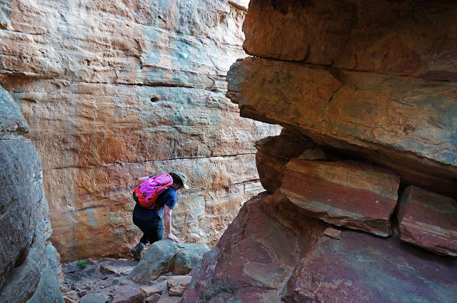
After clearing the narrow passageway along the sandstone walls, the track runs through an open area filled with huge rock slabs that had obviously fallen over centuries of erosion. After passing these slabs, the track enters an open area with a wide ledge.

From this wide ledge, walkers will encounter the first of the ladder climbs along the trail. The condition of the ladders seemed to indicate that they are a relatively recent addition to the walk, and I can imagine that it would have required a bit of a scramble to get down from this ledge in the past. A scramble is always a bit of fun, however the ladders didn't have any serious impact on the enjoyment of the walk and probably make the walk a lot safer.


Heading further into the gorge, we came across many of White River Gums common to the Murchison River Gorge. These trees seem to grow in some of the weirdest places and in the most twisted shapes, with quite a few of them growing almost horizontally from cracks and fissures in the sandstone.

A sign indicates that there are surveillance cameras in operation nearby. These cameras are likely here due to the Black-Flanked Rock Wallabies that live in the gorges. Once thought to have been extinct in the Kalbarri area for over 20 years due to predation from foxes and overgrazing from feral goats, rock climbers discovered a couple of wallabies and their joey living near the Z Bend in 2015, and a lot of work has been done to help reestablish a population of these endangered animals in the park.

Beyond the ladder climb, walkers will need to clamber down a few boulder steps to reach a relatively open area from which to admire the sandstone walls and the vegetation growing in the gorge system.

The time in the open area is fairly brief however, with the trail soon descending through a narrow chasm.

'You will like this!' Alissa said, knowing that I love this kind of adventurous terrain. Fallen rocks create a natural set of steps down into the the first part of the chasm, and walkers will need to use their hands to help steady themselves through the descent.

Beyond the descent, the walking is relatively even, however a second rocky descent needs to be negotiated before reaching what looks from afar like a dead end.
The dead end is actual just a sharp 90° turn left, followed by an immediate 90° turn right along the sheer sandstone cliffs.

Immediately after the turn, walkers are required to negotiate their way through more boulders before reaching the second of the trail's ladder climbs.

This is a fairly elaborate setup, with the first ladder climbing up a massive, tilted boulder before descending on the other side.

Before the ladders, I imagine that it would have been easier to have continued straight down through the narrowing chasm rather than climbing over the rock, however the ladder climb allows for a more adventurous route with a high vantage point from which to view the trail below.

Looking back, you can see how the rugged route is made from a jumble of fallen boulders that have locked into place under their own weight. The large tilted boulder in the middle is the one between the two ladder climbs.

Beyond the ladder climbs, the walking remains rugged but much more open, with enough space for many large White River Gums to be thriving.

At this point, we began to here the sound of bees everywhere, and we realised that the largest tree in the area was home to a bee hive! This is something we had not expected at all, and we tried to make our way past the trees as fast as we could. As Alissa and I are not allergic to bees, we were happy to keep going, however I would advise walkers with bee allergies to seriously reconsider going any further due to the high risk of bee sting.

Beyond the tree, the trail descends down one final rocky scramble.

From here on, the track becomes fairly easy going as it reaches the river. The easiness may have given Alissa a false sense of security however; seconds after this photo was taken, she put her hand down on the rocks to the left and placed it right on a bee which promptly stung her! We always carry a medikit with us for situations like this, and Alissa immediately took an antihistamine tablet. Although her hand initially swelled in the area that was stung, she recovered remarkably quickly and by the time we had finished the walk you would have barely known she had been stung.


Beyond another bee-infested White Gum, the trail reaches its official end, however with the river just a few metres in front of us, we decided to continue down to the water's edge. It is called the River Trail after all, and it seemed a bit anti-climactic to be so close to the river without actually going all the way.

Continuing down to the river was entirely worthwhile as the view downstream of the Murchison Gorge is spectacular, with seriously huge walls of Tumblagooda Sandstone towering in the background. The Z Bend is the halfway point of the River Gorge Hike - a four day hike that can be completed from the Ross Graham Lookout to Natures' Window. This view serves as a great primer for those interested in undertaking this wild route. As the River Gorge Hike requires overnight camping in the gorges and carrying in all your water with you, walkers are required to register and seek permission from DPaW before setting out - do not attempt this walk without doing so first!

With the trail completed, walkers retrace their steps back up out of the gorge.

Being continually uphill, this has its own set of challenges and is thus not a simple repeat of the walk down.


On the way back up, Alissa I took to short side trip to the Z Bend Lookout. The photo above shows the section where the Z Bend River Trails enters the Murchison River.

With the sun still in a poor position for a clear photo downstream from the lookout, I noticed that there were a series of steps leading to a platform between a chasm nearby. With the rock formation to the left blocking the Sun, the photo above shows the view downstream, and its pretty clear that there are some fairly sheer cliffs along the river as it turn around the Z Bend towards the junction at Four Ways. After taking our photos, Alissa and I returned to the car with our mission to walk the Loop Walk and Z Bend River Trail over the weekend completed.
Alissa and I really enjoyed the Z Bend River Trail, and most experienced hikers who love rock hopping and walking through rugged terrain will love what this trail has to offer. The only problem with it is that it very short, and compared to the logical loop of the Loop Walk, the shortness makes it feel like a 'lesser' walk even though the scenery is arguably more epic and beautiful in the Z Bend.
Considering that the Four Ways Trail also departs from the Z Bend car park, I can imagine a pretty amazing, rugged walk could be constructed by linking the two walks via the Murchison Gorge. Such a walk could be WA's answer to the Blue Mountains' Grand Canyon Walk (one of my all-time favourites), however if this was not feasible then it would still be nice to see the Z Bend River Trail extended further up the river as suggested in DPaW's Kalbarri National Park Management Plan.
Although I feel the River Trail could be an even greater trail with an extension, what is there currently is nevertheless impressive. While I would not recommend this to casual tourists, experienced walkers should definitely make the Z Bend River Trail a priority when visiting Kalbarri National Park. You will not regret it.

After completing the Loop Walk in Kalbarri National Park early on the Saturday morning, the temperatures rose to the uncomfortably high 38°C that had been forecast. With such warm weather, Alissa and I spent the rest of the day literally chilling out in the air conditioned comfort of our hotel room and in the hotel's pool. Although Sunday was not forecast to get quite as hot (it was 'merely' 34°C), Alissa and I nevertheless woke up early again on Sunday morning so we could head back out to the Murchison River Gorge and complete the Z Bend River Trail in the cooler hours. At 2.6 kilometres return, its a shorter trail than Alissa and I generally walk, however reading that it was more challenging and rugged than the Loop Walk definitely piqued our interest.

The trail starts at the Z Bend Car Park, a right turn from the T Junction along the main gorge road. All walks from the car park initially follow the same well formed and relatively flat path, with the longer Four Ways Trail branching off from the main track early on. About 500 metres in, there is a fork in the trail, with the path to the left taking walkers to the Z Bend Lookout, while the trail to the right leads walkers down to the river itself. Arriving at sunrise, the sun was in a bad position to take photos from the Z Bend Lookout, so we continued on down to the River Trail.

Almost immediately, the trail becomes a lot more rugged and steep as it follows a route through a side gorge down to the river.

Like the Loop Walk, the Z Bend River Trail runs along fairly unmodified surfaces, however the sedimentary layers have been worn away in a manner than creates natural steps; experienced bushwalkers should have no difficulty negotiating this terrain. The route is fairly obvious too given that it follows the most logical and least challenging course to the bottom. If in doubt, the directional signage is clear and easy to follow as well.

After the first descent, Alissa and I were immediately impressed by the sheer gorge walls of Tumblagooda Sandstone that we were walking alongside. Small hand holds in the rock made the wall look like the kind of place rock climbers would enjoy, however these small walls would be completely dwarfed further along the trail, and there are apparently really impressive walls in more remote sections of the gorge.

After clearing the narrow passageway along the sandstone walls, the track runs through an open area filled with huge rock slabs that had obviously fallen over centuries of erosion. After passing these slabs, the track enters an open area with a wide ledge.

From this wide ledge, walkers will encounter the first of the ladder climbs along the trail. The condition of the ladders seemed to indicate that they are a relatively recent addition to the walk, and I can imagine that it would have required a bit of a scramble to get down from this ledge in the past. A scramble is always a bit of fun, however the ladders didn't have any serious impact on the enjoyment of the walk and probably make the walk a lot safer.


Heading further into the gorge, we came across many of White River Gums common to the Murchison River Gorge. These trees seem to grow in some of the weirdest places and in the most twisted shapes, with quite a few of them growing almost horizontally from cracks and fissures in the sandstone.

A sign indicates that there are surveillance cameras in operation nearby. These cameras are likely here due to the Black-Flanked Rock Wallabies that live in the gorges. Once thought to have been extinct in the Kalbarri area for over 20 years due to predation from foxes and overgrazing from feral goats, rock climbers discovered a couple of wallabies and their joey living near the Z Bend in 2015, and a lot of work has been done to help reestablish a population of these endangered animals in the park.

Beyond the ladder climb, walkers will need to clamber down a few boulder steps to reach a relatively open area from which to admire the sandstone walls and the vegetation growing in the gorge system.

The time in the open area is fairly brief however, with the trail soon descending through a narrow chasm.

'You will like this!' Alissa said, knowing that I love this kind of adventurous terrain. Fallen rocks create a natural set of steps down into the the first part of the chasm, and walkers will need to use their hands to help steady themselves through the descent.

Beyond the descent, the walking is relatively even, however a second rocky descent needs to be negotiated before reaching what looks from afar like a dead end.

The dead end is actual just a sharp 90° turn left, followed by an immediate 90° turn right along the sheer sandstone cliffs.

Immediately after the turn, walkers are required to negotiate their way through more boulders before reaching the second of the trail's ladder climbs.

This is a fairly elaborate setup, with the first ladder climbing up a massive, tilted boulder before descending on the other side.

Before the ladders, I imagine that it would have been easier to have continued straight down through the narrowing chasm rather than climbing over the rock, however the ladder climb allows for a more adventurous route with a high vantage point from which to view the trail below.

Looking back, you can see how the rugged route is made from a jumble of fallen boulders that have locked into place under their own weight. The large tilted boulder in the middle is the one between the two ladder climbs.

At this point, we began to here the sound of bees everywhere, and we realised that the largest tree in the area was home to a bee hive! This is something we had not expected at all, and we tried to make our way past the trees as fast as we could. As Alissa and I are not allergic to bees, we were happy to keep going, however I would advise walkers with bee allergies to seriously reconsider going any further due to the high risk of bee sting.

Beyond the tree, the trail descends down one final rocky scramble.

From here on, the track becomes fairly easy going as it reaches the river. The easiness may have given Alissa a false sense of security however; seconds after this photo was taken, she put her hand down on the rocks to the left and placed it right on a bee which promptly stung her! We always carry a medikit with us for situations like this, and Alissa immediately took an antihistamine tablet. Although her hand initially swelled in the area that was stung, she recovered remarkably quickly and by the time we had finished the walk you would have barely known she had been stung.


Beyond another bee-infested White Gum, the trail reaches its official end, however with the river just a few metres in front of us, we decided to continue down to the water's edge. It is called the River Trail after all, and it seemed a bit anti-climactic to be so close to the river without actually going all the way.

Continuing down to the river was entirely worthwhile as the view downstream of the Murchison Gorge is spectacular, with seriously huge walls of Tumblagooda Sandstone towering in the background. The Z Bend is the halfway point of the River Gorge Hike - a four day hike that can be completed from the Ross Graham Lookout to Natures' Window. This view serves as a great primer for those interested in undertaking this wild route. As the River Gorge Hike requires overnight camping in the gorges and carrying in all your water with you, walkers are required to register and seek permission from DPaW before setting out - do not attempt this walk without doing so first!

With the trail completed, walkers retrace their steps back up out of the gorge.

Being continually uphill, this has its own set of challenges and is thus not a simple repeat of the walk down.


On the way back up, Alissa I took to short side trip to the Z Bend Lookout. The photo above shows the section where the Z Bend River Trails enters the Murchison River.

With the sun still in a poor position for a clear photo downstream from the lookout, I noticed that there were a series of steps leading to a platform between a chasm nearby. With the rock formation to the left blocking the Sun, the photo above shows the view downstream, and its pretty clear that there are some fairly sheer cliffs along the river as it turn around the Z Bend towards the junction at Four Ways. After taking our photos, Alissa and I returned to the car with our mission to walk the Loop Walk and Z Bend River Trail over the weekend completed.
Alissa and I really enjoyed the Z Bend River Trail, and most experienced hikers who love rock hopping and walking through rugged terrain will love what this trail has to offer. The only problem with it is that it very short, and compared to the logical loop of the Loop Walk, the shortness makes it feel like a 'lesser' walk even though the scenery is arguably more epic and beautiful in the Z Bend.
Considering that the Four Ways Trail also departs from the Z Bend car park, I can imagine a pretty amazing, rugged walk could be constructed by linking the two walks via the Murchison Gorge. Such a walk could be WA's answer to the Blue Mountains' Grand Canyon Walk (one of my all-time favourites), however if this was not feasible then it would still be nice to see the Z Bend River Trail extended further up the river as suggested in DPaW's Kalbarri National Park Management Plan.
Although I feel the River Trail could be an even greater trail with an extension, what is there currently is nevertheless impressive. While I would not recommend this to casual tourists, experienced walkers should definitely make the Z Bend River Trail a priority when visiting Kalbarri National Park. You will not regret it.


I like this post,And I guess that they having fun to read this post,they shall take a good site to make a information,thanks for sharing it to me. Black River Gorges National Park
ReplyDeleteWow, amazing blog layout! How long have you been blogging for? you made blogging look easy. The overall look of your website is great, as well as the content! Alessandro Bazzoni
ReplyDelete