
A one way day walk in Fitzgerald River National Park on the Hakea Trail, this walk explores the eastern end of this Top Trail. Starting at Cave Point, the trail features some excellent beach walking and sections through biodiverse heath at the clifftop. Descending Edwards Point Steps, the zawn and rocky beach before Hamersley Beach represent the best kilometre of the entire Hakea Trail
Distance: 11 km (one way)
Gradient: A mix of moderately steep descents and ascents, with more gentle sections and some flat beach walking
Quality of Path: Largely clear and well maintained; a mix of unmodified beach walking and purpose built walk trails. Some minor vehicle track walking near Edwards Point
Quality of Signage: Largely well signed, with clear markers and trailheads at major points with kilometre information
Experience Required: Previous Bushwalking Experience Required
Time: 3 Hours
Steps: Many formal and informal steps along the track, particularly along the ascent and descents from the beaches and at Edwards Point Steps
Best Time to Visit: Spring, but doable from Autumn through to Spring
Entry Fee: Yes. National Park fees apply
Getting There: This day walk on the trail starts at Cave Point and ends the Hamersley Inlet car park car park. From Hopetoun, take Hamersley Dr into the national park and follow the road into the park, taking the turn off left to Cave Point 8.3 kilometres after the entry station and continue to trailhead located right at the end of the road. To get to Hamersley Inlet continue on Hamersley Dr all the way to the end of the road. The major trailhead is located at the endEntry Fee: Yes. National Park fees apply

After spending the morning walking back from our overnight stay at Whalebone Creek, Alissa and I headed east through Fitzgerald River National Park to Cave Point. With the overnight section of the hike completed, Alissa agreed to by my support driver for the day as I set off to complete the rest of the Hakea Trail as a day walk.

From the eastern trailhead, the Hakea Trail immediately begins a descent down to the ironically named West Beach since it is the easternmost beach of the walk and within the eastern part of Fitzgerald River National Park!

West Beach is typical of beaches in the park - fine white sand, crystal clear waters and the typical shard-like schist formations that are a signature of the Fitzgerald Coast.
Leaving the main beach behind, the trail heads along the top of some rocky headland as it skirts the edge of the park's biodiverse heath.


Heading down to another shorter stretch of beach walking, the trail features a memorable section that passes through a narrow chasm before continuing along an area surrounded by more large boulders.

After the boulders, the trail, leave the beach for the final time and heads inland through the heath. This route seems to have been chosen due to the high coastal ridge beyond as it is a nice gentle climb to the cliff top.

The heath here is mostly of the low, natural hedge variety, and does not obscure the views. While more pleasant that spectacular at the time that I walked it, this is the sort of area that would be bursting with colour in the springtime due to the wildflower blooms Fitzgerald River is famous for.

Nearer to the top of the cliffs and in a sheltered section of the coast, the trail enters a stretch of mallet woodlands. With trees being a rarity along the walk, these pockets of shade are a welcome change of pace from the more open terrain that typifies this trail.

Reaching the top of the cliffs, the rocky terrain signalled a change of vegetation type with numerous banksia species and hakeas of royal and non-royal lineages on either side of the trail. This was a classic example of another section of the trail that was good but not spectacular in the autumn, but would be a trail highlight in spring as the wildflowers would add a whole lot of interest. There are signs in the area identifying that this has been declared a rare plant location, which would make it a particularly special botanical treat.

At the top of the cliffs, a lookout provides views back down to West Beach and Cave Point. From the lookout point you can see how continuing along the coast instead of heading inland may have provided some interesting walking, but would have resulted in a steeper climb to the headlands.

From the lookout, the trail continues westward along the coastal ridge. Initially, the trail remains close to the edge with good views down to the waves crashing into the rocky headlands below.

The trail heads inland away from the edge of the coastal ridge with views towards low hills. This was probably the low point of this day walk on the Hakea Trail as the scenery became fairly repetitive without the wildflowers. As I had noted with the return journey to Quoin Head, the Hakea Trail is quite a seasonally dependent trail to be at its best, and it is a bit like a major part of the park's magic is missing when walked in seasons other than Spring.

While bridge infrastructure is a lot less prominent between Cave Point and Hamersley Inlet as it is between Whalebone Creek and Quion Head, it was interesting to see an intact bit of boardwalk bridging an area where water probably flows during the winter. These would have been all along the western section of the trail had they not been destroyed by 4WDs which were not really meant to be there, however I again questioned why this was here in the first place. The only bit of conjecture I've heard that makes sense is that this is a measure to minimise the spread of Dieback, but then it begs the question why the bridges have not been reconstructed where they have been destroyed currently.

After the fairly samey scenery inland, it was a welcome change of pace when the track returned to follow the coastline as it approaches Edwards Point.

Another lookout point is located near Edwards Point and refers to the area as 'Nature's Rockery'. As with similar well constructed lookouts on the Mamang Trail, I was surprised to find that the information panels were still blank. Considering these trails are at least 5 years old at the time of writing, it is a real shame that these finishing touches are still not completed. One hopes that someone will get out there and install the information panels and finally complete these missing details.

Beyond Nature's Rockery, the Hakea Trail joins onto an old vehicle track. The track is less distinctly a vehicle track than that long boring stretch between Whalebone Creek to Quoin Head, and has obviously not been used quite as recently be 4WD. Seeing it gave me some comfort that maybe the Quoin Head vehicle track will slowly go back into nature, however it had me wondering if there would be a way to encourage people to only walk on one side and allow the other side to regrow and thus have it become a single file track.

The trail heads right along the edge of the cliffs and provides some really spectacular views down to Edwards Point, and it had me excited as I knew the famous zawn and the Edwards Point Steps were not far away.

Before reaching the steps, the trail heads through another section of mallet woodlands. This was a longer and more sustained section than the previous stretch, and I thought the area was really pretty. The golden and green colour of the trees made for a stunning sight, and it reminded me of how much I love the unique and uncommon Eucalypyts found in the Golden Outback region.

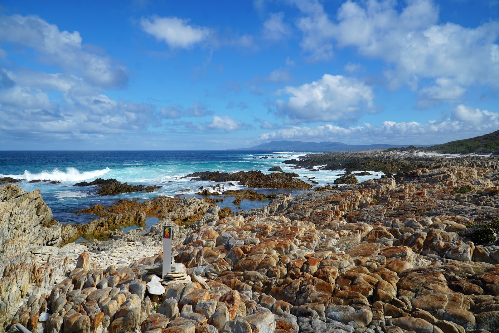
Popping out of the woodlands, the view of the coastline below was extraordinary. While the jagged shards formations along the coast are an iconic but fairly common sight in Fitzgerald River National Park, what greeted me was the most sustained and massive of these jagged formations.

Descending the Edwards Point stairs and glad to be going down, I entered what I would consider the best kilometre of the entire Hakea Trail.
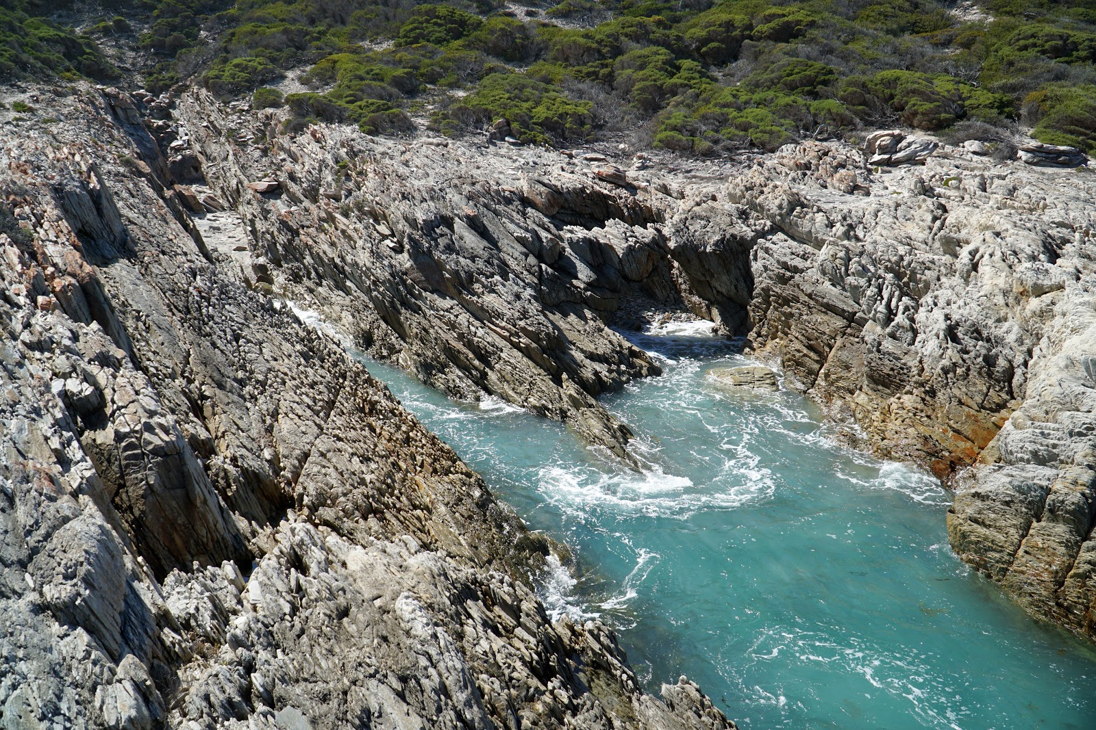
At the bottom of the steps, a short side trip leads to the zawn. The word zawn comes from the Cornish word 'sawan' which means chasm, and the word is fairly apt.

At the zawn the water surges up into the chasm in the rock before flowing out again, continually carving the zawn. This is a spectacular thing to watch in action, and I recommend hikers stop and take their time to enjoy the show of nature in action.

After enjoying the zawn, I continued along the rocky beach. I knew from the earlier view that this was going to be epic, but actually being amongst it I was amazed by just how incredible it was. While I'd been critical of the walk from Whalebone Creek to Quoin Head, this was certainly world class coastal scenery that has to be seen to be believed.

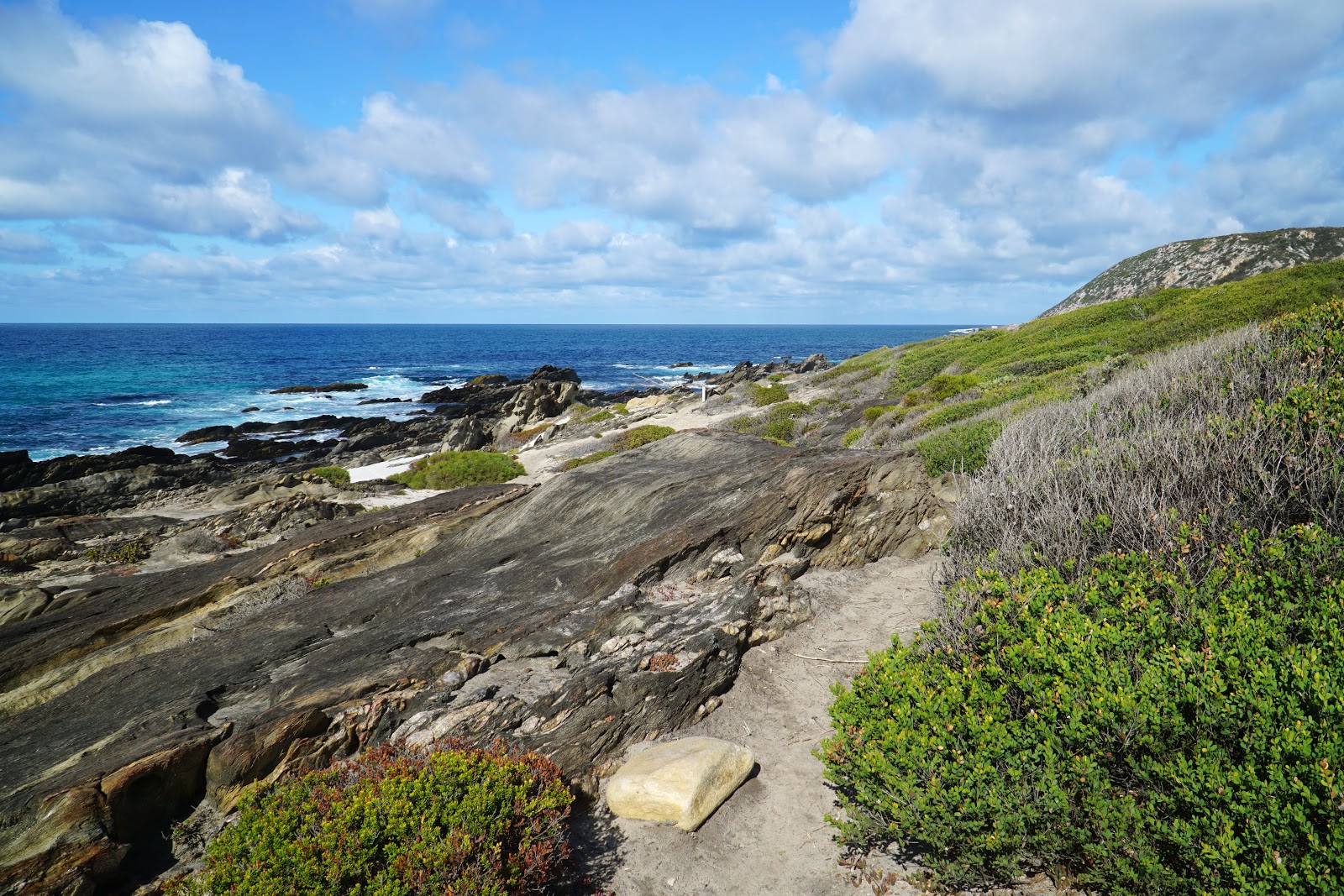
Heading over the weathered rocks, the trail continues behind a low 'valley' between large rocky outcrops on either side before a brief scramble on top.

The rocky beach walking continues for less than a kilometre, however it felt like it stretched out as far as the eye could see. I slowed down to a snail's pace through this section as I was just in awe of how spectacular the coastline was here. It certainly made some of the less thrilling sections worth the effort.

While it was a long stretch of the walk, the cool thing about this beach was the nuances between sections. Near the beginning, the waves were intense and wild, while near the western end the waves were breaking further out and creating gentle pools.

Reaching the end of the beach, I thought I would be saying goodbye to the spiky formations.

I was delighted then when I rounded the corner of the headlands to enter a second stretch of spiky shard beach.

All good things do come to an end however, and I finally exited the second beach as I entered the headland that separates the spiky shard beach from the long beach walk to Hamersley Inlet.

One of the major markers with kilometre information is located along the headland and indicated that I had 2.3 kilometres of beach walking along Hamersley Beach ahead of me. This is not too bad compared to, say, Mazzoletti Beach's 7 kilometres, but it was also disheartening to see that it was 4.1 kilometres to the car park at Hamersley Inlet via the linking trail. That's almost doubling the length of the walk ahead, and would mean walking the linking trail for the third time.


Thankfully, Hamersley Beach was relatively firm under foot and I was able to motor along at a fairly reasonable pace after my slowing going at the shards beach. The walking here reminded me a bit of my beloved Fitzgerald Beach on the Mamang Trail, albeit Hamersley Beach was a lot longer.

Being mostly sand, sporadic rocky outcrops along the beach served as points of interest. This reminded me a bit of the Boranup or Deepdene Beach on the Cape to Cape Track.

Near the start of a rocky shelf, a wooden marker somewhat ambiguously lies at the edge of a massive dune system and the beach, and it is unclear which is the right way to go. While you can go through the dunes if you have an interest in masochism, the easiest and correct route is to keep following the beach.

The rocky shelf really brought back memories of the Cape to Cape Track, and was very Deepdene-like in a lot of ways. It also reminded me of the Rottnest Island's Karlinyah Bidi and the Three Bays Walkway at Green Head.

After passing some four wheel drives and being a bit sick of beach walking, I reached the mouth of the Hamersley Inlet, happy to be nearly finished.

Following the linking trail, it was only 1.8 kilometres (some of which felt longer) before I was at the car park having finally completed the entire Hakea Trail.

The Hakea Trail from Cave Point to Hamersley Inet was a really good day walk. While it may not have had any one major feature as impressive as Quoin Head, it more than made up for it with a kilometre of truly great, world class walking from the start of Edwards Point Steps to the start of Hamersley Beach. Additionally, the less exciting sections were no where near as egregious as the return vehicle track walking from Whalebone Creek to Quoin Head, meaning the overall quality of these 11 kilometres was higher than the 12 kilometres return from Whalebone to Quoin. This is a definite must do hike in spite of the inconvenient one way nature, and I can imagine the somewhat dull sections inland would be spectacular and exciting at the right time of year. Definitely do this one in Spring if you can!


0 comments:
Post a Comment