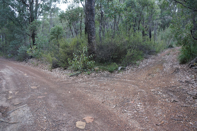
Marginata Rd is one of the least well known Bibbulmun Track entrance points, but it is a crucial one to know if you are attempting to complete the sections from Brookton Hwy to Sullivan Rock in two day walks. Being an indirect access point requiring a walk down forestry tracks, it is also one of the more confusing as there are no signs indicating you are heading towards the Bibbulmun Track. Our first attempt at this entrance lead us in the wrong direction, and after another friend told us that they too took the same wrong turn, I thought it would be best to provide a photographic guide of how to reach the Bibbulmun from Marginata Rd.
Marginata Rd is a side street off Kinsella Rd, a gravel vehicle track that links Brookton Hwy to Albany Hwy. I have marked the turn offs for Kinsella Rd on the map above in green. You will need to zoom in to see the gravel road. Kinsella Rd is clearly signed on Brookton Hwy, but it is not as clear from Albany Hwy. The best way to identify Kinsella Rd from Albany Hwy is to look out for a cycle crossing sign a few kilometres north of the Jarrahdale Rd. Kinsella Rd is the turn east, with the west turn it faces being blocked off.
From Brookton Hwy, Marginata Rd comes after a distinct right bend on the road and from Albany Hwy it comes a short distance after Kinsella Rd crosses the Canning River. On Google Maps, the turn off is called Four Ways Road. This is incorrect - Four Ways Road intersects with Marginata Rd a bit further down.
When you reach Marginata Rd, there is a small parking bay on the side of the road. DO NOT continue any further down the road as it is within the Dieback Risk Area.
Follow Marginata Rd. You should see a sign warning that a gate is ahead, presumably to keep cars from entering the Dieback Risk Area.
Pass through the gate. It seems to be open most of the time, but it should not be too difficult to walk around, under or over if it is closed.
A very short distance after the gate, there is a fork in the road. Looking at Google Maps, Nearmap and even the Bibbulmun Track maps will make you think that this is Four Ways Road - the road you will need to travel on to reach the Bibbulmun. This is NOT Four Ways Road and is instead a short, unnamed road that is not mentioned or even drawn on the maps, hence leading to the confusion. This road will lead to a dead end after wasting your time walking quite a few kilometres, so continue left.
After the fork in the road, you should see this reference tree a short distance later. If you see this tree you are on the right track.
From there, you should reach Four Ways Rd, a right turn off Marginata Rd. Take this road. The turn off from Four Ways Rd to the Bibbulmun Track is a few kilometres down the road, and is not particularly clear. There are Waugals on both sides of the track so keep an eye out. Turning left will take you to Brookton Hwy via Canning Campsite, while a right turn leads to Monadnocks Campsite via the Canning River.


Thank you so much. We are planning on trying this in a few weeks (doing our first overnight home staying at Monadnocks campsite), so hopefull we won't get lost now. Cheers.
ReplyDeleteThis post was really useful for us, we wouldn't have started from Marginata Rd without it.
ReplyDeleteThe instructions are spot on, look out for the misleading side road and keep a fairly careful eye out for the Bib track crossing.
One word of warning for others, as of October 2017 the Marginata Rd sign has disappeared, and the distinctive Gate sign is also hidden from Kinsella, so we weren't 100% sure we were at the right road.
The bridge over Canning River is the best reference point, from Albany Hwy it is another couple hundred of metres, from Brookton Hwy you've gone too far!