

Day two of a the Wilsons Promontory Southern Circuit, this day traverses the beautiful beaches between Sealers Cove and Little Waterloo Bay. The best beach-focused day of the track, walkers are taken to the beautiful beaches of Refuge Cove, Northern Waterloo Bay and Little Waterloo Bay, as well as the coastal views from Kersop Peak. Featuring some excellent forest walking as well, this is another excellent day on the circuit
Distance: 13.1 km (one way; 12.5 km for main track + 600 metres for the side trip)
Gradient: A few moderate descents and ascents with mostly gentle terrain
Quality of Path: Largely clear and well maintained
Quality of Signage: Largely well signed, with clear signage at trail junctions and major landmarks
Experience Required: Previous Bushwalking Experience Recommended
Time: 4.5-5.5 Hours, including lunch
Steps: Several steps along the track, particularly along the ascent and descents from the beaches.
Best Time to Visit: All year
Entry Fee: No, however a camping permit is required for all campsites in the park and must be booked in advance
Getting There: No direct access to this section of the track. This is a walkers only section of the park. Entry Fee: No, however a camping permit is required for all campsites in the park and must be booked in advance

Having flown into Melbourne on a flight that required me to wake up in Perth at four in the morning, I was pretty tired after the first day of walking and had a fantastic night's sleep at Sealers Cove. Having fallen asleep by 8pm meant I had had an excellent 10 hours of sleep by the time I woke up for a somewhat cloudy sunrise at the beach.

While I was well rested and out and about exploring the beach, Zach had had a terrible first night. Not familiar with the shape of the Big Agnes Seedhouse tent, he had not really thought about the fact that the small end is meant for his feet and slept with his head in the cramped bottom end rather than sleeping with his head near the spacious door side! Additionally, when we had set up the tent, I had oriented it with the door facing the way it was so that the slope would be heading down towards the feet. As a result, Zach was sleeping with blood going to his head in a cramped part of the tent with unfamiliar gear and in an unfamiliar location, which resulted in less than three hours sleep after already having had little sleep the previous evening. I also discovered at dinnertime the previous night that Zach had not packed enough food for the trip, having somehow thought we were only going for three days - and even then the calories in the food he had chosen were not quite enough and differed greatly from the food list I had suggested he pack!

After eating breakfast and packing up, we headed out for day two of the walk. Rather than exiting at the beach, the trail runs off through the forest near the large granite boulder in the middle of the campsite.

While I much prefer the look of smooth barked Eucalypts, the forest near Sealers Cove provided enjoyable forest walking before heading towards the headlands along the coast. Along the way, the track passes a rangers hut which is probably manned during the extremely popular Summer season. I know that a lot of Australians are against huts along walks (and that it has attracted less than desirable people to the huts in New Zealand), however I felt that this was a walk that could very easily support some low key public huts. Unfortunately, most hut developments in Australia these days tend to lean towards luxury private huts that will charge thousands for the privilege rather than making it an experience that is open to all.

The track heads up along the granite headland that encloses Sealers Cove. Even with the somewhat cloudy skies, the views across the cove were excellent, and reminded me a lot of the kind of beautiful coastal views that are so much a character of Australia's granite-rich south coast.

With the track leaving the bay and heading along the coast as it faces the open ocean, the trees gave way to stunted Eucalypts, grass trees and coastal heath that reminded me a lot of coastal walking along the Bibbulmun Track near Cosy Corner or near near Little Beach in Two People's Bay.

Continuing along, the track changed character again as it entered a small valley filled with a tall Eucalypt forest. The trees in this forest looked like they had been badly burnt in years past but had recovered very well even if they still bore the char marks of fire. It made me realise how much a wide crown can give a burnt forest a much more appealing character than the open canopy of certain scrappy regrowth Eucalypts with small crowns that look hideous for years to come after a fire.

Out of the valley, the trail returns to coastal heath and granite that once again had a strong similarity to coastal walking in Western Australia's South West.

Heading across a large exposed slab of granite, Zach and I were privy to lovely views across the coast. While still a bit cloudy, it was obvious that the skies were clearing up significantly and we were looking forward to having better views as the day progressed. While on the granite headlands, Zach and I were also impressed to get two to three bars of mobile phone signal strength, which allowed us to message our families to let them know we were okay. While we did have some signal at Sealers Cove it was very intermittent, however being used to the often non-existent signal out on trails in Western Australia, have such excellent signal out on the trail seemed like a luxury!

Looking towards the south, Zach and I could see some of the Prom's other granite headlands - some of which we would be exploring later in the day.

As the trail descends away from the exposed granite slab perch high along the headlands, the track once again passed through dense Eucalypt forest.

Initial fairly dry in appearance, the forest become increasingly lush and wet. While lacking the smooth-barked trees of the Karri forest, the understorey have a very similar appearance to the Karri forests back in WA.

As the track descended through the forest, the understorey became denser and more lush, and we were excited as we began to see flecks of blue water through the trees as we neared the beginning of Refuge Cove.

Refuge Cove is the location of the next campsite along the circuit, and is a popular camping area for both hikers as we as those sailing around the Prom in yachts and other water vessels. As we arrived at the northern beach of the cove, Zach and I ran into a couple who were doing a day walk after having moored in the cove. From the northern beach, we could see their yacht near the campsite area at the southern beach.

With granite boulders all along the coast, the trail from the northern beach runs up through the forest once again as it leads to the campsites further south.

Leaving the north beach, the view back from the track was stunning, and with warmer weather and with more time I would have loved to have had a swim in the calm waters of the cove.

The first campsite at Refuge Cove is the boaters campsite, which features an interesting wall of wooden boards featuring the name of boats that have visited the area. It is a pretty cool display, and not like anything I've seen at a hikers campsite before.

Continuing along, the hikers campsite is separated from the boaters on the other side of a small creek.

This is another good campsite on the track, with a sheltered canopy over a fairly open and level area for tents. I didn't investigate too hard, but I didn't notice a water pipe from the creek as seen as Sealers Cove, and I wondered whether this campsite had such a feature.
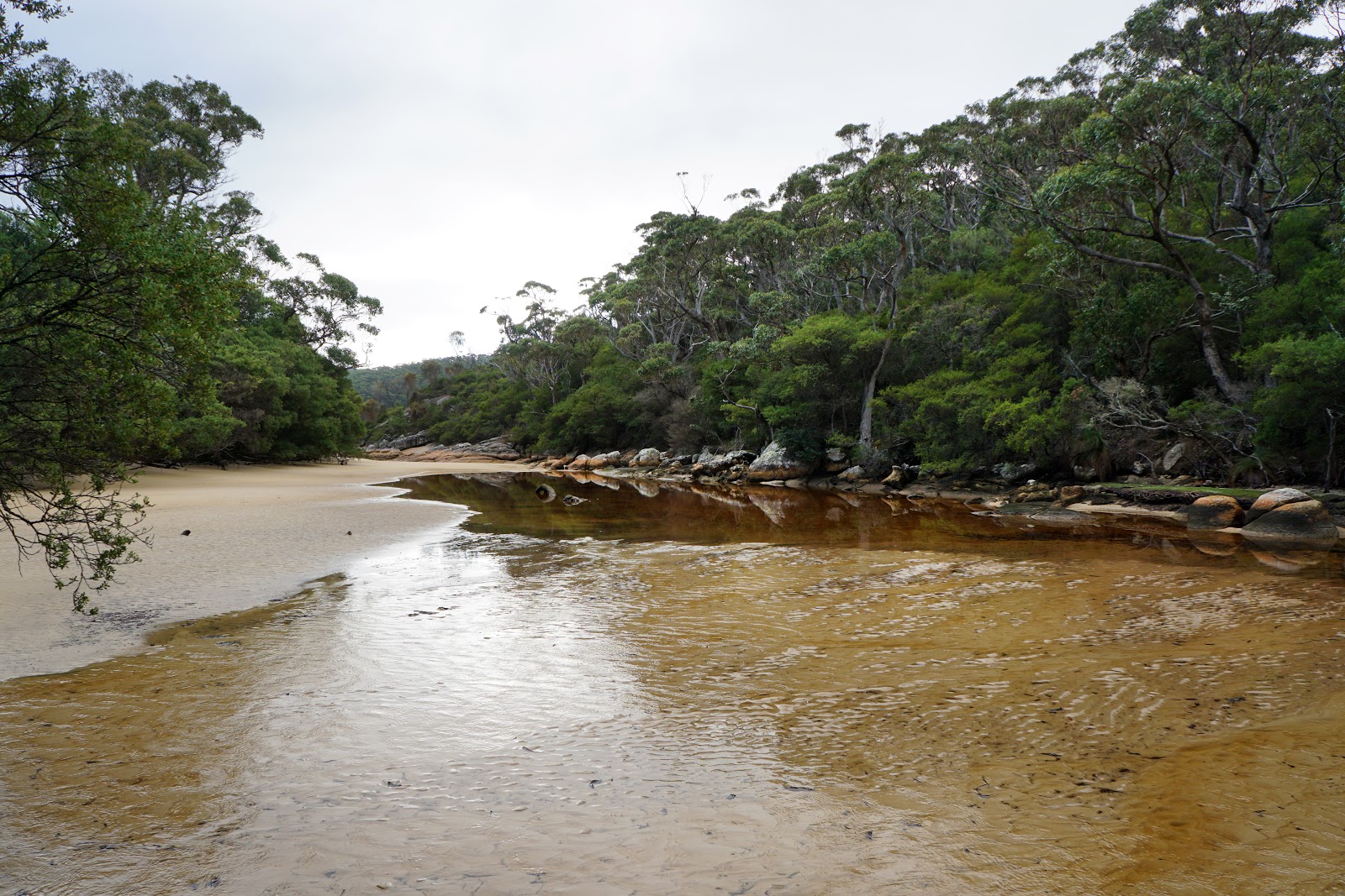
Stopping for lunch and with a low tide, I decided to head out and explore the creek as it flows into Refuge Cove.

I really enjoyed seeing the texture of the sand as it is displayed the wavy lines of the changing tides and the sand deposits flowing from the creek. I always find it fascinating when you climb a mountain like Toolbrunup in the Stirling Range or Mt Bruce in the Hamersleys and see these same lines in the rock up there as it is a sign that the rock once started its life as a sea or river bed that had been compressed and pushed up into the mountains we see today.

Looking towards the cove, I could see the yacht more clearly. I was glad that the yacht had been there at the time of our visit as it made the cove look even more idyllic than it already is naturally. At the beach to the left of the photo was the small landing boat that the couple we met earlier would have used to come ashore. After taking my photos, I joined Zach at the picnic table for lunch. My lunch was the typical mix of Le Snaks and Tuna to Go that is my staple for lunches on a walk. I had suggest Le Snak to Zach however he had decided to instead pack potato crisps and a warm can of V for lunch. I could not quite understand the logic of this as there are plenty of great junk food options that would have had a higher energy for lower weight and volume, but his unorthodox meal choices were highly amusing.

Upon leaving Refuge Cove, the track passes another granite slab with superb views back towards the cove. The blue waters and the wall of tall trees almost right to the shore were absolutely stunning, and it remains one of my favourite views of the entire walk.

The track rises fairly continually from the granite slab, making its way up a series of swtichbacks as it it led Zach and I to the trail junction at Kersop Peak.

With a lot of heath and stunted trees along the track, it wasn't clear just how far we had risen until we came to a ridge with good views back to the west. From here we could see that we had climbed some distance away from Refuge Cove, with the expanse of Hobbs Head dominating our view. Just behind it to the right is Horn Point.

After about half an hour of ascending away from Refuge Cove, the two of us reached the junction with the Kersop Peak side trip. Being a firm believer that the Long Way's Better and that it is worth heading of the main track to tackle side trips, I was very keen to head up to check out the views - especially since this was a lazy 600 metres return. The chance to walk a spur trail also meant that Zach and I could leave our packs at the junction and enjoy the lightweight luxury.

As is often the case, the side trip was less well maintained than the main track however it was still fairly easy to follow. The journey up to the peak was quite similar in appearance to walking along the Bald Head or Peak Head Walk Trails in Torndirrup National Park in Western Australia.

The view from the summit of Kersop Peak was spectacular. With the sun out and the skies clearing up, we could make out the long white beach of Waterloo Bay. To the left, we could see the headland of South East Point and its lighthouse. While we were at the summit, we met another hiker who was doing the same four day itinerary as we were, except that he was walking in the other direction. The anti-clockwise direction seems to be the more popular way of doing the walk in spite of the Chapmans' track notes being clockwise, and it made me wonder why they had written up the walk in this direction. Given that the book was written in 2003, it is possible that the ensuing 15 years has resulted in the walk's customary direction having changed and I would be interested to know when and why this happened.
The other hiker we met was about to head to the US to do some walking with friends in Yosemite, and was tossing up whether to do the Bibbulmun or the John Muir Trail in the near future. While being a traitor to Western Australia, I gave him my honest opinion of the Bibbulmun (there are outstanding world class sections like Balingup to Pemberton and Walpole to Denmark, but there are some very boring stretches as well), and suggested that the JMT would be a superior walk. He was grateful to hear my honest opinion, but I added that he should at least give Walpole to Denmark a go if he had the opportunity. We also chatted about Big Agnes tents as he had the same Copper Spur HV2 that I had, and he coincidentally had the same zipper break on his tent as mine. This made Zach feel a bit better as it wasn't just him who destroyed a zip on this trip!

Working our way back down to the main trail, we could see the next beach along - North Waterloo Bay. The other hiker let us know it was pretty much downhill all the way to the beach and then relatively easy going around the headlands to Little Waterloo Bay, so we had a fairly easy home stretch to tonight's campsite.


The forest types on display followed a familiar pattern as we descended to the beach, with Zach and I passing through coastal heath and thin, stunted trees before heading through lush, shaded forests.

Half an hour after leaving the summit of Kersop Peak, the two of us reached North Waterloo Bay.

After the yellow beaches of Sealers and Refuge Coves, I was excited to the white sands of North Waterloo Bay's beach. The white sands and granite boulders really reminded me of home on Western Australia's south coast. This could easily have been a photo of anywhere along the coastline between Albany and Cape Le Grand like Two People's Bay or Torndirrup National Park.

After getting our boots wet doing the knee deep crossing the previous day, Zach and I were pretty happy to have an easy trickle to cross as we made our way along North Waterloo Bay.

The track rises up off the beach as it passes by a huge jumble of granite boulders along the coast. According to the notes in Bushwalking in Australia, this stretch above the rocks used to be longer and more eroded, however the route now turns inland and takes a safer route to Little Waterloo Bay.


While inland is certainly safer in terms of avoiding the crashing waves, it also means dealing with the potential for fallen trees. A particularly large tree had fallen across the track at time that Zach and I did the circuit, and we had to climb over to get to the other side. Having climbed over a lot of fallen trees on the Bibbulmun Track (including a massive Red Tingle on the way to Frankland River hut!), this was pretty easy. As I often say - it is not a bushwalk through forest without at least one fallen tree across the track!

Continuing through the forest, the track rises slightly as it makes it way around the headlands to Little Waterloo Bay.

As we rounded the corner, the track began to run closer to the coastline. A large granite slab provided excellent views across to Waterloo Bay and Little Waterloo Bay.

The rugged walking along the way to Little Waterloo Bay was fun and exciting as we had to hop across a number of boulders cross a several streams as we descended to the beach.

Little Waterloo Bay shared the same white sands seen at North Waterloo Bay. Framed by rocky granite boulders and headlands, this was another beautiful beach along the track. As with the small creek at the previous beach, Zach and I had timed our visit well for a low tide crossing, and we were able to cross the creek fairly easily.

Looking back along the beach the track leading to the campsite runs parallel to the tannin-stained creek as it heads towards another sheltered spot away from the potentially strong winds right on the coast.

Zach and I were the first to arrive at Little Waterloo Bay and were able to take our pick of tent sites. We settled for the main area right in the middle of the campground as it meant easy access to both water at the creek and the toilet block. The area also had the best array of seating around its low square table and was vastly superior to the very muddy and wet area just beyond.

As with Sealers Cove, the campsite at Little Waterloo Bay features piped water from the creek for easy filling. While convenient, Zach and I agreed that the highly tannic water from the creek was the least tasty of the three creeks, having a slightly unpleasant taste. This was far from the luxury of the alpine water Alissa and I had in the Walls of Jerusalem at Dixons Kingdom, where we were basically drinking snow melt from the nearby mountain.
Feeling a bit sorry for Zach given his lack of food, I offered him a Cup A Soup as I brought one for every night and had not felt like one the previous day. Amazingly, Zach had never heard of Cup A Soup(!), but was grateful for the warm cuppa. While drinking his soup, I pointed out that he had a leech on his boot and he spilt half of the soup all over his pants as a result. Having so little food to eat, he was quite upset at his clumsiness. While I was certainly sympathetic, I couldn't help but laugh at this typically comical state of affairs. Seeing that he would not have enough food for the next day, I offered him one of my Le Snaks so that he had a bit more to eat. At first he would not accept it, but eventually relented.

Later in the afternoon, two high school groups arrived - first a group of girls who set up camp near the creek and a group of boys who had to set up near the toilets. Although they were large school groups, they were very well behaved and did not cause any disruptions for Zach and I. Having taken the best spot of the whole campsite made us feel a bit guilty, but hey - first come, first serve. One less than ideal aspect of the large group of boys is that someone pissed all over the seat, which was really disgusting! I felt very sorry for the girls as there was only one toilet at this campsite, and it was not like Sealers Cove where an alternative was only a short walk away.
Zach and I spent the rest of the afternoon climbing over the boulders at Little Waterloo Bay, which was a lot of fun. Reader of the blog may remember Zach's monkey-like climbing all over the boulders at the Lower Portals in South East Queensland, and I told him he would have loved the constant scrambling of Mt Amos in Tassie.
Sealers Cove to Little Waterloo Bay was another excellent day of walking. It was completely different to the more inland first day through the rainforest, having a lot more in common with the wild coastal walking along the south coast of Western Australia. Being a fan of the south coast, I loved the numerous beaches and granite headlands of the day. This definitely had the best beach walking of the Southern Circuit, and will be a favourite for fans of coastal trails while still offering some lovely forests.


High-quality tarpaulin—durable, waterproof, and perfect for outdoor use!
ReplyDeleteTarpaulins Cover