

One of Western Australia's most spectacular coastal walks, the Bigurda Trail takes walkers along an 8 km stretch of coastal cliffs in Kalbarri National Park. Linking Eagle Gorge to the Natural Bridge, this moderately easy trail features incredible views of the region's rugged, banded cliffs juxtaposed by wildflowers in a myriad of colours. A fairly unique experience, this is an essential walk of Australia's Coral Coast.
Distance: 8 km (one way)
Gradient: Fairly even and easy, with minor ascents and descents along the way
Quality of Path: Clear and easy to follow path. Surface alternates between sandy and unevenly rocky
Quality of Signage: Well signed over its entire length
Experience Required: Previous Bushwalking Experience Recommended
Time: 2-3 Hours (one way)
Steps: No steps, but uneven and steep paths are definitely not wheelchair accessible
Best Time to Visit: Late Winter-Late Spring
Entry Fee: No
Getting There: The trail starts at the Eagle Gorge car park, off George Grey Dr in Kalbarri. The trail ends at the Castle Cove car park; walkers will either need to walk back the other way, arrange a car shuffle/taxi pick up, or park a car at Castle Cove and cycle 8.7 km back to Eagle Gorge via the bitumen roads. Entry Fee: No

Other than the Loop Walk, the Bigurda Trail was a major reason for Alissa and I driving up for a weekend in Kalbarri. Traversing the coastal cliffs of Kalbarri National Park, the eight kilometre trail sounded pretty incredible, and although curiously absent from Trails WA's Top Trails, it was recently named as one of their Top 10 Trails in WA. Being a walk along the west coast, Alissa and I headed out in the afternoon with the aim of watching the sunset from the end of the walk.
Being one way, the Bigurda Trail requires a bit of pre-planning. Being such a long drive from Perth, bringing both our cars up to Kalbarri for a car shuffle was out of the question, and although there is a taxi in Kalbarri I am averse to paying the kind of fares taxi services ask for. Not wanting to make this a 16 kilometre return walk that would take up most of the day, I decided to pack my bicycle in the car with us so I could drop Alissa off at the Eagle Gorge end of the walk, drive the car to Castle Cove and cycle back to Alissa. I recommend the bike option - I was able to complete the 8.7 kilometre cycle in about 20 minutes, and DPaW even have bike racks at the car park!

After having a quick look at Eagle Gorge, Alissa and I headed to the informative trailhead for the Bigurda Trail, located adjacent to the Eagle Gorge car park. The trailhead provides a grid of distances to help walkers work out the distances between each of the trail's main features.

As with the Mushroom Rock Nature Trail from earlier in the day, the Bigurda was exceptionally well marked, with plastic marker pegs along its entire length making navigation very easy. The trail's symbol is the Bigurda - the Indigenous name for a Black Footed Wallaby.

The trail initially heads through coastal heathlands. One of the reasons we had come to Kalbarri in late August was to see the wildflower displays; we were definitely not disappointed, with bursts of colour throughout the heathlands.


The trail veers right, eventually running right along Kalbarri's coastal cliffs and providing walkers with excellent views of the Indian Ocean continually crashing into the Australian mainland.

In the risk averse times we live in, it was heartening to see that the trail stayed fairly close to the cliff's edge, with no overly protective railings to ruin the natural beauty. The trail leaves a large enough gap from the cliff's edge to ensure walker safety, with the intense winds off the Indian Ocean working as a back up safeguard - you'll definitely see why so many sail ships crashed into this coastline!


The terrible weather that had scuttled our plans for a morning walk in the gorges lingered on during our walk, with gloomy storm clouds providing even more brooding beauty to the landscape. The weather would constantly alternate between moderately heavy rain to grey coulds to moments of sunniness, and we were very thankful for having quick dry clothing.

Much of the first half of the walk stays close to the cliffs, with the occasional section heading back into the heath. While the heath sections would be less spectacular at other times of the year, the amount of wildflowers on display made these sections very much worthwhile.

Nearing what we thought was the halfway mark, the track turns inland around a small cove.

A faint but nevertheless discernible trail leads down to a beach at this point, however I would question the sanity of anyone who wanted to go for a swim in these wild waters. Having to keep to a strict timetable to make it to Castle Cove by sunset, Alissa and I didn't explore this side trip. Which is just as well - Alissa had thought this was the Grandstand she had seen halfway along the track map, however we would soon discover that we were still about a kilometre away from the halfway point.

The coastline gets more and more rugged and spectacular after the cove/beach. Some sections of the banded cliffs jut out precariously into the ocean, defying gravity for the time being before the ever-pounding waves cause the sandstone rock face to inexorably collapse into the ocean.
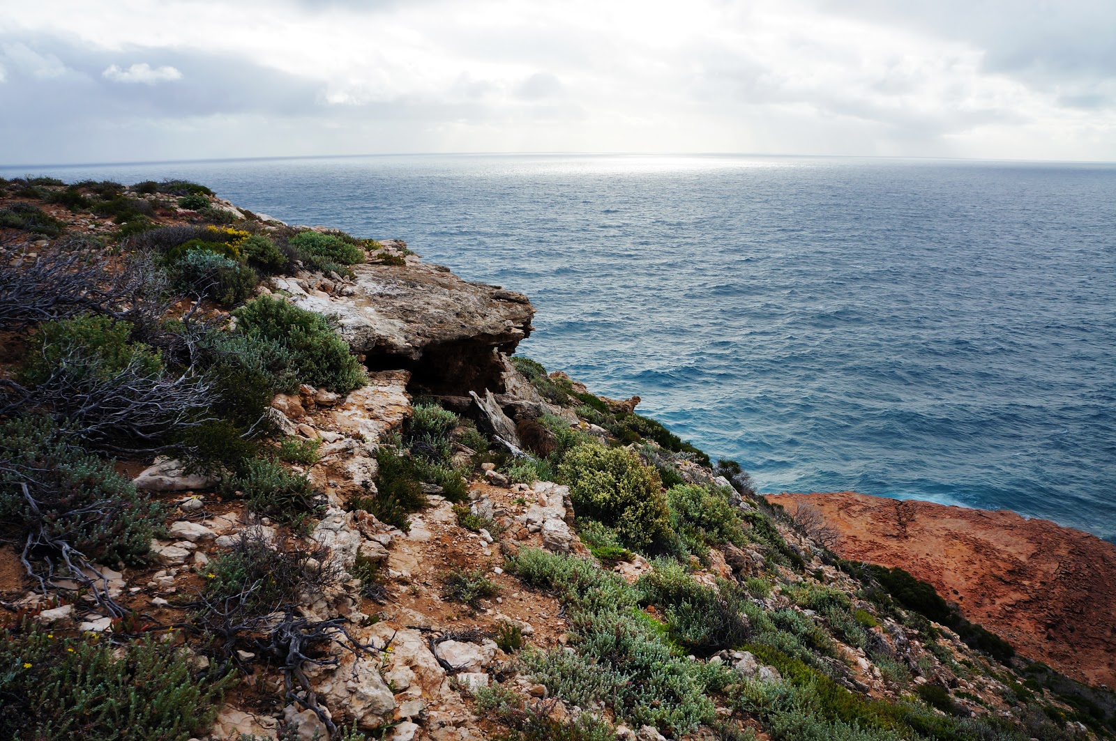
Although red sandstone dominates the lower layers of the Kalbarri cliffs, limestone appears to dominate the upper levels. Many small caves can seen along this stretch of the walk, however are perched precariously close to the cliff's edge and are thus a bit dangerous for humans to explore.

Looking down the slopes, walkers will clearly see how much of the upper layers have collapsed as rubble down to the water's edge - an important reminder of how fragile these coastal cliffs can be.

As I was photographing the cave and the collapsed section of cliff, Alissa alerted me to a strange sight - a massive pile of bees on the ground of the track itself! Alissa and I guessed this must have been a bee hive, however it was odd that a hive would have been built right on the ground instead of on the cliff face, especially with a much more hospitable cave just metres away.

Not far from the cave, collapsed rubble and the bees is the Grandstand - an impressively massive cove.

At this point, Alissa realised that this was the major landmark about halfway, being far more impressive than the smaller cove we had mistaken for it earlier.
The Grandstand is definitely one of the trail's highlights, and it was unsurprising to find that a lookout had been constructed on the Grandstand's southern side, providing the gorgeous vantage point above.

With a car park nearby, the trail follows a sealed path for some distance before returning to the wilder limestone and sand path we had encountered for most of the walk.


Even after the spectacular Grandstand, the Bigurda Trail still had more incredible formations in store for us, including the particularly banded section of the cliffs pictured above.

After some fairly gloomy weather for much of the walk, the setting sun finally made its way out from the storm clouds, bathing the coast in the glow of golden hour. It was interesting to see how the sunset complete changed the colour of the coastal cliffs, as the sun gave the rocks a yellowish appearance.

I had hopes that golden hour would hold out for us until we got to Natural Bridge, but it was not to be, with the cloud again obscuring the sun as we came close to the end. Though less intensely yellow, rays of the setting sun still gave the landscape a golden tinge as we came to see Island Rock and Natural Bridge.

Near Island Rock, the trail runs along a series of boardwalks through the heathland. Being near multiple car parks, this area is undoubtedly busier with casual tourists, and explains the sudden jump in trail infrastructure.

This area again features multiple lookouts, with walkers being privy to superb views of Island Rock. Still tenuously connected to the coastline, Island Rock has an appearance not dissimilar to the Twelve Apostles in Victoria.

The boardwalk continues to the final car park and lookout of the trail at Natural Bridge/Castle Cove.

The lookout overlooking the Natural Bridge serves as the terminus of the Bigurda Trail, offering walkers one last spectacular view of the Kalbarri coastline. Not to be confused with the Natural Bridge in Torndirrup National Park near Albany, Kalbarri's Natural Bridge juts out to the coast and is more exposed to the forces of nature. In time, the bridge connection will eventually collapse, with the stack becoming a second Island Rock.
As we watched the sun's light begin to dissipate, Alissa and I agreed that this was a fitting ending to what had been a really superb walk. Being used to coastal walks in the South West, the Bigurda Trail offers a really unique and very different take on the Western Australian coast, with the banded sandstone cliffs being just as beautiful in its own way as the granite-dominated coastline seen along such walks as the Meelup and Bald Head Walk Trails. While the Bald Head Trail's more adventurous terrain probably still has the edge on the Bigurda Trail, the Bigurda's moderately easy terrain and the continually astounding nature of this stretch of the Kalbarri coast marks it as a must do experience in the Mid West region, and one of our favourite coastal walks to date.


0 comments:
Post a Comment