

Part of the Churchman's Bushlands trail network, the combined Kangaroo and Echidna Trails are a stunningly diverse loop walk in the Perth Hills. Starting in Jarrah forest, the trail leads to excellent views of the city from a grassy field before running along the Canning River Valley. Finishing with a bang, the trail leads to The Wall - a superb rock climbing wall - before looping up to the top. An enjoyable and underrated walk.
Distance: 9.5 km (loop)
Gradient: Alternates between relatively easy, gentle gradients and section of steep terrain, with some scrambling required if taking the difficult route up The Wall
Quality of Path: Mostly on clear vehicle tracks, with some single file walk trail near rock climbing wall
Quality of Signage: Decent, with markers along most of the trail. Walkers are advised to refer to the City of Armadale's walk trails guide for a decent mud map
Experience Required: Previous Bushwalking Experience Recommended
Time: 2.5 Hours
Steps: Many formal steps near The Wall
Best Time to Visit: Autumn-Spring
Entry Fee: No
Entry Fee: No
Getting There: The trail starts from a car park at the end of Beeloo Place. From Albany Hwy, then left onto Waterwheel Rd and then take the immediate left onto Canns Rd. Turn right onto Churchman Brook Rd. 1.2 kilometres down the road is the left turn onto Beeloo Place.

After hitting the trails hard with a thru-hike of the Cape to Cape Track and an attempt at the Stirling Ridge Walk, I had grand plans for another busy Outdoors October like last year. This initially included a return visit to either Fitzgerald River National Park to do the Hakea Trail or a return visit to Kalbarri, finally doing the Yaberoo Budjara Heritage Trail from Joondalup to Yanchep and Kurliiny Tjenangitj Trail in Wellington National Park, however I was becoming increasing concerned about my recent bouts of foot pain and decided to ask my physiotherapist what he made of it. He diagnosed the foot pain as a classic case of Plantar Fasciitis. Knowing my usually hiking habits, he knew he wasn't going to be able to stop me from getting out on the trails but he did encourage me to take it easy. After a weekend without walking, electroshock therapy (for my foot muscles, not brain!) and a lot of stretching, Alissa and I headed out to Churchman's Bushland to investigate a couple of walk trails we'd heard very good things about.
Catalogued by Roleystone resident Bill Scott and popularised by Mark from the Life of Py, these trails are relatively obscure walks that have gone by many names, however have been standardised as the Churchman's Bushland Trails as part of the City of Armadale's work to realign their tourism strategies under the Perth Hills brand. Although they consist of a number of short loops, it is possible to combine two walks - the Kangaroo and Echidna Trails - to create a substantial 9.5 kilometre walk loop.

Given the somewhat open-ended nature of the Churchman's Bushland Trails, the walks can be started from a number of entry points, however we decided to use the City of Armadale's recommended start point at the end of Beeloo Place. This is a sensible choice as it places walkers near an obvious orange trailhead, and allows walkers to get the easier and less exciting part of the walk completed early on if walking in a clockwise direction. Following the signage by heading west along the Kangaroo Trail, the trail passes an old abandoned airstrip that was used in the 1960s for aerial top dressing and seeding. While it has fallen into disuse, the fact the airstrip hasn't become overgrown suggests that the grassy area is nevertheless maintained and could potentially be used in an emergency situation.

Along the trail are a series of markers for the Emu and Kangaroo Trails. There seems to be a bit of confusion about which trail is which, as from what we could tell the Kangaroo Trail was the longer of the two. Given the occasional lack of clarity, walkers are advised to refer to the informative Walks and Trails Guide put out by the City of Armadale.

After the airfield, the first kilometre of the walk was fairly uneventful as it consisted mainly of stock-standard Jarrah forest that is typical of the Darling Scarp area. We were however walking the trail in mid-October, and as a result we were gifted with a spectacular wildflower show. The banksias in particular were a definite highlight of this early section.

Memories of the Channel 10 Tower Walk came flooding back as we passed a Telstra Communications Tower. As with the Channel 10 Tower, I didn't find this to be a particularly awe-inspiring sight, however it an unmissable landmark along the walk trail.

Continuing westward along the outer edge of the park, the trail passes a few mature Jarrah. While not exactly towering, they helped improve the somewhat scrappy appearance that predominates much of the forest along this part of the walk.

The most interesting sights along this stretch were closer to the ground. Being a somewhat warmish day, I was definitely keeping an eye out for snakes, and we spotted one writhing around just to the left of the track. We gave the snake a decent amount of space and we parted ways without any issues.

Not all things that were close to the ground were dangerous however, and we were rewarded with a ground cover of beautiful blue wildflowers along the same stretch of track.

The City of Armadale brochure had hyped up 'breathtaking views of the City' along this trail. This is a fairly common track note that is said about almost every trail that has views overlooking the Swan Coastal Plain, but in this instance the hype was justified. After passing a row of pines and entering a grassy clearing, this really was one of the better views of the City along a trail. The view was definitely helped by the dead tree seen above, which added a moody point of interest to the foreground.

The trail through the grassy field in not clearly marked, however it is fairly obvious that walkers will have to make a sharp right turn and head along a vehicle track through the field. The appearance of a kangaroo marker on a tree was a comforting confirmation that we were indeed going the right way as we followed the vehicle track around the bend.

This next stretch was one of my favourite parts of the walk. Cut into the hillside, the trail follows a vehicle track along the Canning River Valley, and we enjoyed the views up and down the valley slope. I particularly appreciated the section where the Jarrah forest gave way to Wandoo - my favourite Eucalypt in the Darling Scarp area.

The trail continues on until it reaches a T junction. At this point, walkers looking to only do the Kangaroo Trail would turn right and follow the trail back past the old airstrip and to the car park. Although the seven kilometre Kangaroo Trail loop is an acceptable length, Alissa and I were definitely looking for something more substantial and we followed the orange arrows by turning left and descending towards the Canning River. These orange arrows are the markers for the Echidna Trail - a loop extension that takes walkers to some of the most scenic sections in the Churchman's Bushlands area.
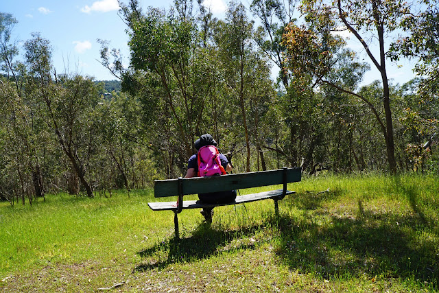
Descending towards the river, Alissa and I had our first encounter with some pretty nasty ants that crawled all over our shoes. We'd encountered this same species of ant when we did the nearby Wungong Gorge Walk GPS Route, and found them to be relentless once they smelt the blood of their fallen brethren. Luckily a bench at the bottom of the hill provided us with a good spot to stop and dust off as many ants off us as we could. The bench must have once offered good views of the Canning River in the past, however by the time of our visit the trees had grown tall enough that they blocked any particularly impressive views.

Turning right and following the markers along the river, the views of the Canning River Valley were quite impressive and made for very enjoyable bushwalking. Having very gradually descended from the top of the hill, we were slightly surprised by how far down we'd come, and we both knew that this definitely meant that some hill climbing would be in our future.

But for the time being we were enjoying the very pleasant, easy walking along the river. There were several decent vantage points that provided views of the Canning River, as well as many (sadly camera-shy) kangaroos hopping through the grasslands.

The easy, pleasant walking ended as the trail markers indicated that we had to turn up an old vehicle track that rises up the hillside. I would consider this an easy to moderate ascent, however we found the area to be infested with the ants we'd encountered earlier. Having smelt the blood of the ants we'd dusted off, they pursued us relentlessly and I ended up running most of the way up the hill. Alissa, who was a bit behind me to start with, was wondering why I'd rushed off ahead, however it all became clear to her once she'd stopped to catch her breath and found the ant armies starting their attack run. Having eventually found a section of the track without ants, I waited for Alissa as she ran to catch up. Up to this point I would say that the Kangaroo and Echidna Trails had been relatively family friendly but I would caution hikers to beware of these ants as they are doggedly persistent!

With the ants behind us, Alissa and I continued on straight down the track until we reached a private property and a road access point. Apparently, Moondyne Joe's Cave is located on the other side of the road, however it is not part of the trail. With no obvious trail markers nearby, we realised that we must have missed a trail junction in our haste to escape the ants, so we doubled back in hopes of find the right way to go.

Sure enough, a turn off was clearly marked in this direction, with the trail continuing up the hill as it leads to the rock climbing destination known as The Wall.

Most of the Kangaroo and Echidna Trails up to this point had been along vehicle tracks, however the trail to The Wall is a dedicated walking trail. The wildflowers on display were again quite spectacular, with the ascent providing good views across the Canning River Valley.

After pushing through some slightly overgrown bushes, Alissa and I were finally at The Wall. This had been the part of the walk I was most looking forward to after reading Mark's rave review of the trail.

Composed of Dolerite, the Wall is made from the same rock type that many of the mountains in Tasmania are composed of, such as Cradle Mountain and Mt Ossa. Unlike many other rock walls in Perth, The Wall looks to be a more natural rock face rather than the abandoned quarries that are more commonly found in the hills. The trail to the left apparently takes walkers up a new and more safe route to the top of The Wall, however we decided to check out the set of stairs to the right as a couple of rock climbers were in the area.


The climb up the right side of the rock face is very steep, and requires a bit of scrambling up a somewhat eroded path; it's certainly not a rock climb but it is a bit of a technical section that should be avoided by less experienced walkers.
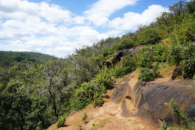
The reward for taking the more difficult path is the excellent views walking across the top of The Wall. The views of the surrounding forest and hills makes this a particularly picturesque spot, though walkers need to be careful not to go too close to the edge as the rocks slope downwards and there are no safety railings.

Pushing on towards the other end of the wall, Alissa and I found a set of stairs along an overgrown path leading to the top. Given that the trail that turns left at the bottom of The Wall is the easier way to go, it looks like few people choose this more difficult route.

Emerging from the overgrown steps, Alissa and I realised that the trail had taken us back almost directly to the car park, with our car clearly visible from the ascent.
Having been impressed by our off-track adventure in Wungong Gorge earlier this year, the Kangaroo and Echidna Trails were more underrated gems in the City of Armadale, with their marked nature making them a lot more accessible to a general audience. What I really enjoyed about the combination of these two trails was the variety of scenery on offer; whether the grassy field with its views of the city, the easy section along the Canning River or the rugged walking around The Wall, this loop kept things interesting and enjoyable. While we'll definitely keep an eye out for those ants next time, Alissa and I enjoyed this walk so much that we'd happily add it to our regular rotation alongside such favourites as Kitty's Gorge, Eagle View, the Mason and Bird/Victoria Dam Loop, Mt Cooke and the Numbat Track.


0 comments:
Post a Comment