An overnight or long day walk in Lesueur National Park, the Yonga Trail explores offers an extended exploration of Lesueur's varied landscapes. Starting near Mt Lesueur, the trail leaves the shorter day walks to explore a mix of Wandoo Woodlands, sandy open heathlands and the heath covered laterite ridges. Featuring a lovely campsite halfway, the Yonga Trail is well worth exploring during the wildflower season
Distance: 26 km (loop)
Gradient: A mix of moderately steep ascents/descents and some easy, flatter sections
Quality of Path: Clear and easy to follow path, though indistinct at times. Surface alternates between sandy and unevenly rocky
Quality of Signage: Well signed over its entire length
Experience Required: Previous Bushwalking Experience Required
Time: 2 Days or a very long day walk
Steps: Some steps, both formal and informal
Best Time to Visit: Late Winter-Mid Spring, but best during the wildflower season
Entry Fee: Yes. National Park fees apply
Getting There: Lesueur National Park is located off Cockleshell Gully Rd, north east of Jurien Bay. A one way road runs through the park, leading to a car park and trailhead at Mt Lesueur

While Western Australia has been making an admirable effort to position itself as one of the best mountain bike destinations in the Southern Hemisphere with some impressive turbo-charged trail building in the last few years, it is not everyday that hikers get the pleasure of walking a brand new walk trail on the west coast. With WA's limited hiking trail supply and a massive influx of newcomers joining the hiking community, news of a 26 kilometre loop walk with overnight camping being built in Lesueur National Park was extremely welcome - particularly since it represents a very different landscape to the usual coastal and forest dichotomy that has been the main focus of overnight trails in WA. Named the Yonga Trail, Alissa and I headed up in mid-September a few weeks after the trail's opening in late August to check out what this trail had to offer.

Lesueur National Park is well known for being one of the best wildflower parks in Western Australia, being held in a similarly high regard as Stirling Range and Fitzgerald National Parks in terms of biodiversity and botanical significance. Given the area's significance as a conservation reserve, boot cleaning stations are located at the start of the walk to help mitigate the risk of Dieback spreading throughout the park and maintain the area's beauty.

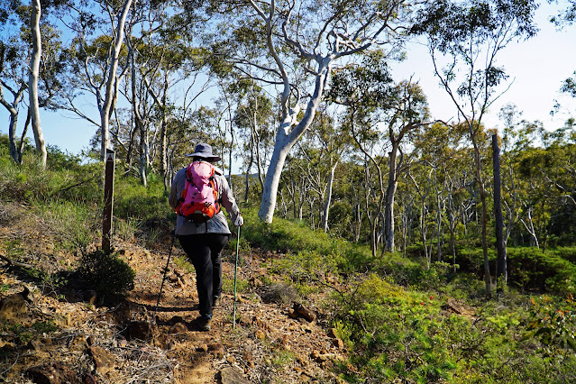
From the trailhead, the Yonga Trail initially follows a short section of narrow walk trail before joining a vehicle track. This is the same vehicle track that can be seen at the end of the Gardner Trail, one of the original walk trails in Lesueur that Alissa did back in 2016. Given that using existing vehicle tracks is the lowest effort and least interesting way of making a walk trail, I was concerned that the Yonga Trail was going to be entirely on broad vehicle tracks, so I was very relieved when the vehicle track section was mercifully short-lived. The Yonga Trail would occasionally use vehicle tracks throughout the walk, but in most cases the trail runs along an impressive amount of single track.

Leaving the shorter day walks behind, I was glad to see that trail signage was of a very high standard. At the time of writing the trail did not have a publicly available map/brochure like the overnight hikes in Fitzgerald River National Park, so these signs are crucial for walkers in the early part of their Yonga Trail journey.
One aspect of walks through the Jarrah forest that I've been critical of is a sense that it all becomes a bit samey, with little geographical or geological interest. This is not a problem on the Yonga Trail in general, as the trail designers have clearly picked a route that understands what hikers actually want to see and providing for a walk with a lot of variety. With the vehicle track walking literally a few minutes in our past, I was impressed to head across a rugged, rocky hill along hand cut trail that then descended into our first stand of Wandoo woodlands.

With the open heathlands that dominate Lesueur National Park, the lack of shade can be brutally unforgiving and for this reason being able to walk through areas that have some semblance of a canopy offer relief. The fact the area's tree of choice is the Wandoo make it that much more special; in the South West, Jarrah dominates the scenery on a vast majority of the area's trails while the prettier, smooth barked Wandoo that is found on the eastern side of the scarp is oddly underrepresented in spite of the more open understory being highly suitable for bushwalking. While Dryandra Woodlands, the Numbat Track and many WalkGPS walks have represented the Wandoo woodlands well, it is great to see DBCA build an overnight trail with such a strong focus on this lovely eucalypt.

Flitting between Wandoo and more open heathlands, the wildflower display was as excellent as one can expect for an area with Lesueur's reputation as a one of the best wildflower-focused national parks in the country. That being said, at this early stage Alissa and I were still waiting for that sledgehammer-to-the-face-level of spectacular we'd experienced on the Yued Ponar Trail - the last new walk that opened in Lesueur back in 2019 that saw us walking through corridors of wildflowers in bloom.
The trail must have been listening to our conversation; as we cleared a section of Wandoo and entered another area of open heath, we were surrounded by a solid wall of yellow wattle that continued for a solid section of trail. Where earlier sections had felt clearly hand cut, this stretch of the trail had a wider machine cut feel that will over time grow back into a narrower corridor.
Reaching a broad vehicle track, the Yonga Trail takes a sharp right as it follows the track through a stand of Wandoo before branching off again to follow narrower walker scaled tracks through the woodlands and heath.
The constantly changing vegetation means that there's a seemingly endless parade of different wildflowers along the trail. As someone who has embraced the faster speed of bikepacking of late, I'm not a particularly committed wildflower spotter but even I was taken by the sheer number of species on display along the walk.
The flowers are just one impressive aspect of the trail; the birdlife was also a notable highlight. The entire walk was soundtracked by constant birdsong. While the lack of shade gives the area a dry and somewhat inhospitable appearance for humans, it seems like a myriad of cockatoo species are thriving in Lesueur given Alissa and I encountered so many of them along the walk. The Pink and Grey Galah pictured above was the only one I was able to photograph, however we also spotted Corellas and Kaaraks (Black Cockatoos), as well as many smaller parrot species.
The size of the Wandoo is also another point of distinction along the trail. Wandoo is a slow growing Eucalypt, and yet there are some considerable giants amongst the woodlands, including the somewhat stately example above.
Not long after appreciating the tall Wandoo of the woodlands, the trail enters one of its longer stretches through the heathlands. Through this section, Alissa and I both started to feel the heat getting to us. While the maximum temperature forecast was 20°C, the non-existent tree cover in the open heath sections and the lack of wind given their location in the lower lying areas made it uncomfortably warm. We had worn loose fitting long sleeves for the Sun and tick protection factor, however we were so hot and uncomfortable the long sleeves were off for the rest of the walk.

While uncomfortable, at least the wildflowers provided a lot of interest, however it highlighted a bit of a conundrum when it comes to this walk; the ideal time to walk the trail temperature-wise is probably in the cooler months (June-August), while the best time to walk the trail for wildflower spotting is in late August through to early October. The overlap of perfect weather and scenery is a very narrow window, however given how much better the parks looks during the wildflower season it is probably a case where I'd recommend hikers just grin and bear it when it comes to the heat.

Reentering Wandoo woodlands was almost literally like a cooling balm, however we were surprised to find this newly opened trail looking a bit indistinct in a few places, such as along the dry creek crossing seen above. Luckily the signage for the trail is very good and it was easy to work out where the trail was supposed to go. Every time Alissa and I have been to Lesueur, we've never seen any of the creeks flowing, which suggests they are extremely ephemeral water courses that only flow after serious rain run off.
After so much open heath walking, it was lovely to be back amongst the Wandoo, and reentering Wandoo constantly lifted my spirits whenever I started to tire of the oppressive sunshine of the open heathlands sections.
The Yonga Trail is so named due to the area being located in the lands of the Yued Noongar dialectical group, and yonga being the Noongar word for kangaroo. This choice of name was rather apt; while we spotted very few kangaroos along the way, their prints could be seen very regularly along the walk, with the sheer size of these footprints suggesting they were left by one of those super buff roided-out males.

Given the area's dryness and lack of flowing water, it made me really wonder how on earth so many birds and marsupials were surviving in what humans would consider a fairly harsh and inhospitable landscape. The answer was a nice surprise, as Alissa and I would encounter the first of many small pools along the trail. While fairly shallow, they provided a small oasis in the woodlands and heath. Given the overall dryness of the area, it really made me wonder whether these shallow pools were spring-fed, as it seemed almost miraculous that the water would remain in place at this particular point and yet be such a rare resource elsewhere in the park.

As a possible refutation of my conjecture that the pool was spring fed, Alissa and I did encounter some water along a rocky creek bed further along the way. While not flowing water, rain run off had pooled along the rocks. Given its smaller size and the open nature of the puddle's location, I did not think the water would last for very long, and thus would not be as reliable a water source as the pool we had seen earlier.
Having seen early promo photos that indicated that the trail's campsite was located within a stand of Wandoo Woodlands, Alissa and I started feeling a sense of anticipation every time we entered a new woodland section, even though Alissa was tracking the walk and we knew it was still a few kilometres to go. The Wandoo sections seemed to be getting better and better, and it really made for a very enjoyable walking experience.
Within a large, sustained section of Wandoo, it was interesting to see another pool of water, with this one being several times larger than the first. While in a more shaded spot, the size of the pool again made Alissa and I wonder if there was a spring fed component to its size, and if not for the heat it would be interesting to see what the area looks like in Summer to prove or disprove this theory.
Emerging out of the Wandoo, the trail passes across a grassy flat that looks almost unnaturally well manicured. Given the open nature of the landscape, there is no distinct trail through this section and instead there is a collection of branches placed by the trail builders to mark a clear line through the landscape.
While the trail had been somewhat undulating, reentering another pocket of Wandoo saw Alissa and I rising up a considerable ascent along a series of switchbacks. It made me think of the switchbacks I'd been enjoying riding on the Munda Biddi, however unlike the wide mountain bike-friendly switchbacks of that trail, these were super tight and clearly designed specifically for walkers.
Reaching the top of the ridge, it felt a bit like we had been made to rise up for no reason until Alissa and I cleared the woodlands. While heathlands had been a major feature of the walk already, the laterite ridges are home to different species compared to the sandy flats, and in a lot of ways are the most impressive sections of the trail when it comes to wildflower displays.
Descending the ridge, Alissa and I were awed by the beauty of the wildflower display and the somewhat orderly rock garden appearance that only adds to the scene's attractiveness. After taking a moment to appreciate the scenery, Alissa and I descended into another stand of Wandoo woodlands that would eventually lead us to the Yonga campground.
Those used to the Bibbulmun Track, the Munda Biddi, the Hakea Trail in Fitzgerald River National Park and even the Old Timberline Rail Trail will know that we're a bit spoiled in WA when it comes to hiking and cycling trail campgrounds featuring impressive, sometimes over the top deluxe hut and shelter-oriented facilities for free, and it is almost a bit of a shock to the system that the Cape to Cape campgrounds are so spartan by comparison. The Yonga Trail is unusual in Western Australia as it is the first to feature three tent platforms, and as another sign of the times is also the first that requires booking and a small fee.

As well as the tent platforms, the trail also features a small shelter in a simpler design compared to the Munda Biddi and Bibbulmun Track shelters. The shelter can be booked to camp under, however there is no clear etiquette about whether it is for the exclusive use of those who have booked it, or if it can be used by the tent platform folks to sit under in the case of inclement weather. Behind the hut is a water tank, and a toilet block is locate further up on the hill.

Overall, I feel like the tent platforms are a step in the right direction and I would love to see them implemented on the Cape to Cape Track given the somewhat muddy nature of campsites like Mt Duckworth and Moses, and the higher environmental impact these sites are experiencing given a recent boom in hiking. Not every trail needs to have a hut, and tent platforms are great from a sustainability perspective as they keep tents and tent pegs clean, thus reducing the potential spread of Dieback. While Alissa and I didn't camp overnight, we were informed by friends who did that the grate platform was not really ideal for setting up non-free standing tents, and a bit of constructive feedback I would give to DBCA is that they should copy the Tasmanian tent platform system where retractable chains provide perfect tent attachment points, as seen on the Overland Track, Walls of Jerusalem and Frenchmans Cap.

After stopping to feast on our packed lunch while the plentiful mosquitos at camp feasted on us, Alissa and I commenced what would be the second day of the trail for overnight hikers going in a clockwise direction. This is the longer of the two sections by two kilometres, however Alissa and I found it much more taxing than the first section had appeared to be.
After some easy flat walking through Wandoo woodlands, the trail dips down and up across a creek crossing - something that Alissa and I would get used to as a repeated feature of this stretch of the walk.
The next dip was even more pronounced, with quite a significant Wandoo-lined valley that reminded me of the very conspicuous rivers through the dry Gascoyne region which are the only places that you see significant tree cover. This valley was a lovely spot, and I remember vividly that the sound of birdsong was at its best through this section.
The trail rises quite steeply out of the valley, following rocky terrain as it reaches a high laterite ridge line filled with many of the same beautiful wildflowers we had encountered at the last laterite ridge section.
One of the best things about being up high on the ridge was that we were finally able to experience the cooling sea breeze, which was a much needed respite from the oppressive heat. The views across the national park were also fantastic; in the distance, Alissa and I could see the waters of Jurien Bay, and the wilderness of the National Park seemed to stretch out as far as the eye could see.

Alissa and I could definitely tell we were heading back to the start as the flat top mesas that Lesueur National Park is well known for came into view. What we hadn't quite realised at the time is that the trail basically overshoots Mt Lesueur (near where the trail starts) and instead follows a circuitous route back to that start point. As such, I definitely recommend not considering the relative proximity of the mesas as an indication of how far you are from finishing, unless you enjoy the feeling of disappointment when you realise you've anticipated an ending that is actually still a ways into the future.

Up to this point, I had been delighted by the fact the scenery along the walk had avoided the burnt out appearance that is a common unsightly scene in the Jarrah forest. While the walk had for the most part avoided blackened landscapes, at the time of writing the trail does pass through a section that has either been damaged by bushfire or a recent prescribed burn. Given the heat of the day and the open nature of this section, Alissa and I were looking forward to getting clear of it as fast as possible, and were thankful a fair bit of it was straightforward walking.
There were however a few sections that were a bit more undulating, with this very short and sharp quick dip and then rise being located near the edge of the burn zone.
After what seemed like an eternity of exposed walking with no shade and untidy, charcoal-heavy scenery, I was elated when we reentered Wandoo woodlands and what turned out to be one of the trail's best and most spectacular sections. The first major plus for this section is the sheer quality of the Wandoo woodlands, with the size of many of the trees suggesting this to be a very old woodland.

With the constant flitting between woodlands and heath, I was impressed that this stand seemed to last for quite some time. On top of that, the area featured a lot of geological interest as the trail follows a creek line and even passes by a cave that is located down in the valley. The cave is not easy to access as there is a steep off-track descent required, and it had me wondering if the area has any special significance for the Yued people. Given how temptingly cool the cave looks, it would be good if DBCA could put up some signage at this location to let people know whether access to the cave would be culturally appropriate or not, and to inform walkers of any cultural significance.
Rising through the forest and up to the top of the ridge, the impressive geological features continue. Winding its way up, the trail passes through some interesting rock features as the Wandoo slowly thins out to open heathlands once again.
By this stage, Alissa and I had been impressed by how much of the Yonga Trail had been on purpose built single track, and thus a section descending along an old vehicle track didn't feel like the trail builders had taken the cheap cop out option given how much effort had gone into the trail elsewhere.
The best thing about this section was that it was again heathlands of the laterite ridge variety, which meant that this was again one of the best sections of the trail for being surrounded by the colours of wildflowers filling your field of vision, and I was lucky enough to see a few butterflies through here as well.
With the trail curving down and around through the landscape, the flat top mesas returned to view, though as noted the apparent proximity may as well have been a mirage given the route the trail takes to get back to the start point. As the trail descends, the vehicle track transitions back into walker only single track as it enters a particularly rugged stretch of the walk.
Through this section the Yonga Trail crosses more dry creek crossings, however the creek beds through here were much more rocky, creating a bit of an adventurous feel with its natural and uneven surfaces. The level of rock smoothing from water flow definitely suggested a very ephemeral flow, and it would be quite a special and rare occurrence to be out on the trail with water flowing over the rocks.
Rising from the creeks, the trail follows a fairly rough and very uneven section of trail up onto yet another ridge line. There were sections of the trail that were uneven and rocky but this bit took the cake; it looked like they had merely pulled out the plants and did nothing to smooth out the trail. While the unevenness made it less comfortable for walking, it did make me wonder if this was better for trail erosion mitigation.
Once reaching the top of the ridge, the Yonga Trail follows the edge of a laterite breakaway for a short distance before descending yet again.
Given the use of somewhat conservative trail ratings on the Australian Walking Track Grading System and the fact a great and not particularly dangerous trail like the Bald Head Walk Trail has not been included on Trails WA's Top Trails list for safety reasons, I've often considered DBCA as an organisation with a particularly low risk appetite for potential visitor injury (sometimes excessively so in my opinion). It was surprising then to see such a steep, uneven and seemingly crumbly rocky descent coming down off the quite literal breakaway. While I like the hand made bespoke quality of the trail, this did feel like something that needed a bit more work to stabilise, and I do hope that walkers going in a clockwise direction who don't use trekking poles take it easy descending through here.
Beyond the laterite breakaway, the trail undulates through some more nice Wandoo woodlands before ascending along a vehicle track.
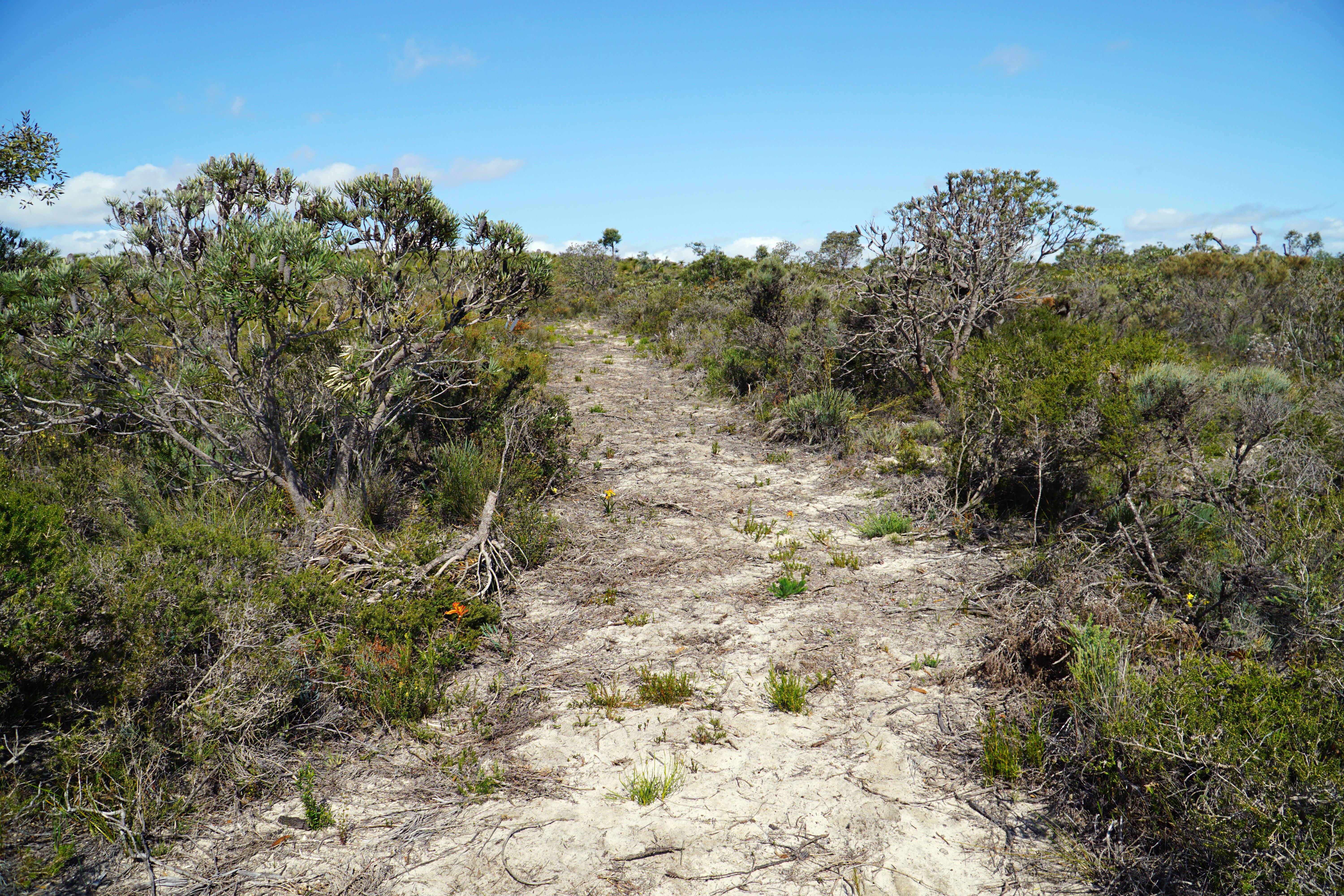
What follows is a section of more open woodlands mixed with heath as the trail heads through sandier, and less geologically interesting terrain. Through here the trail is mainly a faint pad, though the markers provide clear enough navigational direction.
While lacking in interesting rock formations, there was a noticeable change in flora given the sandier soil. Through this section, the Zamias were a major highlight. Zamias are an intriguing plant species as they are survivor from when Australia was predominantly covered by rainforest. In the Jarrah forest, Zamias seldom seem to get very big (presumably due to the frequency of prescribed burn cycles) however in Lesueur National Park, giant two metre tall examples seem to be the rule rather than the exception.
The wildflowers were again quite exceptional through this section, with Catspaws - the yellow, orange and red variety of the Kangaroo Paw - being particularly profuse right along the trail.
It had been a while since we'd had clear open vistas from a relatively higher elevation, and coming to another laterite ridge this was the point when Alissa and I realised how the Yonga Trail really overshoots the flat top mesas, as all we could see could see ahead of us was seemingly endless open heathland with little to no shade.
While I'm sure that the heat of the day and the fact we were doing the entire loop in one day coloured our perceptions, this long open heathland stretch was by far the least interesting part of the walk and really felt like a slog given the somewhat repetitive nature of the scenery. At one point the Yonga Trail crosses a vehicle track, and Alissa and I were definitely tempted to follow it if it meant getting back to the car earlier!

As I was walking through this section of heathland, I felt that it was a classic example of why I don't feel like some small wildflowers in an otherwise dreary scene are enough to save it and make it spectacular. During this stretch there were a lot of Catspaws all along the trail, however if you look at the photo above it shows that these bursts of colour probably amount for less than 0.1% of my field of vision, with the rest of it being very dreary greys, army green, khaki and white sand. I know other more committed wildflower spotters will say I'm missing the devil in the detail, but a tiny spec of spectacular amongst dullness just isn't spectacular enough to hold my interest. Give me the laterite ridges or the woodland sections any day over this sort of scene.

Transitioning back to Wandoo woodlands was thus a welcome return to form, with the trail remaining in the dappled shade of the trees almost all the way until the Yonga Trail joins back onto the shorter day walk loop near the car park.
Walking onward through the Wandoo, the trail passes through some fairly flat and open woodland sections before suddenly skirting the edge of what appeared to be a dam. This was a pleasant surprise, and while I'm sure it is not a natural body of water I'm sure the wildlife of Lesueur National Park enjoy what is probably a fairly reliable source of water for a good portion of the year.
Continuing on through the woodlands, signs of human intervention appear again in the form of some intriguing channels that cut through the landscape. As with the cave earlier, this and the dam could really do with some information signage so that walkers can interpret the heritage value of the dam and channel, as they surely must have been constructed for a reason that is somewhat opaque to walkers at current.

As we reached the edge of the woodlands, Alissa and I could hear voices nearby indicating we were either about to pass some hikers going in the other direction or were about to reach the shorter day loops. Leaving the shade of the Wandoo, the trail dips down and then rises steeply across an ephemeral creek line. Once reaching the top of the climb, Alissa and I could see the flat top mesa of Mt Lesueur with people walking up to the summit. With Alissa and I having done the walk before and being ready for this walk to be over, we did not add a side trip to the summit to our itinerary.
Alissa and I were pretty overheated and over walking by this point, so seeing the trail map sign was a real comfort to our weary feet and sweaty backs. As you can see, Alissa was well and truly ready for us to sit down and cool off in the air conditioned comfort of our car in the car park, which was reached after only a short walk along the Gardner Trail.
Having thoroughly enjoyed the Yued Ponar Walk Trail when we did it two years ago, I had high hopes for the Yonga Trail, and I have to say it largely lived up to my expectations.
Beyond the obvious attraction of wildflower-filled scenery, the main positive of the trail is that it provides a unique and interesting experience for hikers that is different to the current overnight trail offering elsewhere in the state, and the largely handmade nature of parts of the trail is a step in the right direction given how many trails in the Perth region are low effort affairs consisting of signage put up on existing vehicle tracks.
The trail's campsite is also a move in the right direction as well, given the use of tent platforms rather than the bunk bed sleep shelters of the Bibbulmun Track and Munda Biddi Trail. It may be controversial, but I'm also not against a small fee to book a campsite; while I think it is impractical to implement something like that for the Bibbulmun Track or Munda Biddi Trail, having to pay for campsites or a hiker's parks pass is fairly standard in other jurisdictions in Australia. If it means more trails get built and hiker numbers are better regulated I'm all for it.
The one negative aspect of the trail is that the best window of opportunity to do the trail is the wildflower season, however the open nature of the heathlands means it can be a stiflingly hot and sunburn-inducing trail to walk at the 'right' time of year. For Alissa and I, this was only exacerbated by doing the whole thing in one go, and I would definitely recommend walkers do the trail as an overnight if there is even a hint that it will be a cloudless, sunny day. Something else to be aware of is that this area is notorious for being home to ticks, and I was lucky that Alissa was able to find a tick that was on me before it attached. Walkers beware.
Overall, the Yonga Trail was a good trail, and one that gives me a bit of hope for the future of hiking in Western Australia; if this is a sign of where we're going with future hiking developments, I couldn't be more excited.


The Whatsapp Hacker APK can give you access to a user’s private messages. With the help of a WhatsApp keylogger, you can hack into the messaging app. This hack tool can read all the messages on WhatsApp from recorded keystrokes. Moreover, it has the power to spy on another user’s conversations without their knowledge. However, you should be careful while choosing a WhatsApp keylogger. It might not be safe and it might lead to unintended consequences.
ReplyDeleteWhatsapp Hacker APP
You have shared a lot of useful information on your blog. I like it very much.Now I have decided to share your blog link with all my friends through myFM Whatsapp Download so that they can visit your blog and get some amazing information.
ReplyDeleteI really love this type of content. Recently I've found https://spotilover.com that is also worth the time.
ReplyDeleteThis comment has been removed by the author.
ReplyDeleteThe Yonga Trail is a popular hiking trail located in Lesueur National Park, which is situated in Western Australia. Lesueur National Park is known for its diverse flora and fauna, including a wide variety of native plant species. The park is particularly famous for its beautiful wildflowers, which bloom in abundance during the spring season. https://capcuttemplates.org
ReplyDeleteBecause WhatsApp doesn't accept such things, I don't think Lucky Pitcher can be used with WhatsApp, but you can create YoWhatsApp or YO WhatsApp with it because I've used it on OGWhatsapp and it works perfectly.
ReplyDeletethe official whatsapp cant accept these thing for this type of features you should try updated fm whatsapp apk
ReplyDeletethis app provides you free music with wonderful no ads experience, thespotiapk.com
ReplyDeleteUnlock the ultimate music experience with the Spotify Student Discount, designed specifically for students. This exclusive offer lets you enjoy Spotify Premium at a reduced price, giving you access to ad-free music, offline listening, and unlimited skips. Whether you're studying or relaxing, immerse yourself in millions of songs and podcasts tailored to your taste.
ReplyDeleteinshot apk download new version is known for its simple and intuitive interface, making it an excellent choice for both beginners and professionals. The well-organized tools ensure that users can quickly edit videos without needing prior experience. With just a few taps, you can trim clips, adjust playback speed, and add effects to create engaging content.
ReplyDeleteI really love this type of content. Recently I've found https://www.spotifyinfo.com.br/ that is also worth the time.
ReplyDeleteIf you are an organizer, this Spotify APK iOS feature is going to give you satisfaction at its best as this allows you to create folders and organize your playlists according to your moods.
ReplyDeleteWith the evolution of AI power, Spotify has introduced an AI-powered DJ that accumulates the power of artificial intelligence and your history of music selection and then presents a playlist based on your taste, habits, and preferences.
ReplyDeleteYouTube++ iOS Premium is a paid subscription website that provides unlimited watching and downloading of videos without ads, with background playback.
ReplyDeleteGet free Snaptube iPhone APK! Snaptube downloader helps you download videos and music from internet to your Android phone.
ReplyDeleteThe latest Minecraft APK from https://minescraftapks.com.tr/ version has arrived, bringing exciting updates and improved performance! Build bigger, explore deeper, and enjoy a more immersive experience than ever before.
ReplyDeletehttps://theminecraftapk.com.tr/ adresindeki Minecraft APK, oyun deneyiminizi istediğiniz gibi şekillendirmenize olanak tanır. Kilidi açılmış özellikler, yaratıcı modlar ve geliştirilmiş görsellerle mobil deneyiminiz daha zengin ve daha heyecan verici hale gelir.
DeleteDownloaded Traffic Rider unlimited money last week — no regrets! Smooth gameplay, no annoying ads, and all the upgrades make it super addictive.
ReplyDelete"If dota 2 mmr boosting helps someone enjoy the game more and play with better teammates, I don't see the big issue as long as they're trying to improve too."
ReplyDeleteYou can instantly turn any photo into a mockup for posters, business cards, or billboards—great for freelance designers and clients. https://photoroomaiapks.org/
ReplyDeleteUnduh Nekopoi APK untuk PC dan nikmati konten anime eksklusif!
ReplyDeleteCukup instal emulator Android dan ambil APK dari: https://nekopoisapk.com/nekopoi-apk-pc/
This comment has been removed by the author.
ReplyDeleteThe multi-layer timeline in VN MOD APK FOR PC allows precise control over video, audio, text, and effects—making complex edits smooth and manageable.
ReplyDeleteQuería saber si mi cumpleaños caía en fin de semana este año, así que usé una calculadora para ver mi cumpleaños y cuánto falta, y la respuesta fue clara y rápida.
ReplyDeleteI really enjoyed this perspective—“The Long Way’s Better” is such a refreshing reminder that taking your time can lead to richer experiences, whether it’s in travel, learning, or creative work. Sometimes, it’s the scenic route that helps us grow the most.
ReplyDeleteFor anyone sharing their journey online or crafting content that reflects their personal style, adding a bit of flair to how you present text can make a difference. I often use tools like https://stylish-names.net/ to create bold or fancy fonts for blog headers, bios, or social captions. It’s a small touch, but it really helps your words stand out.
Explore the scenic beauty of Lesueur National Park on the Yonga Trail — an extended overnight or full-day hike through Wandoo woodlands, heath-covered ridges, and wildflower-rich landscapes. Perfect during wildflower season!
ReplyDeleteVisit us
The Yonga Trail at Lesueur National Park is such a beautiful choice—perfect for spotting wildflowers, native wildlife, and enjoying those sweeping views of the landscape. It’s one of those trails that combines both relaxation and a bit of adventure, making it ideal for nature lovers and photographers alike. If you’re sharing your hiking experiences on social media, adding a little creative touch to your captions can make them stand out even more. Tools like https://stylish-name.in/
ReplyDeletelet you turn plain text into bold, fancy, or stylish fonts—great for highlighting trail names, quotes, or memorable moments from your hike.
it was so nice and amazing
ReplyDeleteTrue Caller Mod offers enhanced caller ID ad-free usage, and unlocked premium features for free.
ReplyDeletefor more visit this site https://truecallerapk.com/
"Walking the Yonga Trail can be a peaceful way to reflect, and father loss quotes offer words of comfort during such moments of remembrance."for more update visit this site https://anniversaryquotess.com/beautiful-bible-quotes-about-anniversary/
ReplyDeleteYoucine Brasil users can explore the Yonga Trail, a scenic walking path known for its natural beauty and peaceful atmosphere—perfect for outdoor adventures.
ReplyDeletehttps://youcineapkpremium.com/
**Roblox Download** Yonga Trail in Lesueur National Park offers scenic views, wildflowers, and a peaceful hiking experience in nature.
ReplyDeletefor more visit this site https://rblapkdownload.com/
Explore nature on Yonga Trail while enjoying music with **Spotify Download** for offline listening.visit this site(https://spotimodyapk.com/).
ReplyDelete[](https://trailswa.com.au/trails/trail/yonga-trail-lesueur-national-park?utm_source=chatgpt.com)
ReplyDeleteThe **Yonga Trail** is a 26 km loop hike located in **Lesueur National Park**, approximately 250 km north of Perth, Australia. This trail offers hikers a chance to explore the park's diverse landscapes, including wandoo woodlands, valleys, breakaways, and kwongan heath country. The trail is known for its stunning wildflowers, especially during spring, and provides opportunities to observe various bird species such as pink and grey galahs, western corellas, and wedge-tailed eagles.
**Trail Details:**
* **Length:** 26 km loop
* **Difficulty:** Grade 4 (difficult trail with rough surfaces, steep hills, and potential rock hopping)
* **Duration:** Approximately 8 hours for experienced hikers; can be split into two days with an overnight stay at the Yonga Campground
* **Trailhead:** Drummond Recreation Site, Lesueur National Park
* **Season:** Open from March to November; closed December to February
**Facilities:**
The Yonga Campground, located along the trail, offers basic amenities including a small shelter, tent platforms, picnic tables, benches, and a rainwater tank (untreated and seasonally available). Please note that camping requires a reservation, and hikers are advised to carry in all necessary equipment and supplies. ([trailswa.com.au][1])
**Important Considerations:**
* **Ticks:** Ticks are prevalent along the trail; hikers should take precautions to avoid tick bites.
* **Weather:** The trail is not recommended during the warmer months between November to April due to high temperatures.
* **Water:** Carry sufficient water, as potable water may not be available along the trail.
**Booking Information:**
Reservations for camping at the Yonga Campground can be made through the Park Stay website. ([trailswa.com.au][1])
For more detailed information and trail maps, you can visit the official Trails WA page: ([trailswa.com.au][1])
If you're interested in hiking the Yonga Trail, it's advisable to plan ahead, ensure you have the necessary gear, and be prepared for the trail's challenging conditions.
[1]: https://trailswa.com.au/trails/trail/yonga-trail-lesueur-national-park?utm_source=chatgpt.com "Yonga Trail, Lesueur National Park - Trails WA"
https://theyoucineapk.com/
Long-haul OTR trucking can be challenging. Dexter Dispatch Services simplifies operations for owner-operators and fleets by finding profitable loads, handling paperwork, and managing broker communication. Our 24/7 support ensures trucks stay booked and revenue increases. We also assist new carriers with authority setup and compliance. Partnering with Dexter Dispatch Services means more consistent loads, higher earnings, and less stress on the road.
ReplyDeleteUsers often struggle with signing in due to wrong passwords, network errors, or outdated app versions, and Spotify Login Problems usually occur when account details don’t sync properly, but refreshing credentials, checking connectivity, or reinstalling the app often fixes the issue quickly.
ReplyDeleteKetika berbicara tentang konten anime, banyak penggemar, termasuk saya, selalu mencari platform yang menyediakan akses mudah ke tayangan eksklusif. Di atas semua itu, satu nama yang muncul di benak semua penggemar anime adalah Nekopoi APK. Ini adalah aplikasi yang melayani komunitas penggemar anime yang lebih suka menonton konten tanpa hambatan biasa, seperti iklan atau langganan berbayar.
ReplyDeleteKetika berbicara tentang konten anime, banyak penggemar, termasuk saya, selalu mencari platform yang menyediakan akses mudah ke tayangan eksklusif. Di atas semua itu, satu nama yang muncul di benak semua penggemar anime adalah Nekopoi APK. Ini adalah aplikasi yang melayani komunitas penggemar anime yang lebih suka menonton konten tanpa hambatan biasa, seperti iklan atau langganan berbayar.
Nekopoi MOD APK 2026
Nekopoi APK 2026
Nekopoi APK 2026
If you’re searching for an anime app that offers smooth HD streaming and a constantly updated content list, Nekopoi Latest version definitely stands out. Its reliable performance and huge library make it perfect for long anime sessions.
What type of platform is YouCine TV?
ReplyDeleteYouCine TV is a **free streaming platform for movies and TV shows**.
https://theyoucineapk.com/
This trail sounds like an incredible mix of landscapes, especially the Wandoo woodlands and open heath areas. The focus on biodiversity and seasonal changes is really interesting. It actually reminded me of how different environments are explored in games like Minecraft too, even simple elements like the Minecraft Frog help reflect how ecosystems vary from one biome to another.
ReplyDeleteA Hot51 MOD APK is a modified version of the popular Hot51 app, offering unlocked premium features, smooth streaming, and an enhanced user experience for Android users
ReplyDeleteA Picaso App is a third-party Android app for streaming and downloading movies, TV shows, live sports, and web series in one place. It offers a large content library and offline viewing
ReplyDeleteClick Sud este o rețea de publicitate online care oferă trafic de calitate și soluții sigure pentru promovare. Platforma pune accent pe performanță și rezultate măsurabile. Advertiserii pot alege diferite formate de anunțuri și pot seta campanii adaptate obiectivelor lor.
ReplyDeleteA HappyMod APK is a popular platform that allows users to download modified versions of Android apps and games. It provides access to apps with unlocked features, unlimited resources, or additional functionalities that are not available in the original versions.
ReplyDelete