

Day 21 of the Munda Biddi Trail, this section takes cyclists between the huts at Yirra Kartta to Kwokralup Beela. Heading from Yirra Kartta's granite dome, the trail heads through a mix of plains and forest on the way to Fernhook Falls. Heading to Mt Frankland via a side trip, the campsite at Kwokralup Beela features an additional side trip to rapids on the Frankland River. One of the most eventful days of the entire Munda Biddi
Distance: 44.73 km (one way; add 9.98 km for Mt Frankland side trip)
Gradient: Mostly gentle with some moderate, sometimes long climbs and descents
Quality of Path: Mix of vehicle tracks, single track and roads
Quality of Signage: Mostly well signed at all trail junctions
Experience Required: Mountain Biking experience recommended
Time: 4-5 Hours; add extra time for Mt Frankland side trip
Steps: None, this is a bike trail
Best Time to Visit: All Year; but the South West of WA is always best from August-October
Best Time to Visit: All Year; but the South West of WA is always best from August-October
Date(s) Completed: 6th July, 2020
Entry Fee: No
Getting There: No direct access to Yirra Kartta campsite or Kwokralup Beela. Access points are at Mt Frankland Rd and Fernhook Falls
Entry Fee: No
Getting There: No direct access to Yirra Kartta campsite or Kwokralup Beela. Access points are at Mt Frankland Rd and Fernhook Falls

After a rainy night spent nice and warm in our tent within the shelter, Alissa and I woke to much clearer weather to have a quick breakfast and to pack up. Helping Alissa hike our gear out to the car, I had a shock as I came to the car as it looked like our left passenger side window had been smashed in. As it turns out, it had just been left down overnight and we were very, very fortunate that no humans or animals had raided the car overnight and that it was only marginally damp as the rain must have been blowing in on a different angle.
Before heading on our separate ways, I convinced Alissa to climb up the granite dome with me to enjoy the views. While a bit more slippery thanks to the rain, the still calmness of the morning while standing on the dome was a great way to start the day.
Before heading on our separate ways, I convinced Alissa to climb up the granite dome with me to enjoy the views. While a bit more slippery thanks to the rain, the still calmness of the morning while standing on the dome was a great way to start the day.

With Alissa walking down the service track and to the car, I made my way down along the Munda Biddi on single track as I covered the same section of track from the previous day. Normally Yirra Kartta is a through campsite but due to the diversion had to be travelled as a spur at the time of my ride.

Following Bull Rd southeast for 2.8 kilometres, the Munda Biddi turns onto a stretch of single track/rail trail which, save for having to carry the bike over a few fallen trees, was mostly a nice and fast downhill through forest glistening from the night's rain.

Entering some open plains, the glistening of the rain went from being aesthetically pleasing to being physically unpleasant. The trail through here was quite severely overgrown and while I was wearing a rain coat my legs were completely drenched. Given the early morning winter temperatures, it was positively freezing.

Thankfully the trail quality greatly improves further through the second half of the plains riding. Given the muddy, often inundated quality of this type of plains landscape (which has led to the nearby sections of the Bibbulmun Track to be called 'the flooded section'), it was fortunate that the trail surface has been hardened and raised to make it more suitable for bicycles. On the Bibb I found some of these plains sections to be very long and samey, however at the speed of bike and with less sustained stretches I thoroughly enjoyed this on the Munda Biddi.

Returning to forest, more riding through overgrown bush ensued, this time with a drenching from head to toe. Beyond, the trail heads through more Jarrah and Karri forest that has been left in a rather untidy state by the bushfires and the resultant runaway understory growth.

Six and a half kilometres into the day, the Munda Biddi crosses South Western Hwy. This road is quite winding and features a lot of excellent Karri forest further north, however this crossing is at a relative straight and Jarrah-line section of the road.

The quality single track continued on the other side of the road, and given its continuing downward trajectory made for fun and easy cycling. After the disappointment of the previous day, I was really feeling like this day was a return to form for the Munda Biddi.

Even some hike-a-bike over fallen trees could do little to dampen my mood.

Turning onto Wye Rd, I was however disheartened by an iPod dock speaker and a pile of rubbish just dumped on the road. I can't understand why people doing this kind of illegal dumping when we have bins and tips to dispose of such materials. It made me think of my friend Lou who volunteers a lot of her weekend time over the hiking season picking up rubbish from the trails in the Perth area. It is commendable what she does on her own steam, but it wouldn't be necessary if people just did the right thing.

Garbage dumping aside, the riding through here was really excellent as the Munda Biddi leaves behind the worst of forest burnt by the Northcliffe Fires of 2015 and starts to head through much nicer and more pristine Karri forest.

Even when it goes back into pockets of Jarrah forest, the return of narrower, downhill trails made for more fun riding, to the point where I was almost reluctant to stop to take photos as it meant slowing down instead if enjoying gravity's assistance.

The Karri forest sections were some of the most scenic and pleasant, and I was particularly impressed by how many tall, mature trees there were along the trail.

Crossing what looked like it may have been an old rail bridge, trail builders have made a wooden deck on top of the older bridge. While I'm sure there was a reason behind it, with the wetness from the overnight rain, the boards were extremely slippery and I nearly slipped as I made my way across to the other side.

After the creek crossing more continuous descending trail makes for easy riding as the trail makes its way towards Ordinance Rd and the seasonal crossing of the Deep River.

The area around Deep River is one of the more unusual sections of the Munda Biddi as it offers two alternate routes, with the conventional Summer route being to go straight ahead to cross the river while a Winter route follows the roads to cross at Fernhook Falls. Arriving at the trail junction, the seasonal crossing was actually still open in spite of it being Winter, however as I really want to see Fernhook Falls I decided to follow the Winter route.

While road riding is not the most exciting, the unsealed road through here had been well graded and made for a fast and easy cycle to Fernhook Falls.

A day use and camping area just before a bridge crossing features a short walk trail to Fernhook Falls, and it really is worth undertaking if you are in the area. Unfortunately the lookout at the water's edge is not quite good enough to get a clear view of the section of the falls immediately nearby, and it necessitates a bit of a scramble dow to get to the viewpoint where I took the above photo.
While the section closest to the walk trail is probably the bit that flows the best, Fernhook Falls is actually a massive waterfall with multiple points where the water cascades down.

Returning back to the trail and continuing along across the road bridge, it is well worth stopping on the other side to check out even more vantage points to appreciate the falls in action.

At the time of my cycle, I was able to rock hop across the falls and return to the spot I'd photographed from below, offering an alternative angle of the falls in action.

A few metres after the bridge crossing, the Munda heads sharply uphill and then flattens out as it heads through some scrappy but nevertheless enjoyable forest across the top of the hill. While seemingly an old vehicle track, the trail is relatively narrow and again provided for nice cycling.

Meeting back with the Summer route, the trail heads along some quality single track for an extended stretch.

While through relatively thin and scrappy forest, it was at least not severely burnt and again represented quality trail. I'd been resistant to stopping for a lunch break as Alissa was going to meet up with me at Mt Frankland with some sushi, however I was beginning to feel a bit low energy by this point and decided it was best to refuel.

After my brief break, I was pleased to leave behind the scrappy forest as it reentered some open plains for a change of pace. Thankfully trail through the plains was not overgrown this time and made for even more pleasant cycling as a result. Although it wasn't the peak wildflower season, there were many flowers in bloom and I can imagine this being even better in Springtime.

As with the first stretch of plains near Yirra Kartta, the trail here features some harder pea gravel surfaces undoubtedly put in place due to the flood-prone nature of this type of landscape.

Upon leaving the plains, the Munda Biddi follows a series of back roads that indicated to me that I was getting closer to Mt Frankland, however as anyone who has read my write up of Collie to Nglang Boodja will know riding while anticipating something coming up shortly is not a good idea.

The challenge of this section is that it is basically 7 kilometres of mostly uphill riding, and while the Karri forest scenery was very enjoyable it felt like I would never get to Mt Frankland! As I was riding uphill, I was also starting to feel weak again so was really hopeful to be getting to Alissa soon for more of a refuel as I didn't have any more food to eat other than the emergency meal I'd already eaten. While I was doing this section with all my bags, to make the food prep easier the main meals were with Alissa while I was carrying extra stuff to merely simulate the weight of the food. What I had carried was more than enough for normal circumstances, but I had not taken into account the third day glycogen depletion and accumulated fatigue that I should have known can happen from having done multi-day hikes. This is the day on a hike I would usually be chowing down more on the muesli bars and trail mix, and I had basically already eaten everything and was still not feeling good.

Reaching the turn off to Mt Frankland I was feeling relieved; I now only had 7 kilometres to go to reach Mt Frankland and I thought I could probably make it. Alissa and I were able to message each other as she had done the walk up to the summit and told me where she would be to meet me later.

Rather than going along the road, the Munda Biddi heads along Chum Rd which runs parallel to Mt Frankland Rd. This is fine if your aim is to go straight to the hut, but if you're going to head up to Mt Frankland, you're better of staying on the road as it is 7 kilometres to Mt Frankland by road, but at least a kilometre more following Chum Rd.

I was pretty dispirited when I reached the trail junction with the Mt Frankland side trip and realised I still had 5.5 kilometres to go. If Alissa wasn't meeting me at Mt Frankland I would probably have given up the idea of taking the side trip and would have just gone straight to the hut, however with no phone signal there was no choice but for me to press on.

The side trip was fine at first as it was not too steep, but in my weakened state and with strong winds the 3 kilometres along Mt Frankland Rd were hellish. I was travelling really slowly by now, pushing quite a lot of the way and feeling desperate and trapped as I repeatedly tried to call Alissa to come get me. I always believe in sticking to a plan, not giving up and living the ethos that the long way's better, but I had really reached my limit. I made it to just before the sign at the car park when Alissa drove down to meet me as she'd begun to feel something was wrong. I was so desperate for some more energy I devoured two chocolate bars in quick succession and then ate the fairly large serve of sushi Alissa had gotten for me.

After taking a break in the car to recuperate, I decided to make the most of being up here by checking out the Wilderness Lookout. For anyone doing the side trip and visiting Mt Frankland for the first time, I would thoroughly recommend doing the short walk to the summit or doing the even better Caldyanup Trail that circles the base of the granite peak. I did these walks back in 2016, but for some reason completely missed going out to the lookout even though it is the most photographed feature of the area.

Parks and Wildlife/DBCA have a real love for creating engineered lookouts as tourist attractions, as evidenced by the amount of focus their marketing puts towards the Gap, Castle Rock and the new lookout in Kalbarri. The Wilderness Lookout was one of the first of these lookouts and does admittedly provide an interesting viewpoint of the Walpole Wilderness.

Seeing the vast forest and the surrounding peaks of the Walpole Wilderness, it really made me wish that their were more walk trails through here as the area looks like it would be rather scenic and worthy of exploration.

Being done with cycling the Mt Frankland side trip, Alissa took me back to the trail junction so I could pick up the the main trail. Leaving me here, Alissa drove closer to the hut from where she could hike in the rest of the way.

Thankfully the ride from the trail junction is nice and easy, with the first two kilometres being relatively flat.

The remaining 3.5 kilometres were a real joy of fast downhill riding, and it definitely lifted my spirits again after feeling pretty lousy for many of the preceding hours.

Located near (but not on) the Frankland River, Kwokralup Beela is one of the full size huts on the Munda Biddi but does not have a floor or a deck. Being near the Frankland, I'd kind of hoped the hut was going to be like Frankland on the Bibbulmun Track with its perfect riverside location. While removed from the water's edge, the location was nevertheless quite lovely with a mixed mature forest surrounding the hut.

While not right on the river, a cool feature of Kwokralup Beela is that it features a purpose built walk trail as a side trip to the river. While as long as the Long Point walk trail on the Bibbulmun Track, it is a more substantial side trip compared to the short walk to the summit at Yirra Kartta.

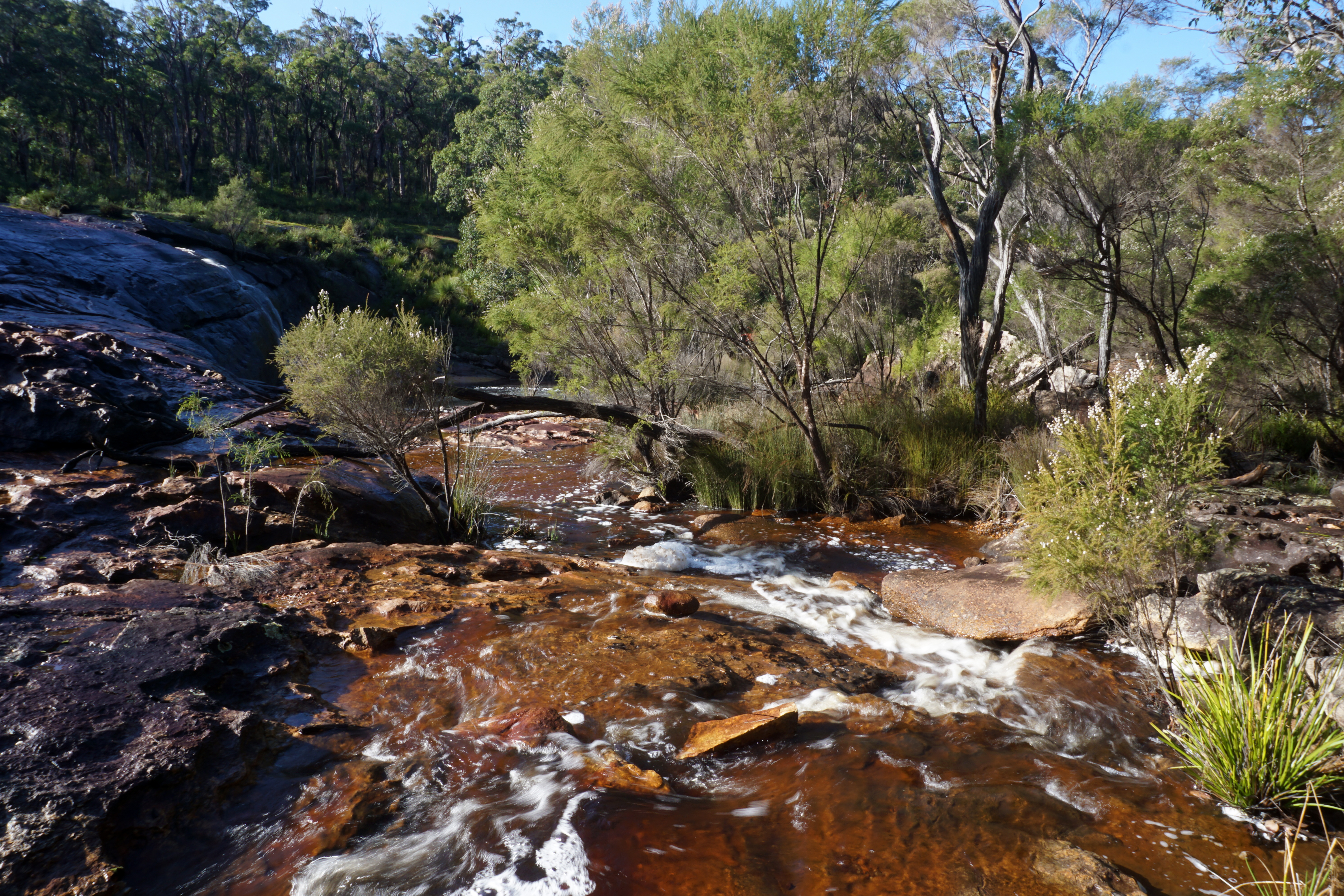
Heading through some lovely, lush Karri forest, the trail leads to a granite slab along the river with excellent views of the Frankland River. Looking upstream, the river looks calm and tranquil.

Meanwhile right in front of the granite slab is a series of rapids that were flowing rapidly at the time of my visit. This was really excellent to see and was well worth the effort of undertaking the side trip.

I spent a while here just taking in the lovely scenery and all that had happened over the day. I probably would have stayed here longer, however once it started to rain I decided it was time to get back to the hut.

With rain forecast yet again, Alissa and I set up the tent in the annex at the rear of the hut. At Yirra Kartta, a wet patch in the closed off alcove section meant we didn't set the tent up in the more sheltered corner, however with rain run off courses heading away from the hut we made use of the perfect spot to set up our very comfortable home away from home.

Needless to say, this was a really eventful day for reasons that were both intrinsic and extrinsic. Considering that this day started with a walk to the summit at Yirra Kartta, passed through interesting plains scenery and Karri forest, visited Fernhook Falls, Mt Frankland and a side trip to the Frankland River, Yirra Kartta to Kwokralup Beela is quite possibly the most intrinsically eventful day of the track, even if days like Nala Mia to Nannup and Pemberton to Northcliffe are more consistently excellent. The low energy issues did put a bit of a damper on my day at the time, but looking back over it I can see how these were more from a certain unpreparedness rather than any real issue with the trail. The lesson of the day was well worth learning however, and I would ensure a better selection of high energy snacks were with me for the rest of the trip.


0 comments:
Post a Comment