

Day four of a seven day thru-hike of the Cape to Cape Track, this relatively easy day on the track takes walkers from Prevelly to Contos. Initially heading inland before descending steeply to the Boodjidup Brook crossing, the track then follows Boodjidup and Redgate Beaches before taking walkers to the limestone cliffs at Bob's Hollow. With spectacular views of Contos Beach, this is another fantastic stretch of the Cape to Cape.
Distance: 16.4 km (one way)
Gradient: Some moderate descents and ascents throughout the length of the walk, with a very steep descent to Boodjidup Brook
Quality of Path: Largely clear and well maintained. Some uneven sections with rocky limestone surfaces.
Quality of Signage: Largely well signed, with the the Cape to Cape Track markers allowing walkers to remain on track (albeit lacking in directional information). Some lack of clarity at beach exits
Experience Required: Previous Bushwalking Experience Recommended
Time: 6 Hours
Steps: Many steps, with the 365 steps leading to Boodjidup Brook being the most notable
Best Time to Visit: Late Autumn/Early Spring
Entry Fee: No
Getting There: Prevelly can be reached on Walcliffe Rd, which branches off from Caves Rd. Contos Campground can be reached from Conto Rd, which also runs off Caves Rd.Entry Fee: No

After a long and epic third day of the Cape to Cape, Alissa woke up on the Tuesday morning feeling that something was not right with her back. Alissa's lower back has been quite a cause for concern as she's pulled her back out on multiple occasions over the last few years. Last year we had to postpone our planned Balingup to Pemberton Bibbulmun Track walk from July to September due to her being in so much pain she could barely walk, and it looked like disaster was about to strike again at a most inopportune time.
Trying to assess the situation, I asked Alissa how bad it was and she said that the feeling was like how it feels before it gets pulled out, but that she was scared about what could happen if she pushed it too far. Leaning more towards cautious optimism, I noted that we only had 16.4 kilometres to walk today, were not in a rush so could take our time and that I was prepared to carry some of her gear. Having Telstra phone coverage meant I could probably get signal at Contos and call for our friends in Margaret River to pick Alissa up if it was really bad. Feeling emotionally compromised due to her fear of injury, Alissa had a quick chat with her mother as a neutral party before deciding that she would continue onwards given the easier days ahead, but that she'd continue to monitor the situation.

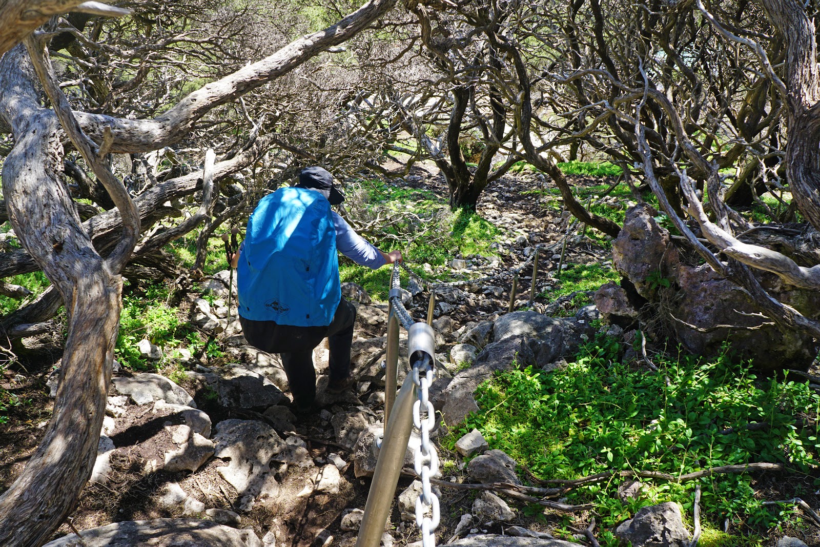
After checking out of our room, Alissa and I walked through the streets of Gnarabup to rejoin the Cape to Cape Track, which was easily accessible via an unmarked vehicle track. Having walked a longer than average day yesterday, Alissa and I were now in sync with other hikers who had been a day ahead of us and we ran into a father and son walking the track just as we joined the trail. As we were taking it easy, we let them go ahead of us but we would continue to cross paths with them over the next few days. The area that the track passes through is known as Blackboy Hollow - an apt if mildly racist name given that the area is filled with some of the most massive and mature Grasstrees we've ever seen.

Looking at the map, I wasn't sure how enjoyable this inland section would be given that its mostly on sandy vehicle tracks, but I have to admit that the yellow wattle and views of rolling hills inland made for a nice change of pace. Along this stretch of the track, we also encountered something unusual - a Cape to Cape Track marker with a directional arrow beneath it! The appearance of this arrow proved to be something of a joke however, as the arrow pointed to a stretch of walk trail that branched off the vehicle track for no more than 100 metres before rejoin the vehicle track once more! Along this stretch of walk trail, Alissa and I met a middle aged guy who was also doing a thru-hike of the Cape to Cape as a self-guided assisted walk with Cape to Cape Explorer Tours - the company we were possibly going to arrange a kayak from to cross the Margaret River. Coincidentally, the solo hiker and the father we met earlier both had South African accents even though they were on completely unrelated journeys.

While the inland section through Blackboy Hollow does have worthwhile scenery, the trail's route is also a practical consideration as it crosses Boodjidup Brook at an inland bridge crossing rather than at the river mouth.

While the approach to Boodjidup Brook is initially gentle, it soon reaches the steepest descent of the whole track as a series of 365 steps plunge walkers down to the valley floor. These steps reminded Alissa and I of similarly steep descents on the Bibbulmun Track like Cardiac Hill after Blackwood campsite and the big descent on the day between West Cape Howe and Torbay. Our friend Mark from the Life of Py had warned us about these, however he had the 'pleasure' of experiencing them in the other direction. Needless to say, we were very glad to be going down the stairs and not up!


Although choked by the declared pest known as the Arum Lily, the area surrounding the Boodjidup Brook Bridge is quite beautiful, with many impressively large and mature Peppermint trees being a major highlight. A cleared grass area and bench on one side of the brook would make a perfect picnic spot, however it was far too early in the day for Alissa and I to stop for lunch.

The steepness of the brook had been a concern for Alissa when were deciding what to do about her back, however we could tell from the contour lines on the map that the ascent out of Boodjidup Brook was considerably more gentle and easy going. The reality of actually walking the track bore this out, with the gentle terrain running alongside the brook towards the ocean.

Just before reaching the mouth of the brook, the track provides an excellent viewpoint from which to view the gently flowing water as it snakes it way to the beach. According to the guidebook, Boodjidup Brook is deep and fast flowing in winter, however at the time of our visit it would have been very easy to have crossed the mouth or the wide shallow stretch pictured above.

After reaching the brook's mouth, the Cape to Cape runs along Boodjidup Beach. This was a bit of a sand slog, with the soft sand and windy conditions making us work for our kilometres. Alissa and I literally walked in the footprints of others to give us a bit of assistance, and it was interesting looking at the different gaits of each of the individuals.
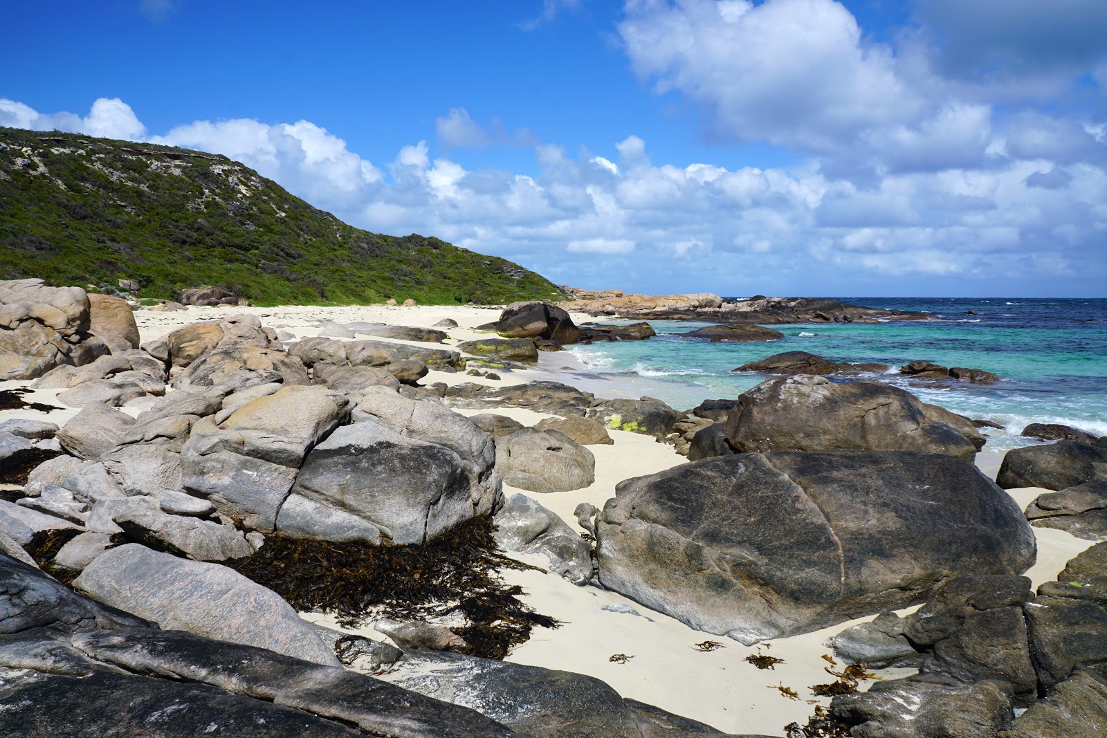
A number of beautiful granite boulders line the southern end of the beach, culminating in a small rocky headland that separates Boodjidup and Redgate Beaches.

Near the end of the beach, Alissa and I ran into a large group of adults and primary school aged children who were walking the Cape to Cape. They apparently were walking in two groups - one heading north and one heading south - and doing a car shuffle by swapping keys as they passed each other, and then driving back to a base camp for the evening. This seemed like a really fantastic way of doing the track as a family, and would be something Alissa and I would consider doing if we were to do the Cape to Cape with children.

After rounding the granite headland, the trail descends to Redgate Beach a popular if potentially dangerous surfing beach due to the number of permanent and seasonal rips. These dangers were definitely not enough to dissuade surfers and fishermen on the rocks, and this was one of the busier beaches we would encounter over our entire trip.

Having experienced the much more difficult crossing at Wilyabrup Brook and Margaret River, the ankle deep Calgardup Brook was little more than an easy wade.

At the other end of the beach, the trail exits through a thicket of tea trees that would serve as an awesome alternative stealth campsite to consider for those who don't mind the lack of toilet and water facilities, and we would meet a couple of northbound hikers later in the day who suggested they were aiming for this spot as their campsite for the night. Disappointingly however, there were clear signs that people had created campfires in the thicket even though they are banned throughout Leeuwin-Naturaliste National Park due to the highly flammable nature of the coastal heath.

From the tea tree thickets, the track rises up a series of vehicle tracks. This was one of the less exciting parts of the day, but what it was leading to was spectacular enough that the pay off was worth it.

Coming out of the tunnel of heath, Alissa and I found ourselves heading towards a stunning coastline of low granite headlands beneath high limestone cliffs.
Shortly after reaching the cliff's edge, the trail heads down a steep descent aided by a chain. The descent is surprisingly rough considering the usually safety conscious nature of trails in Western Australia, however this added a fun, adventurous quality to the day that I really enjoyed.

Heading along the bottom of the limestone cliffs, the trail begins its ascent once more as it reaches Bob's Grotto.
Bob's Grotto along the Cape to Cape Track - Spherical Image - RICOH THETA
Named with the same typically Australian irreverence that gave us Mt Bruce, Mt Sheila and the Big Hole in Deua National Park in New South Wales, Bob's Grotto is a small cave on the side of the cliffs and is one of the highlight's of the day's walk. The surrounding Bob's Hollow area is considered one of the best sports climbing crags in Western Australia, and we saw a number of bolts in the rocks that showed signs of its popularity with climbers. A spring is located nearby, however it is said to be less reliable than it used to be. We were not able to locate it, though we weren't looking very hard.

Continuing up past Bob's Grotto, the trail skirts the edge of the spectacular limestone sea cliffs, with fantastic views of the ocean below. This stretch of the walk along the cliff tops to Contos is considered by many to be the very best part of the entire Cape to Cape Track, and while there are many other sections that could just as easily lay claim to that title I have to agree that this was a thoroughly enjoyable part of the trail.


A mild drizzle set in as we were walking along the cliffs, and it resulted in me taking a lot less photos than I would have liked. The rain did however stop at a most fortuitous time, as it allowed me to capture a photo of a kangaroo foraging along the clifftop. Alissa and I had noted a distinct lack of kangaroo sightings along our walk compared to their ubiquity on the Bibbulmun Track so this was a relatively exciting moment. Although it did keep an eye on us, the kangaroo seemed unfazed by our presence and allowed me to get fairly close as it continued to graze.

The trail heads inland and away from being right along the cliff's edge. During this heath and wildflower-filled stretch, Alissa and I encountered a Dugite in the middle of the track. After tapping the ground to get it to move, the snake slithered off the track only to emerge back out onto the track again! Another round of ground tapping got the snake to finally get the message, and we continued on until we once again reached sheer cliffs as we peered down towards Contos Beach.

The view down to Contos Beach was spectacular, with its bay looking like a very inviting swimming spot. The rocky headland to the left is Cape Freycinet, named after the same famous navigator Louis de Freycinet that the Freycinet Peninsula in Tasmania is also named after. Alissa and I had always assumed that Contos campground was located right near the beach, however we were surprised to find the track head inland, across a road and finally into Contos campground.
Post from RICOH THETA. - Spherical Image - RICOH THETA
Contos Campground was recently upgraded as part of the Parks for People initiative, and as such has the high quality amenities you'd expect from a modern national park campground. Contos is huge and is divided into several sub-campgrounds, with sites suitable for everything from caravans to walk-in hikers like Alissa and I. We chose to stay in the Wanil sub-campground and were fortunate enough to have it all to ourselves.
While hanging out in the camp kitchen, Alissa and I ran into Allan and Adrian. They had started much earlier than us and had decided to give themselves a head start the next day by camping at the smaller Point Rd campground which is a further 1.5 kilometres south. Point Rd is a much more rudimentary setup without tank water, and they came back to Contos to fill up from the tap in the camp kitchen. We spent some time chatting with them and talking about hiking in Western Australia and beyond, and I gave some recommendations to Adrian for trails he could do in Tasmania. After a round of Cup A Soups we bid them farewell as they returned to Point Rd.
Although the day started with the potential disaster of Alissa having to pull out due to her back, Prevelly to Contos ended up being another excellent day of walking on the Cape to Cape Track that was relatively easy given that we were able to do the steepest part of the walk as a descent and the considerably more manageable 16.4 kilometres. While the beach walking was a mix of challenging and beautiful, the coastal cliff section from Bob's Hollow to Contos Campground definitely stole the show as a justifiably celebrated highlight, and it was nice to end the day at quite a luxe campsite compared to the somewhat spartan Moses Rock. All in all, this a good day that serves as a nice transition from the more granite-dominated walking in the north to the beach, inland walking and limestone-centric formations more common in the south.


0 comments:
Post a Comment