

Day three of a seven day thru-hike of the Cape to Cape Track, this long 34.4 kilometre day links Moses Rock to Prevelly via Gracetown and Ellensbrook. Passing by the beautiful Wilyabrup Cliffs and granite-dominated coastline leading to Gracetown, the track heads inland to the historic Ellensbrook Homestead and Meekadarabee Cave. Crossing Wilyabrup Brook and the mouth of the Margaret River itself, this is one of the track's most challenging and spectacular days.
Distance: 34.4 km (one way)
Gradient: Some moderate descents and ascents throughout the length of the walk
Quality of Path: Largely clear and well maintained. Some uneven sections with rocky limestone surfaces. Some potentially challenging river/brook crossing.
Quality of Signage: Largely well signed, with the the Cape to Cape Track markers allowing walkers to remain on track (albeit lacking in directional information). Some lack of clarity at beach exits
Experience Required: Previous Bushwalking Experience Recommended
Time: 10-11 Hours, including lunch
Steps: Many steps, especially leading to and from beaches and steep stairs near Wilyabrup Cliffs
Best Time to Visit: Late Autumn/Early Spring
Entry Fee: No
Getting There: No direct access to Moses Rock campsite. Prevelly can be reached on Walcliffe Rd, which branches off from Caves Rd. Entry Fee: No

When planning a Cape to Cape Track hike over seven days and not using car pickup points to get on and off the track or stealth camping, it is almost inevitable that you'll have to have one long day of walking. Many hikers opt to walk from Hamelin Bay straight through to Cape Leeuwin for a 27 kilometre final day (with a lot of beach walking), while John Chapman's itinerary suggests making the long day from Ellensbrook to Contos campgrounds for a 29.5 kilometre fourth day. Right up until a week before the walk, our plan had been to do Ellensbrook to Contos as per Chapman's itinerary, however the possibility of getting a room at Margarets Beach Resort in Prevelly allowed me to present an option to Alissa - we could instead walk about 33 kilometres on day 3 to finish at a hotel instead, thus giving us motivation and a reward for the end of the day. Although the long kilometres were obviously a bit of a concern for Alissa, the option for a hot shower or bath and a cooked meal was definitely appealing, and we ultimately made a last minute change to our itinerary.
Waking up at Moses Rock campsite on day 3 brought about yet another last minute change to our itinerary; the forecast rain had been no where near as bad as we had thought it was going to be, and we decided we would risk crossing the Margaret Rivermouth at Prevelly rather than take the diversion. With a very long day ahead of us, Alissa and I got up before sunrise and were on our way by 6:40 am. With dark clouds still on the horizon, the early morning walk along the coastal cliffs was particularly moody and dramatic.

From the cliffs, the track descends to Wilyabrup Beach and our first brook/river crossing of the day. Wilyabrup Brook is one of the more epic looking water crossings of the track, with large granite boulders that can be used as stepping stones. The Cape to Cape Track Guidebook features a photo of an adventurous walker hopping from rock to rock, and this was my initial plan when we came to the crossing. Upon further investigation, we realised that the rocks at the far end of the brook were submerged and with water flowing fairly fast over them, and we decided it would be safer to just wade through.

Although the water was fairly fast flowing, it was little more than shin deep and was another fairly easy crossing. Beyond the brook, the Cape to Cape continues along the beach before rising up into the dunes beyond.

The walk continues beyond the dunes onto a 4WD track that ascends to follow the cliffs, eventually joining onto purpose built single file walking trail.

As we continued up and across the coastal ridge, Alissa and I were excited to see the Wilyabrup Cliffs were only a short distance away.

This section, passing through the coastal heath while looking at the granite formations of the coast below, is one of my favourite stretches of the track, with beautiful wildflowers and rugged scenery making for very enjoyable walking. Although very different to the glacially carved mountains of the Overland Track, there was something about the combination of low heath and rugged beauty that made me think of our time in Tasmania. Although there were some sections closer to Wilyabrup Beach where farmland has encroached right up the cliffs, it is actually quite impressive how much of the original vegetation is still in place and how wild an experience the track offers is such a developed area.

The track descends to cross Biljedup Brook, a small stream just before the Wilyabrup Cliffs. Being able to get so close to sheer granite-gneiss cliffs is a real treat, and while much shorter than the massive cliffs in Torndirrup or West Cape Howe National Parks near Albany, the fact you can stand at the bottom of the cliffs is a rare privilege.
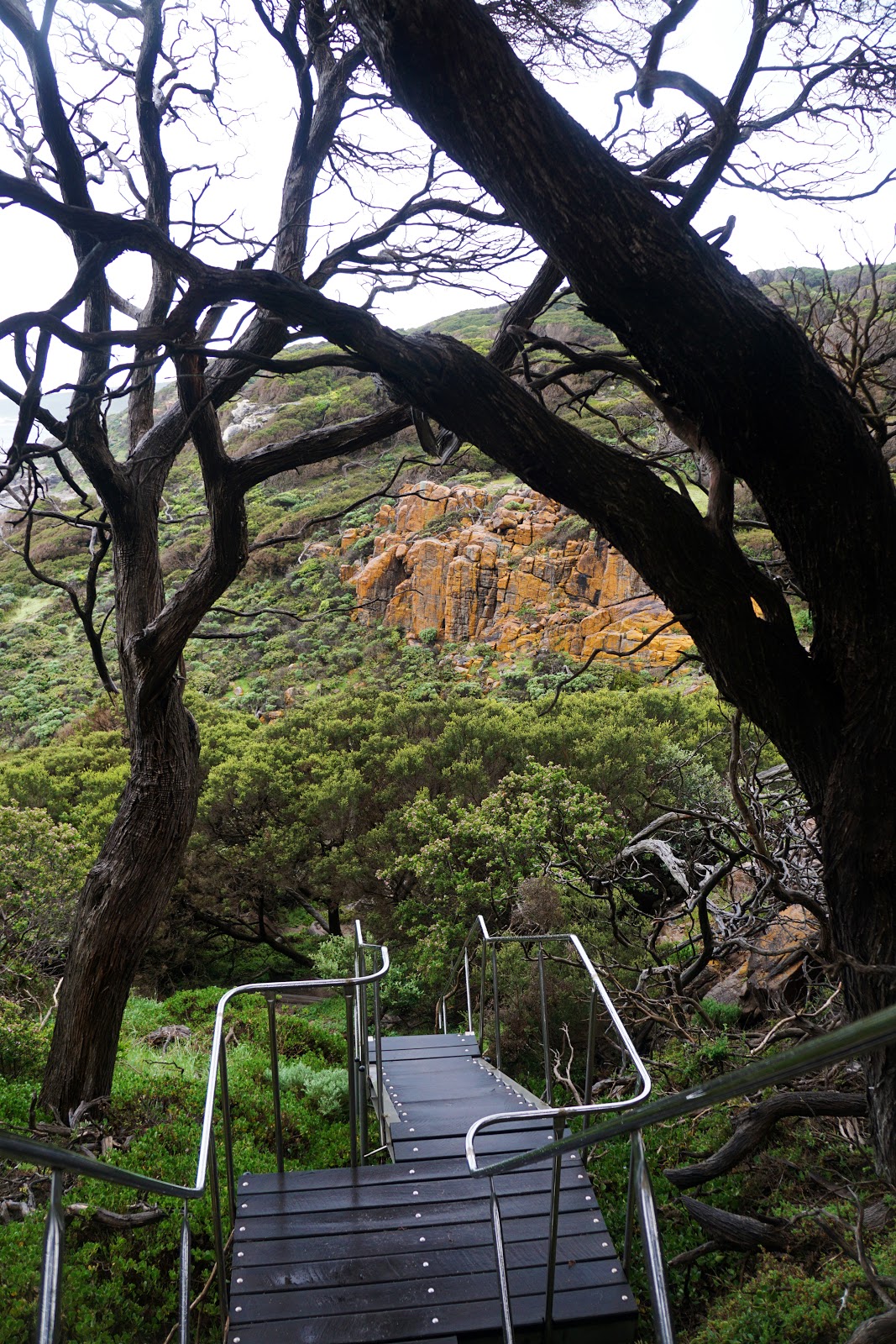
Leading back up the other side of Biljedup Brook's valley, the track rises up a fairly impressive set of stairs to head along the top of the Wilyabrup Cliffs. This area is very popular with rock climbers, however none were out on our day of walking.

Beyond the Wilyabrup Sea Cliffs, the track continues along limestone coastal cliffs that are quite similar to those seen earlier in the day near Moses Rock campsite.

The track passes several different sets of beach access steps along the cliff top before descending to Cullens Beach via the steep stairs pictured above.

Once at the beach, we could see that there had been significant sand movement along the dunes, with the Cape to Cape Track signage almost submerged in the sand. From here the track continues behind the beach in the dunes before rising up and following an old vehicle track.

As the vehicle track gradually descends on its way to Gracetown, the Cape to Cape Track passes through one of the most beautiful and rugged stretches of the track.

Although lower than the massive granitic gneiss formations like Sugarloaf Rock and Canal Rocks that were highlights of day one and day two respectively, the beauty of this stretch of coastline is that it was a sustained wonderland of rugged granite formations. Although we had to really motor given our long kilometres for the day, it was hard not to stop and take photos constantly.

The track crosses two brooks over this stretch of coast, with the tannin-stained Miamup Brook being the most memorable given that most of the brooks along the track are much clearer.

Leaving the 4WD track, the trail head along purpose built walk tracks just behind the rocky coastline. While the weather and swells were quite mild on the day of walking, I can imagine this stretch of the coast being quite wild and spectacular during stormy weather, and reminded me a lot of the Bibbulmun Track between Rame Head and Peaceful Bay.

Continuing along the trail, the granite boulders become larger and more impressive. Given that all the brook crossings are named and marked on the map, the appearance of a beautiful stream crossing and waterfall over the rocks was a pleasant and totally unexpected surprise.

Beyond the waterfall stream crossing, the track rises up through tea tree thickets to a car park at North Point. Along the ascent, walkers are able to look back across the coast and see all the way to the start of the day's kilometres at Moses Rock. This is one of the things Alissa and I find quite enjoyable about coastal walks - being able to see just how far you've come can give you a real sense of achievement.

Looking southwards, Alissa and I could see Gracetown and the landmark that is its boat ramp. The trail at this point was somewhat vague, and we followed a slightly overgrown track down the hill to the boat ramp and then continued along the beach to town.

The way along the beach is blocked by a series of granite outcrops, and while we could have easily walked around on the road, I decided that a scramble over the rocks was called for. Once we had cleared the rocks, Alissa and I only had a few hundred metres to walk into town and stopped into Gracie's General Store for an early lunch. Alissa and I had the Pork and Stilton Pie and the Breakfast Pie respectively, and I can thoroughly recommend the food and coffee as being legitimately excellent. The pies are less the classic Aussie bakery pie and more like British pork pies, and the pastry is particularly excellent. A lot of their pies are actually made in-house, while some of the cakes and slices on offer are made by Cavalcade Desserts, a business own and operated by our talented friend Nadia.

Moses Rock to Gracetown Boat Ramp had been 10.5 kilometres and was our first checkpoint for the day, and after lunch we set out to complete our next subsection of the day's kilometres - the 9 kilometres to Ellensbrook campsite. On our way out of town, the Cape to Cape passes by a lookout memorial for the victims of the Gracetown Tragedy - a horrendous incident in 1996 during which the cliffs collapsed and killed a number of students and teachers. Leading up our Cape to Cape walk, I had told Alissa that I'd definitely been to Gracetown before but could not remember when. Seeing the memorial, it all came together - just two years before the cliff collapse, I had been on holiday with my parents and there is a photo of my Dad and I standing under a limestone overhang in that very location. It is crazy to think those cliffs were going to collapse at any time, and it could well have been my Dad and I who could have been killed.

After leaving the lookout, the track passes through a relatively barren moonscape. Where most of the coastal cliffs feature dense and thriving coastal heath, this stretch of the track featured large expanses of open ground with sparser vegetation. This moonscape only lasted for less than a kilometre, but it provided an interesting and unique change of pace.

Leaving the moonscape behind, the track follows a series of coastal cliffs for much of the way to Ellensbrook, providing grand views of the ocean below. The large skeletal branches of dead heath stood as signs that this area had been badly burnt by bushfire in the recent past, however the heath had recovered with such remarkable resilience that it was barely noticeable. While very enjoyable, the scenery does get a bit samey, and as the track descended to a small lookout point, Alissa and I got out the guidebook to double check where we were. As luck would have it, two guys with extremely friendly Staffordshire Bull Terriers rocked up at the lookout not long after we arrived and were able to confirm that we were not far from Ellensbrook. More importantly, they had been at the Margaret River mouth earlier than morning and said it was no more than thigh deep and easy enough to cross. This was good to know as it confirmed that we would not have to take the detour.

At Ellensbrook, the Cape to Cape Track takes a sharp turn inland. A number of hikers in the Cape to Cape Track group page on Facebook had suggested that its possible to skip the inland section heading to and from Ellensbrook and that the coastal views are excellent, however Alissa and I were keen to keep to the track at this point and see what the inland section had to offer.

Although closed for maintenance, the Cape to Cape Track passes by Ellensbrook Homestead - a National Trust listed building that was home to members of the Bussell family from the late 1850s onwards. Many of the region's towns and landmarks are named after the Bussells; Busselton is the most obvious, but Gracetown and Ellenbrook itself were named after the pioneering women of the Bussell family.

From the homestead, the track continues along sealed footpaths to Meekadarabee Falls and Cave, and serves as a strong reminder of the rich indigenous history of the area. In the local Noongar language, Meekadarabee translates rather poetically to 'the bathing place of the moon', and while the falls are not overly exciting, the cave - with Ellen Brook literally flowing right through it - is one of the lesser known gems of the Margaret River region. A story book made from durable materials is located near the falls containing a piece of indigenous folklore about the cave. In our experience, Alissa and I have found that Western Australia is generally better than other Australian states we've visited at providing interpretive panels that allow visitors to engage with indigenous history and culture, and I would have to say this story book is one of the best I've seen.

Beyond the cave, the track reaches Ellensbrook Campsite. The toilet and water tank are right next to the trail, with the actual tent sites along a side trail to the left of the track. As we were not going to be staying the night here, Alissa and I did not explore the tent sites and instead chose to have a short lunch break sitting on a wooden stump by the water tanks. As we were eating lunch, Allan and Adrian caught up to us. They had also planned to cross the Margaret River mouth due to the lack of heavy rains and were pleased to hear that the two guys we had met earlier had confirmed that it was safe to cross. Although we all departed Ellensbrook at the same time, my painful left foot meant I simply could not keep up with Allan and Adrian, and we parted ways for the time being.

Although the initial stretch of track from Ellensbrook campsite was quite lovely due to the unexpected appearance of Karri trees, the trail joins onto a 4WD track that proved to be something of a dull corridor with little in the way of views. While this was an admittedly boring part of the day, it was at least mercifully short, and brought us out onto a wildflower-covered ridge.

The fields of yellow, blue and purple wildflowers were a definite treat, as were the appearance of some tall limestone columns that bore a strong resemblance to those found in the famous Pinnacles Desert of Nambung National Park.

Reaching a junction in the trail, Alissa and I reached the point where the winter diversion branches off from the main track. While walking north to south on the Cape to Cape Track is generally seen as the traditional direction to walk the track, northbound hikers have the benefit of having a short distance to travel between the Margaret River mouth and where the winter diversion rejoins the trail. Southbound hikers on the other hand really have to commit to the river crossing at the diversion point or risk a very long detour back to this point and around the winter diversion if the river was flowing too fast or too high to safely make it across. This was something of a point of no return for Alissa and I, however the intel that we had been given made us confident that we could continue onwards without needing to double back.

Continuing along the limestone ridge, Alissa and I passed through an area that looked like it had been seriously burnt by bushfires in previous years - worse even that what we had seen earlier in the day near Gracetown. The amazing regenerative abilities of coastal heath were again on full display however, and the skeletal remains of burnt out trees were balanced out by some lovely wildlfower blooms.

The track descends to the beach and follows a sandy vehicle track to a limestone formation known as Joey's Nose due to its similarity in shape to a kangaroo's nose.

After passing Joey's Nose, Alissa and I caught up to Allan and Adrian who were assisting a couple who had gotten their car bogged in the sand. Allan had the situation under control, and encouraged us to keep going.

Beyond Joey's Nose, the track passes through some lovely boulder-filled white sand beaches. The fine white sand was similar to what we had encountered at Fitzgerald River National Park when we walked the Mamang Trail, and it provided for some relatively firm and enjoyable beach walking. In the distance Alissa and I could make out Cape Mentelle, meaning we were now not far from the river mouth.

Continuing along the beach, the granite boulders eventually disappeared and gave way to more geologically recent limestone-dominated formations. At the end of the beach, walkers have to climb up to the top of a limestone shelf as they continue onwards to Cape Mentelle.

Along the rock shelf, Alissa and encountered a pair of Pied Oystercatchers. I had noticed that the birds were not overly shy and were not flying away, so I decided to try and get a close up photo. As one started to aggressively call out and flew at me, it dawned on us why they were not moving - they must have been a breeding pair guarding their eggs or young, and Alissa and I promptly continued on our way.

Descending the rock shelf and continuing along another stretch of beach, the Cape to Cape reaches another of it slightly unclear beach exits. Checking the guidebook, Alissa and I confirmed that we had to follow a vehicle track off the beach rather taking a flight of stairs up to the point of Cape Mentelle itself.

The vehicle track leads to some excellent views to a series of secluded coves below sheer cliff tops, and it reminded us of the coastline in Port Campbell National Park near the Twelve Apostles and Loch Ard Gorge.

Clearing the cape, Prevelly came into view. To the left we could make out the Margaret River, however the river mouth was still obscured by the low dunes just before the beach.

Reaching the beach, Alissa and I were pretty confident that the river was not flowing fast enough to be a problem and we timed our crossing between the waves. Although choppy, walking out to the ocean side meant we were never more than knee deep and I even felt confident enough to stop halfway and take a photo as we were crossing. I was glad to add this to our list of successful river crossings, having crosses the Torbay and Murray Rivers on the Bibbulmun Track and the Fitzgerald River on the Mamang Trail.

After crossing the river, we saw Allan and Adrian had caught up to us and were preparing for their own crossing. Seeing them checking out the deep and narrow section of the river, we advised that it would be easier to cross at the ocean side. Allan, who'd had less positive experiences with river crossings than Alissa and I as he'd fallen into a river on the Australia Alps Walking Track, was particularly cautious, and did the crossing arm in arm with Adrian.

From the river mouth, the Cape to Cape runs up along the river and continues along the hills behind Prevelly. As we were staying at Margarets Beach Resort just south of Prevelly in the locality of Gnarabup, Alissa and I found our own way there along the coast rather than following the official route that skirts around town. While I'm usually a stickler for following the official route 100%, I felt like we'd already walked more than enough kilometres today and that it was in keeping with the spirit of the Cape to Cape Track guidebook which regularly offers alternatives for those afraid of exposed cliff sections and such flexible advice as 'follow either the beach or road'.
The last few kilometres walking along paved sidewalks to Margarets Beach Resort were not objectively tough, however it was still 2.9 kilometres from the river mouth to our accommodation and we were definitely getting very fatigued by the end of it. Checking in, we were very glad to take off our boots and have showers, and were happy to discover the room also had laundry and dryer facilities to wash all our dirty clothes.

As good as it was to get clean, a major highlight of staying at Margarets Beach Resort is the in-house restaurant named The Common. Not having much in the way of nice clothes and not feeling like sitting down in the restaurant itself, it was great to know that we could get takeaway. Alissa and I thoroughly recommend the burgers, with their fluffy brioche buns and excellent fillings - the perfect meal for the end a long and challenging day of walking.
Moses Rock to Prevelly was the longest day of our Cape to Cape Track thru-hike, and although I've walked 60 kilometres in a day before with a small day pack, our final count of 34.4 kilometres was definitely the longest distance Alissa and I have ever walked with full packs. Although we were pretty fatigued by the end of the day, Alissa and I agreed that being able to split the walk into three sections - Moses Rock to Gracetown, Gracetown to Ellensbrook and Ellensbrook to Prevelly - made it quite manageable in terms of mental stamina, and that the excellent, beautiful scenery over the whole day kept us inspired to keep pushing. If we were to do this again, I would probably consider a different split of the kilometres to make it easier, however with highlights such as the Wilyabrup Cliffs, the granite coast near Gracetown, Meekadarabee Cave and the memorable brook and river crossings, Alissa and I agreed that this was one of our favourite days of the entire track.


Excellent write up, great pics too ! Thank you !
ReplyDelete