

One of Australia's finest day walks, the Coomera Circuit takes walkers through World Heritage-listed subtropical rainforests in Lamington National Park. Starting at Binna Burra, the trail passes through a landscape filled with one stunning waterfall after as it follows the Coomera River and its tributaries. Culminating in the massive Coomera Falls, this is arguably the pick of the bunch for walks in South East Queensland
Distance: 18 km ('tadpole' loop)
Gradient: A mix of relatively level walking and moderate descents and ascents
Quality of Path: Generally clear and well maintained trail with constructed steps and railings in places
Quality of Signage: Clear and easy to follow trailhead, with markers along the way and clearly marked trail junctions
Experience Required: Some Bushwalking Experience Recommended
Time: 5-7 Hours
Steps: Many steps in place, particularly leading up and down from the waterfalls
Best Time to Visit: After decent rains
Best Time to Visit: After decent rains
Entry Fee: No
Getting There: The trail starts at the end of Binna Burra Rd near Binna Burra Lodge. 
With Alissa back on the Gold Coast and the weather having lined up for perfectly clear skies, Simon, Zach, Alissa and I headed out to Lamington National Park to complete my number one most highly anticipated walk in South East Queensland - the Coomera Circuit. As with the Grampians, Lamington was one of those national parks I'd learned about from an old Steve Parish landscape photography book and had wanted to visit for over 20 years. Furthermore, with the Coomera Circuit repeatedly listed as one of the best day walks in Australia, my expectations were pretty high, and I was hoping for a South East Queensland equivalent to an all-time favourite like the Grand Canyon Walk in the Blue Mountains.

Starting at Binna Burra, the Coomera Circuit starts by following the Border Track. the Border Track is a pleasant section of rainforest walking that links Binna Burra to a surprisingly large number of other trails in the area. This is pretty clever and economical trail design, and allows walkers to use the Border Track to complete several different circuit walks.

About two kilometres into the walk, the four of us reached the junction with the Coomera Circuit. The informative trailhead in the car park suggested that hikers should follow the Coomera Circuit in an anti-clockwise direction, however upon closer inspection this seemed like a less inspiring way of complete the trail as it passes by all the waterfalls on the first half and then has less eventful rainforest on the way back to the car. As a result, we ignored the trail junction turning off onto the Comera Circuit on the right and continued left along the Border Track.

The walking along the Border Track was the typically beautiful subtropical rainforest common to the national parks of South East Queensland and Northern Rivers New South Wales. While lacking in grand landmarks like waterfalls or flowing creeks, the area was filled with finer details that kept the walk engaging.


While we'd seen ferns on a number of other trails in South East Queensland, the sheer size and abundance brought back memories of the Grand Canyon Walk and how beautiful Australian rainforests can be.

The highlight of the Border Track section of the walk are the views of the Woggunba Valley from the Joalah Lookout. Merely a clearing in the forest rather than a constructed lookout point, the views across the valley are excellent and an early highlight of the trail.

After a short break taking in the valley views, we continued on our way until we reached another junction in the trails. Since we were going against the general flow of the trail, there was no indication as to which way the Coomera Circuit is supposed to go, however we were able to make a fairly safe educated guess that we had to take the right turn given that the trail would eventually have to loop back to the first junction we had encountered earlier in the day.

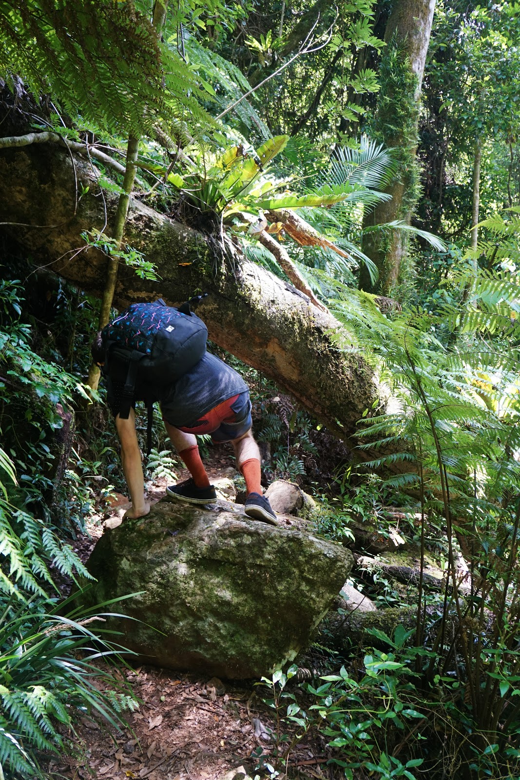
Almost immediately, the four of us entered an area of forest that was much wetter than what we had seen along the rest of the Border Track part of the walk, with moss covered boulders giving us some indication of what we could expect further along the trail.

After 10 minutes of walking past the first lot of boulders, we came to our first creek crossing at Hobwee Creek. A shallow trickle at this point of the circuit, we would encounter Hobwee Creek again further downstream.

The combination of boulders and use of rocks for the track really drove home the Grand Canyon comparisons - if you added a few sheer sided walls of sandstone, the overall feel was very similar.

While the next creek crossing was still quite shallow, this was a noticeable step up from Hobwee Creek, with small pools on either side of the track.

As we looked into the pool we spotted our first Lamington Crayfish. Having a blue tinge not unlike some Marron back home in Western Australia, these guys were certainly of a similar size to Marron and were seemingly in every waterway throughout the park.

As we continued along, we passed our first major section of creek as the trail made its way alongside Dragoon Bird Creek.

The rocky creek and abundance of moss reminded me of some of the cool creek systems that flow through the Karri forest back home, although this was a level of wet mossiness that was edging towards the rainforests in Tasmania.

While I'm usually the one to be impressed by nature's grand statements like waterfalls, mountains and canyons (pretty much everything rugged), Alissa is more likely to be looking at the finer details along a trail. It was surprising then that I was the one who pointed out this skeletal leaf to Alissa who appreciated its lace-like beauty.

Alissa made up for not initially seeing the leaf by pointing out a cluster of small fungi growing on the forest floor. The pink coloured fruit near the middle of the photo was a Lilly Pilly. I grew up with a Lilly Pilly tree in my parent's garden, but I had never seen one growing in the wild before.

Not long after passing Dragoon Bird Creek, we reached another junction in the trail. This was the first signed to explicitly point us in the direction of Coomera Falls and gave us some relief to know we were heading in the right direction.

A few hundred metres further down the trail, we encountered the first of the trail's many beautiful waterfalls as the track crossed over right near the head of the falls.

Named Goorawa Falls, this small cascading waterfall was a great first for our day's walk, and we appreciated the fact that walkers were able to get right up close to see the falls in action.

A nice feature of the Coomera Circuit is the fact that the trail regularly takes walkers to multiple viewpoints of the same waterfall, with the trail allowing walkers to actually get onto the trail further downstream of Goorawa Falls.

Continuing on along the circuit, the trail crosses Dragoon Bird Creek once again before leading to one of the trail's most stunning waterfalls.

Neerigomindalala Falls may have been a small waterfall compared to giants like Twin Falls in Springbrook National Park and Minyon Falls south of the border in Nightcap, however its sheltered position in the forest and the small pool below made it one of the most gorgeous waterfalls we'd encountered while living in South East Queensland. Always keen to hop in for a swim, Simon initially thought this would be a great place for a dip until he realised how freezing cold the water was.
Neerigomindalala Falls in Lamington National Park - Spherical Image - RICOH THETA

Continuing on, we followed the creek as it made its way to the Coomera River. Even when not flowing down a true waterfall, the cascades along made for incredible beautiful and scenic walking and would be major highlights on a lesser trail.

As we continued downstream, I came across a Lamington Crayfish going for a casual stroll along the trail. Upon seeing me, the crayfish backed off defensively and I chose to walk around on another side trail to avoid scaring him. Simon walked right passed him and experienced their somewhat fearsome reputation for defending themselves as the crayfish used its pincers defensively to ward Simon off.

Just around the corner from our crayfish encounter, the four of us crossed Bower Bird Creek once again.

One of our favourite part of the Overland Track in Tasmania was the overnight side trip to Pine Valley, and the thick, lush moss of the area was one of the things I most remember of the beautiful forests in that area. While far warmer than Tasmania, the moss in some places of the trail had a similarly shaggy appearance to what we encountered in Pine Valley and hinted at the shared Gondwanan Heritage.

15 minutes after Neerigomindalala Falls, we reached yet another beautiful waterfall. Chigigunya Falls was a very different, multi-layered affair compared to Neerigomindalala and was just as beautiful in its own way.

While the waterfall is most easily accessed immediately to its left, I discovered a perfect vantage point immediately facing the falls.

Although not the most impressive waterfall along the trail, we decided to stop for an early lunch at Moolgoolong Cascades as the pool beneath the falls were of a decent size for Simon to swim and the large number of boulders made it a great place to sit down and take a break.

I was glad that we had planned ahead the day before as Alissa, Zach and I had bought some Banh Mis from Helensvale which made for a deliciously porky sandwich lunch.

At one point a piece of my bread had fallen off to my right, and I was shocked to discover a Lamington Crayfish right near me! The cray seemed largely unfazed by my presence, and only disappeared after taking the piece of bread and going off somewhere beneath the surface to eat.

Packing up our rubbish and continuing on after lunch, we encountered a much wider section of Hobwee Creek as we made our way across to the other side.

There were literally waterfalls everywhere along the track, with the water from Gwongarragong Falls literally flowing over the track and downstream to yet another waterfall.

Reached via a side trail Kagoonya Falls would easily by my pick as the best spot for a swim along the Coomera Circuit and in hindsight would have been the perfect spot for lunch.

With its pool of water in the open sunlight, this was finally the time for Simon and Zach to get in their swim. While still colder than the swimming holes along the Twin Falls Circuit or Minyon Falls, the somewhat deep pool was warmer than many of the others in the park. While I usually would have joined them for a swim, the bright light and the fact I forgot my neutral density filter meant I was not satisfied with the overly bright appearance of my first photos of the falls. My patience paid off as clouds eventually moved overhead and provided the perfect lighting to take the above photo of the falls in action.
After Simon and Zach dried off and I got my photo, we continued on along the trail until we reached our next side trip to the next stunning waterfall.

While we could have been experiencing waterfall fatigue by now (if that is even possible), Bahnamboola Falls was yet another very different looking waterfall.

Cascading off a sheer gorge wall, Bahnamboola Falls reminded me a lot of the waterfalls along the Mersey River on the Overland Track - albeit at a smaller scale.
Bahnamboola Falls in Lamington National Park - Spherical Image - RICOH THETA
The beautiful sheer walls and the waterfall's pool would make this another great spot for a swim if not for the fact it was so close to Kagoonya Falls.


Continuing on, we reached yet another waterfall at a main junction in the track. The waterfall pictured above is immediately below Bahnamboola Falls and Alissa -who had walked ahead while I took the 360° photo - could see us setting up the camera from this vantage point.

As we explored the area around the shallow pool near the trail junction, we were amazed by a tree that had grow precariously above a well-worn section of rock with its roots clinging onto the edge.

From the junction, a side trail heads left along the river to Nahnangoola Falls. The falls were decent enough, but were simply not as spectacular as some of the Coomera Circuit's best. A blocked of section of trail suggests that a side trail continued on along this way in the past but had since fallen into disrepair due to a previous season's landslip.

Back onto the main trail, the Coomera Circuit provided us with an alternative view of Nahnangoola Falls from the other side.

As the trail continues, the river forms a more consistent gorge-like shape, with the trail running along the rim as it looks down into the river. The trail here is at times quite narrow but is well formed enough to be easy enough to traverse.

While lacking in waterfalls, this section of the trail featured a number of spectacular river crossings, with the track passing over massive boulders to get to the other side.

Continuing on, the river flowed deeper and deeper until we reached a section of track that runs high above Coomera Gorge. These next 500 metres are narrow and lacking in safety railings, so the warning sign pictured above was entirely appropriate and very apt.

Walking along the trail, it was incredible to see multiple waterfalls just flowing into the gorge. The experience of looking down at the flowing waters was very similar to the deep slot canyons below the Grand Canyon Track in the Blue Mountains.
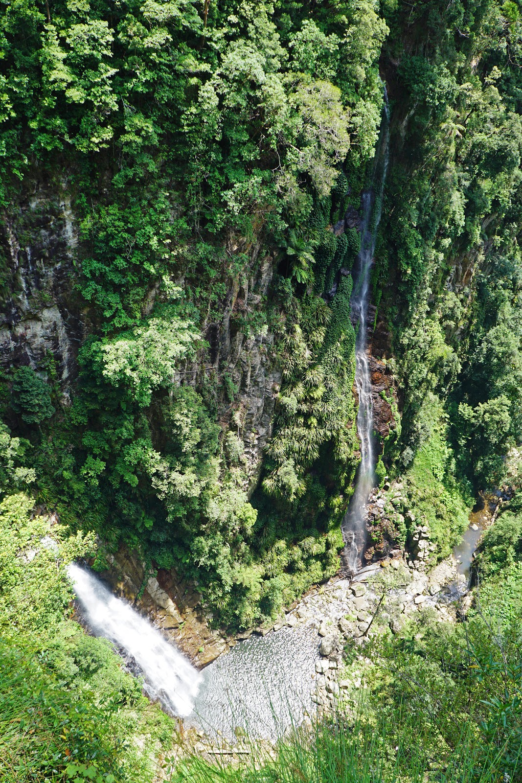
Coming to the end of the narrow section of trail, we found ourselves at the spectacular Coomera Falls Lookout where two waterfalls meet as they run into the Coomera River.

This was just and incredible sight, with the rainforest-filled gorge looking less like the Australia I'm used to coming from flat Western Australia and more like something you might expect to see in Asia or Canada.

From the falls lookout, the trail heads uphill, albeit at a very slow and relatively gentle incline. While there were a number of streams crossing the track, they were often quite dry and less spectacular than what we had encountered earlier along the trail. The trees along this stretch were a major highlight however, with several giants providing for engaging rainforest walking.

The heavily burled Eucalypts along the track reminded me a lot of the Tingles in the Valley of the Giants, and pointed to the theory that the Tingles initially evolved in Gondwana and are a relic fom another time.

After what seemed like a far longer walk than we had expected, we reached the junction with the Border Tack once again, thus completing the Coomera Circuit. From here it was another two kilometres back along the Border Track to Binna Burra and the end of our day's walking.
Every now and then you get to walk a trail in this bushwalking caper that reminds you why hiking is such a rewarding activity. It can be a spectacular coastal walk like the Bald Head Walk Trail in Albany, through Australia's tallest mountains on the Main Range Track in Kosciuszko or the the deep gorges of Weano and Hancock Gorge in Karijini National Park or the Grand Canyon in the Blue Mountains. The Coomera Circuit's seemingly endless stream of waterfalls would easily place it in that category as not only one of the finest day walks in South East Queensland, but one of the absolute best that Alissa and I have had the pleasure of walking anywhere in this country. If you only have time for one day walk in South East Queensland, make it this one - you won't regret it.


I agree Don, it's a favourite of mine too.
ReplyDeleteYes, I noticed it had a Feral Favourite tag!
DeleteWhat a brilliant write up , thx
ReplyDelete