

One of the finest all-day walks within two hours of Perth, the off-track Boyagin Rock Walk GPS Route explores the granite-dominated landscape in Boyagin Nature Reserve. Starting at Boyagin Rock, the walk passes through beautiful Wandoo Woodlands and some of the most incredible giant granite boulders on any walk in Western Australia. A thoroughly enjoyable circuit walk at the edge of the Wheatbelt.
Distance: 17 km (loop)
Gradient: Alternates between relatively easy, gentle gradients and section of very steep difficult terrain, with some scrambling required
Quality of Path: Ranges from well formed vehicle tracks, informal bush pads and completely off-track sections with no obvious path through often thick scrub. The rocky scrambles would be very slippery after rain - extra caution must be taken.
Quality of Signage: Non-existent. This walk is an unmarked route and map reading skills are essential. Route information is available from Walk GPS.
Experience Required: Previous Bushwalking Experience Required. This is a navigationally difficult walk that is highly unsuitable for all but experienced hikers who are comfortable with off-track navigation.
Time: 7-8 Hours, including lunch
Steps: Many informal steps, plus some scrambling required
Best Time to Visit: Late Winter/Mid Spring
Entry Fee: No, however access to the GPS file requires a subscription to Walk GPS.
Entry Fee: No, however access to the GPS file requires a subscription to Walk GPS.
Getting There: The trail starts from at the Boyagin Rock day use area. From Brookton Hwy, head south on York-Williams Rd and then head east on Boyagin Rd. Follow signs to Boyagin Rock via Pech Rd. Car park is located at the end

With such an outstandingly wet winter, Alissa and I have had to be strategic about what walks we do and when. A walk that was high on our list of places to check out was the Walk GPS route over Boyagin Rock, however with so much of it on granite slopes we had to cancel plans to walk it a few weeks earlier in the season. With perfect weather forecast for the second weekend of August, Alissa and I finally headed out to check out what Boyagin Nature Reserve had to offer.
Joining us for this adventure was a special guest - none other than Mark Pybus from the Life of Py. In spite of the fact that Mark has been our friend for a few years now and has been a close collaborator given Mark and I host the Real Trail Talk podcast, it might surprise readers to know that we have not walked together all that often. After singing the praises of all these Walk GPS walks Alissa and I have been doing, it seemed like the perfect opportunity for us to have a Real Trail Talk group hike for our fifth walk together.

As is common with trails in the Western Australia, Boyagin Rock features a very short walk up onto the lower slopes of the rock that passes by a small shelter featuring information about the park.

Instead of starting by following the constructed trail, the Walk GPS route immediately departs the day use area by pushing through some extremely scratchy bushes. Unlike some other Walk GPS routes, this one looked far less commonly visited, and there was no obvious bush pad that had been formed by regular use. There was nothing else we could do but push through this super scratchy scrub and hope it wouldn't last too long!

Thankfully reward for our efforts was almost immediate; after pushing through the thick scrub, Mark, Alissa and I were on the western part of Boyagin Rock looking at the main peak right in front of us. The size of this largely bald granite dome is staggering; this area is like Sullivan Rock on steroids.

Ascending the western summit, the three of us needed to negotiate the often slippery moss-covered slopes. Being adherents of Leave No Trace principles, Mark, Alissa and I did our best to avoid standing on the moss where possible as we had to pick our way through the small 'islands' of unvegetated rock between the expanses of moss.

Up on the summit of Boyagin Rock West, the three of us were able to fully appreciate the sheer size of this massive granite formation. We were probably not even two kilometres into the walk and we were already being blown away.

After reaching the summit, Alissa, Mark and I began following the GPX waypoints as they pointed us back down to the forests below.

While we were no longer on the massive formation of Boyagin Rock, we now had smaller granite formations to look forward to. Littered throughout the beautiful forests are a number of huge granite boulders that are just as worthy of exploration.

Studying the route on the ViewRanger app, the waypoints led us to a gap between the rocks and then did a weird looping that didn't initially make sense.

As we followed the route, it all became clear to us as it had us ascending the granite rocks.

The view from the rocks were once again exceptional, as they provided us with a perfect vantage point to appreciate the beauty and scale of Boyagin Rock in the distance.
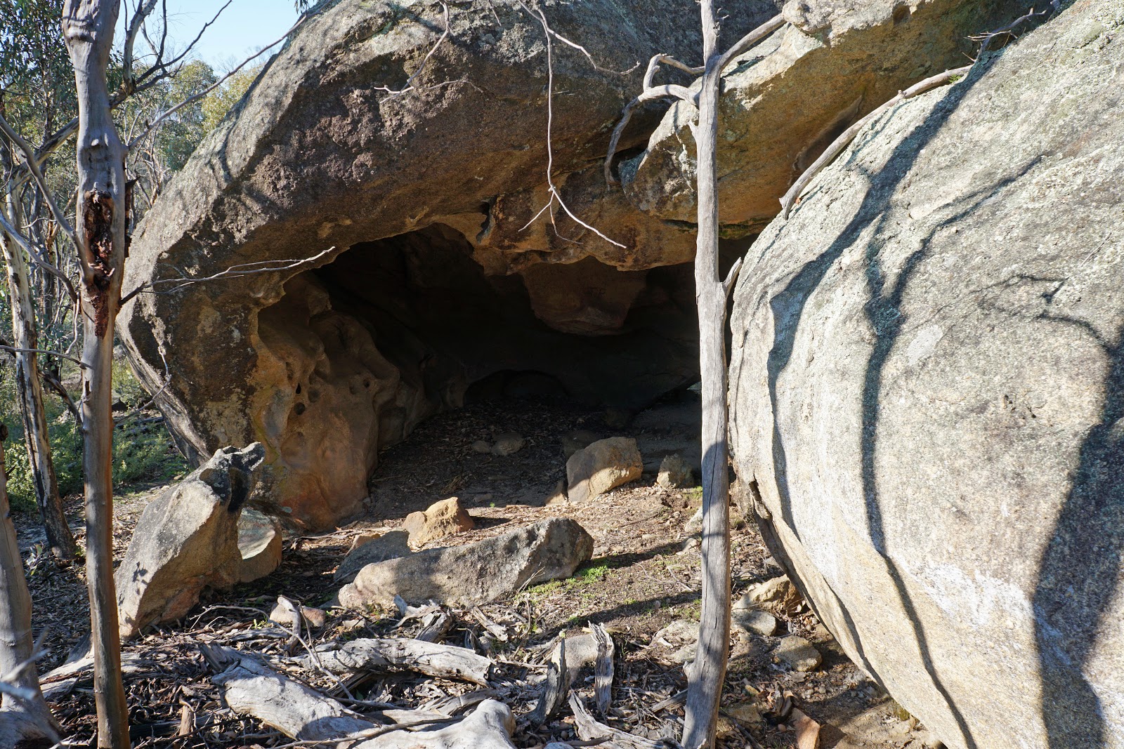
As if we needed to be even more impressed, the three of us continued along the route as it went through a small cave. Even though small compared to limestone caves of the Margaret River region, this cave was bigger than the well known but elusive cave on Mt Cooke along the Bibbulmun Track.


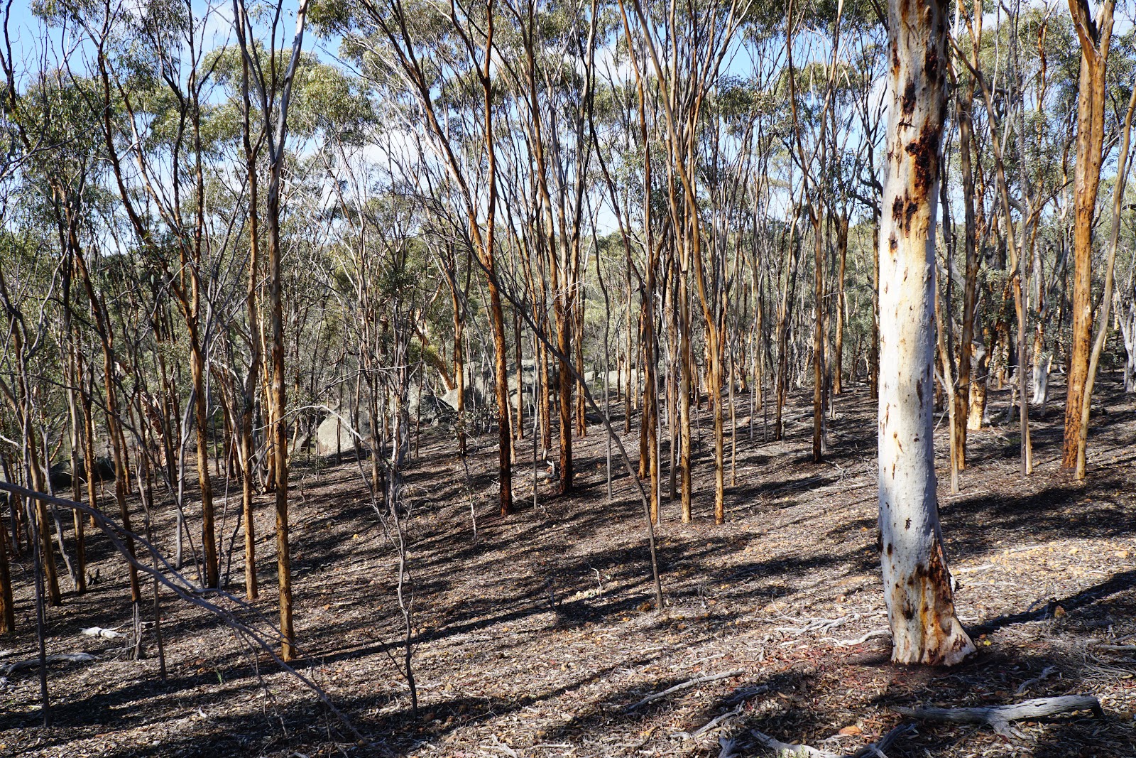
Leaving the stunning granite formations behind, Mark, Alissa and I were treated to a different kind of beautiful as we made our way through Wandoo woodlands and crossed a vehicle service track within the park.

Wandoo is to me one of the most beautiful of Eucalypts, with its smooth bark and overall appearance having far more in common with the Karri further south than their uglier Jarrah neighbours. Wandoo's open understorey is basically perfect off-track walking territory, and it was such a pleasure to be able to walk one of these off-track Walk GPS routes at something resembling a reasonable speed. With the trees glowing a magnificent golden colour, Alissa commented that this is a forest that looks like it is perpetually golden hour.

Crossing another vehicle track, the route enters a section of the park steeped in pioneer history. The first major sign of this was the remains of an old stone fireplace. With the rest of the house having completely disappeared in the intervening years, Mark, Alissa and I were left to speculate how it go there and what had happened to it and its owners.

Further evidence of human intervention in this area is a continuing series of wooden fence posts that the route follows for quite some distance. Weathered and very old, these posts are truly fascinating, and provide easy waypoints to follow given the route doesn't deviate for the fence for some time.

Walkers should not get overly complacent with all the easy fence-following navigation though, as the route eventually branches off and passes over another smaller granite slab. At this point, we could hear the sound of small aircraft flying overhead, with Mark being a bit disappointed by not being able to get a photo.

Back in the open Wandoo forest, Mark returned to looking for something he's been really hoping to sight in the wild - an echidna. While Alissa and I have been extremely fortunate when it comes to echidna sightings - have seen five between three states - Mark has never seen one in spite of being an experienced and regular bushwalker. There were plenty of signs that echidnas were about in the area as it was filled with plenty of small holes and scratchings, however we could not see any in the area around us. Given that this is prime echidna territory, I was semi-confident that it might finally yield Mark his first echidna sighting, however I added that I was not at all confident about us seeing a numbat on this walk (or ever in the wild for that matter).

Emerging out from the forest, the Walk GPS route very briefly follows an old vehicle track. Alissa was so pleased to be on an easy to follow track that she walked ahead of us and ended up missing the turn off before cutting across to meet us.

After rising up a laterite breakaway, the route once again passed over a large expanse of granite as it made its way uphill.

The route follows the edge of the breakaway before descending through more stunningly beautiful Wandoo forest.

Along the way, Alissa and Mark commented that the rock above looked like a nose with a moustache at the bottom, and we stopped to get a photo of this humourous scene.

Continuing through the forest, the three us arrived at an area filled with a large jumble of boulders everywhere. With so many boulders around, we found a spot that looked like the perfect place for a lunch stop. Looking around at the scenery of Wandoo and granite, the landscape surrounding us looked so much like a romantic colonial era painting, and I joked that I felt we should be on horseback and carrying swags to really get into the spirit of this magical place.

After lunch, the route continues as it reaches a lookout point at the end of a laterite breakaway.

Looking down at the forests and farmland below, Alissa and I were strongly reminded of the similar scenery we had encountered on the Mt Matilda Walk in Wongan Hills. Alissa had been wanting to visit the Wheatbelt again recently, so this was a perfect walk that sated her appetite for this kind of woodland walking.

From the lookout point, Mark, Alissa and I found ourselves following what looked like an overgrown but nevertheless defined bushwalking pad/walk trail through the Wandoo woodlands.

The Wandoo walking was again broken up by another expanse of granite.

This was a more substantial slab, and even featured a shallow creek flowing over the rocks. Given that this point was already relatively high up, it seemed odd that water should be flowing over the rock as it hadn't rained for a number of days, and we speculated that there either was some kind of natural reservoir upstream or some kind of ephemeral spring. While we had no need to fill up, we did think that the fact it wouldn't have passed through farmland would probably have made the water fairly safe to drink.

Leaving the granite behind, Mark, Alissa and I entered an area we referred to as the Toxic Ooze as there was a carpet of almost fluorescent green moss or grass lining the forest floor. This was really intriguing; I can't recall seeing anything like this before.

Emerging out from the forest, Alissa was very pleased when I confirmed that we would be following the vehicle track for a short distance. It is funny how I would consider road walking to be some of the dullest parts of the Bibbulmun Track, and yet these sections of road feel like a bit of a treat when off-track walking.

As the vehicle track rounds a corner, the route veers off to the right as it passes by one of the more impressive jumbles of massive boulders along the route.

These are some seriously huge boulders, and we spent a bit of time exploring the area and climbing up on the rocks. One of the rocks looks like it has a mouth as a slab has collapsed from one side. The 'mouth' formed a place for water to pool, and would be a useful emergency fill up spot during the wetter seasons.

After passing through some more excellent forest walking, the three of us arrived at one of the largest granite domes in the park.


Rising up the bare rock and then passing through a line of trees, the route took us to some expansive views of the surrounding forests below. In the distance we could see Boyagin Rock towering out from the trees. Seeing the rock gave us a great sense of how far we had travelled, as well as a bit on an indication that were heading back along the loop to the start.

From the lookout point, the trail rises up to the summit of Mt Jelcobine. The tallest point in Boyagin Nature Reserve, this laterite hill features an impressive summit cairn and lovely views of the surrounding landscape.

Following the route down from the summit, the three of us passed by some more excellent granite formations along Mt Jelcobine's slopes.


The landscape gradually changed as we continued along the route, with the Wandoo forests giving way to a more open (albeit prickly) landscape with the odd Jarrah growing overhead. Being a harsh critic of the Jarrah forest, I was pleased to note that the Jarrah here looked healthy and quite beautiful, and we all commented on the fact the trees did not have any char marks from a previous prescribed burn. We inspected the trees quite critically, and we were certain that trees looked like they had never, ever been burnt and had been allowed to become their best selves. Considering the fact it is impossible to walk for 1 minute in the Jarrah forests of the Bibbulmun Track without seeing a tree with some burn marks, this is quite an incredible feat. Mark - a lover of Jarrah forests but a critic of some of the over the top burns that have taken place in recent years - quipped that we shouldn't say where this forest is specifically as DBCA would send their people in soon enough to ruin what is a beautiful area that - surprise surprise - seems to be doing just fine without being on a crazy five year cycle of burns.

After crossing so many vehicle tracks only for the route to head right across to the other side, Alissa was extremely pleased to know we would be following a vehicle track for a sustained distance as we made our way to the north-westernmost corner of the park.

This seemed like a crazily long detour away from the main features of the park, however it all became clear to us why Dave (the creator of the Walk GPS route) took us to this remote corner of the park - it features some of the largest and most impressive granite boulders along any walk in Western Australia.

If we were impressed by the first cave we encountered, we were simply blown away by the cave in this part of the park as we audibly exclaimed 'Wow!' repeatedly as we entered.

Reminding Alissa and I of the amazing cave of Hollow Mountain along the Stapylton Amphitheatre walk in the Grampians, the cave features a passageway that allows walkers to climb up to another entrance on the other side. While Alissa was happy to go around, Mark and I had a lot of fun climbing up through the cave. Unlike the much-touted section of Weano Gorge in Karijini National Park, this cave really did require us to do a 'spider walk' up to the second exit.

The second exit leads to a boulder shelf before a drop off back to the ground below. Mark and I carefully slid our way down, and it added to the fun of this short climbing adventure.

The next bit was one of the most amazing parts of the entire walk, as we passed through a narrow entryway between two rocks as we entered a small amphitheatre/ chasm.

It is not obvious just how large the granite boulders are in the part of the park until you walk through this chasm. If you're a fan of rock formations this will definitely blow you away - especially when you consider this is a totally unknown area to most people and yet we have an oversupply of utterly boring walks in the Perth Hills that are little more than forest loops on vehicle tracks with nothing in the way of geographically interesting scenery.

Rising up a laterite breakaway, the three of us found ourselves predictably following a route from granite outcrop to granite outcrop as we made our way back to the car.


As we made our way up the increasingly large granite boulders, we could see that we were getting closer and closer to Boyagin Rock.

While we were definitely eager to get back to the car by this point, we were still finding the scenery so inspiring that we were still being stopped in our tracks. At one point we passed over a rock covered in a series of gnamma pools whichv we had to stop and investigate.

A pool further along the rock featured a more reliable water supply as a small stream flowed through the area. As a result, the pool was filled with tadpoles. Being a nature reserve, we of course left them as they were, but seeing the tadpoles did make Alissa want to take them home to see them turn into frogs. Mark commented that this walk just kept getting better and better, and approved strongly of how Dave had planned out the walk as I think doing it is the opposite direction would have been less interesting from a 'narrative' perspective.

As we left the rock behind and briefly joined a vehicle track, the three of us passed through an area teeming with sundews. A favourite of all three of us, the last time I saw such an extreme density of sundews would have been along between Sullivan Rock and Mt Cooke on the Bibbulmun Track - and even then I don't think it was quite as intense as what we saw in Boyagain Nature Reserve.

Our penultimate granite traverse of the circuit revealed that Boyagin Rock was only a short distance away.

As we made our way down the rock, the route pointed straight into a dense thicket of bushes. This was some of the slowest-going walking of the entire circuit as we had to push our way through without any obvious bush pad or open woodlands.

We were utterly relieved when the thick bush abruptly gave way to open Wandoo as the route crossed a series of ephemeral creeks.

Continuing on through the Wandoo, Mark, Alissa and I emerged near a series of large boulders at the base of Boyagin Rock. This almost felt like a massive hand waving us farewell after we had enjoyed so many of these boulders over the course of the walk.

The only thing left for us to do was to summit the main peak of Boyagin Rock itself.

This is a somewhat steep and continuous climb that I can imagine would be treacherous in wetter weather. The overall feel of climbing the dome was somewhere between Sullivan Rock and Mt Chance on the Bibbulmun Track, and Mt Lindsey near Denmark. Overall, I would consider this to be even better than all of those.

From the summit, we were privy to spectacular views across the landscape towards other part of Boyagin Rock we had climbed at the start of the walk.

On the descent, Alissa pointed out where the car was. It was only a short distance away, but we were separated by a small chasm that split the upper part of Boyagin Rock from its base. At this point we should have been paying more attention to the Walk GPS route as it veered left before ascending; instead, Mark, Alissa and I found ourselves taking a somewhat slippery slope right to the vegetated chasm and then then having to bush bash to the other side.

Needless to say, we were pretty relieved when we found ourselves on the short walk trail as it led us back to the car. I had hoped that fate would shine down on Mark and that we would see an echidna at the car park, but it was not to be. Fate would however give us an even better prize; as we drove out on the road from the park, I hit my brakes hard as I saw a creature on the road. All three were delighted when we realised it was a numbat! What a perfect way to cap off a truly great walk.
This has been our third Walk GPS walk in a row and our fifth overall, and I have to say that this route was the best of them all so far, and a masterpiece of a walk from start to finish. The route was extremely well thought out as it clearly considered what people would actually want to see in an area that is absolutely teeming with beautiful landscapes, and programmed it all together so that it simply got better and better the further along the walk we went. I don't think there is a walk with better granite scenery in the Perth region, and it would rank highly with the Nancy Peak Circuit when looking at the whole state.
If this was a marked route an a bit closer to Perth (it was a 90 minute drive from home), I can imagine this would be the most popular walk in the Perth region as it is easily better than such popular walks as the Echidna Trail in Walyunga National Park and the very overrated Eagle View Walk Trail in John Forrest National Park, and would rank up there with the walks of Paruna Wildlife Sanctuary in terms of sheer beauty.
While being on off-track walk means this should only be attempted by serious and experienced walkers, this would easily rank as one of the best walks I've done this year, and a must for those who have a love for granite rock formations and Wandoo woodlands. I absolutely loved this walk, and while you do have to pay for a Walk GPS subscription to get the GPX file, if you have similar tastes to me you will not be disappointed.


Thanks for sharing your journey with me. I briefly visited Boyagin Rock early December and found the weather to be too warm to experience a GPS walk. Will go back possibly late September October and have a crack at it then. Happy New 2019 Year. Andy H
ReplyDeleteThis is wonderful and so informative
ReplyDelete