

Day One of the classic Grose Valley overnight hike in the Blue Mountains, this day of hiking takes walkers from Mt Victoria to the campsite at Acacia Flats. Descending steeply into the valley, the walk passes by a series of spectacular waterfalls culminating in the epic Victoria Falls and then follows the stunning Grose River to the beautiful Blue Gum Forest. Finishing in the serene surrounds of Acacia Flats, this is an excellent first day
Distance: 11 km (one way)
Gradient: Steep steps into the canyon, with continual undulations over the entire day with some steep sections
Quality of Path: Rough and overgrown in places, although generally easy enough to follow and discern. Some sections where the trail seems to disappear as it passes through water. This is not a dry boot walk
Quality of Signage: Poorly signed; virtually no directional arrows over the entire route and only a handful of signs at junctions and at the trailhead
Experience Required: Bushwalking experience required
Time: 6-7 Hours
Steps: There are a lot of steps descending into the valley and a few informal steps throughout
Best Time to Visit: Autumn-Spring
Entry Fee: No
Entry Fee: No
Getting There: The walk starts at the end of Mt Victoria Rd. From Great Western Hwy (A32), head south-east on Mt Victoria Rd opposite Mt Victoria Train Station. Continue on Mt Victoria Rd until the end of the road; trailhead is located at start of the walk

Having successfully completed the Royal Coast Track, Alissa and I took the train from Otford to Central, and then onwards to the Blue Mountains. After a lovely night and dinner at the Hydro Majestic, Alissa and I left behind the luxurious trappings of the lovely hotel and made our way to the start of our next walk - the Grose Valley via Acacia Flats and Rodriguez Pass.
Given that the Hydro Majestic is conveniently located across the road from Medlow Bath station, our original plan had been to follow John Chapman's itinerary and walk the six kilometres along the vehicle track from Mt Victoria to the start of the walk trail, however six kilometres of road walking did not really appeal to Alissa and I so we decided that paying for a taxi to the Victoria Falls car park was an entirely worthwhile investment as it allowed us to start later and avoid the most boring part of the day.

Given that we'd cut the first six kilometres of boring road walking, it was only a few minutes into our walk when we reached the Victoria Falls lookout. The view from here is classic Blue Mountains - deep incised river valleys framed by sheer cliffs of sandstone towering overhead.

Given that this walk is so named because it follows the Grose Valley, Alissa and I couldn't help but peer down into the valley below and think about how much of a descent we had ahead of us.

After the lookout, the track's descent begins in earnest as it follows a series of well formed steps down into the valley.

The terrain along the descent becomes wilder and less well maintained as the trail continues, with sections that head through fairly rugged sandstone shelves along the valley walls. With its constant switchbacks, the descent reminded me a lot of my time living in Queensland, with similar scenery and switchbacks seen along the Twin Falls Circuit in Springbrook National Park.


While the descent is through dense forest, occasional natural clearings along the way provided lovely glimpses of the Blue Mountain's signature cliffs towering above.

Reaching the end of the switchback descent, a short side trip through a pocket of rainforest led to a 'cascade'. Given that when I think 'cascades' I think of the small waterfalls of the Cascades on the Lefroy Brook in Gloucester National Park, 'cascade' felt like a major undersell for what would be considered a small but lovely waterfall in most places.

Looking downstream from the falls, Odin Creek looks an awful lot like many of the beautiful creeks in Queensland, particularly looking a lot like those seen on the Coomera and Warrie Circuits.

Back on the main track, another side trip leads to the top of the falls. Looking upstream, another small waterfall could be seen feeding the creek below.

This all paled in comparison to the view downstream, with the waterfall plunging down a sheer cliff. This once again brought to mind memories of South East Queensland, where waterfalls of this type were a common sight on the Twin Falls Circuit or even the short but spectacular Sandy Creek Circuit.


From the top of the falls, the track continues its way down a series of switchbacks to the foot of the falls. The track here is alarmingly narrow, and Alissa and I joked that there is no way somewhere as risk-averse as our home state of Western Australia would allow such a narrow trail with no railing to exist with such an extreme drop off.

Reaching the foot of the falls, it became clear to Alissa and I why the cascades were just a cascade; Victoria Falls is an epic waterfall in comparison. It is not only that the waterfall features a 30 metre drop, but that its features a shelf that juts out from the cliffside. Photos unfortunately don't do this waterfall justice; you really need to stand at the foot of the falls to take it all in and experience how epic it is.

After taking our time to enjoy the waterfall, Alissa and I continued along the track. From here, the trail was a bit rougher and less clear, however it was nevertheless an obvious enough track most of the time.

A few hundred metres down from the waterfall, the trail disappeared for a moment, and it became clear to Alissa and I that we were meant to cross the creek just above a low cascade. Being afraid of slipping on wet rock, Alissa headed upstream and found an alternative route across the water while I continued across the rocks.

The water was mercifully shallow at the crossing, and I was happy to make it across the water with only a soupçon of wetness coming through my boots.

On the other side of the creek, Alissa and I went through a short section of short but constant up and downs. At one point we missed a series of steps and found ourselves clumsily sliding down a wooden log that we thought had fallen across the track, which was followed by the steps above. The experience through here brought back memories of walking to Frenchmans Cap in Tassie, particularly the section along the shores of Lake Vera before the steep climb to Barron Pass.

After the short ups and downs, the terrain settled into very gentle undulations, heading through a mix of rainforest with a fairly open understory and slightly overgrown sections through grassy Eucalypt forest. This area had been burnt by bushfire in the recent past, and while it had recovered well there were some signs of the fire's ferocity.

The valley is littered with plenty of informal campsites that have popped up over the years, however the next major landmark after Victoria Falls is undoubtedly Burra Kurain Flat. A relatively spartan campsite, there are no facilities on offer here however the scenery and dry campsites were a step up for Alissa and I compared to the somewhat lacklustre North Era campsite on the Royal Coast Track.

Regardless of quality or lack of facilities, none of this really mattered to Alissa and I as we were not staying here. The main highlight of Burra Kurain was that the campsite is where Victoria Creek meets up with the Grose River for the first time. From here on in, Alissa and I would basically be keeping the river to our left and following it all the way to our overnight campsite at Acacia Flats.

From Burra Kurain, the trail disappears for a moment. This was expected as John Chapman mentions this in his notes for the walk in Bushwalking in Australia, so we kept the river to our left and kept walking. Reading online after the walk, Alissa and I learned that walkers can cross the river via a series of rocks to the other side, and then cross again to resume the track.

Not knowing this at the time, Alissa and I simply waded through the shallow river at the shallowest point we could find, and then used a series of stepping stones to get to the track once again. Being shallow, this was easy enough, however it did mean walking in wet socks for over 9 more kilometres of the day.

The wet socks didn't really faze us at this stage; with the track initially right along the river's edge, the views of the shallow but wide river, surrounding forest and the sandstone cliffs of the Blue Mountains made for a spectacular scene. It reinforced something I'd felt when we first visited the area four years ago; those who only see the Blue Mountains from the lookouts along the cliffs are missing out on how much more amazing it is being immersed in the world below.

John Chapman's guidebook indicated that the almost 2 kilometres of track from Burra Kurain to an unnamed campsite would be partially overgrown, however while it was a bit on the rough side, it was at least easy enough to discern and follow. The walking from here for most of the rest of the day was of constantly undulating nature, with the track at times staying close to the river's edge and then at others rising up high to look down at the rocky river bed below.

Given the remote and relatively inaccessible nature of the area, there were a number of fallen trees across the track, and with only the narrowest of single file walking track there sometimes was no way to get around it other than crawling under. Nevertheless, Alissa and I could clearly see signs that while not maintained at a super manicured tourism level, large obstacles like the tree above are eventually dealt with as we could see where other fallen trees had been chainsawed through in the recent past.


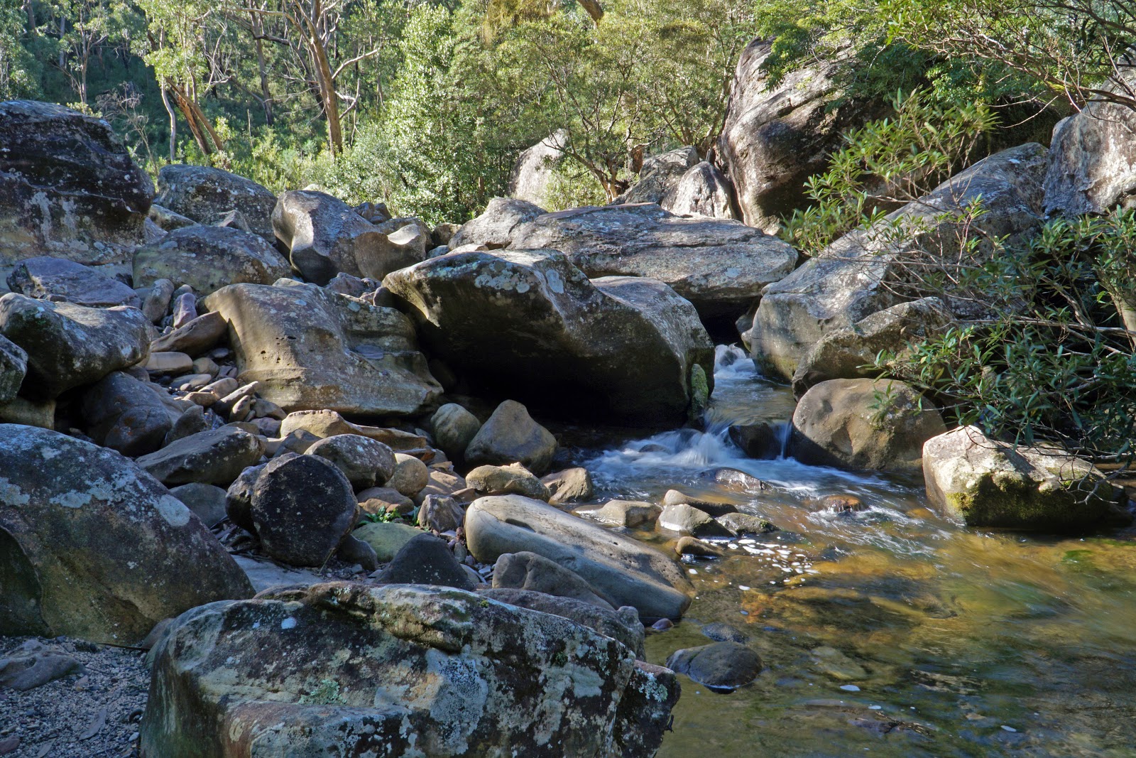
With the walking along the river falling into a bit of a pattern of undulation, it would be easy to lose track of where exactly along the Grose Valley you are - if not for the numerous creek crossings that feed into the Grose River. The first major creek crossed is known as Crayfish Creek, which features a small waterfall feeding the pool below. With some large flat rocks nearby and the lovely scenery of the creek, Alissa and I decided to stop here for lunch and to check the guidebook out for the landmarks ahead of us.

After lunch, refilling my water supply from the creek and treating it with my Steripen, Alissa and I crossed Crayfish Creek as we continued along the track.

There are some lovely views here of the Grose River, with only 500 metres separating Crayfish Creek for the next creek crossing.

Hat Hill Creek is reached not long after Crayfish Creek, and is the location recommended by John Chapman as a good spot to refill water as well as to have lunch. Having already made use of Crayfish Creek for both tasks, Alissa and I powered on as we still had almost 7 kilometres left for the day and the rough track was not the free flowing freeway that the largely boardwalked Royal Coast Track had been over the previous two days.


With a certain amount of sameness to the scenery (which was nevertheless enjoyable), the slightest vegetation change was noteworthy. Beyond Hat Hill Creek is a section of track with dense grass trees growing on either side of the track that we had to brush through to get to the other side. Used to the Western Australia variety, I was intrigued by how different they are up close. Compared to the squarish shape of the long leaves, the eastern states variety has flatter, more rectangular leaves.

With the density of the forest in the valley often precluding sustained views, it was nice to enter a relative clearing in the forest that provided us with our best views yet of the surrounding walls yet

Our next major landmark was a somewhat overgrown side trail leading to a low key campsite and a river crossing. Consulting the guidebook, we realised this was the Hungerfords Track which leads up to Pierces Pass and an alternate entry/exit point to the Grose Valley. Beyond this side track, the walking continues with a very similar mix of scenery to what we had encountered earlier; undulating terrain through slightly overgrown trail with views of the river, surrounding forests and the cliffs of the Grose Valley. All in all very scenic if somewhat repetitive.
Not long after the side track, a steep drop in the track led us down to a section running right along the river, which provided an excellent view of massive boulders all along the river bed. Initially, Alissa and thought this was a side track and I climbed back up to join the main trail only to discover that the track faded away to a dangerously steep drop off. This led us to go down to the river again with the trail appearing beyond.


This stretch by the river had a fairly open understory, which was a delight after several hours of almost continuously pushing through marginally overgrown track.

Of course, this did not last, and Alissa and I found ourselves once again pushing through dense overgrown foliage as we entered a mildly muddy section of the track.

While the overgrown nature and muddiness of the trail were not the most luxurious terrain to be walking in, the proximity to the river did mean more excellent views of the Grose River as we continued along.

A change in vegetation and a broadening of the flats got Alissa and I excited. Beyond a rough barked tree showing signs of recovery from the bushfire that went through the valley a few years ago, the smooth barked trees ahead of us made us realise we were getting close to the Blue Gum Forest. This area is sometimes known as the Little Blue Gum Forest, and we saw a number of informal campsites littered through the area.

Being fans of smooth barked Eucalypts, Alissa and I were in our element. The fact we were also nearing the end may have also played a part in our obvious elation.


At the time, Alissa and I had assumed that the Little Blue Gum Forest would essentially continue on into the true Blue Gum Forest, so we were surprised when the forest transitioned to a pocket of rainforest.

At this point of the river, the riverbed near the track was completely dry, and it made us slightly alarmed. We were keeping an eye out for Hordern Creek as John Chapman recommended it as being of better and more reliable water quality than the creeks nearer to Acacia Flat, so a dry river bed did not bode well.

Thankfully, it was a case of the river diverging into two streams, with the water flowing around the second stream on the other side of the bank and the two forks joining back together further along the river.

Only 1.7 kilometres from the Blue Gum Forest, Hordern Creek was a blink and you'll miss it affair at the time of our visit. It was so inconsequential Alissa and I initially passed it before realising the gentle trickle was our water source. While rather insipid compared to Crayfish and Hat Hill Creeks, the flow was enough that I was able to fill my my empty water bladder with more than enough water for the evening and the next day.

Beyond Hordern Gully, Alissa and I entered a section of thick vines and scrub that kept grabbing onto Alissa's hair. Alissa surmised the vines were aiming to steal her DNA to create a plant-human hybrid as part of their secret plan for world domination. While this may have been far-fetched, they did steal her trekking pole that had been strapped to her bag. Emerging out from the vines and scrub, Alissa and I were amazed by the spectacular view of the Blue Gum Forest. With its dense understory and smooth barked Eucalypts, it was every bit as beautiful as the Karri forests back home in Western Australia and particularly reminded us of the famous Boranup Forest as seen on the Cape to Cape Track.

Continuing through the forest, Alissa and I reached a trail junction. To the right, the trail branched off up to Perry's Lookdown. A steep track linking the forest to the cliffs above, this is the shortest entry point to the Blue Gum Forest and Acacia Flats. As the Long Way's Better and our goal was the much more challenging route up Rodriguez Pass, Alissa and I continued along the track to our overnight campsite at Acacia Flat.

Acacia Flat is a mere 10 minutes from the junction. While it is prohibited to camp the Blue Gum Forest itself, Acacia Flat is itself filled with towering Blue Gums and is a spectacular camping location. Given its remote location, it is perhaps unsurprising that there is no camping fee however Alissa and I agreed that it was significantly better than North Era on the Royal Coast Track which did require payment! Unlike North Era, Acacia Flats was not soggy and there actually was a clear, discernible trail to the toilet!

There are no marked out sites, however Alissa and I picked a location close enough to one of the toilets that had logs to sit on. Unfortunately, in spite of signs everywhere indicating that this is a fuel stove only location, people clearly ignore the rules and light campfires here regularly. While I understand the appeal of a fire (and would definitely understand it even more when I woke up freezing in the morning), the risk of a bushfire should not be underestimated and walkers can do their bit to ensure the Blue Gum Forest survives for future generations by using a fuel stove and packing appropriate clothing for the temperatures.

After the manicured state of the Royal Coast Track, the first day of the Grose Valley was the complete opposite, being a wild and partly overgrown track in a wilderness area that was much slower going than the boardwalks of Royal National Park. In spite of the greater challenge and rougher track, this was an excellent day of walking through a beautiful landscape of sheer cliffs, lovely forests and a charismatic river that, while somewhat samey for most of the day, was enjoyably so. The waterfalls early in the day and the Blue Gum Forest at the end made for fantastic bookmarks to a lovely day on the track, and Acacia Flats is a great, basic campsite in a beautiful location. Being a bit rougher and wilder means this is not for everyone, but experienced walkers will find a lot to savour here - before the tough climb out the next day!


Thanks for posting this one Don, I'm thinking of heading up later in the year and doing it. Cheers Kevin
ReplyDelete