

The first day of an overnight hike in Fitzgerald River National Park, the 15.4 kilometre traverse of the Mamang Trail takes walkers from Point Ann to the banks of the Fitzgerald Inlet. Starting as a beach walk, the trail heads inland through biodiverse heath, with stunning views of lakes, pristine beaches, inlets and the central wilderness peaks. A relatively easy wilderness walk, this is a superb trail in one of the state's best parks.
Distance: 15.4 km (one way)
Gradient: Fairly gentle with little gain and loss in elevation over the entire walk. Some wading may be required if the Fitzgerald Inlet is open.
Quality of Path: Very clear and straightforward - this is a very well constructed trail.
Quality of Signage: Very well signed in terms of directions and kilometres, although a lot of the interpretive signage was not in place at the time of visit.
Experience Required: Although relatively easy, all water must be carried in so previous Bushwalking Experience Recommended.
Time: 5.5 Hours, including lunch
Steps: Some formal steps leading to lookouts
Best Time to Visit: Autumn and Spring, and milder Winter days
Entry Fee: Yes. National Park Fees apply.
Entry Fee: Yes. National Park Fees apply.
Getting There: Access to the Point Ann is off South Coast Hwy (National Route 1). Take the unsealed roads along Devils Creek Rd, right onto Pabelup Dr then right onto Point Ann Rd to the Point Ann car park.

Although Alissa and I are very frequent visitors to the Southern Forests and Great Southern regions of Australia's South West, Albany has long been something of an eastern line in the sand for our travels Down South. Although we both journeyed to places like Esperance and Waychinicup in our youth, its an area we'd never hiked in largely due to the inconveniently far distance required to get there. Emboldened by our recent drives to Kalbarri National Park and a strong recommendation from hikers we'd met on the Bibbulmun Track, Alissa and I decided to spend a weekend checking out the Mamang Trail - one of two recently constructed overnight hikes in Fitzgerald River National Park. With self-contained overnight hikes a relative rarity in Western Australia and Fitzgerald River's reputation as one of the three best parks for seeing wildflowers in Western Australia, we were excited to see what this fairly new trail was all about.
Fitzgerald River National Park is huge, stretching over 2,972 km² of pristine bush and coastline, with a central wilderness area. As such, the park has a western and eastern side, with the Mamang Trail located on the Bremer Bay side of the park. Its a long drive down unsealed road to get to the trail's start at Point Ann, however the trail infrastructure is excellent, with a clear, informative trailhead and benches right at the start of the walk. Fitzgerald River is one of the Western Australian parks least effected by Dieback, so ensure that you use all the brush down stations all along this walk to protect this important, internationally recognised biodiversity hotspot.

The publicity material for the Mamang Trail refers to it as being a world class trail, and the infrastructure along the walk is definitely very impressive. Interpretive panels are located at key points along the walk, as well as benches, lookouts and some of the best and most informative trail markers I've seen in Western Australia. This is a very detailed trail; the only other trail that comes close to the Mamang Trail's infrastructure and attention to detail would be the Numbat Track in Paruna Wildlife Sanctuary.

From Point Ann, the walkers follow a well constructed path through coastal heath that leads to St Mary Beach. All trails in Fitzgerald River National Park use the symbol of the Royal Hakea as trail markers, with clear directional arrows provided at crucial turns.

Alissa and I were immediately taken by how beautiful St Mary Beach is. The exceptionally white sand was so fine that it squeaked as we walked along it, and the waters were the very definition of crystal clear. In the distance, we could see the Central Wilderness Peaks that are an iconic sight along this walk. Although the Mamang Trail stops short of the peaks due to their wilderness values, it does head in their general direction all the way to the Fitzgerald Inlet.

Little more than a kilometre into the walk, the trail cross a sandbar over the mouth of the St Mary River. In spite of recent heavy rains, the river was still some distance away from the ocean and I imagine that it is rarely open at all.

Compared to the hellishly soft walking on Mazzoletti Beach along the Bibbulmun earlier this year, St Mary Beach was fairly firm under foot and made for a relatively easy beach walk. We were the only people along the entire beach, and except for the barnacle-encrusted helmet that had washed ashore, the beach showed little sign of human intervention.

A kilometre after crossing St Mary Inlet, the trail heads inland across the dunes. Like the Bibbulmun Track, beach exits are marked with conspicuous orange poles so they are fairly easy to spot in the sea of white sand.

As the trail turns inland, walkers will encounter one of the Mamang Trail's more detailed trail markers, with helpful information about how far away the main landmarks are. You occasionally see such information on the Bibbulmun Track and on tourist friendly day walks like Bluff Knoll and the Granite Skywalk, but this is still definitely an unusually detailed but very much welcome level of information.

From here, the trail walks through much of the biodiverse heath that the park is famous for. Although a mere 0.2% of the state's land mass, an incredible 20% of the state's flora can be found in Fitzgerald National Park. Having visited the other two most biodiverse parks in Western Australia earlier this year - Stirling Range and Lesueur - Alissa and I agreed that Fitzgerald River's wildflower bloom was even more spectacular due to the mix of coastal and inland heath species.

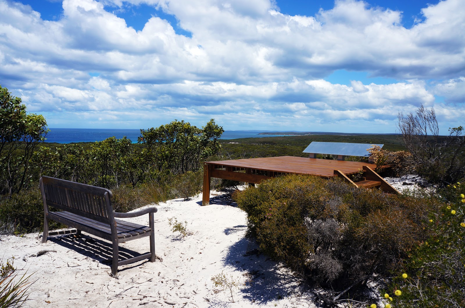
The Nuytsia Lookout is the first of the many lookouts encountered along the Mamang Trail, however it was probably the least impressive in terms of views. It was not tall enough to see beyond the nearby heath, and the namesake Nuytsia or Australian Christmas Trees were not in bloom. From here on in, the interpretive signage had not been installed at the time that we walked the trail, however I imagine the experience will be ever more rewarding once these are in place.

Not long after the Nuytsia Lookout is the Nuytsia Grove rest spot, with a park bench placed right under a Christmas Tree. Again, the trees were not in bloom at the time of walking, but it would definitely be a lovely spot to rest when they are - especially since there are few areas with resting spots in the shade along the trail.

Not long after Nuytsia Grove is a junction in the trail. The Mamang Trail is cleverly designed to offer half day, full day and overnight experiences, and the half day loop ends here via the Beach Link Trail. We were here to complete the entire trail, so Alissa and I pressed onwards to Fitzgerald Inlet.

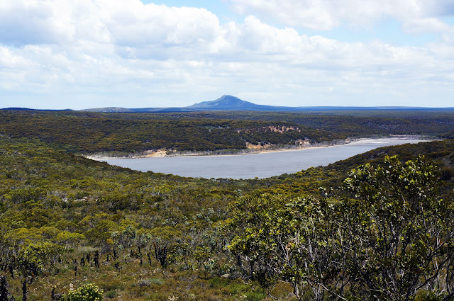
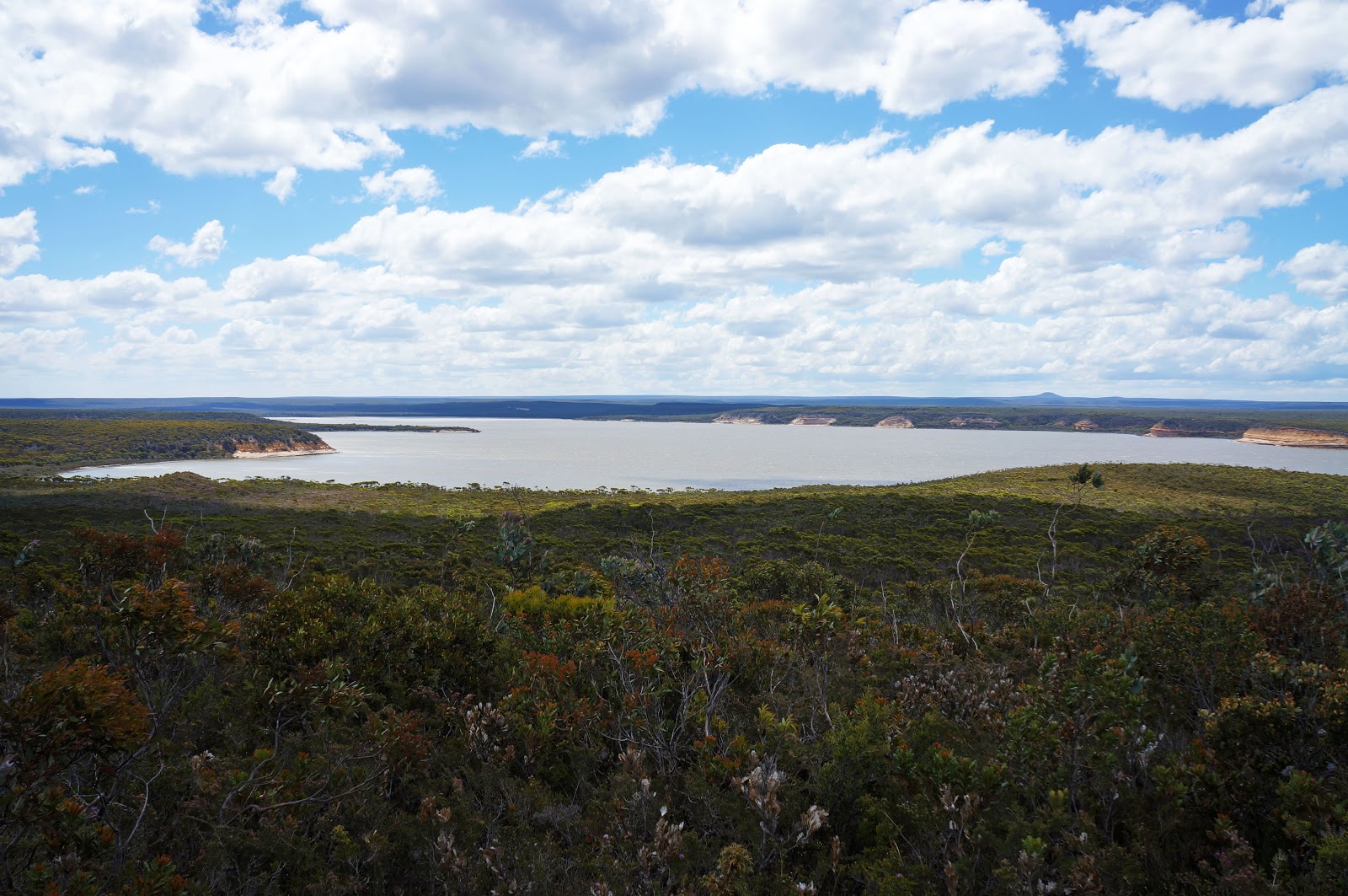
The Lake Nameless Lookout is the second along the track, and is a higher and more elaborate structure compared to the Nuytsia Lookout.

The lookout provides good views of Lake Nameless. Lake Nameless is so named because it had remained unnamed for a long time, and as such a ranger in the parked dubbed it Lake Nameless. The name stuck, and has become the lake's official name. Several rivers and inlets cross the coastline along Fitzgerald River National Park, and Lake Nameless was also once a river inlet that flowed into the ocean. With the nice benches and view, Alissa and I decided to stop for lunch at the Lake Nameless lookout before continuing on our way.

From the lookout, the trail enters an area dominated by mallee, smaller trees and larger shrubbery than in the heathland found earlier. This was the most hilly park of the walk, though only hilly relative to the rest of the walk; at most we would have climbed no more than 60 metres in elevation in this section!

An old, burnt out wooden pole along the track stands near Lake Nameless as a relic of an earlier time. This is a remnant of the former east-west Intercolonial Telegraph Line that ran from Albany to Eucla.

Not long after the old pole is the Intercolonial Rest Area - arguably one of the track's best rest areas along the inland section. Overlooking Lake Nameless from a better vantage point than the Lake Nameless Lookout, Alissa and I wished we'd stopped here for our lunch break, and I would recommend this as the best spot for hikers to designate as a rest point.

Noticeably absent from the walk so far had been Fitzgerald River National Park's most famous plant - the Royal Hakea. Not long after leaving Lake Nameless, we encountered the first specimens of this truly regal species, impressing us with their beautiful colours.

Soon we were walking through an area filled with Royal Hakea. Looking back towards Lake Nameless, Alissa and I could see the peak of West Mount Barren just beyond. West Mt Barren is one of the park's shorter trails, and looks superficially like a smaller version of a Stirling Range peak. The walk up to the summit is something Alissa and I will definitely return to do sometime in the future.

A short 50 metre spur leads to the Royal Hakea Lookout.
The lookout's name is definitely apt, as it provides a view of the fields of Royal Hakea nearby. It is also well regarded due to the 'surprise' view it offers of West Mt Barren in the background and Lake Nameless in the middle.

Another change in foliage occurs after the Royal Hakea lookout. Where the soil had largely been very sandy, it become a bit harder and rockier. Unsurprisingly, this also meant the chance to see a number of species we had not encountered earlier, with a mix of different hakeas, banksias and other flowering species growing along the track. Along this section, we encountered our one and only snake for the entire walk, which slithered away as soon as I relatively nearby. A bobtail lizard and I had a much closer encounter however, as I nearly walked right into it. The lizard and I both had a real fright as I adjusted my gait mid step to prevent standing on it, while it opened its mouth as a shocked defensive mechanism before running off.

While near Lake Nameless, the Central Wilderness Peaks were not as visible, however they once again served as a significant landmark from this point of the walk onwards.

Continuing along, walkers will come to the penultimate lookout of the Mamang Trail - the Fitzgerald Valley Lookout. The lookout provides a lovely view of the Fitzgerald Inlet. The park's namesake river, the inlet's sheer cliffs make for a lovely landscape that I only wish we could have explored more closely.

Beyond Fitzgerald Valley, the next major landmark is the Point Charles Junction. For walkers looking to complete the full day walk version of the Mamang Trail, a short trail leads walkers back to the coast over a series of dunes and provides an alternative return route back to Point Ann. We would take this shorter optional return route the next day, however some of the track's best walking was still to come.

Walking high along a coastal ridge, the track leads to the Point Charles. Looking back towards Point Ann, one can see many of the dagger-like rock formations common along the Fitzgerald River coastline.
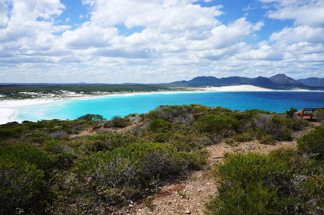
As the trail reached Point Charles, Alissa and I could see the beautiful secluded Fitzgerald Beach. Of some concern to us however was the obvious sight of the Fitzgerald Inlet being open. This was something we had been prepared for given the recent rains, however the visual confirmation made it fairly clear that there would definitely be some wading in our future.

The Point Charles Lookout features one of the best views along the trail, taking in the Fitzgerald Inlet, the bleach white sands of Fitzgerald Beach and its beautiful bay and the rugged Central Wilderness Peaks.

From the lookout, the trail descends to Fitzgerald Beach, passing one of the bright orange beach access markers.

The beach features some of the sharp, jutting out rock formations that are a feature of the park. These were however fairly small, and would be dwarfed by much larger formations we would encounter along the return beach route the next day.


As Alissa and I came to Fitzgerald Inlet, we investigated where the best crossing point would be. Although the breach in the sandbar was fairly narrow, the water was flowing fairly fast, indicating to us that the crossing would be deceptively deep at this point. Having crossed a chest deep Torbay Inlet on the Bibbulmun Track, I knew that the best place to cross an inlet is at the sea end so I took off my pack and gingerly checked that the crossing was safe enough to undertake.

Sure enough, the crossing was no more than knee deep, and after returning to get my pack Alissa and I made our way to the other side. Although the inlet is supposedly closed for most of the year, we actually really enjoyed the adventure of the crossing and it only improved the experience of the trail. Having made good time and knowing that the campsite was less than 2 kilometres away, Alissa and I decided to have a bit of a swim in the gentle, shallow waters of Fitzgerald Beach. Having an entire beach to yourself is a very rare privilege, especially at a beach as beautiful as this one.

After our swim, we got our packs back on and headed inland along the other side of the inlet. Again, the beach exit was clearly marked by a tall orange post that would be very hard to miss.

The trail continues along an old sandy four wheel drive track along the inlet. This brings about another change of vegetation with paperbarks and riverine species dominating.

Surrounded by white sand, the inlet provided another different and beautiful landscape along the walk. Native samphire was growing wild along the water's edge, with many waterbirds thriving in this pristine environment.

After walking for just over a kilometre along the sandy track, Alissa and I reached the end of the Mamang Trail at Fitzgerald Inlet campground. The campground looks to have been an old camping area predominantly used by campers with four wheel drives, however the barbecue facilities have been removed and it is now a simple campground for hikers. No water is provided here so walkers must bring all their water with them, however it does have picnic tables, clear campsites and a toilet - which is just about all the mod cons a hiker would really need.

After setting up our tent and sleeping bags, Alissa and I relaxed at Fitzgerald Inlet campground. It had been a very long time since Alissa and I had a campsite all to ourselves, and although we have appreciated socialising will fellow hikers, we enjoyed the rare feeling of being the only people out on the overnight version of the trail.
Although the Mamang Trail is often spoken about as the lesser of the two overnight hikes in Fitzgerald National Park, Alissa and I were thoroughly impressed by what the Mamang Trail had to offer. The bleach white beaches and crystal clear waters here were some of the most beautiful we had ever seen, the Central Wilderness Peaks were a stunning vista to behold and the wildflower display in the heathlands was truly second to none. At 15.4 kilometres from Point Ann to Fitzgerald Inlet and in gently undulating terrain, the full length of the Mamang Trail is a fairly easy overnight hike compared to sections of the Bibbulmun Track (apart from the need to carry water and the potential inlet crossing), and yet the Mamang Trail really felt like much more of a wilderness walk that really gets away from it all. Apart from the fact its quite a difficult park to access via long unsealed roads and a fair drive away from Perth, I would consider the Mamang trail ideal for hikers transitioning from day walks to overnight hiking - especially since the return walk offers a different alternative route with its own charms.

Although Alissa and I are very frequent visitors to the Southern Forests and Great Southern regions of Australia's South West, Albany has long been something of an eastern line in the sand for our travels Down South. Although we both journeyed to places like Esperance and Waychinicup in our youth, its an area we'd never hiked in largely due to the inconveniently far distance required to get there. Emboldened by our recent drives to Kalbarri National Park and a strong recommendation from hikers we'd met on the Bibbulmun Track, Alissa and I decided to spend a weekend checking out the Mamang Trail - one of two recently constructed overnight hikes in Fitzgerald River National Park. With self-contained overnight hikes a relative rarity in Western Australia and Fitzgerald River's reputation as one of the three best parks for seeing wildflowers in Western Australia, we were excited to see what this fairly new trail was all about.
Fitzgerald River National Park is huge, stretching over 2,972 km² of pristine bush and coastline, with a central wilderness area. As such, the park has a western and eastern side, with the Mamang Trail located on the Bremer Bay side of the park. Its a long drive down unsealed road to get to the trail's start at Point Ann, however the trail infrastructure is excellent, with a clear, informative trailhead and benches right at the start of the walk. Fitzgerald River is one of the Western Australian parks least effected by Dieback, so ensure that you use all the brush down stations all along this walk to protect this important, internationally recognised biodiversity hotspot.

The publicity material for the Mamang Trail refers to it as being a world class trail, and the infrastructure along the walk is definitely very impressive. Interpretive panels are located at key points along the walk, as well as benches, lookouts and some of the best and most informative trail markers I've seen in Western Australia. This is a very detailed trail; the only other trail that comes close to the Mamang Trail's infrastructure and attention to detail would be the Numbat Track in Paruna Wildlife Sanctuary.

From Point Ann, the walkers follow a well constructed path through coastal heath that leads to St Mary Beach. All trails in Fitzgerald River National Park use the symbol of the Royal Hakea as trail markers, with clear directional arrows provided at crucial turns.

Alissa and I were immediately taken by how beautiful St Mary Beach is. The exceptionally white sand was so fine that it squeaked as we walked along it, and the waters were the very definition of crystal clear. In the distance, we could see the Central Wilderness Peaks that are an iconic sight along this walk. Although the Mamang Trail stops short of the peaks due to their wilderness values, it does head in their general direction all the way to the Fitzgerald Inlet.

Little more than a kilometre into the walk, the trail cross a sandbar over the mouth of the St Mary River. In spite of recent heavy rains, the river was still some distance away from the ocean and I imagine that it is rarely open at all.

Compared to the hellishly soft walking on Mazzoletti Beach along the Bibbulmun earlier this year, St Mary Beach was fairly firm under foot and made for a relatively easy beach walk. We were the only people along the entire beach, and except for the barnacle-encrusted helmet that had washed ashore, the beach showed little sign of human intervention.

A kilometre after crossing St Mary Inlet, the trail heads inland across the dunes. Like the Bibbulmun Track, beach exits are marked with conspicuous orange poles so they are fairly easy to spot in the sea of white sand.

As the trail turns inland, walkers will encounter one of the Mamang Trail's more detailed trail markers, with helpful information about how far away the main landmarks are. You occasionally see such information on the Bibbulmun Track and on tourist friendly day walks like Bluff Knoll and the Granite Skywalk, but this is still definitely an unusually detailed but very much welcome level of information.

From here, the trail walks through much of the biodiverse heath that the park is famous for. Although a mere 0.2% of the state's land mass, an incredible 20% of the state's flora can be found in Fitzgerald National Park. Having visited the other two most biodiverse parks in Western Australia earlier this year - Stirling Range and Lesueur - Alissa and I agreed that Fitzgerald River's wildflower bloom was even more spectacular due to the mix of coastal and inland heath species.

The Nuytsia Lookout is the first of the many lookouts encountered along the Mamang Trail, however it was probably the least impressive in terms of views. It was not tall enough to see beyond the nearby heath, and the namesake Nuytsia or Australian Christmas Trees were not in bloom. From here on in, the interpretive signage had not been installed at the time that we walked the trail, however I imagine the experience will be ever more rewarding once these are in place.

Not long after the Nuytsia Lookout is the Nuytsia Grove rest spot, with a park bench placed right under a Christmas Tree. Again, the trees were not in bloom at the time of walking, but it would definitely be a lovely spot to rest when they are - especially since there are few areas with resting spots in the shade along the trail.

Not long after Nuytsia Grove is a junction in the trail. The Mamang Trail is cleverly designed to offer half day, full day and overnight experiences, and the half day loop ends here via the Beach Link Trail. We were here to complete the entire trail, so Alissa and I pressed onwards to Fitzgerald Inlet.

The Lake Nameless Lookout is the second along the track, and is a higher and more elaborate structure compared to the Nuytsia Lookout.

The lookout provides good views of Lake Nameless. Lake Nameless is so named because it had remained unnamed for a long time, and as such a ranger in the parked dubbed it Lake Nameless. The name stuck, and has become the lake's official name. Several rivers and inlets cross the coastline along Fitzgerald River National Park, and Lake Nameless was also once a river inlet that flowed into the ocean. With the nice benches and view, Alissa and I decided to stop for lunch at the Lake Nameless lookout before continuing on our way.

From the lookout, the trail enters an area dominated by mallee, smaller trees and larger shrubbery than in the heathland found earlier. This was the most hilly park of the walk, though only hilly relative to the rest of the walk; at most we would have climbed no more than 60 metres in elevation in this section!

An old, burnt out wooden pole along the track stands near Lake Nameless as a relic of an earlier time. This is a remnant of the former east-west Intercolonial Telegraph Line that ran from Albany to Eucla.

Not long after the old pole is the Intercolonial Rest Area - arguably one of the track's best rest areas along the inland section. Overlooking Lake Nameless from a better vantage point than the Lake Nameless Lookout, Alissa and I wished we'd stopped here for our lunch break, and I would recommend this as the best spot for hikers to designate as a rest point.

Noticeably absent from the walk so far had been Fitzgerald River National Park's most famous plant - the Royal Hakea. Not long after leaving Lake Nameless, we encountered the first specimens of this truly regal species, impressing us with their beautiful colours.

Soon we were walking through an area filled with Royal Hakea. Looking back towards Lake Nameless, Alissa and I could see the peak of West Mount Barren just beyond. West Mt Barren is one of the park's shorter trails, and looks superficially like a smaller version of a Stirling Range peak. The walk up to the summit is something Alissa and I will definitely return to do sometime in the future.
A short 50 metre spur leads to the Royal Hakea Lookout.

The lookout's name is definitely apt, as it provides a view of the fields of Royal Hakea nearby. It is also well regarded due to the 'surprise' view it offers of West Mt Barren in the background and Lake Nameless in the middle.

Another change in foliage occurs after the Royal Hakea lookout. Where the soil had largely been very sandy, it become a bit harder and rockier. Unsurprisingly, this also meant the chance to see a number of species we had not encountered earlier, with a mix of different hakeas, banksias and other flowering species growing along the track. Along this section, we encountered our one and only snake for the entire walk, which slithered away as soon as I relatively nearby. A bobtail lizard and I had a much closer encounter however, as I nearly walked right into it. The lizard and I both had a real fright as I adjusted my gait mid step to prevent standing on it, while it opened its mouth as a shocked defensive mechanism before running off.

While near Lake Nameless, the Central Wilderness Peaks were not as visible, however they once again served as a significant landmark from this point of the walk onwards.
Continuing along, walkers will come to the penultimate lookout of the Mamang Trail - the Fitzgerald Valley Lookout. The lookout provides a lovely view of the Fitzgerald Inlet. The park's namesake river, the inlet's sheer cliffs make for a lovely landscape that I only wish we could have explored more closely.

Beyond Fitzgerald Valley, the next major landmark is the Point Charles Junction. For walkers looking to complete the full day walk version of the Mamang Trail, a short trail leads walkers back to the coast over a series of dunes and provides an alternative return route back to Point Ann. We would take this shorter optional return route the next day, however some of the track's best walking was still to come.

Walking high along a coastal ridge, the track leads to the Point Charles. Looking back towards Point Ann, one can see many of the dagger-like rock formations common along the Fitzgerald River coastline.

As the trail reached Point Charles, Alissa and I could see the beautiful secluded Fitzgerald Beach. Of some concern to us however was the obvious sight of the Fitzgerald Inlet being open. This was something we had been prepared for given the recent rains, however the visual confirmation made it fairly clear that there would definitely be some wading in our future.
The Point Charles Lookout features one of the best views along the trail, taking in the Fitzgerald Inlet, the bleach white sands of Fitzgerald Beach and its beautiful bay and the rugged Central Wilderness Peaks.

From the lookout, the trail descends to Fitzgerald Beach, passing one of the bright orange beach access markers.

The beach features some of the sharp, jutting out rock formations that are a feature of the park. These were however fairly small, and would be dwarfed by much larger formations we would encounter along the return beach route the next day.


As Alissa and I came to Fitzgerald Inlet, we investigated where the best crossing point would be. Although the breach in the sandbar was fairly narrow, the water was flowing fairly fast, indicating to us that the crossing would be deceptively deep at this point. Having crossed a chest deep Torbay Inlet on the Bibbulmun Track, I knew that the best place to cross an inlet is at the sea end so I took off my pack and gingerly checked that the crossing was safe enough to undertake.

Sure enough, the crossing was no more than knee deep, and after returning to get my pack Alissa and I made our way to the other side. Although the inlet is supposedly closed for most of the year, we actually really enjoyed the adventure of the crossing and it only improved the experience of the trail. Having made good time and knowing that the campsite was less than 2 kilometres away, Alissa and I decided to have a bit of a swim in the gentle, shallow waters of Fitzgerald Beach. Having an entire beach to yourself is a very rare privilege, especially at a beach as beautiful as this one.

After our swim, we got our packs back on and headed inland along the other side of the inlet. Again, the beach exit was clearly marked by a tall orange post that would be very hard to miss.

The trail continues along an old sandy four wheel drive track along the inlet. This brings about another change of vegetation with paperbarks and riverine species dominating.

Surrounded by white sand, the inlet provided another different and beautiful landscape along the walk. Native samphire was growing wild along the water's edge, with many waterbirds thriving in this pristine environment.

After walking for just over a kilometre along the sandy track, Alissa and I reached the end of the Mamang Trail at Fitzgerald Inlet campground. The campground looks to have been an old camping area predominantly used by campers with four wheel drives, however the barbecue facilities have been removed and it is now a simple campground for hikers. No water is provided here so walkers must bring all their water with them, however it does have picnic tables, clear campsites and a toilet - which is just about all the mod cons a hiker would really need.

After setting up our tent and sleeping bags, Alissa and I relaxed at Fitzgerald Inlet campground. It had been a very long time since Alissa and I had a campsite all to ourselves, and although we have appreciated socialising will fellow hikers, we enjoyed the rare feeling of being the only people out on the overnight version of the trail.
Although the Mamang Trail is often spoken about as the lesser of the two overnight hikes in Fitzgerald National Park, Alissa and I were thoroughly impressed by what the Mamang Trail had to offer. The bleach white beaches and crystal clear waters here were some of the most beautiful we had ever seen, the Central Wilderness Peaks were a stunning vista to behold and the wildflower display in the heathlands was truly second to none. At 15.4 kilometres from Point Ann to Fitzgerald Inlet and in gently undulating terrain, the full length of the Mamang Trail is a fairly easy overnight hike compared to sections of the Bibbulmun Track (apart from the need to carry water and the potential inlet crossing), and yet the Mamang Trail really felt like much more of a wilderness walk that really gets away from it all. Apart from the fact its quite a difficult park to access via long unsealed roads and a fair drive away from Perth, I would consider the Mamang trail ideal for hikers transitioning from day walks to overnight hiking - especially since the return walk offers a different alternative route with its own charms.


Thanks! A really informative description of this walk which helped our planning.
ReplyDeleteHi SarahK, you are most welcome. I love this walk and national park in general and I am glad that our guide was of help to you in planning your visit!
DeleteThanks for the very informative write-up of the trail. I am hoping to explore it later in the year as part of bikepacking ride from Esperance to Albany.
ReplyDeleteHi Aushiker, glad that you found the information helpful! We love Fitzgerald River NP - it is probably one of the best and most pristine areas in the state!
DeleteAre you planning on bikepacking along the track or are you doing this as an on foot side trip? The Mamang and Hakea Trails are walk trails only, and given the great risk of spreading Dieback I'd be very wary about cycling along these trails - it because of the Dieback risk that the trails are not one long multiday hike across the entire park (that was the original plan).
It is probably best you get in touch with the DPaW Office in Albany to discuss your plans if you are indeed planning to cycle the walk trails.
Thanks for this. I really like what you've posted here and wish you the best of luck with this blog and thanks for sharing. Point cloud WA
ReplyDelete