

Arguably the best sectional day walk in the Darling Scarp, this 22 kilometre trek takes walkers from the little known access point on Marginata Rd to Sullivan Rock. Along the way, walkers get to cross a bridge over the same Canning River that feeds into the Swan River and climb over the small mountains of Mt Cuthbert and Mt Vincent. With stunning views of of the Darling Scarp, this is a walk of challenge and reward in equal measure.
Distance: 22 km (one way)
Gradient: Relatively gentle gradient for first half, but then with several hills and two small mountains in the second.
Quality of Path: Generally clear and well maintained. Sullivan Rock and Mt Cuthbert are largely made of granite - extra care must be taken in wet and slippery conditions.
Quality of Signage: Well signed, with the Waugal providing very clear directional information with cairns providing extra way marking on Sullivan Rock and the small mountains.
Experience Required: Bush Walking Experience Recommended.
Time: 6.5 Hours, including lunch at Monadnocks Campsite
Steps: Some steps in places, especially on the inclines.
Best Time to Visit: Late Winter/Early Spring. Best to avoid in particularly hot weather.
Entry Fee: No
Entry Fee: No
Getting There: The Marginata Rd access point is not the easiest to find, and I have written a separate guide for finding this access point. Read the guide here. Sullivan Rock is easier to find, and is 9km from Jarrahdale Rd with a car park and picnic area on the western side of the highway.

After parking up our vehicles at Sullivan Rock and our start point on Marginata Rd, Alissa and I set off for one of the longer sectional day walks of the Bibbulmun in the northern section, incidentally on the hottest day of Spring. Having already had a bad experience trying to find the Bibbulmun from Marginata Rd, we thankfully found the correct turn-off along the old forestry tracks (you can read the separate guide to Marginata Rd for more info). The walk in along Marginata and Four Ways Rds and the first few kilometres of the Bibbulmun Track are dominated by thin, scrappy Jarrah woodlands that are pleasant enough but not exactly amazing either. The odd fallen tree across the track served to break up some of the monotony, and there were a number in this section for some reason.

The trail eventually enters an area of taller virgin Jarrah as well as some minor creeks and thick understorey. This change of scenery indicates that the trail is heading close to the Canning River.

Just before the river crossing, the track passes by a large expanse of granite almost entirely covered in moss, with tall Jarrah trees surrounding it.

Living near Canning Bridge in the City of Melville and regularly walking the loop between Canning and Mt Henry Bridges, it was really interesting to see the Canning River along the Bibbulmun and in an area decidedly wilder than the suburbia that surrounds it much further downstream.

This is a really lovely spot, and there were some cleared areas near the river that showed signs of people having camped here recently. I'm not sure if this is permitted, but I can certainly see why someone would stay at this tranquil spot. We were lucky to be walking this section in late Winter as the river was quite high, but apparently the area near the bridge is a permanent billabong, with water lasting all the way through Summer.

The section between Canning River and Monadnock campsite is admittedly fairly standard Darling Scarp scenery, with Grass Trees and small Jarrah dominating.

Given that this is river country, there are a lot of small streams that cross the track, though most were dry even in mid August.

The track crosses Randall Road and continues on a wide old vehicle track. Walkers looking to do the track as as a shorter day walk could park their car just south of Gleneagle Pine Plantation and walk in via Randall Rd. This is a good way to focus mainly on the Monadnocks, and although it misses Canning River it also cuts out some of the dull walking between the river and the campsite.

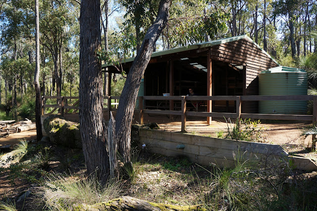
Monadnocks Campsite is one of the nicest looking in the Darling Scarp, with a large hut in the 'Deep South' design surrounded by peaceful and shady Jarrah forest. The area around the hut is nicely landscaped and features a lower level with its own table and fire ring. The hut also features two water tanks - a sign of the Monadnocks campsite's popularity. Alissa and I stopped for lunch, but agreed that this would be a great hut to take people looking to transition to overnight hiking as its an inviting place to stay.


The track onward from Monadnocks descends at first before rising through more Jarrah woodlands.

The ascent initially starts through laterite soils and passes by some strands of Wandoo. As the track gets higher, the laterite gives way to exposed granite, while cairns and this rock arrow build anticipation for the summit to come.

At many points, the track levels out, allowing walkers to take in expansive views of the the many hills and small mountains that make up the Darling Scarp.


After following cairns over the granite monadnock for a few hundred metres, we finally reached the summit of Mt Cuthbert. With its bald granite dome and ephemeral Gnamma pools, it is the prettier of the day's two small mountains and its relatively treelessness offers stunning 360° views.

On the descent, Mt Vincent can be seen immediately south, with a small valley lying between the two peaks.

Unlike Mt Cuthbert, the trail up Mt Vincent does not clear to bare granite - at least not on the northern side. While offering less in the way of views, it also means that Mt Vincent supports more plants that the preceding Monadnock, and is blanketed in a plethora of wildflowers if walked at the right time of year (we walked in August, but I assume September would be even more spectacular).


The summit of Mt Vincent could not be more different to Mt Cuthbert, with a Grass Tree growing right next to the summit cairn, and the entire area surrounded be shrubbery.

The southern slope of the mountain features a lot more granite rock formations, and descends in a clearing where the laterite soils must be rather thin given the lack of trees. A tall old Jarrah stands oddly out of place - a survivor from an earlier time when most of this area was covered in much larger and taller trees.


From the granite slope, the track continues in Jarrah forest before a spur trail leads to Sullivan Rock, a large granite rock formation I covered in more detail in Sullivan Rock to Powerline Rd via Mt Cooke.
Although the section between Canning River and Monadnocks campsite is a bit dull, this is easily one of (if not the) best sections of the Bibbulmun Track in the Darling Scarp - and arguably one of Perth's finest day walks. Being such a flat state, the fact that this track climbs to the top of two peaks is a real treat, and both being so vastly different makes this even better. For those looking to keep it to the mountain highlights, using Randall Rd to walk from before Monadnocks campsite to Sullivan Rock would make a more solid and concise walk, though I would recommend the longer version for those who are considering a sectional End to End. Regardless, this and the next section to Mt Cooke are essential walking for bushwalkers in the Perth area and a good mountain walking introduction for those looking to undertake more serious mountain walks.

After parking up our vehicles at Sullivan Rock and our start point on Marginata Rd, Alissa and I set off for one of the longer sectional day walks of the Bibbulmun in the northern section, incidentally on the hottest day of Spring. Having already had a bad experience trying to find the Bibbulmun from Marginata Rd, we thankfully found the correct turn-off along the old forestry tracks (you can read the separate guide to Marginata Rd for more info). The walk in along Marginata and Four Ways Rds and the first few kilometres of the Bibbulmun Track are dominated by thin, scrappy Jarrah woodlands that are pleasant enough but not exactly amazing either. The odd fallen tree across the track served to break up some of the monotony, and there were a number in this section for some reason.

The trail eventually enters an area of taller virgin Jarrah as well as some minor creeks and thick understorey. This change of scenery indicates that the trail is heading close to the Canning River.

Just before the river crossing, the track passes by a large expanse of granite almost entirely covered in moss, with tall Jarrah trees surrounding it.

Living near Canning Bridge in the City of Melville and regularly walking the loop between Canning and Mt Henry Bridges, it was really interesting to see the Canning River along the Bibbulmun and in an area decidedly wilder than the suburbia that surrounds it much further downstream.

This is a really lovely spot, and there were some cleared areas near the river that showed signs of people having camped here recently. I'm not sure if this is permitted, but I can certainly see why someone would stay at this tranquil spot. We were lucky to be walking this section in late Winter as the river was quite high, but apparently the area near the bridge is a permanent billabong, with water lasting all the way through Summer.

The section between Canning River and Monadnock campsite is admittedly fairly standard Darling Scarp scenery, with Grass Trees and small Jarrah dominating.

Given that this is river country, there are a lot of small streams that cross the track, though most were dry even in mid August.

The track crosses Randall Road and continues on a wide old vehicle track. Walkers looking to do the track as as a shorter day walk could park their car just south of Gleneagle Pine Plantation and walk in via Randall Rd. This is a good way to focus mainly on the Monadnocks, and although it misses Canning River it also cuts out some of the dull walking between the river and the campsite.


Monadnocks Campsite is one of the nicest looking in the Darling Scarp, with a large hut in the 'Deep South' design surrounded by peaceful and shady Jarrah forest. The area around the hut is nicely landscaped and features a lower level with its own table and fire ring. The hut also features two water tanks - a sign of the Monadnocks campsite's popularity. Alissa and I stopped for lunch, but agreed that this would be a great hut to take people looking to transition to overnight hiking as its an inviting place to stay.


The track onward from Monadnocks descends at first before rising through more Jarrah woodlands.

The ascent initially starts through laterite soils and passes by some strands of Wandoo. As the track gets higher, the laterite gives way to exposed granite, while cairns and this rock arrow build anticipation for the summit to come.

At many points, the track levels out, allowing walkers to take in expansive views of the the many hills and small mountains that make up the Darling Scarp.

After following cairns over the granite monadnock for a few hundred metres, we finally reached the summit of Mt Cuthbert. With its bald granite dome and ephemeral Gnamma pools, it is the prettier of the day's two small mountains and its relatively treelessness offers stunning 360° views.

On the descent, Mt Vincent can be seen immediately south, with a small valley lying between the two peaks.

Unlike Mt Cuthbert, the trail up Mt Vincent does not clear to bare granite - at least not on the northern side. While offering less in the way of views, it also means that Mt Vincent supports more plants that the preceding Monadnock, and is blanketed in a plethora of wildflowers if walked at the right time of year (we walked in August, but I assume September would be even more spectacular).


The summit of Mt Vincent could not be more different to Mt Cuthbert, with a Grass Tree growing right next to the summit cairn, and the entire area surrounded be shrubbery.

The southern slope of the mountain features a lot more granite rock formations, and descends in a clearing where the laterite soils must be rather thin given the lack of trees. A tall old Jarrah stands oddly out of place - a survivor from an earlier time when most of this area was covered in much larger and taller trees.


From the granite slope, the track continues in Jarrah forest before a spur trail leads to Sullivan Rock, a large granite rock formation I covered in more detail in Sullivan Rock to Powerline Rd via Mt Cooke.
Although the section between Canning River and Monadnocks campsite is a bit dull, this is easily one of (if not the) best sections of the Bibbulmun Track in the Darling Scarp - and arguably one of Perth's finest day walks. Being such a flat state, the fact that this track climbs to the top of two peaks is a real treat, and both being so vastly different makes this even better. For those looking to keep it to the mountain highlights, using Randall Rd to walk from before Monadnocks campsite to Sullivan Rock would make a more solid and concise walk, though I would recommend the longer version for those who are considering a sectional End to End. Regardless, this and the next section to Mt Cooke are essential walking for bushwalkers in the Perth area and a good mountain walking introduction for those looking to undertake more serious mountain walks.


0 comments:
Post a Comment